ATL: GONZALO - Post-Tropical - Discussion
Moderator: S2k Moderators

-
cycloneye

- Admin

- Posts: 149508
- Age: 69
- Joined: Thu Oct 10, 2002 10:54 am
- Location: San Juan, Puerto Rico
Re: ATL: GONZALO - Tropical Storm - Discussion
SUMMARY OF 800 PM AST...0000 UTC...INFORMATION
----------------------------------------------
LOCATION...16.4N 59.7W
ABOUT 115 MI...180 KM E OF GUADELOUPE
ABOUT 145 MI...235 KM ESE OF ANTIGUA
MAXIMUM SUSTAINED WINDS...45 MPH...75 KM/H
PRESENT MOVEMENT...W OR 270 DEGREES AT 10 MPH...17 KM/H
MINIMUM CENTRAL PRESSURE...1002 MB...29.59 INCHES
----------------------------------------------
LOCATION...16.4N 59.7W
ABOUT 115 MI...180 KM E OF GUADELOUPE
ABOUT 145 MI...235 KM ESE OF ANTIGUA
MAXIMUM SUSTAINED WINDS...45 MPH...75 KM/H
PRESENT MOVEMENT...W OR 270 DEGREES AT 10 MPH...17 KM/H
MINIMUM CENTRAL PRESSURE...1002 MB...29.59 INCHES
0 likes
Visit the Caribbean-Central America Weather Thread where you can find at first post web cams,radars
and observations from Caribbean basin members Click Here
and observations from Caribbean basin members Click Here


Re: ATL: GONZALO - Tropical Storm - Discussion
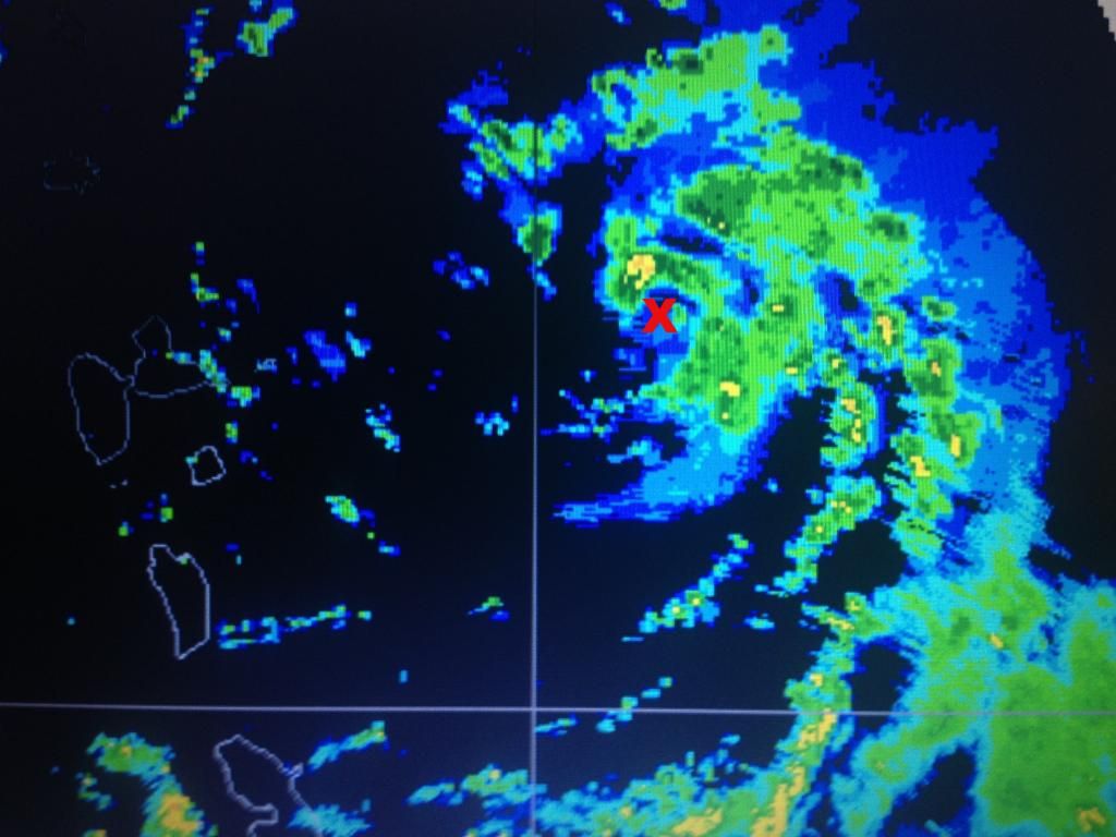
Radar from Martinique agrees with microwave data of a very well defined LLC with a small eye like feature, very tight LLC at least.
Radar shows that it is moving almost due west.
Radar shows that it is moving almost due west.
0 likes

Re: Re:
SeGaBob wrote:caribepr wrote:SeGaBob wrote:I'm noticing the people that said this wouldn't form 24 hours ago have nothing to say...Look at pages 3 and 4.
Nothing to be gained from that, it happens both ways on all possibles. Ram Dass said it best, Be Here Now.
True, I just felt the need to say it though because some think they know it all. In no way do I mean to seem rude but it just eats me up sometimes.I don't mean to get off topic though... this storm looks really good to me. I don't want this to be a hurricane in PR and surrounding areas.
I personally got too hung up on land interaction, but in the end it seems like the Euro was just up to its old game with the mid-range. At the moment it looks like it's headed into some very weak westerly shear (watch the high clouds over Antigua are from the south then very weakly out of the west.) Hopefully this combined with dry air could slow intensification until after it passes the islands, but this may also be a very temporary trend, and if convection explodes overnight it could also reestablish western outflow.
edit: Checked radar, seems to be a weak western eyewall, but it could be midlevel and the actual center could be just under or to the west of that 'eyewall'. And it may end up being quite stronger than expected when the plane gets there in the morning.
Last edited by Hammy on Sun Oct 12, 2014 6:45 pm, edited 1 time in total.
0 likes
The above post is not official and should not be used as such. It is the opinion of the poster and may or may not be backed by sound meteorological data. It is not endorsed by any professional institution or storm2k.org. For official information, please refer to the NHC and NWS products.

Re: ATL: GONZALO - Tropical Storm - Discussion
cycloneye wrote:SUMMARY OF 800 PM AST...0000 UTC...INFORMATION
----------------------------------------------
LOCATION...16.4N 59.7W
ABOUT 115 MI...180 KM E OF GUADELOUPE
ABOUT 145 MI...235 KM ESE OF ANTIGUA
MAXIMUM SUSTAINED WINDS...45 MPH...75 KM/H
PRESENT MOVEMENT...W OR 270 DEGREES AT 10 MPH...17 KM/H
MINIMUM CENTRAL PRESSURE...1002 MB...29.59 INCHES
That's an additional 2 MB drop in just 3 hours.
0 likes

Re: Re:
Hammy wrote:SeGaBob wrote:caribepr wrote:
Nothing to be gained from that, it happens both ways on all possibles. Ram Dass said it best, Be Here Now.
True, I just felt the need to say it though because some think they know it all. In no way do I mean to seem rude but it just eats me up sometimes.
I personally got too hung up on land interaction, but in the end it seems like the Euro was just up to its old game with the mid-range. At the moment it looks like it's headed into some very weak westerly shear (watch the high clouds over Antigua are from the south then very weakly out of the west.) Hopefully this combined with dry air could slow intensification until after it passes the islands, but this may also be a very temporary trend, and if convection explodes overnight it could also reestablish western outflow.
18z SHIPS forecasts shear to stay around 10 knots if not lower at least over the next 48 hrs, and most importantly & most damaging mid level shear is non-existent around this system.
0 likes
-
Gustywind

- Category 5

- Posts: 12334
- Joined: Mon Sep 03, 2007 7:29 am
- Location: Baie-Mahault, GUADELOUPE
Re: ATL: GONZALO - Tropical Storm - Discussion
abajan wrote:cycloneye wrote:SUMMARY OF 800 PM AST...0000 UTC...INFORMATION
----------------------------------------------
LOCATION...16.4N 59.7W
ABOUT 115 MI...180 KM E OF GUADELOUPE
ABOUT 145 MI...235 KM ESE OF ANTIGUA
MAXIMUM SUSTAINED WINDS...45 MPH...75 KM/H
PRESENT MOVEMENT...W OR 270 DEGREES AT 10 MPH...17 KM/H
MINIMUM CENTRAL PRESSURE...1002 MB...29.59 INCHES
That's an additional 2 MB drop in just 3 hours.
Very very impressive drop since 130 PM... that means 7 mb in less than 7 hours
0 likes
-
SouthDadeFish

- Professional-Met

- Posts: 2835
- Joined: Thu Sep 23, 2010 2:54 pm
- Location: Miami, FL
- Contact:
Re: Re:
TARHEELPROGRAMMER wrote:SouthDadeFish wrote:Excellent inner structure for a weak TS. With a deep convective burst tonight, this thing could take off.
In my opinion this thing is close to hurricane strength already but I could be wrong.
Theres not any evidence of that IMO. However, like SDF said, the structure is very impressive.
0 likes
-
TARHEELPROGRAMMER
Re: Re:
RL3AO wrote:TARHEELPROGRAMMER wrote:SouthDadeFish wrote:Excellent inner structure for a weak TS. With a deep convective burst tonight, this thing could take off.
In my opinion this thing is close to hurricane strength already but I could be wrong.
Theres not any evidence of that IMO. However, like SDF said, the structure is very impressive.
Did the plane ever fly into the storm?
0 likes
-
cycloneye
- Admin
- Posts: 149508
- Age: 69
- Joined: Thu Oct 10, 2002 10:54 am
- Location: San Juan, Puerto Rico
Re: ATL: GONZALO - Tropical Storm - Discussion
00z Best Track
LATCUR = 16.5N LONCUR = 59.7W 1002 DIRCUR = 270DEG SPDCUR = 10KT
LATCUR = 16.5N LONCUR = 59.7W 1002 DIRCUR = 270DEG SPDCUR = 10KT
0 likes
Visit the Caribbean-Central America Weather Thread where you can find at first post web cams,radars
and observations from Caribbean basin members Click Here
and observations from Caribbean basin members Click Here
-
TARHEELPROGRAMMER
Re:
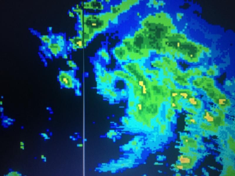
NDG wrote:Very small & tight eyelike feature still very evident on radar:
http://www.meteo.fr/temps/domtom/antill ... C_ant.html
You can see it here last few frames good.
0 likes
-
ozonepete
- Professional-Met
- Posts: 4743
- Joined: Mon Sep 07, 2009 3:23 pm
- Location: From Ozone Park, NYC / Now in Brooklyn, NY
Re:
NDG wrote:No increase on its T numbers at 0z.
12/2345 UTC 16.5N 59.3W T2.0/2.0 GONZALO
Yeah, I'm guessing because even though the symmetry is quite good the convection is ragged right now. And I suspect that's because there's enough dry getting ingested to prevent a really large uniform CDO. If that happens this will surely bomb out. Let's hope not.
0 likes
Who is online
Users browsing this forum: No registered users and 33 guests