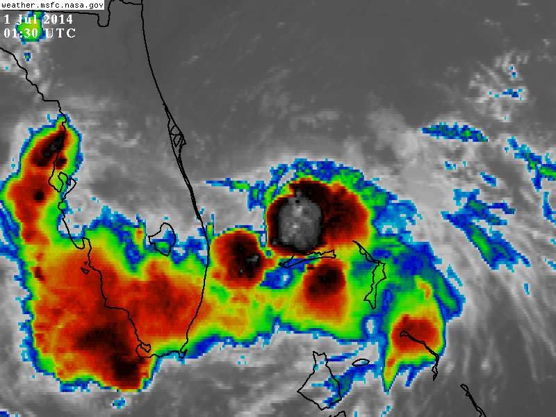
ATL: INVEST 92L - Discussion

Moderator: S2k Moderators

Message
Author
jlauderdal
S2K Supporter
S2K Supporter
Posts: 7177
Joined: Wed May 19, 2004 5:46 am
Location: NE Fort Lauderdale
Contact:

Re: ATL: INVEST 92L - Discussion

#381 Postby jlauderdal » Thu Sep 11, 2014 1:49 pm

fci wrote:
NDG wrote:12z Euro paints a very wet forecast for S FL over the next 36-48 hrs.

Local Met said that HPC had up to 8 inches through Sunday for SE Fla.

sw flow on the backside should be very favorable especially if we get some heating on sat and sun
0 likes   

User avatar
Bocadude85
Category 5
Category 5
Posts: 2991
Age: 38
Joined: Mon Apr 18, 2005 2:20 pm
Location: Honolulu,Hi

Re:

#382 Postby Bocadude85 » Thu Sep 11, 2014 1:50 pm

Hammy wrote:Anyone thinking this will be upgraded at 11 tonight given the proximity to land if it maintains steady convection until then?


Honestly I'd be surprised to see them upgrade this unless convection can really sustain itself.
0 likes   

windnrain
Category 2
Category 2
Posts: 670
Joined: Wed Aug 10, 2005 1:19 pm
Location: Baton Rouge

Re: ATL: INVEST 92L - Discussion

#383 Postby windnrain » Thu Sep 11, 2014 1:51 pm

The convection is more than maintaining itself. On the 5 minute frame, it seems every single frame adds more and more.

http://wwwghcc.msfc.nasa.gov/cgi-bin/ge ... mframes=25
0 likes   

User avatar
gatorcane
S2K Supporter
S2K Supporter
Posts: 23689
Age: 47
Joined: Sun Mar 13, 2005 3:54 pm
Location: Boca Raton, FL

Re: Re:

#384 Postby gatorcane » Thu Sep 11, 2014 1:52 pm

Bocadude85 wrote:
Hammy wrote:Anyone thinking this will be upgraded at 11 tonight given the proximity to land if it maintains steady convection until then?


Honestly I'd be surprised to see them upgrade this unless convection can really sustain itself.


If the convection keeps up like it is, maybe a special advisory before 11PM EST....

It probably is feeling those very warm Gulf stream waters. They can really fuel a system, despite a marginal environment.
0 likes   

User avatar
MississippiWx
S2K Supporter
S2K Supporter
Posts: 1696
Joined: Sat Aug 14, 2010 1:44 pm
Location: Hattiesburg, Mississippi

Re: ATL: INVEST 92L - Discussion

#385 Postby MississippiWx » Thu Sep 11, 2014 1:52 pm

Florida is very lucky that shear is having its way with this system. Otherwise, it would be a rapidly intensifying system coming ashore.
0 likes   
This post is not an official forecast and should not be used as such. It is just the opinion of MississippiWx and may or may not be backed by sound meteorological data. It is not endorsed by any professional institution including storm2k.org. For Official Information please refer to the NHC and NWS products.

Sanibel
Category 5
Category 5
Posts: 10375
Joined: Mon Aug 30, 2004 11:06 pm
Location: Offshore SW Florida

Re: ATL: INVEST 92L - Discussion

#386 Postby Sanibel » Thu Sep 11, 2014 1:53 pm

Vertical wind shear from the NNE is keeping it in check.
0 likes   

User avatar
NDG
S2K Supporter
S2K Supporter
Posts: 15446
Joined: Sun Jul 09, 2006 10:14 pm
Location: Orlando, FL

#387 Postby NDG » Thu Sep 11, 2014 1:53 pm

Interesting that this is about the same spot Arthur started forming and was battling northerly UL shear.
0 likes   

User avatar
Bocadude85
Category 5
Category 5
Posts: 2991
Age: 38
Joined: Mon Apr 18, 2005 2:20 pm
Location: Honolulu,Hi

Re: ATL: INVEST 92L - Discussion

#388 Postby Bocadude85 » Thu Sep 11, 2014 1:54 pm

windnrain wrote:The convection is more than maintaining itself. On the 5 minute frame, it seems every single frame adds more and more.

http://wwwghcc.msfc.nasa.gov/cgi-bin/ge ... mframes=25


Well it's about 150 miles offshore so it doesn't have a lot of time to crank up.
0 likes   

User avatar
gatorcane
S2K Supporter
S2K Supporter
Posts: 23689
Age: 47
Joined: Sun Mar 13, 2005 3:54 pm
Location: Boca Raton, FL

Re: ATL: INVEST 92L - Discussion

#389 Postby gatorcane » Thu Sep 11, 2014 1:54 pm

windnrain wrote:The convection is more than maintaining itself. On the 5 minute frame, it seems every single frame adds more and more.

http://wwwghcc.msfc.nasa.gov/cgi-bin/ge ... mframes=25


Yep and right over or near the LLC too - I think it's really getting it's act together now. Shouldn't be too long before it is declared a TD.
0 likes   

User avatar
NDG
S2K Supporter
S2K Supporter
Posts: 15446
Joined: Sun Jul 09, 2006 10:14 pm
Location: Orlando, FL

Re:

#390 Postby NDG » Thu Sep 11, 2014 1:57 pm

NDG wrote:Interesting that this is about the same spot Arthur started forming and was battling northerly UL shear.


Image
0 likes   

tolakram
Admin
Admin
Posts: 19990
Age: 61
Joined: Sun Aug 27, 2006 8:23 pm
Location: Florence, KY (name is Mark)

Re: ATL: INVEST 92L - Discussion

#391 Postby tolakram » Thu Sep 11, 2014 2:00 pm

Has the plan of the day changed?

000
NOUS42 KNHC 102130
REPRPD
WEATHER RECONNAISSANCE FLIGHTS
CARCAH, NATIONAL HURRICANE CENTER, MIAMI, FL.
0530 PM EDT WED 10 SEPTEMBER 2014
SUBJECT: TROPICAL CYCLONE PLAN OF THE DAY (TCPOD)
VALID 11/1100Z TO 12/1100Z SEPTEMBER 2014
TCPOD NUMBER.....14-102 AMENDMENT

I. ATLANTIC REQUIREMENTS...ADDED
1. SUSPECT AREA (NEAR BAHAMAS)
FLIGHT ONE -- TEAL 71
A. 11/1730Z
B. AFXXX 01HHA INVEST
C. 11/1445Z
D. 27.0N 77.5W
E. 11/1700Z TO 11/2200Z
F. SFC TO 10,000FT

FLIGHT TWO - TEAL 72
A. 12/0530Z, 1130Z
B. AFXXX 0206A CYCLONE
C. 12/0215Z
D. 27.0N 78.5W
E. 12/0500Z TO 12/1130Z
F. SFC TO 10,000FT

2. OUTLOOK FOR SUCCEEDING DAY.....CONTINUE 6-HRLY
FIXES IF SYSTEM DEVELOPS AND REMAINS OFFSHORE.
3. REMARKS: NASA 872 RESEARCH FLIGHT AT 12/2200Z.

II. PACIFIC REQUIREMENTS...NO CHANGES
1. NEGATIVE RECONNAISSANCE REQUIREMENTS.
2. SUCCEEDING DAY OUTLOOK; FIX TROPICAL STORM ODILE
NEAR 15.9N 103.3W AT 12/1900Z.
$$
WJM
0 likes   
M a r k
- - - - -
Join us in chat: Storm2K Chatroom Invite. Android and IOS apps also available.

The posts in this forum are NOT official forecasts and should not be used as such. Posts are NOT endorsed by any professional institution or STORM2K.org. For official information and forecasts, please refer to NHC and NWS products.

jhpigott
Category 2
Category 2
Posts: 570
Joined: Wed Jan 02, 2008 8:09 pm
Location: North Palm Beach, Florida

Re: ATL: INVEST 92L - Discussion

#392 Postby jhpigott » Thu Sep 11, 2014 2:02 pm

tolakram wrote:Has the plan of the day changed?


I. ATLANTIC REQUIREMENTS...ADDED
1. SUSPECT AREA (NEAR BAHAMAS)
FLIGHT ONE -- TEAL 71
A. 11/1730Z
B. AFXXX 01HHA INVEST
C. 11/1445Z
D. 27.0N 77.5W
E. 11/1700Z TO 11/2200Z
F. SFC TO 10,000FT


2. OUTLOOK FOR SUCCEEDING DAY.....CONTINUE 6-HRLY
FIXES IF SYSTEM DEVELOPS AND REMAINS OFFSHORE.

$$
WJM


Am I reading that right - they are flying over Bahamas system between 1700z and 2200z today?
0 likes   

User avatar
NDG
S2K Supporter
S2K Supporter
Posts: 15446
Joined: Sun Jul 09, 2006 10:14 pm
Location: Orlando, FL

Re: ATL: INVEST 92L - Discussion

#393 Postby NDG » Thu Sep 11, 2014 2:02 pm

tolakram wrote:Has the plan of the day changed?

000
NOUS42 KNHC 102130
REPRPD
WEATHER RECONNAISSANCE FLIGHTS
CARCAH, NATIONAL HURRICANE CENTER, MIAMI, FL.
0530 PM EDT WED 10 SEPTEMBER 2014
SUBJECT: TROPICAL CYCLONE PLAN OF THE DAY (TCPOD)
VALID 11/1100Z TO 12/1100Z SEPTEMBER 2014
TCPOD NUMBER.....14-102 AMENDMENT

I. ATLANTIC REQUIREMENTS...ADDED
1. SUSPECT AREA (NEAR BAHAMAS)
FLIGHT ONE -- TEAL 71
A. 11/1730Z
B. AFXXX 01HHA INVEST
C. 11/1445Z
D. 27.0N 77.5W
E. 11/1700Z TO 11/2200Z
F. SFC TO 10,000FT

FLIGHT TWO - TEAL 72
A. 12/0530Z, 1130Z
B. AFXXX 0206A CYCLONE
C. 12/0215Z
D. 27.0N 78.5W
E. 12/0500Z TO 12/1130Z
F. SFC TO 10,000FT

2. OUTLOOK FOR SUCCEEDING DAY.....CONTINUE 6-HRLY
FIXES IF SYSTEM DEVELOPS AND REMAINS OFFSHORE.
3. REMARKS: NASA 872 RESEARCH FLIGHT AT 12/2200Z.

II. PACIFIC REQUIREMENTS...NO CHANGES
1. NEGATIVE RECONNAISSANCE REQUIREMENTS.
2. SUCCEEDING DAY OUTLOOK; FIX TROPICAL STORM ODILE
NEAR 15.9N 103.3W AT 12/1900Z.
$$
WJM


It looks like yesterday's.
0 likes   

USTropics
Category 5
Category 5
Posts: 2636
Joined: Sun Aug 12, 2007 3:45 am
Location: Florida State University

Re: ATL: INVEST 92L - Discussion

#394 Postby USTropics » Thu Sep 11, 2014 2:04 pm

NDG wrote:
USTropics wrote:Shear forecasts don't have the highest verification rate, but here is a look at the GFS 12z forecast in 48 hours. You can see the cold front draped through the GOM and across Florida inducing 15-20 knots of shear. You could see slow strengthening once it reaches the GOM, but that should put a damper on anything of significance forming.

http://i.imgur.com/1c7HXGn.png


Lol, that's not shear from a cold front, lol.


My fault, I saw the 48 hour CPC forecast that has the frontal boundary in the northern GOM and assumed that was it. And that's why I'm a programmer and not a forecaster lol. Regardless, the shear is still there, albeit from the cutoff ULL.

Image
0 likes   

User avatar
Kohlecane
Category 2
Category 2
Posts: 591
Age: 33
Joined: Sun Jul 31, 2011 11:03 pm
Location: Beaufort, SC

Re: ATL: INVEST 92L - Discussion

#395 Postby Kohlecane » Thu Sep 11, 2014 2:08 pm

http://www.nrlmry.navy.mil/nexsat-bin/n ... x.DAY.jpg&

If that shear were to let up you can see how much more larger this would be :ggreen:
0 likes   
Once I see the REDS and GREENS Converge on a Base Velocity. ... I'm There!!

This is NOT an Official Forecast....Just my Opinion. For official information, please refer to the NHC and NWS products.
HIGHLIGHTS : '13 El Reno Tornado : 2013 Storm Chaser Tour, Joaquin; SC flood event, Matthew '16, Lowcountry Snow storm Jan '18

User avatar
Nimbus
Category 5
Category 5
Posts: 5274
Joined: Mon Jul 19, 2004 10:54 am

Re: Re:

#396 Postby Nimbus » Thu Sep 11, 2014 2:08 pm

gatorcane wrote:
Bocadude85 wrote:
Hammy wrote:Anyone thinking this will be upgraded at 11 tonight given the proximity to land if it maintains steady convection until then?


Honestly I'd be surprised to see them upgrade this unless convection can really sustain itself.


If the convection keeps up like it is, maybe a special advisory before 11PM EST....

It probably is feeling those very warm Gulf stream waters. They can really fuel a system, despite a marginal environment.


If they were going to announce tropical storm warnings 24 hrs before landfall could they wait till 11 PM?
0 likes   

User avatar
tailgater
S2K Supporter
S2K Supporter
Posts: 3339
Joined: Sun Jul 11, 2004 9:13 pm
Location: St. Amant La.

Re: ATL: INVEST 92L - Discussion

#397 Postby tailgater » Thu Sep 11, 2014 2:15 pm

Anyone else thinking this thing might move WSW because of center reloc/shear keeping the south side of system stronger.
0 likes   
The following post is NOT an official forecast and should not be used as such. It is just the opinion of the poster and may or may not be backed by sound meteorological data. It is NOT endorsed by any professional institution including storm2k.org For Official Information please refer to the NHC and NWS products.

User avatar
gatorcane
S2K Supporter
S2K Supporter
Posts: 23689
Age: 47
Joined: Sun Mar 13, 2005 3:54 pm
Location: Boca Raton, FL

#398 Postby gatorcane » Thu Sep 11, 2014 2:16 pm

Plenty of west winds found. Here are the observations from settlement point...

2:00 pm SW ( 228 deg ) 11 kts
1:50 pm SW ( 230 deg ) 13 kts
1:40 pm WSW ( 255 deg ) 16 kts
1:30 pm W ( 270 deg ) 13 kts
1:20 pm WNW ( 286 deg ) 14 kts
1:10 pm WNW ( 298 deg ) 13 kts
0 likes   

User avatar
gatorcane
S2K Supporter
S2K Supporter
Posts: 23689
Age: 47
Joined: Sun Mar 13, 2005 3:54 pm
Location: Boca Raton, FL

#399 Postby gatorcane » Thu Sep 11, 2014 2:19 pm

Oh and the pressure is slowly dropping and winds slowly increasing as the area of low pressure nears:

Image
0 likes   

User avatar
chaser1
S2K Supporter
S2K Supporter
Posts: 5407
Age: 64
Joined: Sat Oct 15, 2005 5:59 pm
Location: Longwood, Fl

Re: ATL: INVEST 92L - Discussion

#400 Postby chaser1 » Thu Sep 11, 2014 2:24 pm

92L is in this year's "hot box"; the shear is obviously evident but a weak low exists and convection is persisting (at the moment). Will be curious to see if local ship & buoy reports indicate falling pressures. Looks to be as if the LLC could be trying to reform under the eastern edge of the convection. If vertically stacked, continued convection might well stave off 15 knot shear plus a 250 - 270 motion at about 5 knots certainly doesn't hurt in terms of decreasing the net shear impacting it.

Given the proximity to land, the potential for localized flooding, plus the weekend approaching... I'm going to guess that any increased organization or even an increase in convection might cause NHC to consider upgrading the system to a depression between late tonight & tomorrow a.m. Of ccourse it wouldn't be unreasonable for the convection to get sheared off during the next 6 hours but I'm hedging towards thinking this will be upgraded to a depression between 6-12 hours
0 likes   
Andy D

(For official information, please refer to the NHC and NWS products.)


Return to “2014”

Who is online

Users browsing this forum: No registered users and 42 guests