
WPAC: HAGUPIT - Post-Tropical
Moderator: S2k Moderators
-
cycloneye

- Admin

- Posts: 149387
- Age: 69
- Joined: Thu Oct 10, 2002 10:54 am
- Location: San Juan, Puerto Rico
Re: WPAC: HAGUPIT - Typhoon
21:00 UTC warning.
0 likes
Visit the Caribbean-Central America Weather Thread where you can find at first post web cams,radars
and observations from Caribbean basin members Click Here
and observations from Caribbean basin members Click Here
-
cycloneye
- Admin
- Posts: 149387
- Age: 69
- Joined: Thu Oct 10, 2002 10:54 am
- Location: San Juan, Puerto Rico
Re: WPAC: HAGUPIT - Typhoon
ozonepete wrote:Eye has disappeared. We need a microwave sat to find out what's happened
There is what is left of eye.

0 likes
Visit the Caribbean-Central America Weather Thread where you can find at first post web cams,radars
and observations from Caribbean basin members Click Here
and observations from Caribbean basin members Click Here
-
phwxenthusiast
- Category 2

- Posts: 637
- Joined: Wed Mar 24, 2010 3:10 am
- Location: Holbrook, NY (Long Island)
-
wxman57

- Moderator-Pro Met

- Posts: 23173
- Age: 68
- Joined: Sat Jun 21, 2003 8:06 pm
- Location: Houston, TX (southwest)
Re: WPAC: HAGUPIT - Typhoon
I think landfall will be on the northern Coast of Leyte, around 12.2N/12.3N. A bit south of JTWC's current forecast and a little north of the JMA's. Probably closer to the current JTWC's landfall point. I still think JTWC is too far north. Center appears to be about at 12N now. Note that the surface center will be toward the lower part of the eye as viewed by satellite.
0 likes
-
xtyphooncyclonex

- Category 5

- Posts: 3891
- Age: 24
- Joined: Sat Dec 08, 2012 9:07 am
- Location: Cebu City
- Contact:
I think even the JMA's is a tad north
"EURO-NAIL"

Last edited by xtyphooncyclonex on Fri Dec 05, 2014 7:07 pm, edited 1 time in total.
0 likes
REMINDER: My opinions that I, or any other NON Pro-Met in this forum, are unofficial. Please do not take my opinions as an official forecast and warning. I am NOT a meteorologist. Following my forecasts blindly may lead to false alarm, danger and risk if official forecasts from agencies are ignored.
-
xtyphooncyclonex
- Category 5
- Posts: 3891
- Age: 24
- Joined: Sat Dec 08, 2012 9:07 am
- Location: Cebu City
- Contact:
I would agree on ECMWF and GFS's landfall position, although I would favor a more west to west-southwesterly track while traversing the northern portion of Visayas, and NOT LUZON.
0 likes
REMINDER: My opinions that I, or any other NON Pro-Met in this forum, are unofficial. Please do not take my opinions as an official forecast and warning. I am NOT a meteorologist. Following my forecasts blindly may lead to false alarm, danger and risk if official forecasts from agencies are ignored.
-
ozonepete
- Professional-Met

- Posts: 4743
- Joined: Mon Sep 07, 2009 3:23 pm
- Location: From Ozone Park, NYC / Now in Brooklyn, NY
Re: WPAC: HAGUPIT - Typhoon
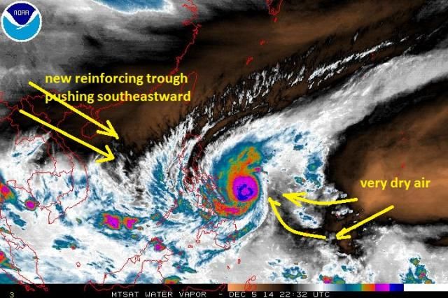
Is anyone noticing the very dry air getting pulled in on the southeastern side? This is great news for the Philippines because this is going to really weaken it even more before it makes landfall. Also, a new reinforcing trough over China is coming towards this from the northwest - a new push that will force a recurve. All of this of course is good news for the Philippines so let's hope it pans out.

0 likes
-
xtyphooncyclonex
- Category 5
- Posts: 3891
- Age: 24
- Joined: Sat Dec 08, 2012 9:07 am
- Location: Cebu City
- Contact:
Re: WPAC: HAGUPIT - Typhoon
Only a tad north, but I think center is at 12.1N.
22W HAGUPIT 141206 0000 12.2N 127.4E WPAC 120 933
Here is JMA
TY 1422 (HAGUPIT)
Issued at 00:50 UTC, 6 December 2014
<Analyses at 06/00 UTC>
Scale -
Intensity Very Strong
Center position N12°05'(12.1°)
E127°25'(127.4°)
Direction and speed of movement W 10km/h(6kt)
Central pressure 925hPa
Maximum wind speed near the center 50m/s(100kt)
Maximum wind gust speed 70m/s(140kt)
Area of 50kt winds or more ALL110km(60NM)
Area of 30kt winds or more N500km(270NM)
S280km(150NM)
0 likes
REMINDER: My opinions that I, or any other NON Pro-Met in this forum, are unofficial. Please do not take my opinions as an official forecast and warning. I am NOT a meteorologist. Following my forecasts blindly may lead to false alarm, danger and risk if official forecasts from agencies are ignored.
-
cycloneye
- Admin
- Posts: 149387
- Age: 69
- Joined: Thu Oct 10, 2002 10:54 am
- Location: San Juan, Puerto Rico
Re: WPAC: HAGUPIT - Typhoon
TPPN11 PGTW 060011
A. SUPER TYPHOON 22W (HAGUPIT)
B. 05/2332Z
C. 12.25N
D. 127.42E
E. THREE/MTSAT
F. T6.0/6.0/S0.0/24HRS STT: S0.0/03HRS
G. IR/EIR
H. REMARKS: 09A/PBO RAGGED EYE/ANMTN. LG EYE SURROUNDED BY
WHITE YIELDS A DT OF 6.0. MET AND PT AGREE; DBO DT.
I. ADDITIONAL POSITIONS:
05/2025Z 12.05N 127.87E SSMS
LONG
A. SUPER TYPHOON 22W (HAGUPIT)
B. 05/2332Z
C. 12.25N
D. 127.42E
E. THREE/MTSAT
F. T6.0/6.0/S0.0/24HRS STT: S0.0/03HRS
G. IR/EIR
H. REMARKS: 09A/PBO RAGGED EYE/ANMTN. LG EYE SURROUNDED BY
WHITE YIELDS A DT OF 6.0. MET AND PT AGREE; DBO DT.
I. ADDITIONAL POSITIONS:
05/2025Z 12.05N 127.87E SSMS
LONG
0 likes
Visit the Caribbean-Central America Weather Thread where you can find at first post web cams,radars
and observations from Caribbean basin members Click Here
and observations from Caribbean basin members Click Here
-
ozonepete
- Professional-Met
- Posts: 4743
- Joined: Mon Sep 07, 2009 3:23 pm
- Location: From Ozone Park, NYC / Now in Brooklyn, NY
Re: WPAC: HAGUPIT - Typhoon
Ok. So JMA is 120 knots and the T6.0 numbers Luis just posted only support about 115 knots. Both are probably generous.
I also doubt its forward speed is even 6 knots.
I also doubt its forward speed is even 6 knots.
0 likes
-
xtyphooncyclonex
- Category 5
- Posts: 3891
- Age: 24
- Joined: Sat Dec 08, 2012 9:07 am
- Location: Cebu City
- Contact:
ozonepete wrote:Ok. So JMA is 120 knots and the T6.0 numbers Luis just posted only support about 115 knots. Both are probably generous.
JMA is 100 kts, meaning 114 kts. However, you may be right as Koba scale is 120 kts.
0 likes
REMINDER: My opinions that I, or any other NON Pro-Met in this forum, are unofficial. Please do not take my opinions as an official forecast and warning. I am NOT a meteorologist. Following my forecasts blindly may lead to false alarm, danger and risk if official forecasts from agencies are ignored.
-
xtyphooncyclonex
- Category 5
- Posts: 3891
- Age: 24
- Joined: Sat Dec 08, 2012 9:07 am
- Location: Cebu City
- Contact:
Re: WPAC: HAGUPIT - Typhoon
My unofficial track

Personal Forecast Disclaimer:
The posts in this forum are NOT official forecast and should not be used as such. They are just the opinion of the poster and may or may not be backed by sound meteorological data. They are NOT endorsed by any professional institution or storm2k.org. For official information, please refer to the NHC and NWS products.
0 likes
REMINDER: My opinions that I, or any other NON Pro-Met in this forum, are unofficial. Please do not take my opinions as an official forecast and warning. I am NOT a meteorologist. Following my forecasts blindly may lead to false alarm, danger and risk if official forecasts from agencies are ignored.
-
ozonepete
- Professional-Met
- Posts: 4743
- Joined: Mon Sep 07, 2009 3:23 pm
- Location: From Ozone Park, NYC / Now in Brooklyn, NY
Re:
xtyphooncyclonex wrote:ozonepete wrote:Ok. So JMA is 120 knots and the T6.0 numbers Luis just posted only support about 115 knots. Both are probably generous.
JMA is 100 kts, meaning 114 kts. However, you may be right as Koba scale is 120 kts.
Thanks for the correction my friend.
Btw you can see why the forward speed is becoming critical to the forecast. Personally what bothers me is that I haven't heard a single reference from JMA, JTWC or any other party about the upwelling problem. At its current very slow forward speed there is surely some pretty significant upwelling going on and it will get worse. This has to be causing some of the noticeable weakening we are seeing. And if this continues, the lower level steering winds, which are southwesterly, will sharply recurve it.
0 likes
-
xtyphooncyclonex
- Category 5
- Posts: 3891
- Age: 24
- Joined: Sat Dec 08, 2012 9:07 am
- Location: Cebu City
- Contact:
Re: Re:
ozonepete wrote:xtyphooncyclonex wrote:ozonepete wrote:Ok. So JMA is 120 knots and the T6.0 numbers Luis just posted only support about 115 knots. Both are probably generous.
JMA is 100 kts, meaning 114 kts. However, you may be right as Koba scale is 120 kts.
Thanks for the correction my friend.
Btw you can see why the forward speed is becoming critical to the forecast. Personally what bothers me is that I haven't heard a single reference from JMA, JTWC or any other party about the upwelling problem. At its current very slow forward speed there is surely some pretty significant upwelling going on and it will get worse. This has to be causing some of the noticeable weakening we are seeing. And if this continues, the lower level steering winds, which are southwesterly, will sharply recurve it.
So where do you think the first landfall will be?
And how strong the winds would be in Cebu City?
0 likes
REMINDER: My opinions that I, or any other NON Pro-Met in this forum, are unofficial. Please do not take my opinions as an official forecast and warning. I am NOT a meteorologist. Following my forecasts blindly may lead to false alarm, danger and risk if official forecasts from agencies are ignored.
Re: WPAC: HAGUPIT - Typhoon
This is in no way, shape, or form, going to recurve or be steered by the low level winds.
This is going nearly due west through the Philippines, just as has been forecast for the past 4 days
This is going nearly due west through the Philippines, just as has been forecast for the past 4 days
0 likes
-
dexterlabio
- Category 5
- Posts: 3505
- Joined: Sat Oct 24, 2009 11:50 pm
Re: WPAC: HAGUPIT - Typhoon
A slow moving typhoon is never a good thing in the Philippines.  Only good thing is that further upwelling will reduce its wind power.
Only good thing is that further upwelling will reduce its wind power.
0 likes
Personal Forecast Disclaimer:
The posts in this forum are NOT official forecast and should not be used as such. They are just the opinion of the poster and may or may not be backed by sound meteorological data. They are NOT endorsed by any professional institution or storm2k.org. For official information, please refer to the NHC and NWS products.
The posts in this forum are NOT official forecast and should not be used as such. They are just the opinion of the poster and may or may not be backed by sound meteorological data. They are NOT endorsed by any professional institution or storm2k.org. For official information, please refer to the NHC and NWS products.
Who is online
Users browsing this forum: No registered users and 8 guests