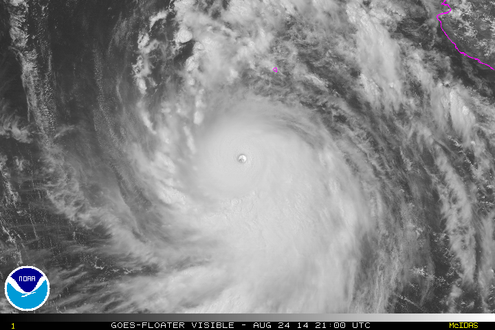
EPAC: MARIE - Post-Tropical
Moderator: S2k Moderators
- Yellow Evan
- Professional-Met

- Posts: 16240
- Age: 27
- Joined: Fri Jul 15, 2011 12:48 pm
- Location: Henderson, Nevada/Honolulu, HI
- Contact:
-
supercane4867
- Category 5

- Posts: 4966
- Joined: Wed Nov 14, 2012 10:43 am
Re: EPAC: MARIE - Hurricane
Not the most excited discussion for Cat.5 Marie, where is Stewart and Avila when we need them? 
0 likes
- Kingarabian
- S2K Supporter

- Posts: 16364
- Joined: Sat Aug 08, 2009 3:06 am
- Location: Honolulu, Hawaii
- Yellow Evan
- Professional-Met

- Posts: 16240
- Age: 27
- Joined: Fri Jul 15, 2011 12:48 pm
- Location: Henderson, Nevada/Honolulu, HI
- Contact:
Re: EPAC: MARIE - Hurricane
supercane4867 wrote:Not the most excited discussion for Cat.5 Marie, where is Stewart and Avila when we need them?
The most boring actually. Reminded me of some of the bland 90s ones.
0 likes
- Yellow Evan
- Professional-Met

- Posts: 16240
- Age: 27
- Joined: Fri Jul 15, 2011 12:48 pm
- Location: Henderson, Nevada/Honolulu, HI
- Contact:
Re:
CrazyC83 wrote:To get stronger without Recon, need to find some T7.5's somewhere. What does it take for a 7.5?
The eye would have to warm. That's all.
0 likes
-
WeatherGuesser
- Category 5

- Posts: 2672
- Joined: Tue Jun 29, 2010 6:46 am
Re:
WeatherGuesser wrote:When was the last H5 in either EPAC or ATL?
Celia was the last cat 5 in the whem, epac storm 2010. Felix was the last cat 5 in ATL 2007.
0 likes
The above post and any post by Ntxw is NOT an official forecast and should not be used as such. It is just the opinion of the poster and may or may not be backed by sound meteorological data. It is NOT endorsed by any professional institution including Storm2k. For official information, please refer to NWS products.
- Yellow Evan
- Professional-Met

- Posts: 16240
- Age: 27
- Joined: Fri Jul 15, 2011 12:48 pm
- Location: Henderson, Nevada/Honolulu, HI
- Contact:
Re:
WeatherGuesser wrote:When was the last H5 in either EPAC or ATL?
Celia 2010. Did so at the last min.

0 likes
- Kingarabian
- S2K Supporter

- Posts: 16364
- Joined: Sat Aug 08, 2009 3:06 am
- Location: Honolulu, Hawaii
-
supercane4867
- Category 5

- Posts: 4966
- Joined: Wed Nov 14, 2012 10:43 am
Re:
CrazyC83 wrote:To get stronger without Recon, need to find some T7.5's somewhere. What does it take for a 7.5?
Using EIR method the Cold Medium Gray has to completely wrap around the eye in order to achieve a data-T value of 7.5 or else the developing trend allows for a higher PT that can be based as FT

0 likes
-
WeatherGuesser
- Category 5

- Posts: 2672
- Joined: Tue Jun 29, 2010 6:46 am
Re:
Kingarabian wrote:Meanwhile in the Atlantic:
Nada.
-----------------
OK, so 4 years and 7 years. Interesting.
They are fairly rare.
0 likes
There you go MIGHTY MARIE!!!!
Yellow Evan wrote:It did it. OFFICIAL!!!!!!


Yes, you did it Marie!
0 likes
- Yellow Evan
- Professional-Met

- Posts: 16240
- Age: 27
- Joined: Fri Jul 15, 2011 12:48 pm
- Location: Henderson, Nevada/Honolulu, HI
- Contact:
Re: Re:
supercane4867 wrote:CrazyC83 wrote:To get stronger without Recon, need to find some T7.5's somewhere. What does it take for a 7.5?
Using EIR method the Cold Medium Gray has to completely wrap around the eye in order to achieve a data-T value of 7.5 or else the developing trend allows for a higher PT that can be based as FT
http://www.nrlmry.navy.mil/tcdat/tc14/E ... -918mb.jpg
It's hard to tell. Is the eye as warm as it could possibly get then? Because when the eye is WMG, W and CMG is the max you can go.
0 likes
-
supercane4867
- Category 5

- Posts: 4966
- Joined: Wed Nov 14, 2012 10:43 am
Re: Re:
Yellow Evan wrote:It's hard to tell. Is the eye as warm as it could possibly get then? Because when the eye is WMG, W and CMG is the max you can go.
The eye has acquired WMG status since this morning but with the cloud tops also warmed quite a bit I don't think it can reach T7.5
0 likes
-
HurricaneRyan
- Category 3

- Posts: 846
- Age: 32
- Joined: Sun Dec 05, 2010 3:05 pm
- Yellow Evan
- Professional-Met

- Posts: 16240
- Age: 27
- Joined: Fri Jul 15, 2011 12:48 pm
- Location: Henderson, Nevada/Honolulu, HI
- Contact:
UW - CIMSS
ADVANCED DVORAK TECHNIQUE
ADT-Version 8.2.1
Tropical Cyclone Intensity Algorithm
----- Current Analysis -----
Date : 24 AUG 2014 Time : 210000 UTC
Lat : 15:56:59 N Lon : 112:02:38 W
CI# /Pressure/ Vmax
7.1 / 914.5mb/143.0kt
Final T# Adj T# Raw T#
7.1 7.1 7.1
Estimated radius of max. wind based on IR : 18 km
Center Temp : +15.7C Cloud Region Temp : -73.5C
Scene Type : EYE
Positioning Method : RING/SPIRAL COMBINATION
Ocean Basin : EAST PACIFIC
Dvorak CI > MSLP Conversion Used : ATLANTIC
Tno/CI Rules : Constraint Limits : NO LIMIT
Weakening Flag : OFF
Rapid Dissipation Flag : OFF
C/K/Z MSLP Estimate Inputs :
- Average 34 knot radii : 202km
- Environmental MSLP : 1011mb
Satellite Name : GOES15
Satellite Viewing Angle : 32.3 degrees
0 likes
Re: EPAC: MARIE - Hurricane
This EPAC season has been very very interesting to watch, it has been even more interesting than the WPAC. Marie is beautiful, behold the 6th most intense EPAC hurricane on record (per central pressure):


0 likes
Who is online
Users browsing this forum: No registered users and 20 guests


