
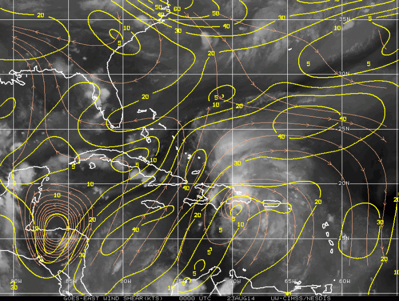
TheStormExpert wrote:NHC not buying the GFS and other models sudden westward shift.
http://i59.tinypic.com/eb3oqq.jpg
Remember that they also do not react to model shifts on just one run, they go by the trends most times.
Moderator: S2k Moderators
TheStormExpert wrote:NHC not buying the GFS and other models sudden westward shift.
http://i59.tinypic.com/eb3oqq.jpg
ronjon wrote:TheStormExpert wrote:NHC not buying the GFS and other models sudden westward shift.
http://i59.tinypic.com/eb3oqq.jpg
Of course, waiting on 00z runs to make any changes. They are conservative which is a good thing.


gatorcane wrote:WV loop showing the players unfolding that will dictate the future track of this invest which you can see at the very bottom right of image:

cycloneye wrote:Up to 80%-90%
TROPICAL WEATHER OUTLOOK
NWS NATIONAL HURRICANE CENTER MIAMI FL
800 PM EDT FRI AUG 22 2014
For the North Atlantic...Caribbean Sea and the Gulf of Mexico:
An Air Force Reserve Hurricane Hunter aircraft investigating the
area of disturbed weather near Puerto Rico and Hispaniola reported
winds of tropical storm force over the open waters north of those
islands. However, the aircraft data and surface observations
indicate that the system still lacks a well-defined surface
circulation. Another Air Force Reserve Hurricane Hunter aircraft is
scheduled to investigate the system on Saturday morning, if
necessary.
Showers and thunderstorms associated with the system are gradaully
becoming better organized, but the proximity of the system to
Hispaniola could limit development tonight. Conditions are expected
to become more conducive for development when the disturbance moves
near or over the southeastern Bahamas on Saturday. Gusty winds and
heavy rains are expected across Puerto Rico and the Virgin Islands
tonight, and over portions of Hispaniola and the southeastern and
central Bahamas tonight and Saturday. These heavy rains could cause
life-threatening flash floods and mudslides, especially in the
mountainous areas of Hispaniola and Puerto Rico. Interests in the
southeastern and central Bahamas should monitor the progress of this
disturbance, since tropical storm watches or warnings could be
required with little advance notice.
* Formation chance through 48 hours...high...80 percent.
* Formation chance through 5 days...high...90 percent.
$$
Forecaster Beven

NDG wrote:0z Best Track position, notice that it has not reached the 70th longitude.
AL, 96, 2014082300, , BEST, 0, 196N, 691W, 35, 1008,

TheStormExpert wrote:NHC not buying the GFS and other models sudden westward shift.
http://i59.tinypic.com/eb3oqq.jpg


gatorcane wrote:WV loop showing the players unfolding that will dictate the future track of this invest which you can see at the very bottom right of image:
Users browsing this forum: No registered users and 28 guests


