ATL: ARTHUR - Post-Tropical - Discussion

Moderator: S2k Moderators

Message
Author
User avatar
pgoss11
Category 2
Category 2
Posts: 702
Joined: Tue Sep 02, 2003 3:55 pm

Re:

#881 Postby pgoss11 » Tue Jul 01, 2014 4:58 pm

SeGaBob wrote:Is there a decent chance of this system getting big enough to give areas on the GA and SC coasts some rain even though it will be offshore a ways?

Our local met here in Charleston SC just said we could have some backlash rain and wind but as of right now thought the effects would be minimal.
0 likes   

hurricanekid416
Tropical Storm
Tropical Storm
Posts: 179
Joined: Wed Oct 24, 2012 2:43 pm

Re:

#882 Postby hurricanekid416 » Tue Jul 01, 2014 4:58 pm

NDG wrote:I don't know which one is more exciting, Arthur or the USA/Belgium game? We should had scored at the last minute, oh well.

Haha I'm watching both lol
0 likes   
Personal Forecast Disclaimer:
The posts in this forum are NOT official forecast and should not be used as such. They are just the opinion of the poster and may or may not be backed by sound meteorological data. They are NOT endorsed by any professional institution or storm2k.org. For official information, please refer to the NHC and NWS products.

SeGaBob

Re: Re:

#883 Postby SeGaBob » Tue Jul 01, 2014 5:02 pm

pgoss11 wrote:
SeGaBob wrote:Is there a decent chance of this system getting big enough to give areas on the GA and SC coasts some rain even though it will be offshore a ways?

Our local met here in Charleston SC just said we could have some backlash rain and wind but as of right now thought the effects would be minimal.


Our local met out of Savannah said just beach erosion and rip currents. I think it's still too early for them to be so sure.
0 likes   

xironman
S2K Supporter
S2K Supporter
Posts: 2522
Joined: Sun Jun 10, 2007 4:53 pm
Location: NoVA

Re: ATL: ARTHUR - Tropical Storm - Discussion

#884 Postby xironman » Tue Jul 01, 2014 5:02 pm

Aric Dunn wrote:ship report well to the ne where recon did not sample has sustained winds of 51kt


Looks like it has consolidated well since the environmental conditions got better.
0 likes   

Aric Dunn
Category 5
Category 5
Posts: 21238
Age: 42
Joined: Sun Sep 19, 2004 9:58 pm
Location: Ready for the Chase.
Contact:

#885 Postby Aric Dunn » Tue Jul 01, 2014 5:03 pm

There appears to a old vort to the nw... if thats the case eventually the new center is going to come back to the wes pretty abruptly.. later tonight..
0 likes   
Note: If I make a post that is brief. Please refer back to previous posts for the analysis or reasoning. I do not re-write/qoute what my initial post said each time.
If there is nothing before... then just ask :)

Space & Atmospheric Physicist, Embry-Riddle Aeronautical University,
I believe the sky is falling...

SeGaBob

#886 Postby SeGaBob » Tue Jul 01, 2014 5:05 pm

I'd estimate the actual intensity of the storm to be around 60-65 mph.


Personal Forecast Disclaimer:
The posts in this forum are NOT official forecast and should not be used as such. They are just the opinion of the poster and may or may not be backed by sound meteorological data. They are NOT endorsed by any professional institution or storm2k.org. For official information, please refer to the NHC and NWS products.
0 likes   

User avatar
chaser1
S2K Supporter
S2K Supporter
Posts: 5467
Age: 64
Joined: Sat Oct 15, 2005 5:59 pm
Location: Longwood, Fl

Re: ATL: ARTHUR - Tropical Storm - Discussion

#887 Postby chaser1 » Tue Jul 01, 2014 5:07 pm

Aric, i‘m seeing one thing on satellite that would depict a northeast motion....or another cyclonic moving eddy about to be spit out. How are you seeing motion as depicted by radar (am using a new tablet and need to figure how to download flash or java for radar)
0 likes   
Andy D

(For official information, please refer to the NHC and NWS products.)

User avatar
TheAustinMan
Category 5
Category 5
Posts: 1047
Age: 25
Joined: Mon Jul 08, 2013 4:26 pm
Location: United States
Contact:

#888 Postby TheAustinMan » Tue Jul 01, 2014 5:08 pm

It's long range radar, but we should be keeping an eye at the convective cell of this system over the next few hours...

Image
0 likes   
ImageImageImage
Treat my opinions with a grain of salt. For official information see your local weather service.

User avatar
hurricanefloyd5
Category 5
Category 5
Posts: 1659
Age: 44
Joined: Sun May 02, 2004 10:53 am
Location: Spartanburg
Contact:

Re: ATL: ARTHUR - Tropical Storm - Discussion

#889 Postby hurricanefloyd5 » Tue Jul 01, 2014 5:09 pm

Will it move westward closer to the coast?
0 likes   

Aric Dunn
Category 5
Category 5
Posts: 21238
Age: 42
Joined: Sun Sep 19, 2004 9:58 pm
Location: Ready for the Chase.
Contact:

Re: ATL: ARTHUR - Tropical Storm - Discussion

#890 Postby Aric Dunn » Tue Jul 01, 2014 5:09 pm

chaser1 wrote:Aric, i‘m seeing one thing on satellite that would depict a northeast motion....or another cyclonic moving eddy about to be spit out. How are you seeing motion as depicted by radar (am using a new tablet and need to figure how to download flash or java for radar)


im looking at both radar and sat.. yeah the new center (which the convection is following not spitting out) is moving the NNE while if you look at both radar and sat you can see a small vort approaching the coast.. I was trying to say that later on since they are rotating the new one will begin to move back in the direction of the coast.
0 likes   
Note: If I make a post that is brief. Please refer back to previous posts for the analysis or reasoning. I do not re-write/qoute what my initial post said each time.
If there is nothing before... then just ask :)

Space & Atmospheric Physicist, Embry-Riddle Aeronautical University,
I believe the sky is falling...

User avatar
hurricanefloyd5
Category 5
Category 5
Posts: 1659
Age: 44
Joined: Sun May 02, 2004 10:53 am
Location: Spartanburg
Contact:

Re: ATL: ARTHUR - Tropical Storm - Discussion

#891 Postby hurricanefloyd5 » Tue Jul 01, 2014 5:10 pm

AMZ111-020930-
ATLANTIC FROM 27N TO 31N W OF 77W-
605 PM EDT TUE JUL 1 2014

...HURRICANE WARNING...

.TONIGHT...TROPICAL STORM CONDITIONS. N OF 29N W OF 79W...E TO
SE WINDS 20 TO 25 KT...INCREASING TO 25 TO 30 KT LATE.
ELSEWHERE...SE TO S WINDS 35 TO 40 KT...INCREASING TO 45 TO
50 KT LATE. SEAS 10 TO 15 FT. SCATTERED SHOWERS AND ISOLATED
TSTMS.
.WED...TROPICAL STORM CONDITIONS EXPECTED. SE TO S WINDS 45 TO 50
KT...INCREASING TO 50 TO 55 KT LATE. SEAS 14 FT... BUILDING TO 17
FT LATE. SCATTERED SHOWERS AND ISOLATED TSTMS.
.WED NIGHT...TROPICAL STORM CONDITIONS EXPECTED. S TO SW WINDS
50 TO 55 KT. SEAS 16 TO 26 FT. SCATTERED SHOWERS AND ISOLATED
TSTMS.
.THU...TROPICAL STORM CONDITIONS EXPECTED. SW WINDS 55 TO 65 KT.
N OF 29N W OF 79W...SEAS 20 FT...SUBSIDING TO 14 FT LATE.
ELSEWHERE...SEAS 17 TO 27 FT. SCATTERED SHOWERS AND ISOLATED
TSTMS.
.THU NIGHT...TROPICAL STORM CONDITIONS POSSIBLE. SW WINDS 20 TO
25 KT...BECOMING S TO SW 15 TO 20 KT LATE. SEAS 8 TO
11 FT. SCATTERED SHOWERS AND ISOLATED TSTMS.
.FRI...S TO SW WINDS 15 TO 20 KT. SEAS 7 TO 10 FT.
.FRI NIGHT...S TO SW WINDS 10 TO 15 KT. SEAS 5 TO 7 FT.
.SAT...S TO SW WINDS 5 TO 10 KT. SEAS 4 TO 6 FT.
.SAT NIGHT...SE TO S WINDS 5 TO 10 KT. SEAS 3 TO 5 FT.
.SUN...SE TO S WINDS 5 TO 10 KT. SEAS 2 TO 4 FT.

$$
0 likes   

User avatar
viberama
Tropical Depression
Tropical Depression
Posts: 65
Age: 52
Joined: Mon Aug 01, 2011 7:36 pm
Location: Orlando, FL
Contact:

Re: ATL: ARTHUR - Tropical Storm - Discussion

#892 Postby viberama » Tue Jul 01, 2014 5:11 pm

If and when that blob of t-storms in the the S, SE and E quads wraps around....BAM!, off to the races. Everyone stay safe.
0 likes   
The following post is NOT an official forecast and should not be used as such. It is just my opinion and may or may not be backed by sound meteorological data. For Official Information please refer to the NHC and NWS products

TJRE
Tropical Storm
Tropical Storm
Posts: 188
Joined: Sun Jun 02, 2013 9:04 am
Location: New Jersey

Re: ATL: ARTHUR - Tropical Storm - Discussion

#893 Postby TJRE » Tue Jul 01, 2014 5:16 pm

Goes Science
SAT Shot
bet we have some real nice images this week.....


Image

Uploaded with ImageShack.us

http://goes.gsfc.nasa.gov/
0 likes   

User avatar
chaser1
S2K Supporter
S2K Supporter
Posts: 5467
Age: 64
Joined: Sat Oct 15, 2005 5:59 pm
Location: Longwood, Fl

Re: ATL: ARTHUR - Tropical Storm - Discussion

#894 Postby chaser1 » Tue Jul 01, 2014 5:19 pm

hurricanefloyd5 wrote:AMZ111-020930-
ATLANTIC FROM 27N TO 31N W OF 77W-
605 PM EDT TUE JUL 1 2014

...HURRICANE WARNING...

.TONIGHT...TROPICAL STORM CONDITIONS. N OF 29N W OF 79W...E TO
SE WINDS 20 TO 25 KT...INCREASING TO 25 TO 30 KT LATE.
ELSEWHERE...SE TO S WINDS 35 TO 40 KT...INCREASING TO 45 TO
50 KT LATE. SEAS 10 TO 15 FT. SCATTERED SHOWERS AND ISOLATED
TSTMS.
.WED...TROPICAL STORM CONDITIONS EXPECTED. SE TO S WINDS 45 TO 50
KT...INCREASING TO 50 TO 55 KT LATE. SEAS 14 FT... BUILDING TO 17
FT LATE. SCATTERED SHOWERS AND ISOLATED TSTMS.
.WED NIGHT...TROPICAL STORM CONDITIONS EXPECTED. S TO SW WINDS
50 TO 55 KT. SEAS 16 TO 26 FT. SCATTERED SHOWERS AND ISOLATED
TSTMS.
.THU...TROPICAL STORM CONDITIONS EXPECTED. SW WINDS 55 TO 65 KT.
N OF 29N W OF 79W...SEAS 20 FT...SUBSIDING TO 14 FT LATE.
ELSEWHERE...SEAS 17 TO 27 FT. SCATTERED SHOWERS AND ISOLATED
TSTMS.
.THU NIGHT...TROPICAL STORM CONDITIONS POSSIBLE. SW WINDS 20 TO
25 KT...BECOMING S TO SW 15 TO 20 KT LATE. SEAS 8 TO
11 FT. SCATTERED SHOWERS AND ISOLATED TSTMS.
.FRI...S TO SW WINDS 15 TO 20 KT. SEAS 7 TO 10 FT.
.FRI NIGHT...S TO SW WINDS 10 TO 15 KT. SEAS 5 TO 7 FT.
.SAT...S TO SW WINDS 5 TO 10 KT. SEAS 4 TO 6 FT.
.SAT NIGHT...SE TO S WINDS 5 TO 10 KT. SEAS 3 TO 5 FT.
.SUN...SE TO S WINDS 5 TO 10 KT. SEAS 2 TO 4 FT.

$$


WHAT?? Issued for "who"?? Marine interests?
0 likes   
Andy D

(For official information, please refer to the NHC and NWS products.)

User avatar
hurricanefloyd5
Category 5
Category 5
Posts: 1659
Age: 44
Joined: Sun May 02, 2004 10:53 am
Location: Spartanburg
Contact:

Re: ATL: ARTHUR - Tropical Storm - Discussion

#895 Postby hurricanefloyd5 » Tue Jul 01, 2014 5:20 pm

chaser1 wrote:
hurricanefloyd5 wrote:AMZ111-020930-
ATLANTIC FROM 27N TO 31N W OF 77W-
605 PM EDT TUE JUL 1 2014

...HURRICANE WARNING...

.TONIGHT...TROPICAL STORM CONDITIONS. N OF 29N W OF 79W...E TO
SE WINDS 20 TO 25 KT...INCREASING TO 25 TO 30 KT LATE.
ELSEWHERE...SE TO S WINDS 35 TO 40 KT...INCREASING TO 45 TO
50 KT LATE. SEAS 10 TO 15 FT. SCATTERED SHOWERS AND ISOLATED
TSTMS.
.WED...TROPICAL STORM CONDITIONS EXPECTED. SE TO S WINDS 45 TO 50
KT...INCREASING TO 50 TO 55 KT LATE. SEAS 14 FT... BUILDING TO 17
FT LATE. SCATTERED SHOWERS AND ISOLATED TSTMS.
.WED NIGHT...TROPICAL STORM CONDITIONS EXPECTED. S TO SW WINDS
50 TO 55 KT. SEAS 16 TO 26 FT. SCATTERED SHOWERS AND ISOLATED
TSTMS.
.THU...TROPICAL STORM CONDITIONS EXPECTED. SW WINDS 55 TO 65 KT.
N OF 29N W OF 79W...SEAS 20 FT...SUBSIDING TO 14 FT LATE.
ELSEWHERE...SEAS 17 TO 27 FT. SCATTERED SHOWERS AND ISOLATED
TSTMS.
.THU NIGHT...TROPICAL STORM CONDITIONS POSSIBLE. SW WINDS 20 TO
25 KT...BECOMING S TO SW 15 TO 20 KT LATE. SEAS 8 TO
11 FT. SCATTERED SHOWERS AND ISOLATED TSTMS.
.FRI...S TO SW WINDS 15 TO 20 KT. SEAS 7 TO 10 FT.
.FRI NIGHT...S TO SW WINDS 10 TO 15 KT. SEAS 5 TO 7 FT.
.SAT...S TO SW WINDS 5 TO 10 KT. SEAS 4 TO 6 FT.
.SAT NIGHT...SE TO S WINDS 5 TO 10 KT. SEAS 3 TO 5 FT.
.SUN...SE TO S WINDS 5 TO 10 KT. SEAS 2 TO 4 FT.

$$


WHAT?? Issued for "who"?? Marine interests?


Yes marine interest
0 likes   

User avatar
TheAustinMan
Category 5
Category 5
Posts: 1047
Age: 25
Joined: Mon Jul 08, 2013 4:26 pm
Location: United States
Contact:

#896 Postby TheAustinMan » Tue Jul 01, 2014 5:23 pm

0 likes   
ImageImageImage
Treat my opinions with a grain of salt. For official information see your local weather service.

User avatar
weathernerdguy
Tropical Storm
Tropical Storm
Posts: 188
Age: 23
Joined: Wed Jul 10, 2013 8:44 pm

#897 Postby weathernerdguy » Tue Jul 01, 2014 5:25 pm

i see the vertices on radar are finally getting rejected from the convection i see
0 likes   
The posts in this forum are NOT official forecast and should not be used as such. They are just the opinion of the poster and may or may not be backed by sound meteorological data. They are NOT endorsed by any professional institution or storm2k.org. For official information, please refer to the NHC and NWS products

Pack11
Tropical Wave
Tropical Wave
Posts: 8
Joined: Tue Sep 16, 2003 9:10 pm
Location: Hatteras Island, NC

Re: ATL: ARTHUR - Tropical Storm - Discussion

#898 Postby Pack11 » Tue Jul 01, 2014 5:25 pm

Looks like I picked a bad week to move to Hatteras Island....
0 likes   

ozonepete
Professional-Met
Professional-Met
Posts: 4743
Joined: Mon Sep 07, 2009 3:23 pm
Location: From Ozone Park, NYC / Now in Brooklyn, NY

Re: ATL: ARTHUR - Tropical Storm - Discussion

#899 Postby ozonepete » Tue Jul 01, 2014 5:26 pm

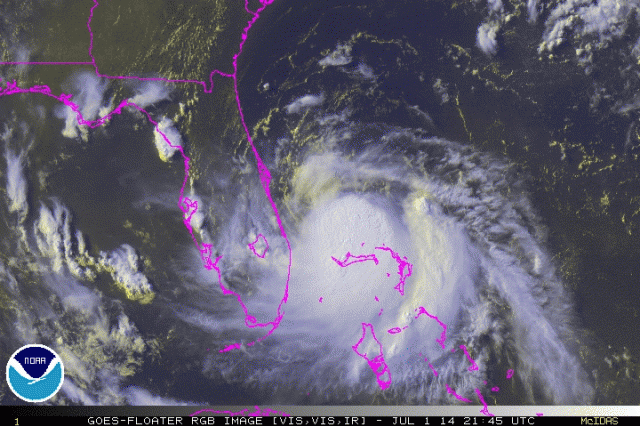
Wow, very impressive strengthening and visible presentation and it came on so rapidly just in the last few hours. This looks like it's really ready to take off.

Image
0 likes   

User avatar
JtSmarts
S2K Supporter
S2K Supporter
Posts: 1437
Age: 39
Joined: Thu Jul 10, 2003 1:29 pm
Location: Columbia, South Carolina

Re: ATL: ARTHUR - Tropical Storm - Discussion

#900 Postby JtSmarts » Tue Jul 01, 2014 5:29 pm

ozonepete wrote:Wow, very impressive strengthening and visible presentation and it came on so rapidly just in the last few hours. This looks like it's really ready to take off.

Image


I agree! It's always so fascinating to watch tc generate from just a mass of clouds to an organized system, one of the best parts of watching tropical storms.
0 likes   


Return to “2014”

Who is online

Users browsing this forum: No registered users and 1 guest