ATL: INVEST 90L

Moderator: S2k Moderators

Message
Author
Meow

ATL: INVEST 90L

#1 Postby Meow » Wed Jun 04, 2014 8:15 am

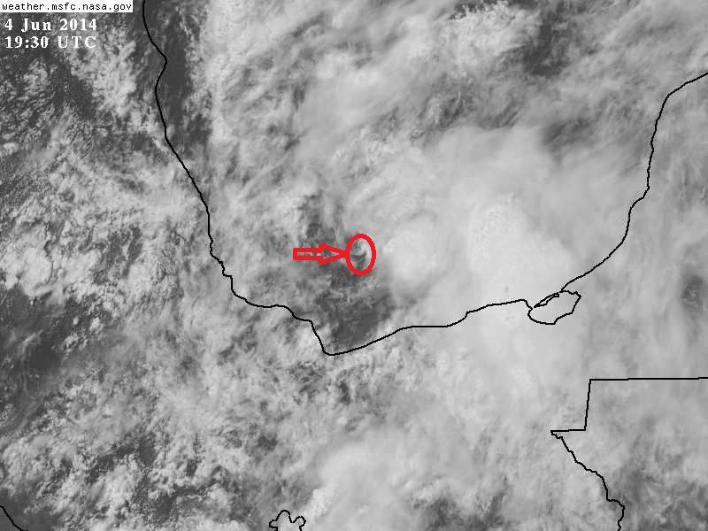
Image

This is the first disturbance in the North Atlantic in 2014, which is currently very close to Boris.

90L.INVEST.20kts.1006mb.18.9N.94.4W

90L INVEST 140604 0600 18.9N 94.4W ATL 20 1006
90L INVEST 140604 0000 18.9N 94.4W ATL 20 1006
90L INVEST 140603 1800 18.9N 94.4W ATL 20 1006
90L INVEST 140603 1200 18.8N 94.4W ATL 20 1006
0 likes   

User avatar
NDG
S2K Supporter
S2K Supporter
Posts: 14933
Joined: Sun Jul 09, 2006 10:14 pm
Location: Orlando, FL

#2 Postby NDG » Wed Jun 04, 2014 8:35 am

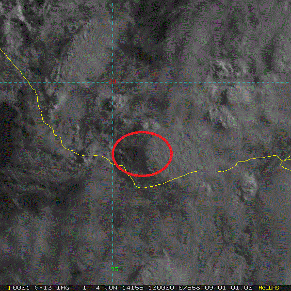
Zoomed in area of 90L, very close to the coast.

Image
0 likes   

User avatar
cycloneye
Admin
Admin
Posts: 139144
Age: 67
Joined: Thu Oct 10, 2002 10:54 am
Location: San Juan, Puerto Rico

Re: ATL: INVEST 90L --- 10% / 20%

#3 Postby cycloneye » Wed Jun 04, 2014 10:37 am

Here is Dr Jeff Masters discussion about 90L:

Atlantic's first "Invest" of 2014 forms in Gulf of Mexico
The National Hurricane Center's first area of interest in the Atlantic for 2014 was designated on Wednesday morning in the Southern Gulf of Mexico's Bay of Campeche. Invest 90L is nearly stationary, but satellite loops show that 90L is kicking up some heavy thunderstorms along the Mexican coast. Wind shear as diagnosed by the 8 am EDT Wednesday run of the SHIPS model was high, 20 - 25 knots, and wind shear is expected to stay high over the Bay of Campeche through Saturday. By Sunday, wind shear is predicted to drop, and 90L may have a better chance to develop then. Boris' remnants will be working their way northwards and arrive in the Bay of Campeche over the weekend, and the extra spin and moisture from Boris have the potential to aid development of 90L. However, a band of high wind shear associated with strong upper-level winds from the subtropical jet stream is predicted to lie over the Central Gulf of Mexico, and these winds may interfere with development. Sea surface temperatures (SSTs) in the Southern Gulf of Mexico are about 28°, which is about 0.5° above average. These warm waters do not extend to great depth, and the total heat energy available to intensify a potential storm is rather low. SSTs cool quickly as one goes to the north, are a marginal 26°C in the Central Gulf of Mexico. None of the reliable genesis forecast models predict that 90L will develop over the next five days. In their 8 am EDT Wednesday Tropical Weather Outlook, NHC gave 2-day odds of development of 10% and 5-day odds of 20%. I put these odds at 20% and 30%, respectively, given the propensity of the Bay of Campeche to spin up tropical cyclones in recent years.
0 likes   
Visit the Caribbean-Central America Weather Thread where you can find at first post web cams,radars
and observations from Caribbean basin members Click Here

OuterBanker
S2K Supporter
S2K Supporter
Posts: 1704
Joined: Wed Feb 26, 2003 10:53 am
Location: Nags Head, NC
Contact:

#4 Postby OuterBanker » Wed Jun 04, 2014 10:53 am

With the upper level winds and marginal sst's maybe Enron would be a better "invest".
0 likes   

Stormcenter
S2K Supporter
S2K Supporter
Posts: 6617
Joined: Wed Sep 03, 2003 11:27 am
Location: Houston, TX

Re:

#5 Postby Stormcenter » Wed Jun 04, 2014 10:54 am

OuterBanker wrote:With the upper level winds and marginal sst's maybe Enron would be a better "invest".
:lol:
0 likes   

davidiowx
Category 1
Category 1
Posts: 386
Joined: Tue Sep 10, 2013 11:07 am
Location: Richmond, TX

Re:

#6 Postby davidiowx » Wed Jun 04, 2014 11:16 am

OuterBanker wrote:With the upper level winds and marginal sst's maybe Enron would be a better "invest".


Gave me a nice chuckle :D
0 likes   

User avatar
StormingB81
S2K Supporter
S2K Supporter
Posts: 5676
Age: 42
Joined: Thu Aug 27, 2009 1:45 am
Location: Rockledge, Florida

#7 Postby StormingB81 » Wed Jun 04, 2014 11:21 am

One brings it to Texas....one Brings it to Florida......please let us not have a Debby fight again...Remember Debby 2012..The question where is it going to go for days....the models couldn't agree
0 likes   

User avatar
northjaxpro
S2K Supporter
S2K Supporter
Posts: 8900
Joined: Mon Sep 27, 2010 11:21 am
Location: Jacksonville, FL

Re:

#8 Postby northjaxpro » Wed Jun 04, 2014 11:27 am

StormingB81 wrote:One brings it to Texas....one Brings it to Florida......please let us not have a Debby fight again...Remember Debby 2012..The question where is it going to go for days....the models couldn't agree


Oh, yeah, we all can never forget Debby I can assure you. Debby decided to come my way and drench us with 14 inches of rain back in June 2012.

As for 90L, I am just going to take a wait and see position. If we get development, there is also the possibility that 90L could stay in the vicinity of the BOC for a couple of days or so as well. Lots of uncertainty with this system, so we just have to watch as always.
0 likes   
NEVER, EVER SAY NEVER in the tropics and weather in general, and most importantly, with life itself!!

________________________________________________________________________________________

Fay 2008 Beryl 2012 Debby 2012 Colin 2016 Hermine 2016 Julia 2016 Matthew 2016 Irma 2017 Dorian 2019

User avatar
TheProfessor
Professional-Met
Professional-Met
Posts: 3505
Age: 27
Joined: Tue Dec 03, 2013 10:56 am
Location: Wichita, Kansas

ATL: INVEST 90L --- 20% / 20%

#9 Postby TheProfessor » Wed Jun 04, 2014 11:33 am

StormingB81 wrote:One brings it to Texas....one Brings it to Florida......please let us not have a Debby fight again...Remember Debby 2012..The question where is it going to go for days....the models couldn't agree


Yeah, I was at a weather camp at Jackson state college, and they would of had to release us after 2 days if Debby had hit Mississippi like some of the models were predicting. But, yeah, if the storm does develop, we could be looking at another Debby situation here. And if I remember correctly the same happened with Isaac, During the same year, the models were split between Tampa and an Alabama land fall, and it ended up hitting Louisiana instead. Go figure. :roll:
0 likes   
An alumnus of The Ohio State University.

Your local National Weather Service office is your best source for weather information.

User avatar
cycloneye
Admin
Admin
Posts: 139144
Age: 67
Joined: Thu Oct 10, 2002 10:54 am
Location: San Juan, Puerto Rico

Re: ATL: INVEST 90L --- 20% / 20%

#10 Postby cycloneye » Wed Jun 04, 2014 12:45 pm

Small change in the movement part and 20% in 48 hours.

TROPICAL WEATHER OUTLOOK
NWS NATIONAL HURRICANE CENTER MIAMI FL
200 PM EDT WED JUN 4 2014

For the North Atlantic...Caribbean Sea and the Gulf of Mexico:

A complex low pressure area centered over the southern Bay of
Campeche is producing disorganized showers and thunderstorms over a
large portion of the southwestern Gulf of Mexico and southeastern
Mexico. Strong upper-level winds will likely inhibit significant
development of this system during the next couple of days before it
moves inland over eastern Mexico by Saturday. However, this
disturbance has the potential to produce extremely heavy rains and
life-threatening flash floods and mudslides during the next few days
over portions of southeastern Mexico.
* Formation chance through 48 hours...low...20 percent
* Formation chance through 5 days...low...20 percent

$$
Forecaster Blake
0 likes   
Visit the Caribbean-Central America Weather Thread where you can find at first post web cams,radars
and observations from Caribbean basin members Click Here

User avatar
wxman57
Moderator-Pro Met
Moderator-Pro Met
Posts: 22482
Age: 66
Joined: Sat Jun 21, 2003 8:06 pm
Location: Houston, TX (southwest)

Re: ATL: INVEST 90L --- 20% / 20%

#11 Postby wxman57 » Wed Jun 04, 2014 1:11 pm

12Z Euro moves a very weak (barely discernible) low into Mexico in 36 hrs. GFS dissipates it in place within 120 hrs but develops another weak low over the NE Yucatan in 7-8 days. Not much model support for development. However, whenever we get thunderstorms over the BoC or NW Caribbean/southern Gulf this time of year there is at least some chance of development. I'm still thinking a 40%-50% chance of a TD or weak/sheared TS in the next 5-10 days.
0 likes   

User avatar
cycloneye
Admin
Admin
Posts: 139144
Age: 67
Joined: Thu Oct 10, 2002 10:54 am
Location: San Juan, Puerto Rico

Re: ATL: INVEST 90L --- 20% / 20%

#12 Postby cycloneye » Wed Jun 04, 2014 1:30 pm

AL, 90, 2014060418, , BEST, 0, 187N, 944W, 20, 1006, DB
0 likes   
Visit the Caribbean-Central America Weather Thread where you can find at first post web cams,radars
and observations from Caribbean basin members Click Here

User avatar
NDG
S2K Supporter
S2K Supporter
Posts: 14933
Joined: Sun Jul 09, 2006 10:14 pm
Location: Orlando, FL

Re: ATL: INVEST 90L --- 20% / 20%

#13 Postby NDG » Wed Jun 04, 2014 3:10 pm

I am noticing a tight little circulation on the HD vis satellite loop, not sure if it is all the way down to the surface or if it is just a dying eddie. Time will tell I guess.

Image
0 likes   

User avatar
SouthDadeFish
Professional-Met
Professional-Met
Posts: 2835
Joined: Thu Sep 23, 2010 2:54 pm
Location: Miami, FL
Contact:

#14 Postby SouthDadeFish » Wed Jun 04, 2014 3:12 pm

This disturbance has a window for development if it can remain in the BoC long enough. Waters are warm enough to support TC formation and the atmosphere is very moist as evidenced by this sounding:

http://weather.uwyo.edu/upperair/bimages/2014060412.76692.skewt.parc.gif

If 90L does develop a decent surface circulation center, it would have a great outflow jet with the position of the subtropical jet to its north. I would put the long-term odds of development closer to 30-40% rather than the 20% currently shown by the NHC, but that's just me.
0 likes   

User avatar
MGC
S2K Supporter
S2K Supporter
Posts: 5792
Joined: Sun Mar 23, 2003 9:05 pm
Location: Pass Christian MS, or what is left.

Re: ATL: INVEST 90L --- 20% / 20%

#15 Postby MGC » Wed Jun 04, 2014 3:46 pm

Yep, sure does look like some spin down in the BOC......MGC
0 likes   

User avatar
Nimbus
Category 5
Category 5
Posts: 4928
Joined: Mon Jul 19, 2004 10:54 am

#16 Postby Nimbus » Wed Jun 04, 2014 3:53 pm

The upper level winds from the jetstream north of Texas don't appear to be dropping south yet. The model disparity is probably due to time of development, so that should clear up if this develops soon.

Interesting eddy but its getting some sheared at the moment.
0 likes   

User avatar
Evil Jeremy
S2K Supporter
S2K Supporter
Posts: 5459
Age: 30
Joined: Mon Apr 10, 2006 2:10 pm
Location: Los Angeles, CA

Re: ATL: INVEST 90L --- 20% / 20%

#17 Postby Evil Jeremy » Wed Jun 04, 2014 4:32 pm

90L is looking better this evening than this morning. Defiantly healthy rotation, and I also see the distinct eddy. I'm also impressed by the outflow this system is getting. I think the NHC will bump both percentages up to 30% tonight.

Looking at the CIMSS Vorticity charts, the energy from Boris seems to have made it's way into the BoC over the past 9 hours:

18z: http://imageshack.com/a/img835/6246/4r7v.gif
15z: http://imageshack.com/a/img842/9949/sk82.gif
12z: http://imageshack.com/a/img839/7886/isj.gif
0 likes   
Frances 04 / Jeanne 04 / Katrina 05 / Wilma 05 / Fay 08 / Debby 12 / Andrea 13 / Colin 16 / Hermine 16 / Matthew 16 / Irma 17

User avatar
Evil Jeremy
S2K Supporter
S2K Supporter
Posts: 5459
Age: 30
Joined: Mon Apr 10, 2006 2:10 pm
Location: Los Angeles, CA

#18 Postby Evil Jeremy » Wed Jun 04, 2014 5:21 pm

That eddy is starting to look like it's more than just an eddy to me...

http://www.ssd.noaa.gov/goes/east/gmex/flash-rgb.html
0 likes   
Frances 04 / Jeanne 04 / Katrina 05 / Wilma 05 / Fay 08 / Debby 12 / Andrea 13 / Colin 16 / Hermine 16 / Matthew 16 / Irma 17

USTropics
Category 5
Category 5
Posts: 2414
Joined: Sun Aug 12, 2007 3:45 am
Location: Florida State University

Re: ATL: INVEST 90L --- 20% / 20%

#19 Postby USTropics » Wed Jun 04, 2014 5:22 pm

Last 10 visible frames animated:

Image
0 likes   

User avatar
ronjon
Category 5
Category 5
Posts: 4671
Joined: Fri Aug 19, 2005 5:17 pm
Location: Hernando Beach, FL

Re: ATL: INVEST 90L --- 20% / 20%

#20 Postby ronjon » Wed Jun 04, 2014 6:17 pm

I see the rather broad CC circulation. Whatever happens down there, its not going anywhere anytime soon. Look for it to meander the next 2-3 days.
0 likes   


Return to “2014”

Who is online

Users browsing this forum: No registered users and 55 guests