EPAC: ELIDA - Post-Tropical

Moderator: S2k Moderators

Message
Author
User avatar
NDG
S2K Supporter
S2K Supporter
Posts: 14933
Joined: Sun Jul 09, 2006 10:14 pm
Location: Orlando, FL

Re: EPAC: ELIDA - Tropical Storm

#81 Postby NDG » Tue Jul 01, 2014 10:42 am

Hurricane_Luis wrote:Could up-welling be the source of weakening? or is it the shear.


It is the shear which was analyzed earlier at 25-30 knots from the outflow from the other TS.

Its LLC has gone almost naked:

Image
0 likes   

hurricanes1234
Category 5
Category 5
Posts: 2903
Joined: Sat Jul 28, 2012 6:19 pm
Location: Trinidad and Tobago

#82 Postby hurricanes1234 » Tue Jul 01, 2014 1:38 pm

I have two words for Elida right now: a mess!
:lol:
0 likes   
PLEASE NOTE: With the exception of information from weather agencies that I may copy and paste here, my posts will NEVER be official, since I am NOT a meteorologist. They are solely my amateur opinion, and may or may not be accurate. Therefore, please DO NOT use them as official details, particularly when making important decisions. Thank you.

hurricanes1234
Category 5
Category 5
Posts: 2903
Joined: Sat Jul 28, 2012 6:19 pm
Location: Trinidad and Tobago

#83 Postby hurricanes1234 » Tue Jul 01, 2014 2:28 pm

Just barely a tropical storm on 18:00 Best Track. I wouldn't be too surprised if this drops to tropical depression status in the near future.

05E ELIDA 140701 1800 17.3N 104.0W EPAC 35 1005
0 likes   
PLEASE NOTE: With the exception of information from weather agencies that I may copy and paste here, my posts will NEVER be official, since I am NOT a meteorologist. They are solely my amateur opinion, and may or may not be accurate. Therefore, please DO NOT use them as official details, particularly when making important decisions. Thank you.

User avatar
cycloneye
Admin
Admin
Posts: 139085
Age: 67
Joined: Thu Oct 10, 2002 10:54 am
Location: San Juan, Puerto Rico

Re: EPAC: ELIDA - Tropical Storm

#84 Postby cycloneye » Tue Jul 01, 2014 3:41 pm

TROPICAL STORM ELIDA DISCUSSION NUMBER 6
NWS NATIONAL HURRICANE CENTER MIAMI FL EP052014
200 PM PDT TUE JUL 01 2014

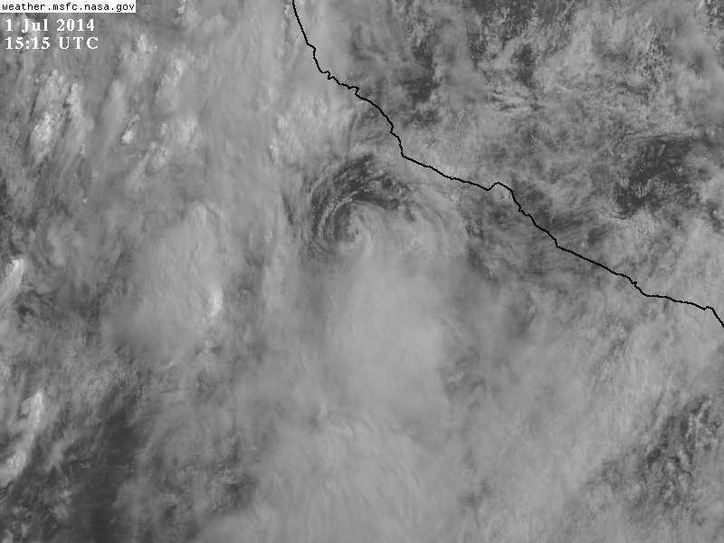
Strong northwesterly wind shear persists over Elida, and the
cyclone has become a tight swirl of low clouds devoid of deep
convection. Satellite intensity estimates continue to decrease, and
on this basis, the initial intensity has been lowered to 35 knots.
These winds are probably confined to a small area to the north and
east of the center. Global models indicate that the shear will
continue and, in fact, most of them weaken Elida to a low or a
trough in a few days. The NHC forecast is along the line of such
models.

Elida continues to be trapped in very weak steering currents, and
it has been drifting southeastward during the past several hours.
The steering flow is forecast by global models to remain weak during
the next day or two, and little motion is anticipated during that
period. A ridge is forecast to develop over Mexico beyond 3 days,
and this pattern should force Elida or its remnants to begin moving
slowly westward away from Mexico. This is consistent with the
multi-model consensus trend.

The government of Mexico has discontinued the tropical storm
warning, however, a few strong squalls could still affect the
coast during the next 12 to 24 hours.


FORECAST POSITIONS AND MAX WINDS

INIT 01/2100Z 17.2N 103.9W 35 KT 40 MPH
12H 02/0600Z 17.0N 103.8W 30 KT 35 MPH
24H 02/1800Z 16.8N 103.9W 30 KT 35 MPH
36H 03/0600Z 16.9N 104.1W 25 KT 30 MPH
48H 03/1800Z 17.0N 104.5W 25 KT 30 MPH
72H 04/1800Z 17.0N 106.5W 20 KT 25 MPH...POST-TROP/REMNT LOW
96H 05/1800Z 17.0N 108.0W 20 KT 25 MPH...POST-TROP/REMNT LOW
120H 06/1800Z 17.0N 111.0W 20 KT 25 MPH...POST-TROP/REMNT LOW

$$
Forecaster Avila
0 likes   
Visit the Caribbean-Central America Weather Thread where you can find at first post web cams,radars
and observations from Caribbean basin members Click Here

User avatar
Yellow Evan
Professional-Met
Professional-Met
Posts: 15952
Age: 25
Joined: Fri Jul 15, 2011 12:48 pm
Location: Henderson, Nevada/Honolulu, HI
Contact:

#85 Postby Yellow Evan » Tue Jul 01, 2014 3:48 pm

I doubt it'll survive the shear.
0 likes   

hurricanes1234
Category 5
Category 5
Posts: 2903
Joined: Sat Jul 28, 2012 6:19 pm
Location: Trinidad and Tobago

Re:

#86 Postby hurricanes1234 » Tue Jul 01, 2014 4:07 pm

Yellow Evan wrote:I doubt it'll survive the shear.


Already becoming a swirl. I personally don't see this surviving much longer. Probably a depression by 3:00 tomorrow.
0 likes   
PLEASE NOTE: With the exception of information from weather agencies that I may copy and paste here, my posts will NEVER be official, since I am NOT a meteorologist. They are solely my amateur opinion, and may or may not be accurate. Therefore, please DO NOT use them as official details, particularly when making important decisions. Thank you.

hurricanes1234
Category 5
Category 5
Posts: 2903
Joined: Sat Jul 28, 2012 6:19 pm
Location: Trinidad and Tobago

#87 Postby hurricanes1234 » Tue Jul 01, 2014 6:58 pm

I'd be surprised if this makes it to Thursday as anything but a 30 mph depression or remnant low.

Personal Forecast Disclaimer:
The posts in this forum are NOT official forecast and should not be used as such. They are just the opinion of the poster and may or may not be backed by sound meteorological data. They are NOT endorsed by any professional institution or storm2k.org. For official information, please refer to the NHC and NWS products.
0 likes   
PLEASE NOTE: With the exception of information from weather agencies that I may copy and paste here, my posts will NEVER be official, since I am NOT a meteorologist. They are solely my amateur opinion, and may or may not be accurate. Therefore, please DO NOT use them as official details, particularly when making important decisions. Thank you.

User avatar
cycloneye
Admin
Admin
Posts: 139085
Age: 67
Joined: Thu Oct 10, 2002 10:54 am
Location: San Juan, Puerto Rico

Re: EPAC: ELIDA - Tropical Depression

#88 Postby cycloneye » Tue Jul 01, 2014 9:59 pm

TROPICAL DEPRESSION ELIDA DISCUSSION NUMBER 7
NWS NATIONAL HURRICANE CENTER MIAMI FL EP052014
800 PM PDT TUE JUL 01 2014

Elida remains a tight swirl of low clouds devoid of any deep
convection. The initial intensity has been lowered to 30 kt,
close to a blend of the latest T/CI numbers from TAFB. Strong
northwesterly shear over Elida should continue to weaken the
system. Model guidance is in good agreement on this solution,
and the new NHC intensity prediction is very close to the previous
one. The only significant change is to show remnant low status
within 24 hours. Given the lack of convection, however,
Elida could become a remnant low even sooner than forecast.

Elida is moving a little faster toward the southeast this evening -
roughly 135/3 - an unusual motion for an eastern Pacific cyclone
in July. The depression or its remnants will likely move
southward by late tomorrow, then westward by Thursday due to a
building low-level ridge over the eastern Pacific. Model guidance
has shifted southward on this cycle, and the NHC forecast is moved
in that direction. The small cyclone should degenerate into a
trough in 3-4 days, which is in line with the global models.


FORECAST POSITIONS AND MAX WINDS

INIT 02/0300Z 17.0N 103.4W 30 KT 35 MPH
12H 02/1200Z 16.7N 103.2W 25 KT 30 MPH
24H 03/0000Z 16.4N 103.3W 20 KT 25 MPH...POST-TROP/REMNT LOW
36H 03/1200Z 16.2N 103.6W 20 KT 25 MPH...POST-TROP/REMNT LOW
48H 04/0000Z 16.1N 104.5W 20 KT 25 MPH...POST-TROP/REMNT LOW
72H 05/0000Z 16.5N 107.0W 15 KT 15 MPH...POST-TROP/REMNT LOW
96H 06/0000Z...DISSIPATED

$$
Forecaster Blake
0 likes   
Visit the Caribbean-Central America Weather Thread where you can find at first post web cams,radars
and observations from Caribbean basin members Click Here

User avatar
Steve820
Tropical Storm
Tropical Storm
Posts: 188
Age: 24
Joined: Sat May 17, 2014 8:04 pm
Location: Southern California
Contact:

#89 Postby Steve820 » Tue Jul 01, 2014 11:39 pm

Elida has weakened to a depression and is now a disorganized swirl. It should dissipate by tomorrow. Two words that sum up Elida: EPIC FAIL! :lol:
0 likes   
Hurricanes are an amazing natural phenomena. While many are spiraling pits of evil that kill people or cause devastation, some are tame and stay clear of land.

I wish for you to :Bcool:

supercane4867
Category 5
Category 5
Posts: 4966
Joined: Wed Nov 14, 2012 10:43 am

Re: EPAC: ELIDA - Tropical Depression

#90 Postby supercane4867 » Wed Jul 02, 2014 4:13 am

R.I.P Elida the failure

...ELIDA BECOMES A REMNANT LOW...
...THIS IS THE LAST ADVISORY ...
2:00 AM PDT Wed Jul 2
Location: 16.9°N 103.0°W
Moving: SE at 3 mph
Min pressure: 1008 mb
Max sustained: 30 mph
0 likes   


Return to “2014”

Who is online

Users browsing this forum: No registered users and 106 guests