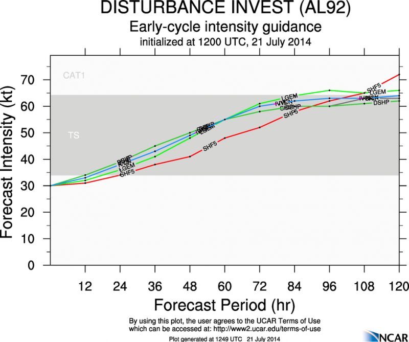
000
WHXX01 KWBC 211231
CHGHUR
TROPICAL CYCLONE GUIDANCE MESSAGE
NWS NATIONAL HURRICANE CENTER MIAMI FL
1231 UTC MON JUL 21 2014
DISCLAIMER...NUMERICAL MODELS ARE SUBJECT TO LARGE ERRORS.
PLEASE REFER TO NHC OFFICIAL FORECASTS FOR TROPICAL CYCLONE
AND SUBTROPICAL CYCLONE INFORMATION.
ATLANTIC OBJECTIVE AIDS FOR
DISTURBANCE INVEST (AL922014) 20140721 1200 UTC
...00 HRS... ...12 HRS... ...24 HRS... ...36 HRS...
140721 1200 140722 0000 140722 1200 140723 0000
LAT LON LAT LON LAT LON LAT LON
BAMS 11.4N 41.6W 12.0N 44.5W 12.4N 47.5W 12.8N 50.8W
BAMD 11.4N 41.6W 11.7N 44.6W 12.0N 47.6W 12.2N 50.5W
BAMM 11.4N 41.6W 12.2N 44.2W 12.8N 46.9W 13.4N 49.8W
LBAR 11.4N 41.6W 12.0N 45.0W 12.7N 48.7W 13.4N 52.5W
SHIP 30KTS 28KTS 33KTS 40KTS
DSHP 30KTS 28KTS 33KTS 40KTS
...48 HRS... ...72 HRS... ...96 HRS... ..120 HRS...
140723 1200 140724 1200 140725 1200 140726 1200
LAT LON LAT LON LAT LON LAT LON
BAMS 13.1N 54.3W 14.7N 62.2W 17.4N 70.2W 19.6N 76.8W
BAMD 12.3N 53.4W 12.9N 59.2W 14.5N 64.8W 16.7N 70.5W
BAMM 13.8N 53.0W 15.4N 59.4W 17.9N 65.1W 20.4N 69.7W
LBAR 14.1N 56.2W 15.7N 62.3W 17.6N 66.8W 0.0N 0.0W
SHIP 46KTS 55KTS 59KTS 63KTS
DSHP 46KTS 55KTS 59KTS 62KTS
...INITIAL CONDITIONS...
LATCUR = 11.4N LONCUR = 41.6W DIRCUR = 275DEG SPDCUR = 18KT
LATM12 = 11.2N LONM12 = 38.0W DIRM12 = 278DEG SPDM12 = 18KT
LATM24 = 10.3N LONM24 = 34.6W
WNDCUR = 30KT RMAXWD = 40NM WNDM12 = 30KT
CENPRS = 1013MB OUTPRS = 1015MB OUTRAD = 150NM SDEPTH = S
RD34NE = 0NM RD34SE = 0NM RD34SW = 0NM RD34NW = 0NM
ATL: TWO - Models
Moderator: S2k Moderators
-
cycloneye

- Admin

- Posts: 139083
- Age: 67
- Joined: Thu Oct 10, 2002 10:54 am
- Location: San Juan, Puerto Rico
ATL: TWO - Models
0 likes
Visit the Caribbean-Central America Weather Thread where you can find at first post web cams,radars
and observations from Caribbean basin members Click Here
and observations from Caribbean basin members Click Here
-
cycloneye
- Admin
- Posts: 139083
- Age: 67
- Joined: Thu Oct 10, 2002 10:54 am
- Location: San Juan, Puerto Rico
Re: ATL: INVEST 92L - Models

0 likes
Visit the Caribbean-Central America Weather Thread where you can find at first post web cams,radars
and observations from Caribbean basin members Click Here
and observations from Caribbean basin members Click Here

-
Blown Away

- S2K Supporter

- Posts: 9862
- Joined: Wed May 26, 2004 6:17 am
Re: ATL: INVEST 92L - Models


12z
0 likes
Hurricane Eye Experience: David 79, Irene 99, Frances 04, Jeanne 04, Wilma 05...
Hurricane Brush Experience: Andrew 92, Erin 95, Floyd 99, Matthew 16, Irma 17, Ian 22, Nicole 22…
Hurricane Brush Experience: Andrew 92, Erin 95, Floyd 99, Matthew 16, Irma 17, Ian 22, Nicole 22…
-
TheStormExpert

- Category 5

- Posts: 8487
- Age: 30
- Joined: Wed Feb 16, 2011 5:38 pm
- Location: Palm Beach Gardens, FL
Re:
Just a repeat of last year, where they showed Chantal and Dorian for example becoming more than what they amounted too. It may look impressively good now but if it develops further it wouldn't be long before those strong Easterlies cause the mlc to outrun llc.
0 likes
The following post is NOT an official forecast and should not be used as such. It is just the opinion of the poster and may or may not be backed by sound meteorological data. It is NOT endorsed by storm2k.org.
-
gatorcane

- S2K Supporter
- Posts: 23499
- Age: 46
- Joined: Sun Mar 13, 2005 3:54 pm
- Location: Boca Raton, FL
It's quite clear models are struggling with this system. The normally reliable GFS model runs from a couple of days ago had this heading WNW already at a position well north of where it is now and ending up well north of the Northern Leewards in the long-range.
The normally reliable ECMWF model had the track correct from the get-go with a more West track towards the Leewards but already had this system dissipating today. Looks like that is not going to happen.
It could be due to not having a lot of good observations out in the middle of the Atlantic or that the system is small.
0 likes

Re: ATL: INVEST 92L - Models
Excerpt from Dr. Masters:
http://www.wunderground.com/blog/JeffMasters/comment.html?entrynum=2732#commenttop
Global models still have not resolved this system, but after manual initialization by NHC, Early Track and Intensity model forecasts call for the system to become a Depression today and possibly reach Tropical Storm intensity during the next 48-72 hours once the system moves over waters that are warm enough to support storm formation.
ASSUMING this developing cyclone manages to become a Tropical storm or Hurricane near the eastern CARIB, extended global model forecasts depict a weakening of the sub-tropical ridge north of the system by then, and an approaching large-scale long wave TROF in the eastern US suggests the system will eventually turn northward away from the US mainland. However, this assumes that the system does in fact reach the northern CARIB as currently forecast by the early model runs. That said, should the cyclone stay on a more westerly track into the central CARIB AND manage to find a low shear environment this weekend - track / intensity forecasts beyond then become quite problematic. And, of course, the developing system could simply turn northward prior to reaching the CARIB and would simply head out sea by the weekend.
http://www.wunderground.com/blog/JeffMasters/comment.html?entrynum=2732#commenttop
0 likes
The following post is NOT an official forecast and should not be used as such. It is just the opinion of the poster and may or may not be backed by sound meteorological data. It is NOT endorsed by any professional institution including storm2k.org For Official Information please refer to the NHC and NWS products.
-
cycloneye
- Admin
- Posts: 139083
- Age: 67
- Joined: Thu Oct 10, 2002 10:54 am
- Location: San Juan, Puerto Rico
Re: ATL: INVEST 92L - Models
GFS Ensembles:

0 likes
Visit the Caribbean-Central America Weather Thread where you can find at first post web cams,radars
and observations from Caribbean basin members Click Here
and observations from Caribbean basin members Click Here
-
cycloneye
- Admin
- Posts: 139083
- Age: 67
- Joined: Thu Oct 10, 2002 10:54 am
- Location: San Juan, Puerto Rico
Re: ATL: INVEST 92L - Models
18z Tropical Models.
000
WHXX01 KWBC 211823
CHGHUR
TROPICAL CYCLONE GUIDANCE MESSAGE
NWS NATIONAL HURRICANE CENTER MIAMI FL
1823 UTC MON JUL 21 2014
DISCLAIMER...NUMERICAL MODELS ARE SUBJECT TO LARGE ERRORS.
PLEASE REFER TO NHC OFFICIAL FORECASTS FOR TROPICAL CYCLONE
AND SUBTROPICAL CYCLONE INFORMATION.
ATLANTIC OBJECTIVE AIDS FOR
DISTURBANCE INVEST (AL922014) 20140721 1800 UTC
...00 HRS... ...12 HRS... ...24 HRS... ...36 HRS...
140721 1800 140722 0600 140722 1800 140723 0600
LAT LON LAT LON LAT LON LAT LON
BAMS 11.5N 43.1W 12.0N 46.0W 12.4N 49.0W 12.7N 52.1W
BAMD 11.5N 43.1W 11.8N 46.1W 12.1N 49.0W 12.3N 51.7W
BAMM 11.5N 43.1W 12.2N 45.7W 12.9N 48.4W 13.4N 51.3W
LBAR 11.5N 43.1W 11.9N 46.4W 12.6N 50.2W 13.3N 54.0W
SHIP 30KTS 36KTS 43KTS 49KTS
DSHP 30KTS 36KTS 43KTS 49KTS
...48 HRS... ...72 HRS... ...96 HRS... ..120 HRS...
140723 1800 140724 1800 140725 1800 140726 1800
LAT LON LAT LON LAT LON LAT LON
BAMS 13.1N 55.5W 14.8N 63.2W 17.7N 71.0W 20.0N 77.4W
BAMD 12.5N 54.4W 13.1N 59.9W 14.6N 65.3W 16.7N 71.0W
BAMM 13.9N 54.3W 15.6N 60.4W 18.2N 65.7W 20.8N 70.0W
LBAR 14.1N 57.6W 15.8N 63.7W 17.6N 67.9W 0.0N 0.0W
SHIP 54KTS 62KTS 64KTS 67KTS
DSHP 54KTS 62KTS 64KTS 65KTS
...INITIAL CONDITIONS...
LATCUR = 11.5N LONCUR = 43.1W DIRCUR = 275DEG SPDCUR = 17KT
LATM12 = 11.4N LONM12 = 39.8W DIRM12 = 274DEG SPDM12 = 18KT
LATM24 = 10.9N LONM24 = 36.2W
WNDCUR = 30KT RMAXWD = 40NM WNDM12 = 25KT
CENPRS = 1013MB OUTPRS = 1015MB OUTRAD = 150NM SDEPTH = S
RD34NE = 0NM RD34SE = 0NM RD34SW = 0NM RD34NW = 0NM
0 likes
Visit the Caribbean-Central America Weather Thread where you can find at first post web cams,radars
and observations from Caribbean basin members Click Here
and observations from Caribbean basin members Click Here
-
cycloneye
- Admin
- Posts: 139083
- Age: 67
- Joined: Thu Oct 10, 2002 10:54 am
- Location: San Juan, Puerto Rico
Re: ATL: INVEST 92L - Models
Notice that HWRF doesn't develop.

0 likes
Visit the Caribbean-Central America Weather Thread where you can find at first post web cams,radars
and observations from Caribbean basin members Click Here
and observations from Caribbean basin members Click Here
-
Blown Away
- S2K Supporter
- Posts: 9862
- Joined: Wed May 26, 2004 6:17 am
Re: ATL: INVEST 92L - Models

18z
0 likes
Hurricane Eye Experience: David 79, Irene 99, Frances 04, Jeanne 04, Wilma 05...
Hurricane Brush Experience: Andrew 92, Erin 95, Floyd 99, Matthew 16, Irma 17, Ian 22, Nicole 22…
Hurricane Brush Experience: Andrew 92, Erin 95, Floyd 99, Matthew 16, Irma 17, Ian 22, Nicole 22…
-
gatorcane
- S2K Supporter
- Posts: 23499
- Age: 46
- Joined: Sun Mar 13, 2005 3:54 pm
- Location: Boca Raton, FL
Re:
From the 5pmEST TWD which answers the question why the global models are struggling with this system so far:
"Note that the global models are having a difficult time tracking the small
vortex, and confidence in the details of the track forecast is lower
than usual."
"Note that the global models are having a difficult time tracking the small
vortex, and confidence in the details of the track forecast is lower
than usual."
0 likes
Re: ATL: TWO - Models
So did the ECMWF crashed or something? I can't find its 12z run anywhere.
0 likes
-
TexasBreeze
- Tropical Depression

- Posts: 79
- Joined: Mon Jul 07, 2014 12:50 pm
Re: ATL: TWO - Models
AREA FORECAST DISCUSSION
NATIONAL WEATHER SERVICE CORPUS CHRISTI TX
329 PM CDT MON JUL 21 2014 .
SHORT TERM (TONIGHT THROUGH TUESDAY NIGHT)...ISOLATED CONVECTION HAS DEVELOP WEST OF THE FORECAST AREA OVER MEXICO AND NORTHEAST OF THE AREA AS WELL. WILL KEEP THE ISOLATED 10 POPS WITH MENTION OF THUNDERSTORMS IN THE FORECAST THROUGH 00Z AS DAYTIME HEATING MAY BE SUFFICIENT ENOUGH TO GENERATE ISOLATED SHOWERS/STORMS. AS WITH YESTERDAY...A FEW LOCATIONS ARE REPORTING HI VALUES BETWEEN 110 AND 112 DEGREES THIS AFTERNOON. SPS CURRENTLY ADDRESSES THE HEAT BUT WILL CONTINUE TO MONITOR TO SEE IF 110 HEAT INDEX VALUES BECOME MORE WIDESPREAD. UPPER LEVEL RIDGE WILL BE THE MAIN WEATHER FEATURE IMPACTING THE WEATHER OVER SOUTH TEXAS...WHICH WILL RESULT IN MOSTLY DRY AND VERY WARM TO HOT CONDITIONS. HIGH TEMPERATURES ON TUESDAY WILL AGAIN RANGE FROM ABOUT 105 AT LAREDO...WITH MID/UPPER 90S ELSEWHERE EXCEPT FOR THE COAST WHERE HIGHS WILL BE AROUND 90. HEAT INDEX VALUES WILL AGAIN BE BETWEEN 105 AND 109 DEGREES ON TUESDAY ACROSS PARTS OF THE AREA. && .
LONG TERM (WEDNESDAY THROUGH MONDAY)...WEAKENING MID LEVEL LOW ACROSS N CENTRAL GULF COAST AT START OF PERIOD WILL DRIFT WEST DURING MID/LATE WEEK AND TRANSITION TO MORE OF A SHEAR AXIS BECOMING DRAPED JUST EAST OF THE TEXAS COAST. PROXIMITY OF SHEAR AXIS SHOULD LEAD TO AT LEAST ISOLATED SHOWERS AND THUNDERSTORMS ACROSS THE EASTERN HALF OF THE CWA WEDNESDAY AND THURSDAY AFTERNOONS. MAIN LIMITING FACTOR TO FOR GREATER PRECIP CHANCES WILL BE UNFAVORABLE AXIS PLACEMENT...AS WELL AS MOISTURE AND THERMAL PROFILES. HAVE GONE WITH A BLEND OF THE 12Z GFS AND CMC FOR THIS FORECAST PACKAGE /12Z ECMWF CURRENTLY UNAVAILABLE DUE TO EURO SITE ISSUES/. SHEAR AXIS SHIFTS/DISSIPATES WESTWARD LATE IN THE WEEK WITH A DRIER MOISTURE PROFILE PROG TO SLIDE INTO THE REGION FROM THE GULF. AT THE SAME TIME H5 RIDGING IS EXPECTED TO STRENGTHEN WHICH OVERALL WILL LEAD TO SLIGHTLY HOTTER DAYTIME TEMPS FOR THE SECOND HALF OF THE LONG TERM PERIOD.
0 likes

-
cycloneye
- Admin
- Posts: 139083
- Age: 67
- Joined: Thu Oct 10, 2002 10:54 am
- Location: San Juan, Puerto Rico
Re: ATL: TWO - Models
As we know from the 5 PM discussion,NHC didn't put credence to the SHIP intensity forecast but I am posting the 00z run anyway as information to the members.
000
WHXX01 KWBC 220032
CHGHUR
TROPICAL CYCLONE GUIDANCE MESSAGE
NWS NATIONAL HURRICANE CENTER MIAMI FL
0032 UTC TUE JUL 22 2014
DISCLAIMER...NUMERICAL MODELS ARE SUBJECT TO LARGE ERRORS.
PLEASE REFER TO NHC OFFICIAL FORECASTS FOR TROPICAL CYCLONE
AND SUBTROPICAL CYCLONE INFORMATION.
ATLANTIC OBJECTIVE AIDS FOR
TROPICAL CYCLONE TWO (AL022014) 20140722 0000 UTC
...00 HRS... ...12 HRS... ...24 HRS... ...36 HRS...
140722 0000 140722 1200 140723 0000 140723 1200
LAT LON LAT LON LAT LON LAT LON
BAMS 12.0N 44.4W 12.7N 47.0W 13.5N 49.6W 14.1N 52.4W
BAMD 12.0N 44.4W 12.5N 46.8W 13.1N 49.2W 13.6N 51.5W
BAMM 12.0N 44.4W 12.8N 47.1W 13.5N 50.0W 14.2N 53.2W
LBAR 12.0N 44.4W 12.7N 47.5W 13.5N 51.0W 14.2N 54.5W
SHIP 30KTS 34KTS 39KTS 44KTS
DSHP 30KTS 34KTS 39KTS 44KTS
...48 HRS... ...72 HRS... ...96 HRS... ..120 HRS...
140724 0000 140725 0000 140726 0000 140727 0000
LAT LON LAT LON LAT LON LAT LON
BAMS 14.9N 55.3W 17.2N 61.7W 20.4N 67.4W 23.6N 70.9W
BAMD 14.1N 53.6W 15.4N 57.8W 17.1N 61.8W 18.8N 65.5W
BAMM 15.1N 56.2W 17.3N 61.7W 19.9N 66.2W 22.2N 69.4W
LBAR 15.0N 57.9W 16.8N 63.8W 19.8N 68.6W 0.0N 0.0W
SHIP 48KTS 53KTS 57KTS 65KTS
DSHP 48KTS 53KTS 57KTS 42KTS
...INITIAL CONDITIONS...
LATCUR = 12.0N LONCUR = 44.4W DIRCUR = 285DEG SPDCUR = 14KT
LATM12 = 11.4N LONM12 = 41.6W DIRM12 = 274DEG SPDM12 = 16KT
LATM24 = 11.2N LONM24 = 38.0W
WNDCUR = 30KT RMAXWD = 40NM WNDM12 = 30KT
CENPRS = 1012MB OUTPRS = 1015MB OUTRAD = 150NM SDEPTH = M
RD34NE = 0NM RD34SE = 0NM RD34SW = 0NM RD34NW = 0NM
$$
NNNN
0 likes
Visit the Caribbean-Central America Weather Thread where you can find at first post web cams,radars
and observations from Caribbean basin members Click Here
and observations from Caribbean basin members Click Here
Who is online
Users browsing this forum: No registered users and 101 guests