

ATL: BERTHA - Models
Moderator: S2k Moderators
Re: ATL: INVEST 93L - Models
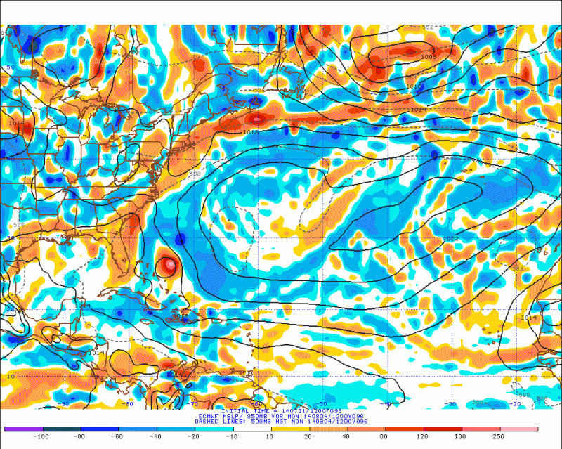
I find it quite the contradiction how now the Euro is bullish versus the GFS which is not. Typically it is the other way around. I expect the Euro though to back down on today's run, below is the forecast for last night 48hrs. Right now it is among the most bullish along with the CMC.
0 likes
The following post is NOT an official forecast and should not be used as such. It is just the opinion of the poster and may or may not be backed by sound meteorological data. It is NOT endorsed by any professional institution including storm2k.org For Official Information please refer to the NHC and NWS products.
-
Dean4Storms
- S2K Supporter

- Posts: 6355
- Age: 61
- Joined: Sun Aug 31, 2003 1:01 pm
- Location: Miramar Bch. FL

-
TheStormExpert

- Category 5

- Posts: 8487
- Age: 30
- Joined: Wed Feb 16, 2011 5:38 pm
- Location: Palm Beach Gardens, FL
Re:
NDG wrote:12z Euro has it slightly strengthening just east of the Bahamas by Monday with an anticylonic flow building on top of it, which makes sense since this area is part of the Atlantic which has had the best UL conditions all season long so far.
What is the overall run like?
0 likes
The following post is NOT an official forecast and should not be used as such. It is just the opinion of the poster and may or may not be backed by sound meteorological data. It is NOT endorsed by storm2k.org.
Re: Re:
TheStormExpert wrote:NDG wrote:12z Euro has it slightly strengthening just east of the Bahamas by Monday with an anticylonic flow building on top of it, which makes sense since this area is part of the Atlantic which has had the best UL conditions all season long so far.
What is the overall run like?
Not much strengthening over the next 72 hrs until it gets near the Bahamas but weakness along the eastern US will make it recurve out to sea, according to this run.
Last edited by NDG on Thu Jul 31, 2014 2:48 pm, edited 1 time in total.
0 likes
Re: Re:
NDG wrote:TheStormExpert wrote:NDG wrote:12z Euro has it slightly strengthening just east of the Bahamas by Monday with an anticylonic flow building on top of it, which makes sense since this area is part of the Atlantic which has had the best UL conditions all season long so far.
What is the overall run like?
Not much strengthening over the next 72 hrs until it gets near the Bahamas but weakness along the eastern US will make it recurve out to sea, according to this run.
http://mp1.met.psu.edu/~fxg1/ECMWFTROPA ... 2z/f96.gif[/img]
Thanks for the post. I actually looked at the run and I don't see any weakening during the entire run it is actually the strongest run to date on this system. The system looks terrible right now nowhere near what the Euro is showing. Unless majic pixie dust where to be sprinkled on 93l very soon I can't see this run verifying. Normally the Euro is the conservative one and the GFS the over aggressive. What the heck is going on here...

Last edited by blp on Thu Jul 31, 2014 2:30 pm, edited 2 times in total.
0 likes
The following post is NOT an official forecast and should not be used as such. It is just the opinion of the poster and may or may not be backed by sound meteorological data. It is NOT endorsed by any professional institution including storm2k.org For Official Information please refer to the NHC and NWS products.


-
somethingfunny

- ChatStaff

- Posts: 3926
- Age: 35
- Joined: Thu May 31, 2007 10:30 pm
- Location: McKinney, Texas
So this is no longer a question of "if it stays weak, it stays south and misses the trough" at all, is it?
0 likes
I am not a meteorologist, and any posts made by me are not official forecasts or to be interpreted as being intelligent. These posts are just my opinions and are probably silly opinions.
Re: Re:
blp wrote:NDG wrote:TheStormExpert wrote:What is the overall run like?
Not much strengthening over the next 72 hrs until it gets near the Bahamas but weakness along the eastern US will make it recurve out to sea, according to this run.
http://mp1.met.psu.edu/~fxg1/ECMWFTROPA ... 2z/f96.gif[/img]
Thanks for the post. I actually looked at the run and I don't see any weakening during the entire run it is actually the strongest run to date on this system. The system looks terrible right now nowhere near what the Euro is showing. Unless majic pixie dust where to be sprinkled on 93l very soon I can't see this run verifying. Normally the Euro is the conservative one and the GFS the over aggressive. What the heck is going on here...
But remember that the hr euro forecast maps on the PSU site show the vorticity only, which is actually fairly strong, no question about it. The current surface pressure is actually lower than what the euro shows.

0 likes
-
SFLcane

- S2K Supporter
- Posts: 9606
- Age: 46
- Joined: Sat Jun 05, 2010 1:44 pm
- Location: Lake Worth Florida
Re: ATL: INVEST 93L - Models
yep westward trend there...worth keeping eye on swirl near sw atlantic.

0 likes
-
gatorcane

- S2K Supporter
- Posts: 23499
- Age: 46
- Joined: Sun Mar 13, 2005 3:54 pm
- Location: Boca Raton, FL
somethingfunny wrote:So this is no longer a question of "if it stays weak, it stays south and misses the trough" at all, is it?
Generally yes, still looks like a case of weak=west and strong=east once it clears the islands, however, I have noticed the global models are trending towards trying to build in a bit of a stronger and wider ridge over the SW Atlantic in the wake of the big east coast trough (that is gradually lifting out now)
But the current timing shows this system rounding the ridge on a recurve over or near the Bahamas before that ridge can really expand. Will need to watch the evolution of this trough/ridge setup and see if models continue to trend towards more ridging and/or change the timing of 93L as far as when it clears the islands.
The posts in this forum are NOT official forecast and should not be used as such. They are just the opinion of the poster and may or may not be backed by sound meteorological data. They are NOT endorsed by any professional institution or storm2k.org. For official information, please refer to the NHC and NWS products.
0 likes
-
Blown Away

- S2K Supporter
- Posts: 9861
- Joined: Wed May 26, 2004 6:17 am
Re: ATL: INVEST 93L - Models
NHC likes to hug the TVCN consensus model and the 18z ends in the NW Bahamas... It's a good thing the dry air is out there because the model path is a classic path for hurricanes...
0 likes
Hurricane Eye Experience: David 79, Irene 99, Frances 04, Jeanne 04, Wilma 05...
Hurricane Brush Experience: Andrew 92, Erin 95, Floyd 99, Matthew 16, Irma 17, Ian 22, Nicole 22…
Hurricane Brush Experience: Andrew 92, Erin 95, Floyd 99, Matthew 16, Irma 17, Ian 22, Nicole 22…

The big question I have is how much is the Euro actually taking the dry air into account.
0 likes
The above post is not official and should not be used as such. It is the opinion of the poster and may or may not be backed by sound meteorological data. It is not endorsed by any professional institution or storm2k.org. For official information, please refer to the NHC and NWS products.
Re:
Hammy wrote:The big question I have is how much is the Euro actually taking the dry air into account.
It did a lot better than the GFS when it was in the middle of the Atlantic regarding the dry air. There is currently no problems with dry air north of the Antilles.
0 likes
-
cycloneye

- Admin

- Posts: 139082
- Age: 67
- Joined: Thu Oct 10, 2002 10:54 am
- Location: San Juan, Puerto Rico
Re: ATL: INVEST 93L - Models
WHXX01 KWBC 010014
CHGHUR
TROPICAL CYCLONE GUIDANCE MESSAGE
NWS NATIONAL HURRICANE CENTER MIAMI FL
0014 UTC FRI AUG 1 2014
DISCLAIMER...NUMERICAL MODELS ARE SUBJECT TO LARGE ERRORS.
PLEASE REFER TO NHC OFFICIAL FORECASTS FOR TROPICAL CYCLONE
AND SUBTROPICAL CYCLONE INFORMATION.
ATLANTIC OBJECTIVE AIDS FOR
DISTURBANCE INVEST (AL932014) 20140801 0000 UTC
...00 HRS... ...12 HRS... ...24 HRS... ...36 HRS...
140801 0000 140801 1200 140802 0000 140802 1200
LAT LON LAT LON LAT LON LAT LON
BAMS 12.0N 54.7W 13.2N 58.0W 14.9N 61.4W 16.7N 65.0W
BAMD 12.0N 54.7W 12.6N 57.0W 13.8N 59.3W 15.5N 61.7W
BAMM 12.0N 54.7W 12.9N 57.4W 14.2N 60.1W 15.8N 62.9W
LBAR 12.0N 54.7W 12.8N 57.5W 14.0N 60.8W 15.5N 64.1W
...48 HRS... ...72 HRS... ...96 HRS... ..120 HRS...
140803 0000 140804 0000 140805 0000 140806 0000
LAT LON LAT LON LAT LON LAT LON
BAMS 18.6N 68.3W 22.0N 74.2W 25.2N 77.1W 27.8N 76.7W
BAMD 17.4N 64.4W 21.5N 69.6W 25.3N 72.9W 28.7N 72.8W
BAMM 17.7N 65.8W 21.6N 71.1W 25.2N 74.3W 28.3N 74.0W
LBAR 17.5N 67.2W 22.5N 72.2W 27.6N 73.4W 31.5N 68.7W
...INITIAL CONDITIONS...
LATCUR = 12.0N LONCUR = 54.7W DIRCUR = 285DEG SPDCUR = 16KT
LATM12 = 11.0N LONM12 = 51.4W DIRM12 = 284DEG SPDM12 = 17KT
LATM24 = 10.4N LONM24 = 47.9W
WNDCUR = 40KT RMAXWD = 30NM WNDM12 = 40KT
CENPRS = 1008MB OUTPRS = 1012MB OUTRAD = 120NM SDEPTH = M
RD34NE = 40NM RD34SE = 40NM RD34SW = 0NM RD34NW = 40NM
$$
NNNN
0 likes
Visit the Caribbean-Central America Weather Thread where you can find at first post web cams,radars
and observations from Caribbean basin members Click Here
and observations from Caribbean basin members Click Here

-
TheStormExpert
- Category 5
- Posts: 8487
- Age: 30
- Joined: Wed Feb 16, 2011 5:38 pm
- Location: Palm Beach Gardens, FL
Re:
gatorcane wrote:Looks how much the BAMS are hooking here...by the way the BAMs have completely changed from a west bend from earlier today to an east hook:
http://i58.tinypic.com/2me642.jpg
Starts to make you wonder if strong riffing builds into the north. Hmmm...
0 likes
The following post is NOT an official forecast and should not be used as such. It is just the opinion of the poster and may or may not be backed by sound meteorological data. It is NOT endorsed by storm2k.org.
-
Blown Away
- S2K Supporter
- Posts: 9861
- Joined: Wed May 26, 2004 6:17 am
Re: ATL: INVEST 93L - Models
0 likes
Hurricane Eye Experience: David 79, Irene 99, Frances 04, Jeanne 04, Wilma 05...
Hurricane Brush Experience: Andrew 92, Erin 95, Floyd 99, Matthew 16, Irma 17, Ian 22, Nicole 22…
Hurricane Brush Experience: Andrew 92, Erin 95, Floyd 99, Matthew 16, Irma 17, Ian 22, Nicole 22…


Who is online
Users browsing this forum: No registered users and 115 guests