ATL: CRISTOBAL - Models
Moderator: S2k Moderators
-
cycloneye

- Admin

- Posts: 139084
- Age: 67
- Joined: Thu Oct 10, 2002 10:54 am
- Location: San Juan, Puerto Rico
ATL: CRISTOBAL - Models
Models here.
0 likes
Visit the Caribbean-Central America Weather Thread where you can find at first post web cams,radars
and observations from Caribbean basin members Click Here
and observations from Caribbean basin members Click Here
-
cycloneye
- Admin
- Posts: 139084
- Age: 67
- Joined: Thu Oct 10, 2002 10:54 am
- Location: San Juan, Puerto Rico
Re: ATL: INVEST 96L - Models
CHGHUR
TROPICAL CYCLONE GUIDANCE MESSAGE
NWS NATIONAL HURRICANE CENTER MIAMI FL
1801 UTC TUE AUG 19 2014
DISCLAIMER...NUMERICAL MODELS ARE SUBJECT TO LARGE ERRORS.
PLEASE REFER TO NHC OFFICIAL FORECASTS FOR TROPICAL CYCLONE
AND SUBTROPICAL CYCLONE INFORMATION.
ATLANTIC OBJECTIVE AIDS FOR
DISTURBANCE INVEST (AL962014) 20140819 1800 UTC
...00 HRS... ...12 HRS... ...24 HRS... ...36 HRS...
140819 1800 140820 0600 140820 1800 140821 0600
LAT LON LAT LON LAT LON LAT LON
BAMS 10.0N 49.0W 10.9N 50.2W 11.9N 51.9W 12.9N 54.1W
BAMD 10.0N 49.0W 10.1N 51.2W 10.4N 53.6W 10.9N 56.1W
BAMM 10.0N 49.0W 10.3N 51.0W 10.9N 53.2W 11.6N 55.6W
LBAR 10.0N 49.0W 9.9N 51.5W 10.2N 54.5W 10.7N 57.6W
SHIP 20KTS 26KTS 36KTS 49KTS
DSHP 20KTS 26KTS 36KTS 49KTS
...48 HRS... ...72 HRS... ...96 HRS... ..120 HRS...
140821 1800 140822 1800 140823 1800 140824 1800
LAT LON LAT LON LAT LON LAT LON
BAMS 14.1N 57.1W 16.4N 64.3W 18.3N 71.9W 19.1N 78.0W
BAMD 11.5N 58.7W 13.4N 63.5W 15.7N 67.5W 17.9N 71.1W
BAMM 12.6N 58.2W 15.0N 63.5W 17.4N 68.9W 19.9N 74.2W
LBAR 11.3N 61.0W 12.6N 67.2W 16.3N 71.9W 17.6N 75.8W
SHIP 62KTS 83KTS 89KTS 91KTS
DSHP 62KTS 83KTS 89KTS 65KTS
...INITIAL CONDITIONS...
LATCUR = 10.0N LONCUR = 49.0W DIRCUR = 250DEG SPDCUR = 12KT
LATM12 = 10.8N LONM12 = 46.7W DIRM12 = 251DEG SPDM12 = 14KT
LATM24 = 11.9N LONM24 = 43.8W
WNDCUR = 20KT RMAXWD = 0NM WNDM12 = 20KT
CENPRS = 1009MB OUTPRS = 1010MB OUTRAD = 150NM SDEPTH = M
RD34NE = 0NM RD34SE = 0NM RD34SW = 0NM RD34NW = 0NM
0 likes
Visit the Caribbean-Central America Weather Thread where you can find at first post web cams,radars
and observations from Caribbean basin members Click Here
and observations from Caribbean basin members Click Here
-
cycloneye
- Admin
- Posts: 139084
- Age: 67
- Joined: Thu Oct 10, 2002 10:54 am
- Location: San Juan, Puerto Rico
Re: ATL: INVEST 96L - Models
12z UKMET:
NEW TROPICAL STORM FORECAST TO DEVELOP AFTER 30 HOURS
FORECAST POSITION AT T+ 30 : 12.0N 53.1W
VERIFYING TIME POSITION STRENGTH TENDENCY
-------------- -------- -------- --------
00UTC 21.08.2014 12.1N 53.8W WEAK WEAKENING SLIGHTLY
12UTC 21.08.2014 14.6N 55.2W WEAK LITTLE CHANGE
00UTC 22.08.2014 16.5N 59.7W WEAK LITTLE CHANGE
12UTC 22.08.2014 15.7N 63.8W WEAK LITTLE CHANGE
00UTC 23.08.2014 16.8N 66.6W WEAK INTENSIFYING SLIGHTLY
12UTC 23.08.2014 17.6N 69.4W MODERATE INTENSIFYING SLIGHTLY
00UTC 24.08.2014 18.2N 71.8W INTENSE INTENSIFYING RAPIDLY
12UTC 24.08.2014 19.5N 75.1W WEAK WEAKENING RAPIDLY
00UTC 25.08.2014 19.6N 76.8W WEAK LITTLE CHANGE
12UTC 25.08.2014 20.9N 79.6W WEAK LITTLE CHANGE
0 likes
Visit the Caribbean-Central America Weather Thread where you can find at first post web cams,radars
and observations from Caribbean basin members Click Here
and observations from Caribbean basin members Click Here
-
northjaxpro

- S2K Supporter

- Posts: 8900
- Joined: Mon Sep 27, 2010 11:21 am
- Location: Jacksonville, FL
Wow, should this verify, UKMET going for rapid intensification approaching landfall near Hispaniola, then getting torn by it as you would expect after tangling with Hispaniola .
0 likes
NEVER, EVER SAY NEVER in the tropics and weather in general, and most importantly, with life itself!!
________________________________________________________________________________________
Fay 2008 Beryl 2012 Debby 2012 Colin 2016 Hermine 2016 Julia 2016 Matthew 2016 Irma 2017 Dorian 2019
________________________________________________________________________________________
Fay 2008 Beryl 2012 Debby 2012 Colin 2016 Hermine 2016 Julia 2016 Matthew 2016 Irma 2017 Dorian 2019
-
stormlover2013
- Category 5

- Posts: 2312
- Joined: Thu Aug 22, 2013 12:06 pm
- Location: Lumberton, Texas
-
tolakram
- Admin
- Posts: 19165
- Age: 60
- Joined: Sun Aug 27, 2006 8:23 pm
- Location: Florence, KY (name is Mark)
Re: ATL: INVEST 96L - Models
stormlover2013 wrote:pic please
There are no pics at the moment for the latest model runs.
0 likes
M a r k
- - - - -
Join us in chat: Storm2K Chatroom Invite. Android and IOS apps also available.
The posts in this forum are NOT official forecasts and should not be used as such. Posts are NOT endorsed by any professional institution or STORM2K.org. For official information and forecasts, please refer to NHC and NWS products.
-
cycloneye
- Admin
- Posts: 139084
- Age: 67
- Joined: Thu Oct 10, 2002 10:54 am
- Location: San Juan, Puerto Rico
Re: ATL: INVEST 96L - Models
18z BAMS.


0 likes
Visit the Caribbean-Central America Weather Thread where you can find at first post web cams,radars
and observations from Caribbean basin members Click Here
and observations from Caribbean basin members Click Here
-
tolakram
- Admin
- Posts: 19165
- Age: 60
- Joined: Sun Aug 27, 2006 8:23 pm
- Location: Florence, KY (name is Mark)
Re: ATL: INVEST 96L - Models
Euro running.
It appears now to latch onto the first wave ... maybe.
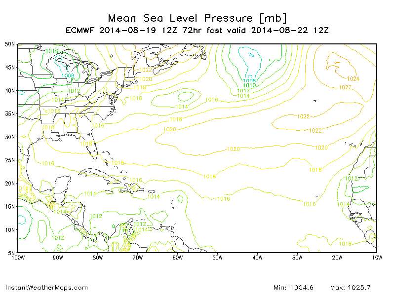
It appears now to latch onto the first wave ... maybe.
0 likes
M a r k
- - - - -
Join us in chat: Storm2K Chatroom Invite. Android and IOS apps also available.
The posts in this forum are NOT official forecasts and should not be used as such. Posts are NOT endorsed by any professional institution or STORM2K.org. For official information and forecasts, please refer to NHC and NWS products.
- - - - -
Join us in chat: Storm2K Chatroom Invite. Android and IOS apps also available.
The posts in this forum are NOT official forecasts and should not be used as such. Posts are NOT endorsed by any professional institution or STORM2K.org. For official information and forecasts, please refer to NHC and NWS products.

-
stormlover2013
- Category 5
- Posts: 2312
- Joined: Thu Aug 22, 2013 12:06 pm
- Location: Lumberton, Texas
-
tolakram
- Admin
- Posts: 19165
- Age: 60
- Joined: Sun Aug 27, 2006 8:23 pm
- Location: Florence, KY (name is Mark)
Re: ATL: INVEST 96L - Models
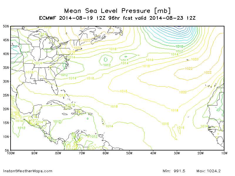
While weak the euro has now gone south.
0 likes
M a r k
- - - - -
Join us in chat: Storm2K Chatroom Invite. Android and IOS apps also available.
The posts in this forum are NOT official forecasts and should not be used as such. Posts are NOT endorsed by any professional institution or STORM2K.org. For official information and forecasts, please refer to NHC and NWS products.
- - - - -
Join us in chat: Storm2K Chatroom Invite. Android and IOS apps also available.
The posts in this forum are NOT official forecasts and should not be used as such. Posts are NOT endorsed by any professional institution or STORM2K.org. For official information and forecasts, please refer to NHC and NWS products.
-
tolakram
- Admin
- Posts: 19165
- Age: 60
- Joined: Sun Aug 27, 2006 8:23 pm
- Location: Florence, KY (name is Mark)
Re: ATL: INVEST 96L - Models
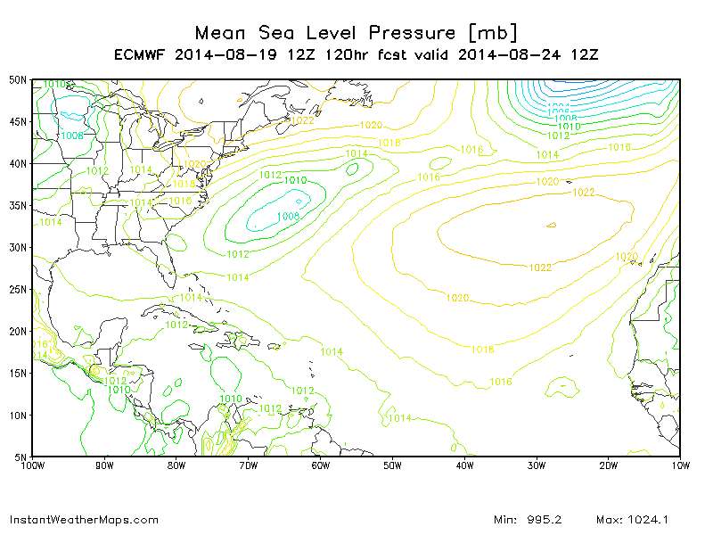
120h, broad low, or possibly a resolution issue on this one with this map.
0 likes
M a r k
- - - - -
Join us in chat: Storm2K Chatroom Invite. Android and IOS apps also available.
The posts in this forum are NOT official forecasts and should not be used as such. Posts are NOT endorsed by any professional institution or STORM2K.org. For official information and forecasts, please refer to NHC and NWS products.
- - - - -
Join us in chat: Storm2K Chatroom Invite. Android and IOS apps also available.
The posts in this forum are NOT official forecasts and should not be used as such. Posts are NOT endorsed by any professional institution or STORM2K.org. For official information and forecasts, please refer to NHC and NWS products.
-
stormlover2013
- Category 5
- Posts: 2312
- Joined: Thu Aug 22, 2013 12:06 pm
- Location: Lumberton, Texas
-
Kingarabian

- S2K Supporter
- Posts: 15435
- Joined: Sat Aug 08, 2009 3:06 am
- Location: Honolulu, Hawaii
Re: ATL: INVEST 96L - Models
stormlover2013 wrote:so where is the euro at 120 hours?
Caribbean.
0 likes
RIP Kobe Bryant
-
Yellow Evan

- Professional-Met

- Posts: 15952
- Age: 25
- Joined: Fri Jul 15, 2011 12:48 pm
- Location: Henderson, Nevada/Honolulu, HI
- Contact:
* ATLANTIC SHIPS INTENSITY FORECAST *
* GOES AVAILABLE, OHC AVAILABLE *
* INVEST AL962014 08/19/14 18 UTC *
TIME (HR) 0 6 12 18 24 36 48 60 72 84 96 108 120
V (KT) NO LAND 25 29 33 39 45 59 71 82 93 95 96 98 96
V (KT) LAND 25 29 33 39 45 59 71 82 93 95 96 98 70
V (KT) LGE mod 25 28 31 34 37 44 53 64 79 92 100 102 74
Storm Type TROP TROP TROP TROP TROP TROP TROP TROP TROP TROP TROP TROP TROP
SHEAR (KT) 10 11 11 16 19 16 23 5 7 8 11 18 14
SHEAR ADJ (KT) 8 7 6 4 1 -1 -4 -5 -2 -1 -1 -6 -5
SHEAR DIR 55 64 30 22 35 45 43 22 352 280 300 288 287
SST (C) 28.7 28.7 28.8 28.8 28.7 28.3 28.0 27.8 27.9 28.3 28.5 28.8 29.5
0 likes
-
Kingarabian
- S2K Supporter
- Posts: 15435
- Joined: Sat Aug 08, 2009 3:06 am
- Location: Honolulu, Hawaii
-
tolakram
- Admin
- Posts: 19165
- Age: 60
- Joined: Sun Aug 27, 2006 8:23 pm
- Location: Florence, KY (name is Mark)
Re: ATL: INVEST 96L - Models
Euro loses it at 144. The sharp west to somehow southwest turn between 72 and 96 is very suspicious.
0 likes
M a r k
- - - - -
Join us in chat: Storm2K Chatroom Invite. Android and IOS apps also available.
The posts in this forum are NOT official forecasts and should not be used as such. Posts are NOT endorsed by any professional institution or STORM2K.org. For official information and forecasts, please refer to NHC and NWS products.
- - - - -
Join us in chat: Storm2K Chatroom Invite. Android and IOS apps also available.
The posts in this forum are NOT official forecasts and should not be used as such. Posts are NOT endorsed by any professional institution or STORM2K.org. For official information and forecasts, please refer to NHC and NWS products.

Re: ATL: INVEST 96L - Models
tolakram wrote:While weak the euro has now gone south.
I had just posted this to the wrong thread not realizing the invest upgrade so am reposting here. Furthermore, now seeing the latest EURO, and in spite of the current BAM's and UK am even more apt to think this will pass south of Hispanola and E. Cuba.
Originally, I would have assumed that an adequate trough might cause a Caribbean tracker to bend north and threaten the Fla. West Coast or points north. Well, after taking a long look I for one am thinking that the GFS is going way overboard on its future development of essentially a large cutoff mid level low spinning off New England and causing a resultant weakening of the tropical ridge.
Per this mornings GFS 500mb, at 60 hour there are two stout 594 highs, one in the W. Gulf and one NE of Puerto Rico. A weakness along the US Eastern seaboard does exist, but these two anticyclones seems to be fairly well bridged. The large North Atlantic low appears to retreat with time and the Gulf High appears to move north and be expanding eastward. I do not see any resurgent energy moving east and dropping into what looks like a pretty benign 582 Hudson Bay low. In fact at or prior to 120 hours, there is NO Hudson Bay low and all that remains is a trapped 576 low off New England (at about 40N). All the while, the Gulf Upper High is pushed well into the Midwest, the Atlantic tropical ridge appears to be surging westward and the entire West Atlantic and NE U.S. is practically under one large anticyclonic midlevel flow. By 144 hour, the New England cut-off begins to be pulled up and out.
If the forecasted mid level ridging confirms (not unrealistic given that it is the middle of August), than it is my contention that the GFS is overplaying the closed cut-off low off New England. I do not think that it will break down such ridging (if it truly takes place), and this would lend for a system that is already in the Central Caribbean, to track further west where greater OHC exists and ultimately appear to steer such a system under a more dominant ridge toward perhaps the Texas or W. Louisiana coastline. Now, should a T.S. form a bit further north, than its development will likely be hindered by land (until perhaps reaching 80W?). Still seems that the result would remain more or less the same. Obviously I could be wrong and a deeper trough could degrade the ridging over the N. Caribbean, in which I suppose a system might "pop" north of Central or W. Cuba. Could be a scenario for a stall though, with the eventual retreating E. Coast trough, followed by a slow WNW or NW motion under a building ridge
0 likes
Personal Forecast Disclaimer:
The posts in this forum are NOT official forecast and should not be used as such. They are just the opinion of the poster and may or may not be backed by sound meteorological data. They are NOT endorsed by any professional institution or storm2k.org. For official information, please refer to the NHC and NWS products.
The posts in this forum are NOT official forecast and should not be used as such. They are just the opinion of the poster and may or may not be backed by sound meteorological data. They are NOT endorsed by any professional institution or storm2k.org. For official information, please refer to the NHC and NWS products.
-
gatorcane

- S2K Supporter
- Posts: 23499
- Age: 46
- Joined: Sun Mar 13, 2005 3:54 pm
- Location: Boca Raton, FL
chaser1 wrote:
Originally, I would have assumed that an adequate trough might cause a Caribbean tracker to bend north and threaten the Fla. West Coast or points north. Well, after taking a long look I for one am thinking that the GFS is going way overboard on its future development of essentially a large cutoff mid level low spinning off New England and causing a resultant weakening of the tropical ridge.
The Euro is also showing a large weakness over the Bahamas and Western Atlantic at 144 hours - you would think a somewhat deep system in the Caribbean would get pulled some to the NW towards that weakness. Euro keeps the low broad and doesn't develop it so it heads west with the low-level flow:

Last edited by gatorcane on Tue Aug 19, 2014 1:55 pm, edited 1 time in total.
0 likes
Who is online
Users browsing this forum: No registered users and 98 guests