
ATL: INVEST 98L - Discussion
Moderator: S2k Moderators
Re: ATL: INVEST 98L - Discussion
What are the chances that the eastern end of the trough strengthens? I heard Levi mentioning this possibility in his daily video update.
0 likes

Re:
southerngale wrote:It's supposed to bring us more rain. Good chances through Sunday. We don't need any more rain, but if it's going to rain anyway, hopefully we'll get some good thunderstorms out of it.
As a matter of fact, I'm hearing thunder now.
I thought Texas always needed rain? What do you grow for lawns just Bahia grass?
The Brownsville area outlook said possibly 2.25 inches of precipitation.
I would think Houston might get heavy rain with feeder bands bringing moisture in off the gulf.
0 likes
-
Tireman4

- S2K Supporter

- Posts: 5674
- Age: 58
- Joined: Fri Jun 30, 2006 1:08 pm
- Location: Humble, Texas
- Contact:
Re: Re:
Nimbus wrote:southerngale wrote:It's supposed to bring us more rain. Good chances through Sunday. We don't need any more rain, but if it's going to rain anyway, hopefully we'll get some good thunderstorms out of it.
As a matter of fact, I'm hearing thunder now.
I thought Texas always needed rain? What do you grow for lawns just Bahia grass?
The Brownsville area outlook said possibly 2.25 inches of precipitation.
I would think Houston might get heavy rain with feeder bands bringing moisture in off the gulf.
Nimbus,
We do. The South and West more than others. We are in much better shape than we were in 2011. We are dry in Houston, that is true. My lawn is starting to brown.
0 likes
-
Tireman4
- S2K Supporter
- Posts: 5674
- Age: 58
- Joined: Fri Jun 30, 2006 1:08 pm
- Location: Humble, Texas
- Contact:
Re: ATL: INVEST 98L - Discussion
[quote="somethingfunny"]At least the dry air isn't Texas's fault this time.
Another 2011 reference. Good one.
Another 2011 reference. Good one.
0 likes
-
cycloneye

- Admin

- Posts: 139086
- Age: 67
- Joined: Thu Oct 10, 2002 10:54 am
- Location: San Juan, Puerto Rico
Re: ATL: INVEST 98L - Discussion
Shower and thunderstorm activity associated with a weak area of low
pressure over the northwestern Gulf of Mexico is currently limited.
However, some development of this system is still possible before it
moves inland over south Texas and northern Mexico on Thursday.
* Formation chance through 48 hours...low...20 percent.
* Formation chance through 5 days...low...20 percent.
0 likes
Visit the Caribbean-Central America Weather Thread where you can find at first post web cams,radars
and observations from Caribbean basin members Click Here
and observations from Caribbean basin members Click Here
-
tropicwatch

- Category 5

- Posts: 3205
- Age: 60
- Joined: Sat Jun 02, 2007 10:01 am
- Location: Panama City Florida
- Contact:
Re: ATL: INVEST 98L - Discussion
Looks like it has stopped progressing westward. Temporarily at least.

0 likes
Tropicwatch
Agnes 72', Eloise 75, Elena 85', Kate 85', Charley 86', Florence 88', Beryl 94', Dean 95', Erin 95', Opal 95', Earl 98', Georges 98', Ivan 2004', Arlene 2005', Dennis 2005', Ida 2009' Debby 2012' Irma 2017' Michael 2018'
Agnes 72', Eloise 75, Elena 85', Kate 85', Charley 86', Florence 88', Beryl 94', Dean 95', Erin 95', Opal 95', Earl 98', Georges 98', Ivan 2004', Arlene 2005', Dennis 2005', Ida 2009' Debby 2012' Irma 2017' Michael 2018'

-
tropicwatch
- Category 5
- Posts: 3205
- Age: 60
- Joined: Sat Jun 02, 2007 10:01 am
- Location: Panama City Florida
- Contact:
Its moving again, looks like the COC might go in near the Texas/Mexican border.
Last edited by tropicwatch on Wed Aug 27, 2014 9:57 pm, edited 1 time in total.
0 likes
Tropicwatch
Agnes 72', Eloise 75, Elena 85', Kate 85', Charley 86', Florence 88', Beryl 94', Dean 95', Erin 95', Opal 95', Earl 98', Georges 98', Ivan 2004', Arlene 2005', Dennis 2005', Ida 2009' Debby 2012' Irma 2017' Michael 2018'
Agnes 72', Eloise 75, Elena 85', Kate 85', Charley 86', Florence 88', Beryl 94', Dean 95', Erin 95', Opal 95', Earl 98', Georges 98', Ivan 2004', Arlene 2005', Dennis 2005', Ida 2009' Debby 2012' Irma 2017' Michael 2018'

Re: ATL: INVEST 98L - Discussion
[quote="panamatropicwatch"]Looks like it has stopped progressing westward. Temporarily at least.[quote]
I agree. And I wouldn't be surprised if we wake tomorrow AM to see another burst like we did today....except with less shear, we may see even more convection near the "center"
I agree. And I wouldn't be surprised if we wake tomorrow AM to see another burst like we did today....except with less shear, we may see even more convection near the "center"
0 likes

Re: ATL: INVEST 98L - Discussion
So I just switched from Worlds Dumbest to Fox 8 and it was the end of a segment of Bob Breck running the Rpm model which I think is a tv service radar model thing like Vipir. Anyway it was stopped on Saturday PM with a tropical storm shaped radar looking thing over the Houston area. I have no other details but that would be surge 2 in this round. Unfortunately I didn't get the source region but he said it was coming up from the south (guessing not 98L but it's only 3 days???). It looked earlier like the models wound send westward whatever was in the boc. So this would be before that since it's Saturday. Probably another low coming from the base of that trough as it swings west across the Gulf. FWIW it didn't look like an extreme system but it was looking tropical storm-y on the sim radar. Who knows?
Edit to say there is a shot it was next Saturday but I don't think those types of models are ever run on tv for 10 days.
Edit to say there is a shot it was next Saturday but I don't think those types of models are ever run on tv for 10 days.
Last edited by Steve on Wed Aug 27, 2014 10:55 pm, edited 3 times in total.
0 likes


Re: ATL: INVEST 98L - Discussion
Heard wx guy stating Galveston is 17 inches under it's norm as of yesterday- nothing like 2011 thankfully.
My size 15 EE could fit easily inside some cracks at a nearby athletic facility close to our home in Pearland back then.
My size 15 EE could fit easily inside some cracks at a nearby athletic facility close to our home in Pearland back then.
0 likes

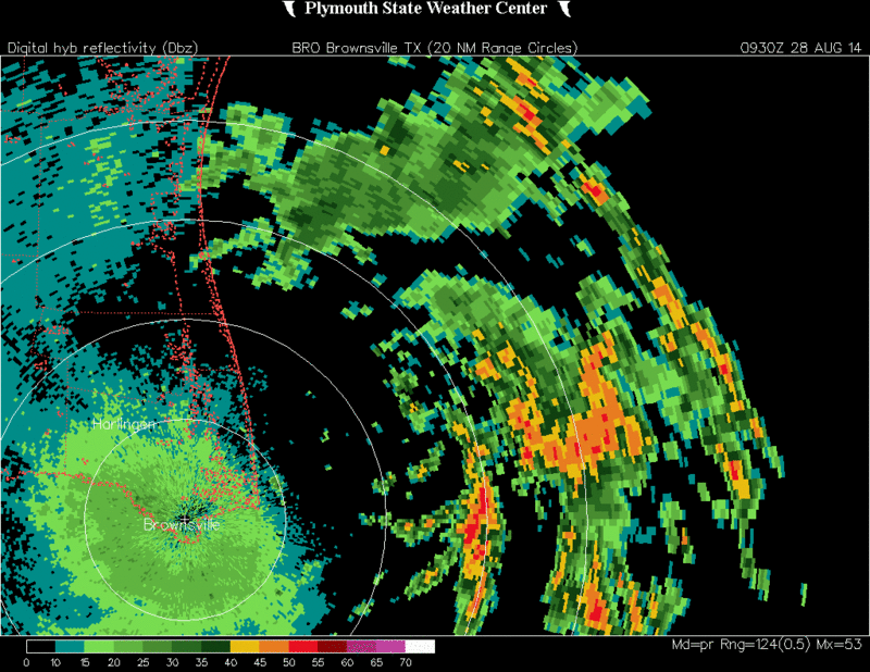
Re: ATL: INVEST 98L - Discussion
kicking it's heels up again this morning. radar out of Brownsville
http://radar.weather.gov/radar.php?prod ... O&loop=yes
http://radar.weather.gov/radar.php?prod ... O&loop=yes
0 likes
The following post is NOT an official forecast and should not be used as such. It is just the opinion of the poster and may or may not be backed by sound meteorological data. It is NOT endorsed by any professional institution including storm2k.org For Official Information please refer to the NHC and NWS products.
-
somethingfunny

- ChatStaff

- Posts: 3926
- Age: 35
- Joined: Thu May 31, 2007 10:30 pm
- Location: McKinney, Texas
Re:
The only hope this thing has for development is getting rid of that upper level low, but at least it will still produce some rain - just not as widespread as a tropical cyclone would
0 likes
I am not a meteorologist, and any posts made by me are not official forecasts or to be interpreted as being intelligent. These posts are just my opinions and are probably silly opinions.

Re: ATL: INVEST 98L - Discussion
This thing has a chance. Close to the coast but as long as it is 5 miles offshore it can go...see Jerry 05...Beryl '04
0 likes
-
jaguarjace

- Category 4

- Posts: 975
- Age: 29
- Joined: Sat Jun 11, 2011 7:38 am
- Location: Khon Kaen, Thailand
Re: ATL: INVEST 98L - Discussion
Getting it's convection going again.

0 likes
Owner of the Tropical Archive YouTube channel
Web Developer at Force Thirteen
Twitter/X : @force13_support
Web Developer at Force Thirteen
Twitter/X : @force13_support
-
cycloneye
- Admin
- Posts: 139086
- Age: 67
- Joined: Thu Oct 10, 2002 10:54 am
- Location: San Juan, Puerto Rico
Re: ATL: INVEST 98L - Discussion
A weak area of low pressure near the coast of South Texas is
producing disorganized showers and thunderstorms. Significant
development of this system is unlikely before it moves inland over
South Texas and northern Mexico today.
* Formation chance through 48 hours...low...10 percent.
* Formation chance through 5 days...low...10 percent.
producing disorganized showers and thunderstorms. Significant
development of this system is unlikely before it moves inland over
South Texas and northern Mexico today.
* Formation chance through 48 hours...low...10 percent.
* Formation chance through 5 days...low...10 percent.
0 likes
Visit the Caribbean-Central America Weather Thread where you can find at first post web cams,radars
and observations from Caribbean basin members Click Here
and observations from Caribbean basin members Click Here

Re: ATL: INVEST 98L - Discussion
COC seems to be a good 30-40 miles offshore, not moving much this morning, NE of Brownsville.
0 likes
-
tolakram
- Admin
- Posts: 19165
- Age: 60
- Joined: Sun Aug 27, 2006 8:23 pm
- Location: Florence, KY (name is Mark)
Re: ATL: INVEST 98L - Discussion
Unenhanced live IR loop, waiting impatiently for the sun to rise.
http://wwwghcc.msfc.nasa.gov/cgi-bin/get-goes?satellite=GOES-E%20CONUS&lat=27&lon=-94&info=ir&zoom=1&width=1000&height=800&quality=95&type=Animation&palette=ir1.pal&numframes=15
Part of the circulation appears to be coming ashore.
http://wwwghcc.msfc.nasa.gov/cgi-bin/get-goes?satellite=GOES-E%20CONUS&lat=27&lon=-94&info=ir&zoom=1&width=1000&height=800&quality=95&type=Animation&palette=ir1.pal&numframes=15
Part of the circulation appears to be coming ashore.
0 likes
M a r k
- - - - -
Join us in chat: Storm2K Chatroom Invite. Android and IOS apps also available.
The posts in this forum are NOT official forecasts and should not be used as such. Posts are NOT endorsed by any professional institution or STORM2K.org. For official information and forecasts, please refer to NHC and NWS products.
-
Portastorm

- Storm2k Moderator

- Posts: 9787
- Age: 61
- Joined: Fri Jul 11, 2003 9:16 am
- Location: South Austin, TX
- Contact:
Re: ATL: INVEST 98L - Discussion
As Steve reminded us in this thread a day or two ago, the classic "tightening up before it hits the Texas coast" scenario is playing out somewhat. Wonder what would have happened if 98L had another day or two.
0 likes
Any forecasts under my name are to be taken with a grain of salt. Get your best forecasts from the National Weather Service and National Hurricane Center.
I'm a certified Advanced SKYWARN-trained spotter and am active on Twitter at @TravisCOSW, a social media partner of the NWS Austin-San Antonio office.
I'm a certified Advanced SKYWARN-trained spotter and am active on Twitter at @TravisCOSW, a social media partner of the NWS Austin-San Antonio office.
Who is online
Users browsing this forum: No registered users and 96 guests