I think it is possibly close to TD status. Unless it lingers longer offshore than expected, I don't think the NHC will upgrade.
The following post is NOT an official forecast and should not be used as such. It is just the opinion of the poster and may or may not be backed by sound meteorological data. It is NOT endorsed by any professional institution including storm2k.org For Official Information please refer to the NHC and NWS products.
ATL: INVEST 98L - Discussion
Moderator: S2k Moderators
-
tropicwatch

- Category 5

- Posts: 3205
- Age: 60
- Joined: Sat Jun 02, 2007 10:01 am
- Location: Panama City Florida
- Contact:
0 likes
Tropicwatch
Agnes 72', Eloise 75, Elena 85', Kate 85', Charley 86', Florence 88', Beryl 94', Dean 95', Erin 95', Opal 95', Earl 98', Georges 98', Ivan 2004', Arlene 2005', Dennis 2005', Ida 2009' Debby 2012' Irma 2017' Michael 2018'
Agnes 72', Eloise 75, Elena 85', Kate 85', Charley 86', Florence 88', Beryl 94', Dean 95', Erin 95', Opal 95', Earl 98', Georges 98', Ivan 2004', Arlene 2005', Dennis 2005', Ida 2009' Debby 2012' Irma 2017' Michael 2018'

-
cycloneye

- Admin

- Posts: 139154
- Age: 67
- Joined: Thu Oct 10, 2002 10:54 am
- Location: San Juan, Puerto Rico
Re: ATL: INVEST 98L - Discussion
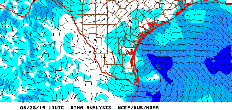
12z Best Track.
98L INVEST 140828 1200 26.2N 96.7W ATL 25 1009
98L INVEST 140828 1200 26.2N 96.7W ATL 25 1009
0 likes
Visit the Caribbean-Central America Weather Thread where you can find at first post web cams,radars
and observations from Caribbean basin members Click Here
and observations from Caribbean basin members Click Here
-
tolakram
- Admin
- Posts: 19165
- Age: 60
- Joined: Sun Aug 27, 2006 8:23 pm
- Location: Florence, KY (name is Mark)
Re: ATL: INVEST 98L - Discussion
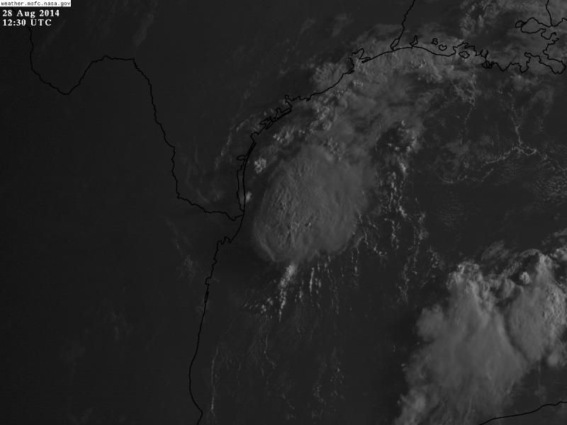
Live visible, 2 frames visible anyway.
http://wwwghcc.msfc.nasa.gov/cgi-bin/get-goes?satellite=GOES-E%20CONUS&lat=26&lon=-96&info=vis&zoom=1&width=1000&height=800&quality=95&type=Animation&palette=ir1.pal&numframes=5
If you all weren't on central time it would be light by now!
http://wwwghcc.msfc.nasa.gov/cgi-bin/get-goes?satellite=GOES-E%20CONUS&lat=26&lon=-96&info=vis&zoom=1&width=1000&height=800&quality=95&type=Animation&palette=ir1.pal&numframes=5
If you all weren't on central time it would be light by now!
0 likes
M a r k
- - - - -
Join us in chat: Storm2K Chatroom Invite. Android and IOS apps also available.
The posts in this forum are NOT official forecasts and should not be used as such. Posts are NOT endorsed by any professional institution or STORM2K.org. For official information and forecasts, please refer to NHC and NWS products.
-
Dean4Storms
- S2K Supporter

- Posts: 6355
- Age: 61
- Joined: Sun Aug 31, 2003 1:01 pm
- Location: Miramar Bch. FL
Re: ATL: INVEST 98L - Discussion
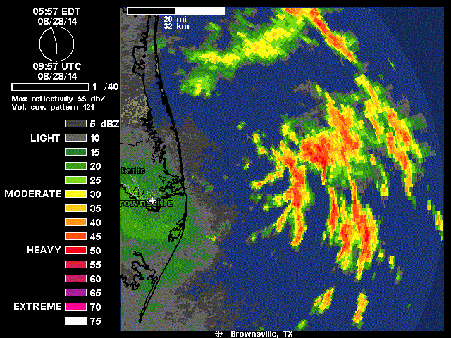
Looks like it is close to TC formation if not already there this morning....
http://radar.weather.gov/ridge/radar.php?rid=BRO&product=N0R&overlay=11101111&loop=yes
http://radar.weather.gov/ridge/radar.php?rid=BRO&product=N0R&overlay=11101111&loop=yes
0 likes

Re: ATL: INVEST 98L - Discussion
Dean4Storms wrote:Looks like it is close to TC formation if not already there this morning....
http://radar.weather.gov/ridge/radar.php?rid=BRO&product=N0R&overlay=11101111&loop=yes
The low-level center is well west of the mid-level center/convective ball. Expect this to collapse in next few hours with low-level swirl moving inland later today.
0 likes
-
srainhoutx

- S2K Supporter
- Posts: 6919
- Age: 66
- Joined: Sun Jan 14, 2007 11:34 am
- Location: Haywood County, NC
- Contact:
Re: ATL: INVEST 98L - Discussion
wxsouth wrote:Dean4Storms wrote:Looks like it is close to TC formation if not already there this morning....
http://radar.weather.gov/ridge/radar.php?rid=BRO&product=N0R&overlay=11101111&loop=yes
The low-level center is well west of the mid-level center/convective ball. Expect this to collapse in next few hours with low-level swirl moving inland later today.
The weak llc is near Port Mansfield about to cross Padre Island. The mid level vort is where all the deeper convection is firing under westerly shear.
0 likes
Carla/Alicia/Jerry(In The Eye)/Michelle/Charley/Ivan/Dennis/Katrina/Rita/Wilma/Ike/Harvey
Member: National Weather Association
Wx Infinity Forums
http://wxinfinity.com/index.php
Facebook.com/WeatherInfinity
Twitter @WeatherInfinity
Member: National Weather Association
Wx Infinity Forums
http://wxinfinity.com/index.php
Facebook.com/WeatherInfinity
Twitter @WeatherInfinity
-
Stormcenter
- S2K Supporter
- Posts: 6617
- Joined: Wed Sep 03, 2003 11:27 am
- Location: Houston, TX
Something may end up developing in the GOM later this weekend other 98L. IMO
http://www.ssd.noaa.gov/goes/east/gmex/flash-avn.html
http://www.ssd.noaa.gov/goes/east/gmex/flash-avn.html
0 likes
-
tolakram
- Admin
- Posts: 19165
- Age: 60
- Joined: Sun Aug 27, 2006 8:23 pm
- Location: Florence, KY (name is Mark)
Re: ATL: INVEST 98L - Discussion
saved loop
0 likes
M a r k
- - - - -
Join us in chat: Storm2K Chatroom Invite. Android and IOS apps also available.
The posts in this forum are NOT official forecasts and should not be used as such. Posts are NOT endorsed by any professional institution or STORM2K.org. For official information and forecasts, please refer to NHC and NWS products.
- - - - -
Join us in chat: Storm2K Chatroom Invite. Android and IOS apps also available.
The posts in this forum are NOT official forecasts and should not be used as such. Posts are NOT endorsed by any professional institution or STORM2K.org. For official information and forecasts, please refer to NHC and NWS products.
Re: ATL: INVEST 98L - Discussion
wxsouth wrote:Dean4Storms wrote:Looks like it is close to TC formation if not already there this morning....
http://radar.weather.gov/ridge/radar.php?rid=BRO&product=N0R&overlay=11101111&loop=yes
The low-level center is well west of the mid-level center/convective ball. Expect this to collapse in next few hours with low-level swirl moving inland later today.
Yeah, interesting how the mid level vort-max has been pushing SE leaving the low level swirl behind, like you say is probably going to collapse as the day goes by.
0 likes

That's a good possibility Stormcenter. Piling up of energy and a backing out boundary? Pattern reversal. Models weren't really showing anything yesterday that would be immediate, but disturbed weather in the Gulf in August almost always has to be watched. Looks like a run of Western Gulf possibilities for the next few weeks. Over the last 5 years, every year but 2009 featured activity in the Western Gulf (primarily the BoC).
0 likes
Re: ATL: INVEST 98L - Discussion
This formed from a trough remnant that dropped into the Gulf.
0 likes
Right, it was the butt end. There is a remaining boundary that should back north with the likelihood of anything forming being either along/out front or directly in the wake of the backing trough. North American Model last night showed it kind of as a triple surge (not necessarily the triple surge I've been talking about which would end up being a quadruple if something stronger got going 7-10 days out). And not that I trust it, but sometimes it hits the sim radar pretty well.
http://mag.ncep.noaa.gov/model-guidance ... roup=Model Guidance&model=nam&area=namer&cycle=20140828%2012%20UTC¶m=sim_radar&fourpan=no&imageSize=M&ps=model
Okay, so NAM 12Z is still running but the 6z shows another surge moving toward the TX Coast with some apparent rotation on the radar and then something maybe stronger (?) nearing the Yucatan in 4 days from the run. Clues only of course.
0 likes
-
tropicwatch
- Category 5
- Posts: 3205
- Age: 60
- Joined: Sat Jun 02, 2007 10:01 am
- Location: Panama City Florida
- Contact:
Think the MLC will dissipate or could it sink to the surface?
0 likes
Tropicwatch
Agnes 72', Eloise 75, Elena 85', Kate 85', Charley 86', Florence 88', Beryl 94', Dean 95', Erin 95', Opal 95', Earl 98', Georges 98', Ivan 2004', Arlene 2005', Dennis 2005', Ida 2009' Debby 2012' Irma 2017' Michael 2018'
Agnes 72', Eloise 75, Elena 85', Kate 85', Charley 86', Florence 88', Beryl 94', Dean 95', Erin 95', Opal 95', Earl 98', Georges 98', Ivan 2004', Arlene 2005', Dennis 2005', Ida 2009' Debby 2012' Irma 2017' Michael 2018'

Re: ATL: INVEST 98L - Discussion
panamatropicwatch wrote:Think the MLC will dissipate or could it sink to the surface?
Typically, MLCs without any low-level support will dissipate on their own. However, there does look to be some low-level inflow toward the area of deep convection, which would be needed for a low-level circulation to develop there. Overall, however, I think the odds are non-negligible, but slim. The most likely scenario is that the LLC moves inland into South Texas in the next few hours and the convection over the Gulf dissipates.
0 likes


-
Stormcenter
- S2K Supporter
- Posts: 6617
- Joined: Wed Sep 03, 2003 11:27 am
- Location: Houston, TX
-
Dean4Storms
- S2K Supporter
- Posts: 6355
- Age: 61
- Joined: Sun Aug 31, 2003 1:01 pm
- Location: Miramar Bch. FL
Who is online
Users browsing this forum: No registered users and 49 guests