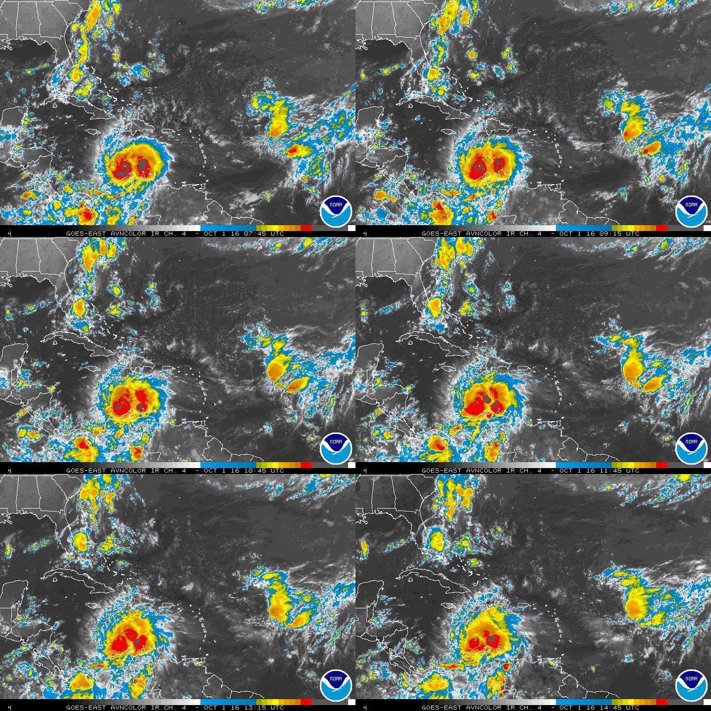
ATL: INVEST 92L - Discussion
Moderator: S2k Moderators
Re: ATL: INVEST 92L - Discussion
It might have a low chance if the ULL can out run it moving westward. but as long as it's to the east or over 92L it's doomed
0 likes
The following post is NOT an official forecast and should not be used as such. It is just the opinion of the poster and may or may not be backed by sound meteorological data. It is NOT endorsed by any professional institution including storm2k.org For Official Information please refer to the NHC and NWS products.
- HouTXmetro
- Category 5

- Posts: 3949
- Joined: Sun Jun 13, 2004 6:00 pm
- Location: District of Columbia, USA
-
Stormcenter
- S2K Supporter

- Posts: 6617
- Joined: Wed Sep 03, 2003 11:27 am
- Location: Houston, TX
Starting to fire a small amount of convection and trying to wrap
it around. Is this going to be the "Little Engine that Could" or is the big bad wolf going to huff and puff and blow his house down
it around. Is this going to be the "Little Engine that Could" or is the big bad wolf going to huff and puff and blow his house down
0 likes
The following post is NOT an official forecast and should not be used as such. It is just the opinion of the poster and may or may not be backed by sound meteorological data. It is NOT endorsed by storm2k.org.
- HouTXmetro
- Category 5

- Posts: 3949
- Joined: Sun Jun 13, 2004 6:00 pm
- Location: District of Columbia, USA
Re: ATL: INVEST 92L - Discussion
Those last few looks like it might be opening up. I just don't see how it can sustain itself void of convection.
0 likes
[Disclaimer: My Amateur Opinion, please defer to your local authorities or the NHC for Guidance.]
-
Craters
- Category 1

- Posts: 349
- Joined: Sat Aug 24, 2013 2:34 pm
- Location: Alvin, TX (south of Houston)
Re: ATL: INVEST 92L - Discussion
Not wanting to get off topic or anything, but does anybody remember so many potential storms getting clobbered by dry air in one season, or is it just me? Last year was pretty bad, but I don't remember it being like this.
Looks to me like 92L can't even keep its LLC going without it reforming now.
Looks to me like 92L can't even keep its LLC going without it reforming now.
0 likes
Nothing that I post here should ever be treated as a forecast or anything resembling one. Please check with your local NWS office or the NHC for forecasts, watches, and warnings.
- tropicwatch
- Category 5

- Posts: 3205
- Age: 60
- Joined: Sat Jun 02, 2007 10:01 am
- Location: Panama City Florida
- Contact:
There is that one band of 20kt wind shear that has stayed with 92L all day.


0 likes
Tropicwatch
Agnes 72', Eloise 75, Elena 85', Kate 85', Charley 86', Florence 88', Beryl 94', Dean 95', Erin 95', Opal 95', Earl 98', Georges 98', Ivan 2004', Arlene 2005', Dennis 2005', Ida 2009' Debby 2012' Irma 2017' Michael 2018'
Agnes 72', Eloise 75, Elena 85', Kate 85', Charley 86', Florence 88', Beryl 94', Dean 95', Erin 95', Opal 95', Earl 98', Georges 98', Ivan 2004', Arlene 2005', Dennis 2005', Ida 2009' Debby 2012' Irma 2017' Michael 2018'
Re: ATL: INVEST 92L - Discussion
The Atlantic has been dry with lots of SAL but the gulf of Mexico was moist until This ULL pulled all the dry air down.
Without convection 92L is just spreading out Buoy 42003 is off line but 42001 at mid gulf shows pressure of 1014 mb's.
Pressure gradient might be getting too shallow but we won't know till it passes the mid gulf buoy.
http://www.ndbc.noaa.gov/station_page.php?station=42001
I'll guess 1012 mb's with winds under 20 knots before the wind flip.
0 likes
- wxman57
- Moderator-Pro Met

- Posts: 22482
- Age: 66
- Joined: Sat Jun 21, 2003 8:06 pm
- Location: Houston, TX (southwest)
Re: ATL: INVEST 92L - Discussion
Looks like 92L is history. Very little (if any) low-level convergence. Swirl is weakening. I don't think it will survive to reach Texas.
0 likes
Re: ATL: INVEST 92L - Discussion

0 likes
The following post is NOT an official forecast and should not be used as such. It is just the opinion of the poster and may or may not be backed by sound meteorological data. It is NOT endorsed by storm2k.org.
-
floridasun78
- Category 5

- Posts: 3755
- Joined: Sun May 17, 2009 10:16 pm
- Location: miami fl
Re: ATL: INVEST 92L - Discussion
wxman57 wrote:Looks like 92L is history. Very little (if any) low-level convergence. Swirl is weakening. I don't think it will survive to reach Texas.
i agree it over 92l
0 likes
- tropicwatch
- Category 5

- Posts: 3205
- Age: 60
- Joined: Sat Jun 02, 2007 10:01 am
- Location: Panama City Florida
- Contact:
The front has stalled and moisture is moving south into the gulf. I wander if 92L will benefit from it.


0 likes
Tropicwatch
Agnes 72', Eloise 75, Elena 85', Kate 85', Charley 86', Florence 88', Beryl 94', Dean 95', Erin 95', Opal 95', Earl 98', Georges 98', Ivan 2004', Arlene 2005', Dennis 2005', Ida 2009' Debby 2012' Irma 2017' Michael 2018'
Agnes 72', Eloise 75, Elena 85', Kate 85', Charley 86', Florence 88', Beryl 94', Dean 95', Erin 95', Opal 95', Earl 98', Georges 98', Ivan 2004', Arlene 2005', Dennis 2005', Ida 2009' Debby 2012' Irma 2017' Michael 2018'
Re:
panamatropicwatch wrote:The front has stalled and moisture is moving south into the gulf. I wander if 92L will benefit from it.
I believe it is a little too late. 92L tried all day but it's done in my opinion.
0 likes
-
TARHEELPROGRAMMER
Re:
TARHEELPROGRAMMER wrote:I have a feeling this thing is going to ramp up again. Looks like moisture is being pulled to it from all sides now.
A few of the models do in fact have this developing about 2-3 days out once it gets close to the Texas coast.
0 likes
The above post is not official and should not be used as such. It is the opinion of the poster and may or may not be backed by sound meteorological data. It is not endorsed by any professional institution or storm2k.org. For official information, please refer to the NHC and NWS products.
-
TARHEELPROGRAMMER
Re: Re:
Hammy wrote:TARHEELPROGRAMMER wrote:I have a feeling this thing is going to ramp up again. Looks like moisture is being pulled to it from all sides now.
A few of the models do in fact have this developing about 2-3 days out once it gets close to the Texas coast.
I think it will show signs of developing and looking more impressive by tomorrow morning. The shear is bad where it is now but that feature to its east is approaching faster and bringing moisture and that front to the north just broke off a piece of moisture.
0 likes
- cycloneye
- Admin

- Posts: 139122
- Age: 67
- Joined: Thu Oct 10, 2002 10:54 am
- Location: San Juan, Puerto Rico
Re: ATL: INVEST 92L - Discussion
The area of low pressure located over the east-central Gulf of
Mexico has continued to become less defined this afternoon and the
associated shower activity is minimal. Upper-level winds are not
conducive for development, and the low will most likely degenerate
into a trough of low pressure while it moves westward across the
Gulf of Mexico during the next few days.
* Formation chance through 48 hours...low...near 0 percent.
* Formation chance through 5 days...low...near 0 percent.
0 likes
Visit the Caribbean-Central America Weather Thread where you can find at first post web cams,radars
and observations from Caribbean basin members Click Here
and observations from Caribbean basin members Click Here
- Rail Dawg
- S2K Supporter

- Posts: 308
- Joined: Mon Aug 27, 2012 5:02 pm
- Location: Where the eye makes landfall.
Re: ATL: INVEST 92L - Discussion
I flew right past this disturbance as a pilot twice today. Heading east in the afternoon it seemed to have collapsed quite a bit. Earlier this morning it was much more concentrated and we diverted north quite a bit.
Chuck
Chuck
0 likes
Although I have been a hurricane forecaster since 1980 that only means I've been wrong lots of times.
-
TARHEELPROGRAMMER
Who is online
Users browsing this forum: No registered users and 58 guests


