ATL: DORIAN - Post-Tropical - Discussion

Moderator: S2k Moderators

Message
Author
User avatar
Blown Away
S2K Supporter
S2K Supporter
Posts: 10147
Joined: Wed May 26, 2004 6:17 am

Re: ATL: DORIAN - Models

#1001 Postby Blown Away » Thu Jul 25, 2013 6:29 am

jlauderdal wrote:
Blown Away wrote:06z GFS...Landfall SFL
http://www.tropicaltidbits.com/analysis ... opics.html


how many times have we been hit on model runs, wilma 2005 last time we were actually hit and that was from the west of all places..one of these days though.. BAM POW SMACKED... :grrr:


I think it's a conspiracy to increase the browsing numbers on this board, now all those GOMER people will start hanging around... :D
0 likes   
Hurricane Eye Experience: David 79, Irene 99, Frances 04, Jeanne 04, Wilma 05... EYE COMING MY WAY IN 2024…
Hurricane Brush Experience: Andrew 92, Erin 95, Floyd 99, Matthew 16, Irma 17, Ian 22, Nicole 22…

User avatar
senorpepr
Military Met/Moderator
Posts: 12542
Age: 43
Joined: Fri Aug 22, 2003 9:22 pm
Location: Mackenbach, Germany
Contact:

Re: ATL: DORIAN - Tropical Storm - Discussion

#1002 Postby senorpepr » Thu Jul 25, 2013 6:30 am

Quick video update on Tropical Storms Dorian and Flossie, as well as other interests around the world. Plenty of uncertainty in the long-term forecast for Dorian... will it survive the trek across the Atlantic?

[youtube]http://www.youtube.com/watch?v=EtZiX3SN7x8[/youtube]
0 likes   

TheStormExpert

#1003 Postby TheStormExpert » Thu Jul 25, 2013 6:33 am

What an interesting run the 6z GFS was! I just don't see it managing to hit Florida. The farthest west I could see it going is through the Bahamas like Irene of 2011 and try and go out to sea while maybe scraping the outer banks of NC. Just my forecast though...
0 likes   

tolakram
Admin
Admin
Posts: 20010
Age: 62
Joined: Sun Aug 27, 2006 8:23 pm
Location: Florence, KY (name is Mark)

Re: ATL: DORIAN - Tropical Storm - Discussion

#1004 Postby tolakram » Thu Jul 25, 2013 6:34 am

0 likes   
M a r k
- - - - -
Join us in chat: Storm2K Chatroom Invite. Android and IOS apps also available.

The posts in this forum are NOT official forecasts and should not be used as such. Posts are NOT endorsed by any professional institution or STORM2K.org. For official information and forecasts, please refer to NHC and NWS products.

User avatar
GCANE
S2K Supporter
S2K Supporter
Posts: 11497
Joined: Mon Oct 22, 2007 8:03 am

Re: ATL: DORIAN - Tropical Storm - Discussion

#1005 Postby GCANE » Thu Jul 25, 2013 6:35 am

0 likes   

tolakram
Admin
Admin
Posts: 20010
Age: 62
Joined: Sun Aug 27, 2006 8:23 pm
Location: Florence, KY (name is Mark)

Re: ATL: DORIAN - Tropical Storm - Discussion

#1006 Postby tolakram » Thu Jul 25, 2013 6:36 am

FYI the floater may be able to use the HURRICANE sector images later today, hopefully. My live link is the extended sector view and that's the maximum magnification.
0 likes   
M a r k
- - - - -
Join us in chat: Storm2K Chatroom Invite. Android and IOS apps also available.

The posts in this forum are NOT official forecasts and should not be used as such. Posts are NOT endorsed by any professional institution or STORM2K.org. For official information and forecasts, please refer to NHC and NWS products.

Stormlover2012
Category 1
Category 1
Posts: 262
Joined: Sat Jun 23, 2012 11:03 am

Re: ATL: DORIAN - Models

#1007 Postby Stormlover2012 » Thu Jul 25, 2013 6:36 am

Why wouldn't this run be just as good as the others how many times have models runs show east coast and then boom it gets in the gom. Ike,Rita,Katrina, Gustavo, u can't trust model runs this for out.
0 likes   

User avatar
NDG
S2K Supporter
S2K Supporter
Posts: 15446
Joined: Sun Jul 09, 2006 10:14 pm
Location: Orlando, FL

Re: ATL: DORIAN - Tropical Storm - Discussion

#1008 Postby NDG » Thu Jul 25, 2013 6:36 am

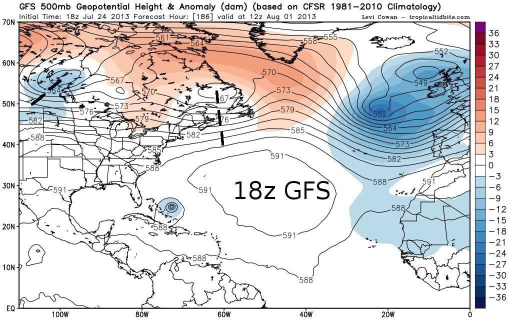
The trend by the GFS is for a stronger Bermuda ridge at H50 for early next week and wanting to bridge westwards towards the Bahamas and FL for at least a quick momment, thus why the GFS has been trending westwards.
If you look at the models from a few days ago you can see that they were forecasting the Bermuda ridge to not be as strong and as westwards as they are not forecasting it to be from Sunday-Thursday time frame.
But what complicates things is that the pattern is going to be fairly flat across the northern US by the middle to late next week hard to tell exactly what Dorian will do by then. We many not exactly know until at least this weekend, until then I can see the GFS flip-flopping.
0 likes   

tolakram
Admin
Admin
Posts: 20010
Age: 62
Joined: Sun Aug 27, 2006 8:23 pm
Location: Florence, KY (name is Mark)

Re: ATL: DORIAN - Tropical Storm - Discussion

#1009 Postby tolakram » Thu Jul 25, 2013 6:38 am

0 likes   
M a r k
- - - - -
Join us in chat: Storm2K Chatroom Invite. Android and IOS apps also available.

The posts in this forum are NOT official forecasts and should not be used as such. Posts are NOT endorsed by any professional institution or STORM2K.org. For official information and forecasts, please refer to NHC and NWS products.

User avatar
GCANE
S2K Supporter
S2K Supporter
Posts: 11497
Joined: Mon Oct 22, 2007 8:03 am

Re: ATL: DORIAN - Tropical Storm - Discussion

#1010 Postby GCANE » Thu Jul 25, 2013 6:43 am

Small cell, but firing right over the LLC

http://rammb.cira.colostate.edu/product ... 250500.jpg
0 likes   

User avatar
GCANE
S2K Supporter
S2K Supporter
Posts: 11497
Joined: Mon Oct 22, 2007 8:03 am

Re: ATL: DORIAN - Tropical Storm - Discussion

#1011 Postby GCANE » Thu Jul 25, 2013 6:48 am

Anti-cyclone has repositioned itself to the west of the LLC.

Dorian will be tracking into it.

Also a large slot of increasing tropopause height for the vortex column to expand vertically and spin up.

Just about the same conditions 36 hrs ago when it ramped up.

Looks like more strengthening.
0 likes   

RL3AO
Moderator-Pro Met
Moderator-Pro Met
Posts: 16308
Joined: Thu Jun 14, 2007 10:03 pm
Location: NC

#1012 Postby RL3AO » Thu Jul 25, 2013 6:48 am

Image

Image

6z GFS is faster with the shortwaves. Also, I notice there is a more zonal flow off the east coast on the 6z run, where on the 18z run you have a SW flow off the coast of NC/VA.
0 likes   

User avatar
cycloneye
Admin
Admin
Posts: 145366
Age: 68
Joined: Thu Oct 10, 2002 10:54 am
Location: San Juan, Puerto Rico

Re: ATL: DORIAN - Tropical Storm - Discussion

#1013 Postby cycloneye » Thu Jul 25, 2013 6:50 am

12z Best Track remains at 50kts.

AL, 04, 2013072512, , BEST, 0, 157N, 352W, 50, 999, TS
0 likes   
Visit the Caribbean-Central America Weather Thread where you can find at first post web cams,radars
and observations from Caribbean basin members Click Here

User avatar
Blown Away
S2K Supporter
S2K Supporter
Posts: 10147
Joined: Wed May 26, 2004 6:17 am

Re: ATL: DORIAN - Models

#1014 Postby Blown Away » Thu Jul 25, 2013 6:55 am

:uarrow: RL3AO Great summary!!
Stormlover2012 wrote:Why wouldn't this run be just as good as the others how many times have models runs show east coast and then boom it gets in the gom. Ike,Rita,Katrina, Gustavo, u can't trust model runs this for out.


Being 200 hours out, you take from these GFS runs that Dorian will generally be in the area in 7-9 days and really not a big swing as from previous runs, it's just the recurve occurred a little farther W. A few degrees longitude east or west past 70W will be the difference between E coast runner and sneaking into the GOM.
0 likes   
Hurricane Eye Experience: David 79, Irene 99, Frances 04, Jeanne 04, Wilma 05... EYE COMING MY WAY IN 2024…
Hurricane Brush Experience: Andrew 92, Erin 95, Floyd 99, Matthew 16, Irma 17, Ian 22, Nicole 22…

tolakram
Admin
Admin
Posts: 20010
Age: 62
Joined: Sun Aug 27, 2006 8:23 pm
Location: Florence, KY (name is Mark)

Re: ATL: DORIAN - Models

#1015 Postby tolakram » Thu Jul 25, 2013 7:12 am

6z GFS, saved image. A weak low off Florida that dissipates in the next frame. You can track low pressure over Florida into the gulf, but nothing organized.

Image
0 likes   
M a r k
- - - - -
Join us in chat: Storm2K Chatroom Invite. Android and IOS apps also available.

The posts in this forum are NOT official forecasts and should not be used as such. Posts are NOT endorsed by any professional institution or STORM2K.org. For official information and forecasts, please refer to NHC and NWS products.

User avatar
Blown Away
S2K Supporter
S2K Supporter
Posts: 10147
Joined: Wed May 26, 2004 6:17 am

Re: ATL: DORIAN - Models

#1016 Postby Blown Away » Thu Jul 25, 2013 7:14 am

Image
12z
Image
Last edited by Blown Away on Thu Jul 25, 2013 7:18 am, edited 1 time in total.
0 likes   
Hurricane Eye Experience: David 79, Irene 99, Frances 04, Jeanne 04, Wilma 05... EYE COMING MY WAY IN 2024…
Hurricane Brush Experience: Andrew 92, Erin 95, Floyd 99, Matthew 16, Irma 17, Ian 22, Nicole 22…

tolakram
Admin
Admin
Posts: 20010
Age: 62
Joined: Sun Aug 27, 2006 8:23 pm
Location: Florence, KY (name is Mark)

Re: ATL: DORIAN - Models

#1017 Postby tolakram » Thu Jul 25, 2013 7:15 am

I think the 6Z is a broken run, so looking forward for the first real run with the new GFS.

Here is a few frames earlier, as posted above, with a 993 MB storm in the Bahamas.

Image
0 likes   
M a r k
- - - - -
Join us in chat: Storm2K Chatroom Invite. Android and IOS apps also available.

The posts in this forum are NOT official forecasts and should not be used as such. Posts are NOT endorsed by any professional institution or STORM2K.org. For official information and forecasts, please refer to NHC and NWS products.

Frank2
Category 5
Category 5
Posts: 4061
Joined: Mon Jul 25, 2005 12:47 pm

Re: ATL: DORIAN - Tropical Storm - Discussion

#1018 Postby Frank2 » Thu Jul 25, 2013 7:18 am

AFTER THAT...DORIAN SHOULD
APPROACH A WEAKNESS IN THE RIDGE...WHICH SHOULD LEAD TO A
WEST-NORTHWESTWARD MOTION AT A DECREASED FORWARD SPEED. THE
GUIDANCE ENVELOPE HAS SHIFTED A BIT TO THE NORTH SINCE THE PREVIOUS
ADVISORY. BASED ON THIS...THE NEW FORECAST TRACK WILL BE NUDGED A
LITTLE TO THE NORTH...


How do you spell fish (lol) - it's already at 16N so just a guess based on past storms the chance of a recurve is pretty high - the trough over the south is forecast to remain the next few days so that'll only increase the chance of a recurving system, Bermuda high or no...

Personal Forecast Disclaimer:
The posts in this forum are NOT official forecast and should not be used as such. They are just the opinion of the poster and may or may not be backed by sound meteorological data. They are NOT endorsed by any professional institution or storm2k.org. For official information, please refer to the NHC and NWS products.
Last edited by Frank2 on Thu Jul 25, 2013 7:20 am, edited 2 times in total.
0 likes   

User avatar
Gustywind
Category 5
Category 5
Posts: 12334
Joined: Mon Sep 03, 2007 7:29 am
Location: Baie-Mahault, GUADELOUPE

#1019 Postby Gustywind » Thu Jul 25, 2013 7:18 am

8 AM TWD.

BASED ON 0600 UTC SURFACE ANALYSIS AND SATELLITE IMAGERY THROUGH
0945 UTC.

...SPECIAL FEATURE...
TROPICAL STORM DORIAN IS CENTERED NEAR 15.6N 34.5W AT 25/0900
UTC OR ABOUT 610 NM W OF THE CAPE VERDE ISLANDS MOVING W-NW AT
15 KT. MAXIMUM SUSTAINED WIND SPEED IS 50 KT WITH GUSTS TO 60
KT. MINIMUM CENTRAL PRESSURE IS 999 MB. PLEASE SEE THE FORECAST/
ADVISORY UNDER AWIPS/WMO HEADERS MIATCMAT4/WTNT24 KNHC AND THE
PUBLIC ADVISORY UNDER AWIPS/WMO HEADERS MIATCPAT4/WTNT34 KNHC
FOR MORE DETAILS. CLUSTERS OF SCATTERED MODERATE/ISOLATED STRONG
CONVECTION ARE FROM 13N-17N BETWEEN 32W-36W.
0 likes   

User avatar
Blown Away
S2K Supporter
S2K Supporter
Posts: 10147
Joined: Wed May 26, 2004 6:17 am

Re: ATL: DORIAN - Tropical Storm - Discussion

#1020 Postby Blown Away » Thu Jul 25, 2013 7:25 am

Image
Wow, look at the shear at 120 hours!!
ftp://ftp.nhc.noaa.gov/atcf/stext/13072 ... _ships.txt
0 likes   
Hurricane Eye Experience: David 79, Irene 99, Frances 04, Jeanne 04, Wilma 05... EYE COMING MY WAY IN 2024…
Hurricane Brush Experience: Andrew 92, Erin 95, Floyd 99, Matthew 16, Irma 17, Ian 22, Nicole 22…


Return to “2013”

Who is online

Users browsing this forum: No registered users and 11 guests