up to 120 kts. Although I believe it's a little stronger than that, perhaps at about 130 kts. Category 5 is a possibility...
WDPN32 PGTW 190900
MSGID/GENADMIN/JOINT TYPHOON WRNCEN PEARL HARBOR HI//
SUBJ/PROGNOSTIC REASONING FOR TYPHOON 17W (USAGI) WARNING NR 11//
RMKS//
1. FOR METEOROLOGISTS.
2. 6 HOUR SUMMARY AND ANALYSIS.
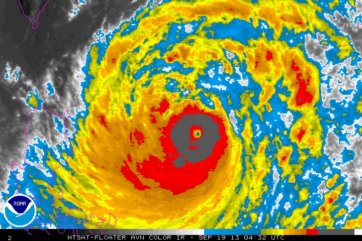
TYPHOON (TY) 17W (USAGI), LOCATED APPROXIMATELY 442 NM EAST-
NORTHEAST OF MANILA, PHILIPPINES, HAS TRACKED NORTHWESTWARD AT 08
KNOTS OVER THE PAST SIX HOURS. TY 17W HAS RAPIDLY INTENSIFIED OVER
THE PAST 24 HOURS WITH A 65-KNOT INCREASE IN MAXIMUM SUSTAINED
WINDS. ADDITIONALLY, ANIMATED MULTISPECTRAL SATELLITE IMAGERY (MSI)
INDICATES RAPID INTENSIFICATION (RI) OVER JUST THE PAST SIX HOURS
WITH FORMATION OF A ROUND 20-NM EYE AND AN INTENSE, SYMMETRIC
EYEWALL. TY 17W HAS ALSO TRACKED NORTHWESTWARD AFTER A SHORT PERIOD
OF ERRATIC MOTION. ANIMATED WATER VAPOR IMAGERY DEPICTS RADIAL
OUTFLOW, WHICH IS FUELING THE RECENT RI PHASE. A 190640Z SSMI IMAGE
DEPICTS EXCELLENT DEEP CONVECTIVE BANDING WRAPPING TIGHTLY INTO THE
CORE; THIS BANDING EXTENDS ALMOST 300 NM TO THE NORTH AND ABOUT 240
NM TO THE SOUTH. THERE IS HIGH CONFIDENCE IN THE INITIAL POSITION
BASED ON THE EYE IN IMAGERY. THE INITIAL INTENSITY IS HEDGED
SLIGHTLY HIGHER THAN DVORAK ESTIMATES OF 115 KNOTS FROM ALL AGENCIES
BASED ON THE RI TREND AS CONFIRMED IN RECENT IMAGERY. TY 17W IS
TRACKING NORTHWESTWARD ALONG THE SOUTHERN PERIPHERY OF THE
SUBTROPICAL RIDGE (STR) THAT EXTENDS FROM CENTRAL CHINA INTO THE
EAST CHINA SEA.
3. FORECAST REASONING.
A. BASED ON THE RAPID INTENSIFICATION, THE INTENSITY FORECAST HAS
BEEN INCREASED FURTHER TO A PEAK OF 140 KNOTS WITHIN THE NEXT 12
HOURS.
B. TY 17W IS FORECAST TO TURN WEST-NORTHWESTWARD TO WESTWARD BY
TAU 48 AS THE SYSTEM TRACKS UNDER THE STEERING INFLUENCE OF AN EAST-
WEST ORIENTED STR. BASED ON THE 19/00Z 500MB ANALYSIS, THE STR IS
ASSESSED AS STRONG BASED ON 25 TO 40 KNOT EASTERLY WINDS AND EXTENDS
FROM 150E LONGITUDE WESTWARD INTO CENTRAL CHINA. THE STR IS EXPECTED
TO MAINTAIN THROUGHOUT THE FORECAST PERIOD AND WILL DRIVE THE SYSTEM
WESTWARD AT 10 TO 12 KNOTS SPEED THROUGH TAU 72. DYNAMIC GUIDANCE IS
IN TIGHT AGREEMENT WITH MINOR DIFFERENCES IN TRACK SPEED. AT TAU 72
THE SPREAD IN GUIDANCE IS ONLY 85 NM REFLECTING THE FAIRLY SIMPLE
STEERING ENVIRONMENT. TY 17W IS FORECAST TO CONTINUE INTENSIFYING TO
A PEAK OF 140 KNOTS WITHIN THE NEXT 12 HOURS BUT COULD EASILY EXCEED
THIS PEAK BASED ON THE CURRENT TREND AND CONVECTIVE SIGNATURE. TY
17W WILL WEAKEN AFTER TAU 24 AS IT BEGINS TO APPROACH TAIWAN AND
ENCOUNTERS INCRAESING LAND INTERACTION.
C. IN THE EXTENDED TAUS, DYNAMIC MODEL GUIDANCE REMAINS IN TIGHT
AGREEMENT, THEREFORE, THERE IS HIGH CONFIDENCE IN THE JTWC FORECAST
TRACK. TY 17W SHOULD MAKE LANDFALL NEAR HONG KONG BY TAU 78 THEN
WEAKEN SLOWLY AS IT SKIRTS THE SOUTHERN COAST OF CHINA.//
NNNN
2013SEP19 083200 6.8 923.0 134.8 6.7 6.7 7.6 1.7T/6hr ON OFF 8.71 -80.91 EYE 19 IR 73.0 17.90 -127.71 COMBO MTSAT2 28.8
Current Satellite estimate: 6.8= 134.8
Raw T= 7.6
TXPQ27 KNES 190915
TCSWNP
A. 17W (USAGI)
B. 19/0832Z
C. 17.9N
D. 127.6E
E. ONE/MTSAT
F. T7.0/7.0/D3.0/24HRS
G. IR/EIR/VIS/AMSU/SSMI
H. REMARKS...AVERAGE DT OVER SINCE LAST CLASSIFICATION IS 6.9. CURRENT
DT IS 7.0 BASED ON OFF WHITE EYE WITH A COLD MEDIUM GRAY RING EMBEDDED IN
COLD MEDIUM GRAY. MET IS 5.5 BASED ON RAPID 24HR DEVELOPMENT. PT IS 6.0.
THE CURRENT FT IS AN INCREASE OF 3.0 IN 24HRS AS WELL AS MORE THAN 1.0
T-NO ABOVE THE MET HOWEVER AN AVERAGE DT OF 7.0 ALLOWS THESE RULES TO
BE BROKEN THUS FT IS BASED ON AVERAGE DT.
I. ADDL POSITIONS
19/0518Z 17.6N 128.0E AMSU
19/0640Z 17.7N 128.0E SSMI
...LIDDICK
WPAC: USAGI - Typhoon
Moderator: S2k Moderators
-
Extratropical94

- Professional-Met

- Posts: 3545
- Age: 31
- Joined: Wed Oct 20, 2010 6:36 am
- Location: Hamburg, Germany
- Contact:
Latest ADT estimate raw number shows a 7.6 from both the SSD and the RSMC Tokyo, translating to 158 knots/182 mph (one-minute)...

Edit: Saw you beat me to it
Usagi definitely exceeded our expectations.
Edit: Saw you beat me to it
Usagi definitely exceeded our expectations.
Last edited by Extratropical94 on Thu Sep 19, 2013 4:40 am, edited 1 time in total.
0 likes
54° 11' 59'' N, 9° 9' 20'' E
Boomer Sooner!
Go Broncos! Go Cards!
Clinching counties, one at a time: https://mob-rule.com/user-gifs/USA/xtrp94.gif
- Daniel
Boomer Sooner!
Go Broncos! Go Cards!
Clinching counties, one at a time: https://mob-rule.com/user-gifs/USA/xtrp94.gif
- Daniel

-
Extratropical94
- Professional-Met
- Posts: 3545
- Age: 31
- Joined: Wed Oct 20, 2010 6:36 am
- Location: Hamburg, Germany
- Contact:
Guess what the JMA did:
Nothing!
WTPQ21 RJTD 190900
RSMC TROPICAL CYCLONE ADVISORY
NAME TY 1319 USAGI (1319)
ANALYSIS
PSTN 190900UTC 17.9N 127.7E GOOD
MOVE NW 07KT
PRES 925HPA
MXWD 095KT
GUST 135KT
50KT 60NM
30KT 270NM
FORECAST
24HF 200900UTC 19.7N 125.0E 70NM 70%
MOVE NW 08KT
PRES 915HPA
MXWD 100KT
GUST 140KT
45HF 210600UTC 20.8N 122.1E 110NM 70%
MOVE WNW 08KT
PRES 910HPA
MXWD 105KT
GUST 150KT
69HF 220600UTC 21.7N 118.6E 160NM 70%
MOVE WNW 08KT
PRES 925HPA
MXWD 095KT
GUST 135KT =
0 likes
54° 11' 59'' N, 9° 9' 20'' E
Boomer Sooner!
Go Broncos! Go Cards!
Clinching counties, one at a time: https://mob-rule.com/user-gifs/USA/xtrp94.gif
- Daniel
Boomer Sooner!
Go Broncos! Go Cards!
Clinching counties, one at a time: https://mob-rule.com/user-gifs/USA/xtrp94.gif
- Daniel


-
dexterlabio
- Category 5

- Posts: 3517
- Joined: Sat Oct 24, 2009 11:50 pm
Re: WPAC: USAGI - Typhoon
Ugh, then they will increase the intensity just after the eye fills in  (if ever it would)...happened before with Utor, DT number from JTWC was kept around 6.0 when a clear pinhole eye appeared then they upgraded it to STY status just when the eye was gone.
I just hope the eye will stay for a while and wait for the next advisory...I now have this feeling we may have the first Category 5 tropical cyclone this year, IF they wouldn't underestimate.......
I just hope the eye will stay for a while and wait for the next advisory...I now have this feeling we may have the first Category 5 tropical cyclone this year, IF they wouldn't underestimate.......
0 likes
Personal Forecast Disclaimer:
The posts in this forum are NOT official forecast and should not be used as such. They are just the opinion of the poster and may or may not be backed by sound meteorological data. They are NOT endorsed by any professional institution or storm2k.org. For official information, please refer to the NHC and NWS products.
The posts in this forum are NOT official forecast and should not be used as such. They are just the opinion of the poster and may or may not be backed by sound meteorological data. They are NOT endorsed by any professional institution or storm2k.org. For official information, please refer to the NHC and NWS products.
-
euro6208
Re: WPAC: USAGI - Typhoon
dexterlabio wrote:Ugh, then they will increase the intensity just after the eye fills in
I just hope the eye will stay for a while and wait for the next advisory...I now have this feeling we may have the first Category 5 tropical cyclone this year, IF they wouldn't underestimate.......
if only we have recon to get in there and give us the current strength not rely on satellite estimates that always is low biased and *catching up*...JTWC might upgrade this to a category 5 soon (based on estimates) but guess what, it could already be a category 5
0 likes
-
hurricanes1234
- Category 5
- Posts: 2908
- Joined: Sat Jul 28, 2012 6:19 pm
- Location: Trinidad and Tobago
Re: WPAC: USAGI - Typhoon
Truly amazing storm. In my opinion, at this pace, barring eyewall replacement cycles, this should have no problem attaining Category 5 status, if it isn't already there. Very large, with an excellent outflow, a clear eye, and plenty of favourable conditions to tap into. Hopefully it weakens substantially before landfall.
Personal Forecast Disclaimer: The posts in this forum are NOT official forecast and should not be used as such. They are just the opinion of the poster and may or may not be backed by sound meteorological data. They are NOT endorsed by any professional institution or storm2k.org. For official information, please refer to the NHC and NWS products
Personal Forecast Disclaimer: The posts in this forum are NOT official forecast and should not be used as such. They are just the opinion of the poster and may or may not be backed by sound meteorological data. They are NOT endorsed by any professional institution or storm2k.org. For official information, please refer to the NHC and NWS products
0 likes
PLEASE NOTE: With the exception of information from weather agencies that I may copy and paste here, my posts will NEVER be official, since I am NOT a meteorologist. They are solely my amateur opinion, and may or may not be accurate. Therefore, please DO NOT use them as official details, particularly when making important decisions. Thank you.
-
xtyphooncyclonex

- Category 5
- Posts: 3900
- Age: 24
- Joined: Sat Dec 08, 2012 9:07 am
- Location: Cebu City
- Contact:
===== ADT-Version 8.1.4 =====
----Intensity--- -Tno Values-- ---Tno/CI Rules--- -Temperature-
Time MSLP/Vmax Fnl Adj Ini Cnstrnt Wkng Rpd Cntr Mean Scene EstRMW MW Storm Location Fix
2013SEP19 090100 6.8 923.0 134.8 6.7 6.7 7.5 1.7T/6hr ON OFF 5.90 -81.04 EYE 19 IR 73.0 17.95 -127.65 COMBO MTSAT2 28.9
Initial Dvorak estimate was 7.5!!!
0 likes
REMINDER: My opinions that I, or any other NON Pro-Met in this forum, are unofficial. Please do not take my opinions as an official forecast and warning. I am NOT a meteorologist. Following my forecasts blindly may lead to false alarm, danger and risk if official forecasts from agencies are ignored.
-
supercane4867
- Category 5
- Posts: 4966
- Joined: Wed Nov 14, 2012 10:43 am

Severe Typhoon Usagi has intensified into a Super Typhoon. At 7 p.m., Usagi was centred about 780 kilometres east-northeast of Manila. It is forecast to move west or west-northwest at about 14 kilometres per hour across the western North Pacific in the general direction of the Luzon Strait.
http://www.hko.gov.hk/wxinfo/currwx/tc_gis_e.htm
Personal Forecast Disclaimer: The posts in this forum are NOT official forecast and should not be used as such. They are just the opinion of the poster and may or may not be backed by sound meteorological data. They are NOT endorsed by any professional institution or storm2k.org. For official information, please refer to the NHC and NWS products
0 likes
-
euro6208
Re: WPAC: USAGI - Typhoon
17WUSAGI.140kts-918mb-181N-1273E
a little too late but now a category 5 monster!
a little too late but now a category 5 monster!
0 likes
-
supercane4867
- Category 5
- Posts: 4966
- Joined: Wed Nov 14, 2012 10:43 am


-
mrbagyo

- Category 5
- Posts: 3998
- Age: 33
- Joined: Thu Apr 12, 2012 9:18 am
- Location: 14.13N 120.98E
- Contact:
Re: WPAC: USAGI - Typhoon
I missed the party while at work... what an amazing storm... all of our 3 Official typhoons are high quality...
0 likes
The posts in this forum are NOT official forecast and should not be used as such. They are just the opinion of the poster and may or may not be backed by sound meteorological data. They are NOT endorsed by any professional institution or storm2k.org. For official information, please refer to RSMC, NHC and NWS products.
Re: WPAC: USAGI - Typhoon
Megi (2010) at 155kt

Usagi

Megi had the warmer eye, Usagi has a little stronger convection.
Usagi
Megi had the warmer eye, Usagi has a little stronger convection.
0 likes
-
xtyphooncyclonex
- Category 5
- Posts: 3900
- Age: 24
- Joined: Sat Dec 08, 2012 9:07 am
- Location: Cebu City
- Contact:
When will the JTWC issue the next advisory?
0 likes
REMINDER: My opinions that I, or any other NON Pro-Met in this forum, are unofficial. Please do not take my opinions as an official forecast and warning. I am NOT a meteorologist. Following my forecasts blindly may lead to false alarm, danger and risk if official forecasts from agencies are ignored.
-
xtyphooncyclonex
- Category 5
- Posts: 3900
- Age: 24
- Joined: Sat Dec 08, 2012 9:07 am
- Location: Cebu City
- Contact:
TY 1319 (USAGI)
Issued at 12:50 UTC, 19 September 2013
<Analyses at 19/12 UTC>
Scale Large
Intensity Violent
Center position N18°05'(18.1°)
E127°20'(127.3°)
Direction and speed of movement NW 15km/h(9kt)
Central pressure 915hPa
Maximum wind speed near the center 55m/s(105kt)
Maximum wind gust speed 75m/s(150kt)
Area of 50kt winds or more ALL150km(80NM)
Area of 30kt winds or more ALL500km(270NM
0 likes
REMINDER: My opinions that I, or any other NON Pro-Met in this forum, are unofficial. Please do not take my opinions as an official forecast and warning. I am NOT a meteorologist. Following my forecasts blindly may lead to false alarm, danger and risk if official forecasts from agencies are ignored.
-
Extratropical94
- Professional-Met
- Posts: 3545
- Age: 31
- Joined: Wed Oct 20, 2010 6:36 am
- Location: Hamburg, Germany
- Contact:
Re:
xtyphooncyclonex wrote:When will the JTWC issue the next advisory?
Scheduled for 1500Z, but they're usually out a little earlier. Maybe in 60-80 minutes (1410-1430Z)
0 likes
54° 11' 59'' N, 9° 9' 20'' E
Boomer Sooner!
Go Broncos! Go Cards!
Clinching counties, one at a time: https://mob-rule.com/user-gifs/USA/xtrp94.gif
- Daniel
Boomer Sooner!
Go Broncos! Go Cards!
Clinching counties, one at a time: https://mob-rule.com/user-gifs/USA/xtrp94.gif
- Daniel
Who is online
Users browsing this forum: No registered users and 43 guests