
ATL: ANDREA - Post-Tropical
Moderator: S2k Moderators
-
cycloneye

- Admin

- Posts: 149473
- Age: 69
- Joined: Thu Oct 10, 2002 10:54 am
- Location: San Juan, Puerto Rico
Re: ATL: INVEST 91L - Models
12z GFS Ensembles:
0 likes
Visit the Caribbean-Central America Weather Thread where you can find at first post web cams,radars
and observations from Caribbean basin members Click Here
and observations from Caribbean basin members Click Here

Re: ATL: INVEST 91L - Models
wxman57 wrote:Here's a screen shot of the 96hr EC. Elongated low across north FL. About 1004mb in NE Gulf. Looks more like a trof axis/frontal boundary extending SW from the low(s). Lots of 20-25 kt winds from the SW into FL. I get the high-res Euro in 3hr intervals now:
http://home.comcast.net/~cgh57/ec96hrs.gif
Can you post a picture of it from the ECMWF at 72 hrs? I bet that it does not look at elongated as the 96 hr forecast.
0 likes
91L still has an elongated broad circulation from south to north with several vortecities, but overall it has a bettern satellite appearance than earlier today.
Florida is in the wet side of the disturbance, it sure feels very tropical outside.
Like I said a few days ago, this system reminds me of TS Alberto, June '06.
It was under heavy shear all along in the GOM with all its convection well removed from its surface COC and all the sudden as it tracked over the loop current it became a strong TS.
0 likes

-
Aric Dunn
- Category 5

- Posts: 21238
- Age: 43
- Joined: Sun Sep 19, 2004 9:58 pm
- Location: Ready for the Chase.
- Contact:
clearly a closed surface circ is developing becoming more defined but still over land. at the rate its going recon tomorrow will likely fly. however it be up under the convection offshore.
0 likes
Note: If I make a post that is brief. Please refer back to previous posts for the analysis or reasoning. I do not re-write/qoute what my initial post said each time.
If there is nothing before... then just ask
Space & Atmospheric Physicist, Embry-Riddle Aeronautical University,
I believe the sky is falling...
If there is nothing before... then just ask
Space & Atmospheric Physicist, Embry-Riddle Aeronautical University,
I believe the sky is falling...
-
floridasun78
- Category 5
- Posts: 3755
- Joined: Sun May 17, 2009 10:16 pm
- Location: miami fl
-
Hurricane Andrew

- S2K Supporter

- Posts: 1891
- Age: 27
- Joined: Sun May 23, 2010 2:53 pm
- Location: KS
-
dixiebreeze
- S2K Supporter
- Posts: 5140
- Joined: Wed Sep 03, 2003 5:07 pm
- Location: crystal river, fla.
-
Aric Dunn
- Category 5
- Posts: 21238
- Age: 43
- Joined: Sun Sep 19, 2004 9:58 pm
- Location: Ready for the Chase.
- Contact:
Re: ATL: INVEST 91L
dixiebreeze wrote:IR floater now gone. Anyone know why?
http://www.ssd.noaa.gov/PS/TROP/floater ... short.html
0 likes
Note: If I make a post that is brief. Please refer back to previous posts for the analysis or reasoning. I do not re-write/qoute what my initial post said each time.
If there is nothing before... then just ask
Space & Atmospheric Physicist, Embry-Riddle Aeronautical University,
I believe the sky is falling...
If there is nothing before... then just ask
Space & Atmospheric Physicist, Embry-Riddle Aeronautical University,
I believe the sky is falling...
-
floridasun78
- Category 5
- Posts: 3755
- Joined: Sun May 17, 2009 10:16 pm
- Location: miami fl
-
SouthDadeFish

- Professional-Met

- Posts: 2835
- Joined: Thu Sep 23, 2010 2:54 pm
- Location: Miami, FL
- Contact:
I just finished a new blog post on Invest 91L for those interested:
http://fischerwx.wordpress.com/2013/06/03/invest-91l-a-large-rainmaker/
http://fischerwx.wordpress.com/2013/06/03/invest-91l-a-large-rainmaker/
0 likes
-
cycloneye
- Admin
- Posts: 149473
- Age: 69
- Joined: Thu Oct 10, 2002 10:54 am
- Location: San Juan, Puerto Rico
Re: ATL: INVEST 91L
For those members who were asking what happened to the SSD Floater I have good news as for some reason the main site is down but the 91L page is up.
http://www.ssd.noaa.gov/PS/TROP/floater ... oater.html
http://www.ssd.noaa.gov/PS/TROP/floater ... oater.html
0 likes
Visit the Caribbean-Central America Weather Thread where you can find at first post web cams,radars
and observations from Caribbean basin members Click Here
and observations from Caribbean basin members Click Here
-
Aric Dunn
- Category 5
- Posts: 21238
- Age: 43
- Joined: Sun Sep 19, 2004 9:58 pm
- Location: Ready for the Chase.
- Contact:
Re:
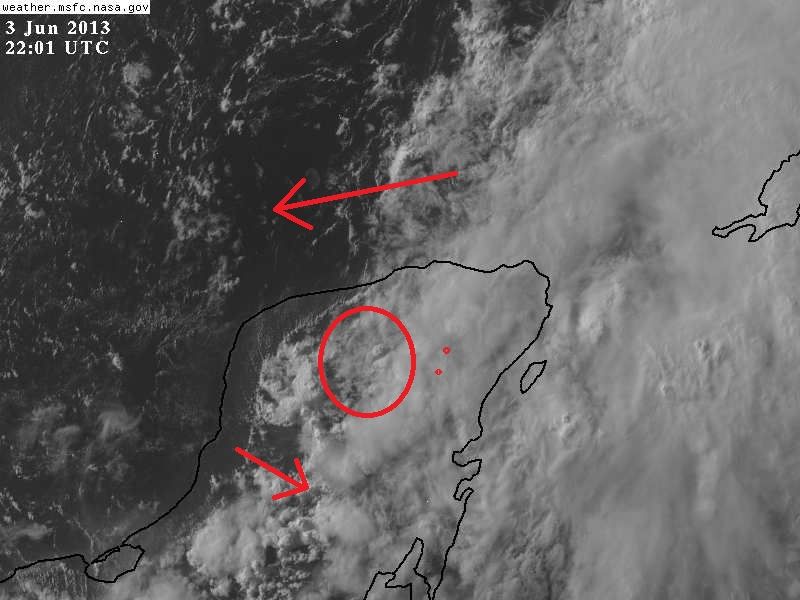
NDG wrote:As if in the last couple of hours a new COC is taking over on the northern section of the Yucatan P, IMO.
the area over land of course cant organize much being over land. There does now appear to be a circ developing offshore at the edge of the convection though probably another vort rotating around a mean center.

0 likes
Note: If I make a post that is brief. Please refer back to previous posts for the analysis or reasoning. I do not re-write/qoute what my initial post said each time.
If there is nothing before... then just ask
Space & Atmospheric Physicist, Embry-Riddle Aeronautical University,
I believe the sky is falling...
If there is nothing before... then just ask
Space & Atmospheric Physicist, Embry-Riddle Aeronautical University,
I believe the sky is falling...
Re: Re:
Aric Dunn wrote:NDG wrote:As if in the last couple of hours a new COC is taking over on the northern section of the Yucatan P, IMO.
http://i20.photobucket.com/albums/b245/ ... 0e6210.jpg
the area over land of course cant organize much being over land. There does now appear to be a circ developing offshore at the edge of the convection though probably another vort rotating around a mean center.
http://imageshack.us/scaled/landing/577/rgb0lalo.jpg
Yes I see the vorticity you pointed out but it appears is rotating around the circulation over the northern Yucatan P.
0 likes
-
Aric Dunn
- Category 5
- Posts: 21238
- Age: 43
- Joined: Sun Sep 19, 2004 9:58 pm
- Location: Ready for the Chase.
- Contact:
you can clearly pick it out now. looks like some convection is about fire in associated with it as the low level cloud deck are thickening,
http://www.ssd.noaa.gov/PS/TROP/floater ... -long.html
http://www.ssd.noaa.gov/PS/TROP/floater ... -long.html
0 likes
Note: If I make a post that is brief. Please refer back to previous posts for the analysis or reasoning. I do not re-write/qoute what my initial post said each time.
If there is nothing before... then just ask
Space & Atmospheric Physicist, Embry-Riddle Aeronautical University,
I believe the sky is falling...
If there is nothing before... then just ask
Space & Atmospheric Physicist, Embry-Riddle Aeronautical University,
I believe the sky is falling...
-
Hurricaneman

- Category 5
- Posts: 7404
- Age: 45
- Joined: Tue Aug 31, 2004 3:24 pm
- Location: central florida
Re: ATL: INVEST 91L
That area 25 to 50 miles north of the Yucatan is where I would watch for continued development
0 likes
-
Hurricane Alexis

- Category 2

- Posts: 683
- Age: 29
- Joined: Thu Jun 14, 2012 7:59 pm
- Location: Miami,Florida
Re: ATL: INVEST 91L
I don't see how this can bring too much rain for SFL. This looks similar to Alberto from '06 which dumped a little bit of rain over here.
0 likes
Personal Forecast Disclaimer:
The posts in this forum are NOT official forecast and should not be used as such. They are just the opinion of the poster and may or may not be backed by sound meteorological data. They are NOT endorsed by any professional institution or storm2k.org. For official information, please refer to the NHC and NWS products.
The posts in this forum are NOT official forecast and should not be used as such. They are just the opinion of the poster and may or may not be backed by sound meteorological data. They are NOT endorsed by any professional institution or storm2k.org. For official information, please refer to the NHC and NWS products.
-
cycloneye
- Admin
- Posts: 149473
- Age: 69
- Joined: Thu Oct 10, 2002 10:54 am
- Location: San Juan, Puerto Rico
Re: ATL: INVEST 91L
Up to 30%
TROPICAL WEATHER OUTLOOK
NWS NATIONAL HURRICANE CENTER MIAMI FL
800 PM EDT MON JUN 3 2013
FOR THE NORTH ATLANTIC...CARIBBEAN SEA AND THE GULF OF MEXICO...
A WEAK LOW PRESSURE AREA LOCATED OVER THE SOUTH-CENTRAL GULF OF
MEXICO CONTINUES TO PRODUCE DISORGANIZED SHOWERS AND THUNDERSTORMS.
SATELLITE IMAGERY AND SURFACE OBSERVATIONS SUGGEST THAT THE
CIRCULATION OF THE LOW HAS BECOME SLIGHTLY BETTER DEFINED TODAY.
ADDITIONAL GRADUAL DEVELOPMENT IS POSSIBLE DURING THE NEXT COUPLE
OF DAYS DESPITE MARGINALLY FAVORABLE ENVIRONMENTAL CONDITIONS. THIS
SYSTEM HAS A MEDIUM CHANCE...30 PERCENT...OF BECOMING A TROPICAL OR
SUBTROPICAL CYCLONE DURING THE NEXT 48 HOURS AS IT DRIFTS GENERALLY
NORTHWARD. REGARDLESS OF DEVELOPMENT...LOCALLY HEAVY RAINS ARE
LIKELY IN ASSOCIATION WITH THE LOW OVER PORTIONS OF THE YUCATAN
PENINSULA...CENTRAL AND WESTERN CUBA...AS WELL AS THE FLORIDA KEYS
AND THE FLORIDA PENINSULA DURING THE NEXT SEVERAL DAYS.
ELSEWHERE...TROPICAL CYCLONE FORMATION IS NOT EXPECTED DURING THE
NEXT 48 HOURS.
$$
FORECASTER KIMBERLAIN
0 likes
Visit the Caribbean-Central America Weather Thread where you can find at first post web cams,radars
and observations from Caribbean basin members Click Here
and observations from Caribbean basin members Click Here
Who is online
Users browsing this forum: No registered users and 72 guests