

Looks like another mini comeback in the works. It sure seems to be moving quickly. Fast moving storms and tropical waves this season.
http://www.ssd.noaa.gov/PS/TROP/floater ... imated.gif
ATL: DORIAN - Post-Tropical - Discussion
Moderator: S2k Moderators
-
amawea

- S2K Supporter

- Posts: 385
- Age: 74
- Joined: Mon Aug 09, 2004 3:36 pm
- Location: Horseshoe Bend, Ar. but from Baytown, Tx
Re: ATL: DORIAN - Remnants - Discussion
StormTracker wrote:I can already see 3 days from now the questions being asked if something develops from the remnants or the area of the remnants: "is this still Dorian", "will it be renamed Dorian", "is this now Erin",etc...To be honest, Dorian didn't sound like a name for a big, bad storm! For some reason Erin does!I have to go back and check the thread of storms that we think are going to be the dangerous ones!
This! He should have been named Dork. If he had of been named Dork, everyone would be saying what a fight that Dork put on.
0 likes
-
Tireman4

- S2K Supporter
- Posts: 5903
- Age: 60
- Joined: Fri Jun 30, 2006 1:08 pm
- Location: Humble, Texas
- Contact:
Re: ATL: DORIAN - Remnants - Discussion
amawea wrote:StormTracker wrote:I can already see 3 days from now the questions being asked if something develops from the remnants or the area of the remnants: "is this still Dorian", "will it be renamed Dorian", "is this now Erin",etc...To be honest, Dorian didn't sound like a name for a big, bad storm! For some reason Erin does!
This! He should have been named Dork. If he had of been named Dork, everyone would be saying what a fight that Dork put on.
Do not forget Don. Don was epic...
0 likes
-
SFLcane

- S2K Supporter
- Posts: 10281
- Age: 48
- Joined: Sat Jun 05, 2010 1:44 pm
- Location: Lake Worth Florida
Re: ATL: DORIAN - Remnants - Discussion
Dorian remnants should be watched in 3-5 days for redevelopment once north of PR near the Bahamas were it could slow to around 10kts near the Gulfstream.
0 likes
-
galaxy401

- Category 5

- Posts: 2446
- Age: 30
- Joined: Sat Aug 25, 2012 9:04 pm
- Location: Casa Grande, Arizona
Redevelopment chances are at 10%. Still not ruling out recon though.
TROPICAL STORM DORIAN WEAKENED THIS AFTERNOON AND THE NATIONAL
HURRICANE CENTER HAS ISSUED THE LAST ADVISORY. THE REMNANTS OF
DORIAN ARE LOCATED ABOUT 375 MILES EAST OF THE NORTHERN LEEWARD
ISLANDS MOVING WESTWARD AT 15 TO 20 MPH. THIS DISTURBANCE IS
EXPECTED TO PASS NORTH OF THE LEEWARD ISLANDS AND PUERTO RICO IN A
DAY OR TWO. ALTHOUGH ENVIRONMENTAL CONDITIONS ARE NOT FAVORABLE FOR
REGENERATION...AN AIR FORCE PLANE IS SCHEDULE TO INVESTIGATE THIS
DISTURBANCE ON SUNDAY...IF NECESSARY. THIS SYSTEM HAS A LOW
CHANCE...10 PERCENT...OF BECOMING A TROPICAL CYCLONE DURING THE
NEXT 48 HOURS.
0 likes
Got my eyes on moving right into Hurricane Alley: Florida.
-
northjaxpro

- S2K Supporter
- Posts: 8900
- Joined: Mon Sep 27, 2010 11:21 am
- Location: Jacksonville, FL
Hmm.. Interesting that they still have Recon still tentatively scheduled to fly out on tomorrow.
0 likes
NEVER, EVER SAY NEVER in the tropics and weather in general, and most importantly, with life itself!!
________________________________________________________________________________________
Fay 2008 Beryl 2012 Debby 2012 Colin 2016 Hermine 2016 Julia 2016 Matthew 2016 Irma 2017 Dorian 2019
________________________________________________________________________________________
Fay 2008 Beryl 2012 Debby 2012 Colin 2016 Hermine 2016 Julia 2016 Matthew 2016 Irma 2017 Dorian 2019
-
Hurricane Alexis

- Category 2

- Posts: 683
- Age: 29
- Joined: Thu Jun 14, 2012 7:59 pm
- Location: Miami,Florida
It doesn't have an LLC so there's no point in recon going. Maybe when the remnants get near the bahamas it will have some chance.
Personal Forecast Disclaimer:
The posts in this forum are NOT official forecast and should not be used as such. They are just the opinion of the poster and may or may not be backed by sound meteorological data. They are NOT endorsed by any professional institution or storm2k.org. For official information, please refer to the NHC and NWS products.
0 likes
Personal Forecast Disclaimer:
The posts in this forum are NOT official forecast and should not be used as such. They are just the opinion of the poster and may or may not be backed by sound meteorological data. They are NOT endorsed by any professional institution or storm2k.org. For official information, please refer to the NHC and NWS products.
The posts in this forum are NOT official forecast and should not be used as such. They are just the opinion of the poster and may or may not be backed by sound meteorological data. They are NOT endorsed by any professional institution or storm2k.org. For official information, please refer to the NHC and NWS products.
-
Gustywind

- Category 5
- Posts: 12334
- Joined: Mon Sep 03, 2007 7:29 am
- Location: Baie-Mahault, GUADELOUPE
8PM discussion.
Excellent news for those who lived in the Leewards, PR as ex TS Dorian is far away from us and should not not pose any trouble
  .
.
THE ONLY COMPROMISE OF THE SURFACE RIDGE IS THE
REMNANTS OF DORIAN LOCATED NEAR 19N54W. HAVING WEAKENED INTO A
TROPICAL WAVE DURING THE PAST 6 HOURS...GALE FORCE WINDS IN THE
NORTHERN SEMICIRCLE PERSIST DUE TO THE STRONG PRESSURE GRADIENT
WITH THE SURFACE RIDGE TO THE NORTH. FURTHER WEAKENING OF THE
REMNANTS IS ANTICIPATED DUE TO THE PREVIOUSLY MENTIONED UPPER
LEVEL LOW WHICH WILL PROVIDE AN INCREASED WIND SHEAR
ENVIRONMENT.
Excellent news for those who lived in the Leewards, PR as ex TS Dorian is far away from us
THE ONLY COMPROMISE OF THE SURFACE RIDGE IS THE
REMNANTS OF DORIAN LOCATED NEAR 19N54W. HAVING WEAKENED INTO A
TROPICAL WAVE DURING THE PAST 6 HOURS...GALE FORCE WINDS IN THE
NORTHERN SEMICIRCLE PERSIST DUE TO THE STRONG PRESSURE GRADIENT
WITH THE SURFACE RIDGE TO THE NORTH. FURTHER WEAKENING OF THE
REMNANTS IS ANTICIPATED DUE TO THE PREVIOUSLY MENTIONED UPPER
LEVEL LOW WHICH WILL PROVIDE AN INCREASED WIND SHEAR
ENVIRONMENT.
0 likes
-
Hurricane Alexis
- Category 2
- Posts: 683
- Age: 29
- Joined: Thu Jun 14, 2012 7:59 pm
- Location: Miami,Florida
Seems as if the trough is moving in tandem with Dorian's remnants.
0 likes
Personal Forecast Disclaimer:
The posts in this forum are NOT official forecast and should not be used as such. They are just the opinion of the poster and may or may not be backed by sound meteorological data. They are NOT endorsed by any professional institution or storm2k.org. For official information, please refer to the NHC and NWS products.
The posts in this forum are NOT official forecast and should not be used as such. They are just the opinion of the poster and may or may not be backed by sound meteorological data. They are NOT endorsed by any professional institution or storm2k.org. For official information, please refer to the NHC and NWS products.
-
ninel conde
Nam revives dorian!!
Joe Bastardi @BigJoeBastardi 12m
NAM 84 hour radar says Dorian still alive pic.twitter.com/6bczOCXr1g
https://twitter.com/BigJoeBastardi/stat ... 20/photo/1
thats the pic.
Joe Bastardi @BigJoeBastardi 12m
NAM 84 hour radar says Dorian still alive pic.twitter.com/6bczOCXr1g
https://twitter.com/BigJoeBastardi/stat ... 20/photo/1
thats the pic.
Last edited by ninel conde on Sat Jul 27, 2013 10:18 pm, edited 1 time in total.
0 likes
-
HURAKAN

- Professional-Met

- Posts: 46084
- Age: 39
- Joined: Thu May 20, 2004 4:34 pm
- Location: Key West, FL
- Contact:
Re: ATL: DORIAN - Remnants - Discussion
JGrin87 wrote:Deep convection bursts occuring right now
Same occurred last night and will probably continue to happen until the wave ever dissipates.
0 likes
-
bamajammer4eva
- Category 4

- Posts: 907
- Joined: Sun Apr 18, 2010 3:21 am
- Location: Ozark, AL

-
Hurricane Alexis
- Category 2
- Posts: 683
- Age: 29
- Joined: Thu Jun 14, 2012 7:59 pm
- Location: Miami,Florida
The NAM is probably depicting what will happen in an alternate world were conditions are favorable.
0 likes
Personal Forecast Disclaimer:
The posts in this forum are NOT official forecast and should not be used as such. They are just the opinion of the poster and may or may not be backed by sound meteorological data. They are NOT endorsed by any professional institution or storm2k.org. For official information, please refer to the NHC and NWS products.
The posts in this forum are NOT official forecast and should not be used as such. They are just the opinion of the poster and may or may not be backed by sound meteorological data. They are NOT endorsed by any professional institution or storm2k.org. For official information, please refer to the NHC and NWS products.

-
Blown Away

- S2K Supporter
- Posts: 10253
- Joined: Wed May 26, 2004 6:17 am
Re: ATL: DORIAN - Remnants - Discussion
0 likes
Hurricane Eye Experience: David 79, Irene 99, Frances 04, Jeanne 04, Wilma 05… Hurricane Brush Experience: Andrew 92, Erin 95, Floyd 99, Matthew 16, Irma 17, Ian 22, Nicole 22…

-
thundercam96

- Tropical Storm

- Posts: 129
- Joined: Thu Aug 18, 2011 3:01 pm
- Location: Boston, MA
Re:
Correct me if I'm wrong, but the NAM models does poorly for tropical systems doesn't it?
Still fun for entertainment though.
0 likes
Fay '08 / Mathew 16'
Personal Forecast Disclaimer: I am not a certified meteorologist, therefore, what is posted on this forum under my header should not be treated as an official forecast. Please refer to the NWS/NHC products for forecast information.
Personal Forecast Disclaimer: I am not a certified meteorologist, therefore, what is posted on this forum under my header should not be treated as an official forecast. Please refer to the NWS/NHC products for forecast information.
-
ozonepete
- Professional-Met
- Posts: 4743
- Joined: Mon Sep 07, 2009 3:23 pm
- Location: From Ozone Park, NYC / Now in Brooklyn, NY
Re: ATL: DORIAN - Remnants - Discussion
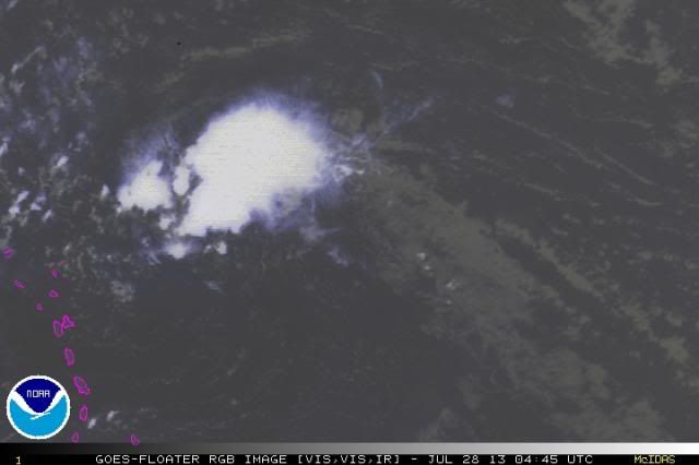
Ha ha I just had to post these images since Dorian is risen from the dead once again. I KNOW that it will get shredded by shear tomorrow but I just thought it was funny how much it came back this evening. Amazingly persistent vorticity. Although I'm sure it will get killed tomorrow, I think it was probably written off a day too early.


0 likes
Who is online
Users browsing this forum: No registered users and 41 guests