ATL: DORIAN - Post-Tropical - Discussion
Moderator: S2k Moderators
-
cycloneye

- Admin

- Posts: 149493
- Age: 69
- Joined: Thu Oct 10, 2002 10:54 am
- Location: San Juan, Puerto Rico
Re: ATL: INVEST 91L - Dorian Remnants - Discussion
I think 91L has slowed a tad in forward motion.
0 likes
Visit the Caribbean-Central America Weather Thread where you can find at first post web cams,radars
and observations from Caribbean basin members Click Here
and observations from Caribbean basin members Click Here
-
Blown Away

- S2K Supporter

- Posts: 10253
- Joined: Wed May 26, 2004 6:17 am
Re: ATL: INVEST 91L - Dorian Remnants - Discussion
What time does the recon go out?
0 likes
Hurricane Eye Experience: David 79, Irene 99, Frances 04, Jeanne 04, Wilma 05… Hurricane Brush Experience: Andrew 92, Erin 95, Floyd 99, Matthew 16, Irma 17, Ian 22, Nicole 22…


Re: ATL: INVEST 91L - Dorian Remnants - Discussion
cycloneye wrote:I think 91L has slowed a tad in forward motion.
I think we are seeing the ULL shear hit it in the front now shearing off the tops...sort of an illusion....JMO....
0 likes
-
HURAKAN

- Professional-Met

- Posts: 46084
- Age: 39
- Joined: Thu May 20, 2004 4:34 pm
- Location: Key West, FL
- Contact:
yet, the airports at Antigua and Barbuda are reporting NE winds
http://weather.noaa.gov/weather/AG_cc.html
http://weather.noaa.gov/weather/AG_cc.html
0 likes

-
Blown Away
- S2K Supporter
- Posts: 10253
- Joined: Wed May 26, 2004 6:17 am
Re:
HURAKAN wrote:yet, the airports at Antigua and Barbuda are reporting NE winds
http://weather.noaa.gov/weather/AG_cc.html
Who's right>? Barbuda weather station clearly reporting W winds??
0 likes
Hurricane Eye Experience: David 79, Irene 99, Frances 04, Jeanne 04, Wilma 05… Hurricane Brush Experience: Andrew 92, Erin 95, Floyd 99, Matthew 16, Irma 17, Ian 22, Nicole 22…
Re:
HURAKAN wrote:yet, the airports at Antigua and Barbuda are reporting NE winds
http://weather.noaa.gov/weather/AG_cc.html
This airport is about 50 miles so south of the island of Barbuda where the westerly winds are being reported.
0 likes
-
Bocadude85

- Category 5

- Posts: 2991
- Age: 39
- Joined: Mon Apr 18, 2005 2:20 pm
- Location: Honolulu,Hi
Re: ATL: INVEST 91L - Dorian Remnants - Discussion
I do not see how this won't be shredded by that ULL
0 likes
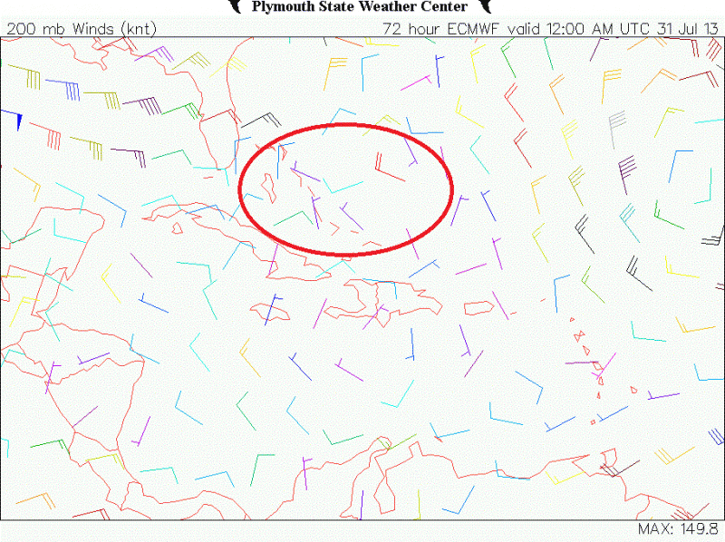
Re: ATL: INVEST 91L - Dorian Remnants - Discussion
Bocadude85 wrote:I do not see how this won't be shredded by that ULL
The Euro is still persistent that the UL trough will weaken or move out of the way over the next 72 hrs or so.
I have circled where 91L should be by Tuesday night, notice the light winds at H200.
0 likes
-
SFLcane

- S2K Supporter
- Posts: 10281
- Age: 48
- Joined: Sat Jun 05, 2010 1:44 pm
- Location: Lake Worth Florida
Re: ATL: INVEST 91L - Dorian Remnants - Discussion
Nothing there per masters...
The remains of Tropical Storm Dorian will be passing just north of northern Lesser Antilles Islands today and just north of Puerto Rico tonight. Satellite images show no signs of a surface circulation, and just a moderate area of heavy thunderstorms associated with the storm. AIr Force hurricane hunter aircraft are on call to investigate Dorian's remains on Sunday afternoon and Monday afternoon, if necessary. In their 8 am EDT Tropical Weather Outlook, NHC gave Dorian's remains a 20% chance of regenerating by Tuesday.
The remains of Tropical Storm Dorian will be passing just north of northern Lesser Antilles Islands today and just north of Puerto Rico tonight. Satellite images show no signs of a surface circulation, and just a moderate area of heavy thunderstorms associated with the storm. AIr Force hurricane hunter aircraft are on call to investigate Dorian's remains on Sunday afternoon and Monday afternoon, if necessary. In their 8 am EDT Tropical Weather Outlook, NHC gave Dorian's remains a 20% chance of regenerating by Tuesday.
0 likes
Re: ATL: INVEST 91L - Dorian Remnants - Discussion
well it most defintely has a MLC back but I really dont see anything at the surface....of course going off Sat view...RECON will solve all of our issues...
clouds tops are warming also so not a good sign this TW has a LLC....
clouds tops are warming also so not a good sign this TW has a LLC....
0 likes
A good hour and a half now that the station in Barbuda has being reporting westerly winds, now switching back to the SSW in the last report.
07 28 11:54 am SSW 4.1 5.1 - - - - 30.01 - 81.9 - - - - -
07 28 11:48 am SSW 4.1 4.1 - - - - 30.01 - 81.7 - - - - -
07 28 11:42 am WSW 4.1 5.1 - - - - 30.01 - 82.0 - - - - -
07 28 11:36 am WSW 4.1 5.1 - - - - 30.01 - 81.9 - - - - -
07 28 11:30 am W 4.1 5.1 - - - - 30.01 - 82.0 - - - - -
07 28 11:24 am W 5.1 6.0 - - - - 30.01 - 81.7 - - - - -
07 28 11:18 am W 6.0 7.0 - - - - 30.01 - 80.6 - - - - -
07 28 11:12 am W 6.0 7.0 - - - - 30.01 - 81.0 - - - - -
07 28 11:06 am W 7.0 8.0 - - - - 30.01 - 79.9 - - - - -
07 28 11:00 am WSW 6.0 7.0 - - - - 30.01 +0.01 80.4 - - - - -
07 28 10:54 am WSW 6.0 8.0 - - - - 30.01 - 79.9 - - - - -
07 28 10:48 am WSW 6.0 8.9 - - - - 30.01 - 79.5 - - - - -
07 28 10:42 am SW 8.0 8.9 - - - - 30.02 - 78.3 - - - - -
07 28 10:36 am WSW 7.0 9.9 - - - - 30.02 - 78.6 - - - - -
07 28 10:30 am SSW 11.1 12.0 - - - - 30.02 - 78.3 - - - - -
07 28 10:24 am SSW 11.1 15.9 - - - - 30.02 - 78.6
0 likes
Re: ATL: INVEST 91L - Dorian Remnants - Discussion
in Barbuda shouldnt the pressure be dropping?..
0 likes
-
Evil Jeremy

- S2K Supporter
- Posts: 5463
- Age: 32
- Joined: Mon Apr 10, 2006 2:10 pm
- Location: Los Angeles, CA
If recon finds a closed circulation (which I find highly unlikely), I don't think the NHC will restart advisories yet. I imagine they would wait until tonight to see if Dorian falls apart as the day progresses. Convection already looks to be weakening:
http://www.ssd.noaa.gov/PS/TROP/floater ... imated.gif
http://www.ssd.noaa.gov/PS/TROP/floater ... imated.gif
0 likes
Frances 04 / Jeanne 04 / Katrina 05 / Wilma 05 / Fay 08 / Debby 12 / Andrea 13 / Colin 16 / Hermine 16 / Matthew 16 / Irma 17
-
Bocadude85
- Category 5
- Posts: 2991
- Age: 39
- Joined: Mon Apr 18, 2005 2:20 pm
- Location: Honolulu,Hi
-
cycloneye
- Admin
- Posts: 149493
- Age: 69
- Joined: Thu Oct 10, 2002 10:54 am
- Location: San Juan, Puerto Rico
Re: ATL: INVEST 91L - Recon
Code: Select all
WEATHER RECONNAISSANCE FLIGHTS
CARCAH, NATIONAL HURRICANE CENTER, MIAMI, FL.
1130 AM EDT SUN 28 JULY 2013
SUBJECT: TROPICAL CYCLONE PLAN OF THE DAY (TCPOD)
         VALID 29/1100Z TO 30/1100Z JULY 2013
         TCPOD NUMBER.....13-058

I.  ATLANTIC REQUIREMENTS
    1. REMNANTS OF TROPICAL STORM DORIAN
       FLIGHT ONE -- TEAL 73
       A. 29/1730Z,2330Z
       B. AFXXX 0304A DORIAN
       C. 29/1600Z
       D. 21.5N 68.0W
       E. 29/1700Z TO 29/2330Z
       F. SFC TO 10,000 FT

       FLIGHT TWO -- TEAL 71
       A. 30/0530Z,1130Z
       B. AFXXX 0404A DORIAN
       C. 30/0330Z
       D. 22.0N 71.0W
       E. 30/0500Z TO 30/1130Z
       F. SFC TO 10,000 FT

    2. OUTLOOK FOR SUCCEEDING DAY:  CONTINUE 6-HRLY FIXES
       WHILE SYSTEM REMAINS A THREAT.
0 likes
Visit the Caribbean-Central America Weather Thread where you can find at first post web cams,radars
and observations from Caribbean basin members Click Here
and observations from Caribbean basin members Click Here
Re: ATL: INVEST 91L - Dorian Remnants - Discussion
ROCK wrote:in Barbuda shouldnt the pressure be dropping?..
Good point, the pressure is only 1 mb lower than 24 hrs but the vorticity/possible LLC is a good 150 miles north of the Island.
0 likes
-
cycloneye
- Admin
- Posts: 149493
- Age: 69
- Joined: Thu Oct 10, 2002 10:54 am
- Location: San Juan, Puerto Rico
Re: ATL: INVEST 91L - Dorian Remnants - Discussion
Sunday's TCPOD is out and this afternoon's mission is going ahead.
viewtopic.php?f=59&t=115297&p=2324659#p2324659
viewtopic.php?f=59&t=115297&p=2324659#p2324659
0 likes
Visit the Caribbean-Central America Weather Thread where you can find at first post web cams,radars
and observations from Caribbean basin members Click Here
and observations from Caribbean basin members Click Here
-
Blown Away
- S2K Supporter
- Posts: 10253
- Joined: Wed May 26, 2004 6:17 am
Re: ATL: INVEST 91L - Dorian Remnants - Discussion

I can see why Barbuda is reporting westerly winds...
0 likes
Hurricane Eye Experience: David 79, Irene 99, Frances 04, Jeanne 04, Wilma 05… Hurricane Brush Experience: Andrew 92, Erin 95, Floyd 99, Matthew 16, Irma 17, Ian 22, Nicole 22…
Who is online
Users browsing this forum: No registered users and 27 guests