ATL: KAREN - Remnants - Discussion

Moderator: S2k Moderators

Message
Author
Aric Dunn
Category 5
Category 5
Posts: 21238
Age: 42
Joined: Sun Sep 19, 2004 9:58 pm
Location: Ready for the Chase.
Contact:

Re: ATL: INVEST 97L - Discussion - 70% / 70%

#441 Postby Aric Dunn » Wed Oct 02, 2013 6:13 pm

Alyono wrote:
Hammy wrote:Will the scheduled overnight flight still occur?


almost certainly it will not. Next recon tomorrow afternoon


unless they canceled the rest going to have noaa soon another AF later..


Code: Select all

1. SUSPECT AREA -- GULF OF MEXICO
       FLIGHT ONE -- TEAL 72        FLIGHT TWO -- NOAA 42
       A. 03/1800Z, 04/0000Z        A. 03/2000Z
       B. AFXXX 0312A CYCLONE       B. NOAA2 0412A CYCLONE
       C. 03/1600Z                  C. 03/1800Z
       D. 23.3N 88.8W               D. 23.4N 88.9W
       E. 03/1730 TO 04/0000Z       E. 03/2000Z TO 05/0000Z     
       F. SFC TO 15,000FT           F. SFC TO 15,000FT

       FLIGHT THREE -- TEAL 73      FLIGHT FOUR --NOAA 43
       A. 04/0600Z, 1200Z           A. 04/0800Z
       B. AFXXX 0512A CYCLONE       B. NOAA3 0612A CYCLONE
       C. 04/0430Z                  C. 04/0600Z
       D. 25.8N 89.3W               D. 25.9N 89.3W
       E. 04/0530Z TO 04/1200Z      E. 04/0730Z TO 04/1130Z
       F. SFC TO 15,000 FT          F. SFC TO 15,000 FT
Last edited by cycloneye on Wed Oct 02, 2013 6:17 pm, edited 1 time in total.
Reason: To add the code to recon information to have it more clear
0 likes   
Note: If I make a post that is brief. Please refer back to previous posts for the analysis or reasoning. I do not re-write/qoute what my initial post said each time.
If there is nothing before... then just ask :)

Space & Atmospheric Physicist, Embry-Riddle Aeronautical University,
I believe the sky is falling...

ozonepete
Professional-Met
Professional-Met
Posts: 4743
Joined: Mon Sep 07, 2009 3:23 pm
Location: From Ozone Park, NYC / Now in Brooklyn, NY

Re: ATL: INVEST 97L - Discussion - 70% / 70%

#442 Postby ozonepete » Wed Oct 02, 2013 6:15 pm

Steve wrote:I hear you Pete but that's not what he said unless I misread the post. I also started it a few frames ago and had to put the iPad down for an hour or so. It actually looks pretty bad ass on the last couple of visibles, even if the look is coming from the middle levels.


No problemo, bud! The "look" of a TC is a little tough to objectify anyway. All I am saying is that for a developing system that isn't even a TD yet it has a really great symmetry, banding, central convective burst and upper outflow all apparent on satellite and I don't recall seeing better for a developing system this year. Even I would have to back that up to prove my point, but I don't have time to post images of the 10 TCs we've had so far in their development stages to prove my point. So we're all good, my friend. :)
0 likes   

User avatar
Texashawk
Category 2
Category 2
Posts: 579
Joined: Tue Aug 14, 2007 1:50 am
Location: Missouri City, TX (Houston)

#443 Postby Texashawk » Wed Oct 02, 2013 6:17 pm

I will say this: it's the most cyclonic open wave I've ever seen...
0 likes   

Aric Dunn
Category 5
Category 5
Posts: 21238
Age: 42
Joined: Sun Sep 19, 2004 9:58 pm
Location: Ready for the Chase.
Contact:

#444 Postby Aric Dunn » Wed Oct 02, 2013 6:20 pm

hehe I thought today was the 3rd lol
0 likes   
Note: If I make a post that is brief. Please refer back to previous posts for the analysis or reasoning. I do not re-write/qoute what my initial post said each time.
If there is nothing before... then just ask :)

Space & Atmospheric Physicist, Embry-Riddle Aeronautical University,
I believe the sky is falling...

SunnyThoughts
Category 5
Category 5
Posts: 2263
Joined: Wed Jul 09, 2003 12:42 pm
Location: Pensacola, Florida

#445 Postby SunnyThoughts » Wed Oct 02, 2013 6:22 pm

So I guess no upgrades until recon tomorrow ( if it organizes by then that is). I guess the only way the NHC would do it tonight would be if they were to get obs from a passing ship or obs from a buoy?
0 likes   

User avatar
TropicalAnalystwx13
Category 5
Category 5
Posts: 2109
Age: 27
Joined: Tue Jul 19, 2011 8:20 pm
Location: Wilmington, NC
Contact:

Re:

#446 Postby TropicalAnalystwx13 » Wed Oct 02, 2013 6:26 pm

SunnyThoughts wrote:So I guess no upgrades until recon tomorrow ( if it organizes by then that is). I guess the only way the NHC would do it tonight would be if they were to get obs from a passing ship or obs from a buoy?

Recon starts another mission at 11pm EDT.
0 likes   

SunnyThoughts
Category 5
Category 5
Posts: 2263
Joined: Wed Jul 09, 2003 12:42 pm
Location: Pensacola, Florida

Re: Re:

#447 Postby SunnyThoughts » Wed Oct 02, 2013 6:28 pm

TropicalAnalystwx13 wrote:
SunnyThoughts wrote:So I guess no upgrades until recon tomorrow ( if it organizes by then that is). I guess the only way the NHC would do it tonight would be if they were to get obs from a passing ship or obs from a buoy?

Recon starts another mission at 11pm EDT.


Ahh ok, I thought the flights listed above were for the 3rd. Didn't look at the times though..
0 likes   

User avatar
summersquall
Tropical Storm
Tropical Storm
Posts: 230
Joined: Wed Jun 16, 2010 11:23 am
Location: Jensen Beach FL 27°N 80°W (roughly)

#448 Postby summersquall » Wed Oct 02, 2013 6:29 pm

ZCZC MIATWOAT ALL
TTAA00 KNHC DDHHMM

TROPICAL WEATHER OUTLOOK
NWS NATIONAL HURRICANE CENTER MIAMI FL
800 PM EDT WED OCT 2 2013

FOR THE NORTH ATLANTIC...CARIBBEAN SEA AND THE GULF OF MEXICO...

THE NATIONAL HURRICANE CENTER IS ISSUING ADVISORIES ON TROPICAL
STORM JERRY...LOCATED OVER THE CENTRAL ATLANTIC.

1. AN AIR FORCE RESERVE UNIT HURRICANE HUNTER AIRCRAFT HAS EXTENSIVELY
INVESTIGATED THE BROAD AREA OF LOW PRESSURE OVER THE NORTHWESTERN
CARIBBEAN SEA...AND DETERMINED THAT THE SYSTEM DID NOT HAVE A
WELL-DEFINED CIRCULATION. HOWEVER...THE LOW IS PRODUCING WINDS TO
GALE FORCE AND HAS THE POTENTIAL TO BECOME A TROPICAL STORM AT ANY
TIME TONIGHT OR ON THURSDAY. THE LOW IS EXPECTED TO MOVE NORTH-
NORTHWESTWARD NEAR OR OVER THE NORTHEASTERN PORTION OF THE YUCATAN
PENINSULA THIS EVENING...AND INTO THE SOUTHERN GULF OF MEXICO BY
EARLY THURSDAY. THIS SYSTEM HAS A HIGH CHANCE...70 PERCENT...OF
BECOMING A TROPICAL CYCLONE DURING THE NEXT 48 HOURS. AFTER
THAT...STRONG UPPER-LEVEL WINDS ARE LIKELY TO LIMIT DEVELOPMENT AS
THE SYSTEM APPROACHES THE NORTHERN GULF OF MEXICO BY THE WEEKEND.
THIS SYSTEM HAS A HIGH CHANCE...70 PERCENT...OF BECOMING A TROPICAL
CYCLONE DURING THE NEXT 5 DAYS. LOCALLY HEAVY RAINS COULD AFFECT
THE CAYMAN ISLANDS...PORTIONS OF CUBA...AND PORTIONS OF THE YUCATAN
PENINSULA DURING THE NEXT DAY OR TWO. INTERESTS IN THE NORTHEASTERN
YUCATAN PENINSULA...WESTERN CUBA...AND THE NORTHERN COAST OF THE
GULF OF MEXICO SHOULD MONITOR THE PROGRESS OF THIS SYSTEM.

FIVE-DAY FORMATION PROBABILITIES ARE EXPERIMENTAL IN 2013. COMMENTS
ON THE EXPERIMENTAL FORECASTS CAN BE PROVIDED AT...

HTTP://WWW.NWS.NOAA.GOV/SURVEY/NWS-SURVEY.PHP?CODE=ETWO

FORECASTER PASCH


Great write-up.
0 likes   

User avatar
SouthernMet
Category 3
Category 3
Posts: 857
Joined: Sun Aug 29, 2010 8:23 pm
Location: fort worth, tx

Re: ATL: INVEST 97L - Discussion - 70% / 70%

#449 Postby SouthernMet » Wed Oct 02, 2013 6:29 pm

Structure looking alot better atm
0 likes   
Nothing that SouthernMet posts, is an official forecast,nor does it reflect views of STORM2K.. SouthernMet is just adding to the great discussions on STORM2K.. Refer to NWS for official forecasts.

User avatar
Steve
S2K Supporter
S2K Supporter
Posts: 9621
Joined: Sat Apr 05, 2003 11:41 pm
Location: Not a state-caster

Re: ATL: INVEST 97L - Discussion - 70% / 70%

#450 Postby Steve » Wed Oct 02, 2013 6:32 pm

Lmao amd agreed. A main point is that the season is far from over. I think we get the K storm out of this which puts us at recent average (11NS) even if still below in ace and number of hurricanes. Lots of bath water in the Caribbean which could take over as principal spawning grounds from the BOC.

For after this front, it again appears that a block will set up and that is being telegraphed by Tropical storm fitow which will crawl Then hook wnw. That should be the pattern after next Tuesday or Wednesday, so the SE US will ne open for a few days if anything else shows up in the Bahamas or Caribbean /back to 97l.

This post is NOT official.
0 likes   

User avatar
northjaxpro
S2K Supporter
S2K Supporter
Posts: 8900
Joined: Mon Sep 27, 2010 11:21 am
Location: Jacksonville, FL

#451 Postby northjaxpro » Wed Oct 02, 2013 6:36 pm

The structure right now looks very good. It is right now among the best looking non classified tropical entities I have evr seen.

I know 2013 hasn' t lived up to billing, but I have to admit that I would be stunned if this isn't Karen by the time the next Recon gets in there tomorrow.
Last edited by northjaxpro on Wed Oct 02, 2013 6:37 pm, edited 1 time in total.
0 likes   
NEVER, EVER SAY NEVER in the tropics and weather in general, and most importantly, with life itself!!

________________________________________________________________________________________

Fay 2008 Beryl 2012 Debby 2012 Colin 2016 Hermine 2016 Julia 2016 Matthew 2016 Irma 2017 Dorian 2019

User avatar
ConvergenceZone
Category 5
Category 5
Posts: 5194
Joined: Fri Jul 29, 2005 1:40 am
Location: Northern California

Re: ATL: INVEST 97L - Discussion - 70% / 70%

#452 Postby ConvergenceZone » Wed Oct 02, 2013 6:37 pm

I noticed the discussion did say, "STRONG UPPER-LEVEL WINDS ARE LIKELY TO LIMIT DEVELOPMENT AS
THE SYSTEM APPROACHES THE NORTHERN GULF OF MEXICO BY THE WEEKEND"

so looks like they aren't expecting to develop much even if it does get named.....Still fun to look at though.
0 likes   

ozonepete
Professional-Met
Professional-Met
Posts: 4743
Joined: Mon Sep 07, 2009 3:23 pm
Location: From Ozone Park, NYC / Now in Brooklyn, NY

Re: ATL: INVEST 97L - Discussion - 70% / 70%

#453 Postby ozonepete » Wed Oct 02, 2013 6:39 pm

What's notable is that all season we were saying how crappy a developing TC looked and many were shocked that it got upgraded. Now most people are saying how great this system looks and are shocked that it's not upgraded. Very funny.

Image

Image
0 likes   

Aric Dunn
Category 5
Category 5
Posts: 21238
Age: 42
Joined: Sun Sep 19, 2004 9:58 pm
Location: Ready for the Chase.
Contact:

#454 Postby Aric Dunn » Wed Oct 02, 2013 6:44 pm

Yeah been the year of organized LLC problems...
0 likes   
Note: If I make a post that is brief. Please refer back to previous posts for the analysis or reasoning. I do not re-write/qoute what my initial post said each time.
If there is nothing before... then just ask :)

Space & Atmospheric Physicist, Embry-Riddle Aeronautical University,
I believe the sky is falling...

psyclone
S2K Supporter
S2K Supporter
Posts: 4762
Joined: Wed Aug 24, 2005 9:04 pm
Location: palm harbor fl

Re: ATL: INVEST 97L - Discussion - 70% / 70%

#455 Postby psyclone » Wed Oct 02, 2013 6:46 pm

ConvergenceZone wrote:I noticed the discussion did say, "STRONG UPPER-LEVEL WINDS ARE LIKELY TO LIMIT DEVELOPMENT AS
THE SYSTEM APPROACHES THE NORTHERN GULF OF MEXICO BY THE WEEKEND"

so looks like they aren't expecting to develop much even if it does get named.....Still fun to look at though.

Recall that Ida (2009) entered the gulf via the Yucatan channel as a 100mph cane and she had little to offer the gulf coast at landfall. we all know how quickly hostile upper level conditions can demolish a storm.
0 likes   

User avatar
MGC
S2K Supporter
S2K Supporter
Posts: 5899
Joined: Sun Mar 23, 2003 9:05 pm
Location: Pass Christian MS, or what is left.

Re: ATL: INVEST 97L - Discussion - 70% / 70%

#456 Postby MGC » Wed Oct 02, 2013 6:51 pm

Ida happend in November. SST are a lot warmer now than in November. Ida was a hurricane just off the mouth of the Mississippi. It did get decouple by stong SW shear. Hurricane Hilda from 1964 would be a better analogy in this case.....MGC
Last edited by MGC on Wed Oct 02, 2013 7:03 pm, edited 1 time in total.
0 likes   

ozonepete
Professional-Met
Professional-Met
Posts: 4743
Joined: Mon Sep 07, 2009 3:23 pm
Location: From Ozone Park, NYC / Now in Brooklyn, NY

Re: ATL: INVEST 97L - Discussion - 70% / 70%

#457 Postby ozonepete » Wed Oct 02, 2013 6:59 pm

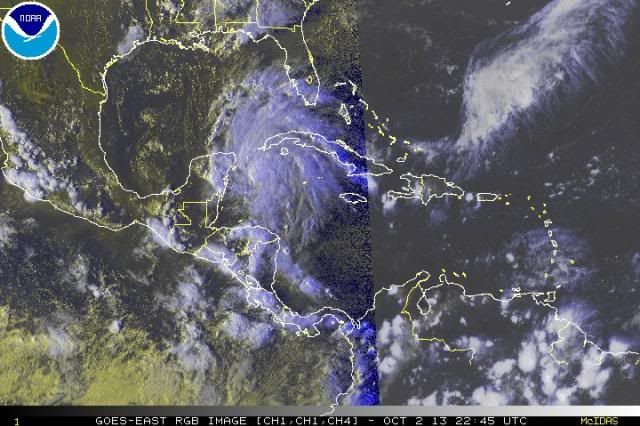
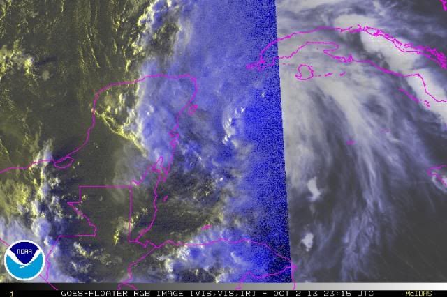
Numerous hot towers popping around the COC. A sure sign of strengthening...

Image
0 likes   

User avatar
deltadog03
Professional-Met
Professional-Met
Posts: 3580
Joined: Tue Jul 05, 2005 6:16 pm
Location: Macon, GA

#458 Postby deltadog03 » Wed Oct 02, 2013 7:09 pm

I would say all systems are a GO. I am super curious to see if the upper anti-cyclone can keep moving with it into the GOM.
0 likes   

psyclone
S2K Supporter
S2K Supporter
Posts: 4762
Joined: Wed Aug 24, 2005 9:04 pm
Location: palm harbor fl

Re: ATL: INVEST 97L - Discussion - 70% / 70%

#459 Postby psyclone » Wed Oct 02, 2013 7:09 pm

MGC wrote:Ida happend in November. SST are a lot warmer now than in November. Ida was a hurricane just off the mouth of the Mississippi. It did get decouple by stong SW shear. Hurricane Hilda from 1964 would be a better analogy in this case.....MGC

ordinarily I would be inclined to agree but this is 2013, the year of the permanent November. My point in brining up Ida is simply to state that it really doesn't matter what the storm looks like upon entering the gulf if it is destined to be eviscerated by shear. of course shear is notoriously unpredictable so vigilance is always prudent. however we've seen plenty of systems struggle over very warm waters this year so the water temp, which is always supportive this time of year, is probably overrated.
0 likes   

Aric Dunn
Category 5
Category 5
Posts: 21238
Age: 42
Joined: Sun Sep 19, 2004 9:58 pm
Location: Ready for the Chase.
Contact:

Re: ATL: INVEST 97L - Discussion - 70% / 70%

#460 Postby Aric Dunn » Wed Oct 02, 2013 7:10 pm

ozonepete wrote:Numerous hot towers popping around the COC. A sure sign of strengthening...

[img]http://i189.photobucket.com/albums/z174/philnyc_2007/satrgb2103-10-022345_zpsde020771.jpg[img]


I think what happened this evening the LLC was trying to consolidate large amounts of convection developed and maintained \.. however the circ was not established enough to overcome the well established seabreeze over the land ares . it was close enough to land that the west winds a apparent circ for the first half the mission disappeared and were replaced by the east winds all of a sudden and recons last pass. This of course created a limited but large enough divergence at the surface on the west side of the circ that it collapsed. I would fully assume over night that the land breezes should help aid the surface circ development along with of course DMAX and what should likely be a large convective burst.
0 likes   
Note: If I make a post that is brief. Please refer back to previous posts for the analysis or reasoning. I do not re-write/qoute what my initial post said each time.
If there is nothing before... then just ask :)

Space & Atmospheric Physicist, Embry-Riddle Aeronautical University,
I believe the sky is falling...


Return to “2013”

Who is online

Users browsing this forum: No registered users and 12 guests