ATL: ANDREA - Post-Tropical
Moderator: S2k Moderators
-
tolakram
- Admin

- Posts: 20186
- Age: 62
- Joined: Sun Aug 27, 2006 8:23 pm
- Location: Florence, KY (name is Mark)
Re: ATL: INVEST 91L
Latest Visible
Live Loop: http://wwwghcc.msfc.nasa.gov/cgi-bin/ge ... umframes=5
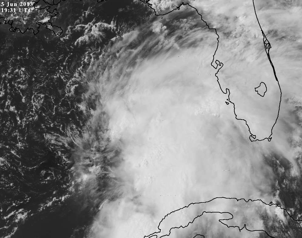
In my amateur opinion the LLC appears to be flying apart. Not very well defined at all.
Live Loop: http://wwwghcc.msfc.nasa.gov/cgi-bin/ge ... umframes=5
In my amateur opinion the LLC appears to be flying apart.
0 likes
M a r k
- - - - -
Join us in chat: Storm2K Chatroom Invite. Android and IOS apps also available.
The posts in this forum are NOT official forecasts and should not be used as such. Posts are NOT endorsed by any professional institution or STORM2K.org. For official information and forecasts, please refer to NHC and NWS products.

-
Aric Dunn
- Category 5

- Posts: 21238
- Age: 43
- Joined: Sun Sep 19, 2004 9:58 pm
- Location: Ready for the Chase.
- Contact:
Re: ATL: INVEST 91L
ozonepete wrote:Another one probably going straight to TS.
lol yeah out in the atlantic is another one..
0 likes
Note: If I make a post that is brief. Please refer back to previous posts for the analysis or reasoning. I do not re-write/qoute what my initial post said each time.
If there is nothing before... then just ask
Space & Atmospheric Physicist, Embry-Riddle Aeronautical University,
I believe the sky is falling...
If there is nothing before... then just ask
Space & Atmospheric Physicist, Embry-Riddle Aeronautical University,
I believe the sky is falling...
-
ozonepete
- Professional-Met

- Posts: 4743
- Joined: Mon Sep 07, 2009 3:23 pm
- Location: From Ozone Park, NYC / Now in Brooklyn, NY
Re: ATL: INVEST 91L
tolakram wrote:Latest Visible
In my amateur opinion the LLC appears to be flying apart.
Mark, I think it really looks like it's consolidating and strengthening...
0 likes

Re:
CrazyC83 wrote:Is it ready to be closed off though? I'm not 100% convinced it is a solid closed circulation yet. But definitely supports a 40 kt intensity.
Yes, it is closed off, they found plenty of west winds near the developing new LLC.
0 likes
-
ozonepete
- Professional-Met
- Posts: 4743
- Joined: Mon Sep 07, 2009 3:23 pm
- Location: From Ozone Park, NYC / Now in Brooklyn, NY
Re: ATL: INVEST 91L
Aric Dunn wrote:ozonepete wrote:Another one probably going straight to TS.
lol yeah out in the atlantic is another one..
Well this is basically what we all expected. But still kind of eerie...
0 likes
Re: ATL: INVEST 91L
tolakram wrote:Latest Visible
Live Loop: http://wwwghcc.msfc.nasa.gov/cgi-bin/ge ... umframes=5
In my amateur opinion the LLC appears to be flying apart.
This is actually the best 91L has looked all of its life, lol.
0 likes
-
Dave

- Retired Staff

- Posts: 13442
- Age: 75
- Joined: Tue Aug 01, 2006 3:57 pm
- Location: Milan Indiana
- Contact:
000
URNT15 KNHC 051954
AF303 01AAA INVEST HDOB 17 20130605
194600 2538N 08543W 9689 00339 0075 +209 +209 126041 042 037 008 00
194630 2539N 08542W 9701 00331 0078 +208 +208 129037 041 034 011 03
194700 2541N 08541W 9701 00331 0078 +206 +206 131040 043 036 012 00
194730 2542N 08540W 9701 00334 0080 +207 +207 131042 043 036 011 00
194800 2544N 08539W 9696 00337 0080 +202 +200 130046 046 035 012 03
194830 2545N 08538W 9704 00328 0082 +200 +200 131043 046 042 022 00
194900 2547N 08538W 9704 00328 0081 +200 +200 135043 044 053 034 00
194930 2548N 08537W 9695 00338 0083 +206 +206 135036 043 052 032 03
195000 2550N 08536W 9712 00323 0083 +213 +213 126034 036 042 021 00
195030 2551N 08535W 9697 00338 0084 +212 +212 126033 035 040 014 00
195100 2552N 08534W 9699 00338 0085 +212 +212 122029 034 033 013 03
195130 2554N 08533W 9710 00326 0085 +207 +207 115024 028 036 015 00
195200 2555N 08532W 9701 00338 0087 +205 +205 110028 029 033 013 00
195230 2557N 08531W 9695 00343 0087 +204 +204 112028 030 033 013 03
195300 2558N 08531W 9707 00333 //// +197 //// 109035 036 036 020 05
195330 2600N 08531W 9699 00340 //// +190 //// 112034 036 /// /// 05
195400 2600N 08533W 9699 00339 0090 +192 //// 108030 032 049 029 01
195430 2600N 08535W 9696 00345 0090 +200 +200 108033 035 047 025 00
195500 2600N 08537W 9701 00340 0091 +204 +204 099031 036 057 039 03
195530 2600N 08539W 9689 00348 0088 +208 +208 115035 039 054 030 00
$$
;
46 kts flt lv; 54 kts sfmr no flag
0 likes
-
Aric Dunn
- Category 5
- Posts: 21238
- Age: 43
- Joined: Sun Sep 19, 2004 9:58 pm
- Location: Ready for the Chase.
- Contact:
unflagged 53kt sfmr...
0 likes
Note: If I make a post that is brief. Please refer back to previous posts for the analysis or reasoning. I do not re-write/qoute what my initial post said each time.
If there is nothing before... then just ask
Space & Atmospheric Physicist, Embry-Riddle Aeronautical University,
I believe the sky is falling...
If there is nothing before... then just ask
Space & Atmospheric Physicist, Embry-Riddle Aeronautical University,
I believe the sky is falling...
-
cycloneye

- Admin
- Posts: 149730
- Age: 69
- Joined: Thu Oct 10, 2002 10:54 am
- Location: San Juan, Puerto Rico
Re: ATL: INVEST 91L
Updated 18z Best Track
More to the east towards new LLC.
AL, 91, 2013060518, , BEST, 0, 253N, 866W, 35, 1006, DB
ftp://ftp.nhc.noaa.gov/atcf/tcweb/inves ... 013.invest
More to the east towards new LLC.
AL, 91, 2013060518, , BEST, 0, 253N, 866W, 35, 1006, DB
ftp://ftp.nhc.noaa.gov/atcf/tcweb/inves ... 013.invest
0 likes
Visit the Caribbean-Central America Weather Thread where you can find at first post web cams,radars
and observations from Caribbean basin members Click Here
and observations from Caribbean basin members Click Here

Wonder if they will wait a few hours to make sure this center remains before they pull the trigger??
0 likes
Ginger-(eye),Dennis,Diana,Kate,Gloria,Charley-(eye),Allison,Arthur,Bertha,Fran,Josephine,Bonnie,Earl,Dennis-(twice),Floyd, Isabel-(eye),Charley,Ophelia-(eyewall),Ernesto,Barry,Hanna,Irene-(eye),Arthur-(eye), Florence, Dorian, and countless depressions, storms, and nor'easters.
-
johngaltfla

- Category 5
- Posts: 2073
- Joined: Sun Jul 10, 2005 9:17 pm
- Location: Sarasota County, FL
- Contact:
Re: ATL: INVEST 91L
cycloneye wrote:Updated 18z Best Track
More to the east towards new LLC.
AL, 91, 2013060518, , BEST, 0, 253N, 866W, 35, 1006, DB
Nertz. There goes the seeding of the yard. Here comes driving to Ft Myers in a monsoon tomororw.

I just wonder if it will have time to make it to TS Andrea to verify my suspicion that this will be a highly active season with numerous TS and subtropical storms this year. The only positive is that it might wake some folks up around the West Coast of FL who haven't been paying attention to the hurricane season since 2006.l
0 likes

-
Evil Jeremy

- S2K Supporter

- Posts: 5463
- Age: 32
- Joined: Mon Apr 10, 2006 2:10 pm
- Location: Los Angeles, CA
Re: ATL: INVEST 91L
How far down the WFL coast should we expect TS warnings and/or watches?
0 likes
Frances 04 / Jeanne 04 / Katrina 05 / Wilma 05 / Fay 08 / Debby 12 / Andrea 13 / Colin 16 / Hermine 16 / Matthew 16 / Irma 17
Who is online
Users browsing this forum: No registered users and 59 guests