EPAC: ALVIN - Post-Tropical
Moderator: S2k Moderators
-
Yellow Evan

- Professional-Met

- Posts: 15952
- Age: 25
- Joined: Fri Jul 15, 2011 12:48 pm
- Location: Henderson, Nevada/Honolulu, HI
- Contact:
-
SouthDadeFish

- Professional-Met
- Posts: 2835
- Joined: Thu Sep 23, 2010 2:54 pm
- Location: Miami, FL
- Contact:

-
supercane4867
- Category 5

- Posts: 4966
- Joined: Wed Nov 14, 2012 10:43 am
Re: EPAC: ALVIN - Tropical Storm
CI# /Pressure/ Vmax
3.0 /1006.0mb/ 45.0kt
Final T# Adj T# Raw T#
3.0 3.3 3.3
Center Temp : -77.0C Cloud Region Temp : -71.6C
Scene Type : UNIFORM CDO CLOUD REGION

3.0 /1006.0mb/ 45.0kt
Final T# Adj T# Raw T#
3.0 3.3 3.3
Center Temp : -77.0C Cloud Region Temp : -71.6C
Scene Type : UNIFORM CDO CLOUD REGION
0 likes
-
dexterlabio
- Category 5
- Posts: 3406
- Joined: Sat Oct 24, 2009 11:50 pm
Re: EPAC: ALVIN - Tropical Storm
Meow wrote:People should focus on Cyclonic Storm Mahasen more. It is killing many people in India and Bangladesh, yet Alvin is harmless forever.
Just let them be. IMO Alvin is worth the attention given that it's the first named EPAC storm of the year, and is possible to become an intense hurricane (maybe a major one)...having said that, people like tracking intense but harmless systems because they find them interesting without worrying about the damages or casualties they may bring.
And I'm pretty sure the world will sympathize to the victims of Mahasen in Bangladesh...
0 likes
Personal Forecast Disclaimer:
The posts in this forum are NOT official forecast and should not be used as such. They are just the opinion of the poster and may or may not be backed by sound meteorological data. They are NOT endorsed by any professional institution or storm2k.org. For official information, please refer to the NHC and NWS products.
The posts in this forum are NOT official forecast and should not be used as such. They are just the opinion of the poster and may or may not be backed by sound meteorological data. They are NOT endorsed by any professional institution or storm2k.org. For official information, please refer to the NHC and NWS products.
-
Hurricaneman

- Category 5
- Posts: 7281
- Age: 43
- Joined: Tue Aug 31, 2004 3:24 pm
- Location: central florida
Re: EPAC: ALVIN - Tropical Storm
Alvin is cool to look at, probably will pop an eye at some point which will make it even better. I prefer these types of systems over landfalling ones like the one in Bangledesh and India
0 likes
-
Yellow Evan
- Professional-Met
- Posts: 15952
- Age: 25
- Joined: Fri Jul 15, 2011 12:48 pm
- Location: Henderson, Nevada/Honolulu, HI
- Contact:

Re: EPAC: ALVIN - Tropical Storm
fast start to a slow overall season after all said is done...
0 likes
Remember, all of my post aren't official. For official warnings and discussions, Please refer to your local NWS products...
NWS for the Western Pacific
https://www.weather.gov/gum/
NWS for the Western Pacific
https://www.weather.gov/gum/

Re:
Yellow Evan wrote:The more I think about this, the more I think Alvin will become a major.
I knew it would become a hurricane before reading the NHC forecast...its just gonna happen unless something strange happens but I think it has a shot at major. The NHC windspeed product has a 3% chance of Alvin becoming a category 4 in 48 hours.
Meow wrote:People should focus on Cyclonic Storm Mahasen more. It is killing many people in India and Bangladesh, yet Alvin is harmless forever.
Its the same reason why we don't focus on 100s dying everyday in Syria from the civil war. Mahasen looks sloppy on satellite but has heavy rains that are doing the damage. That isn't interesting to me personally. Cyclone Nargis in 2008 killed around 150,000 people and got at best, 1/3rd of the pages in a thread that Invest 90L got in the Atlantic back in 2006.
dexterlabio wrote:...having said that, people like tracking intense but harmless systems because they find them interesting without worrying about the damages or casualties they may bring.
Actually the highest activity is in threads where a system is threatening US landmass. This conflicts with what you said.
Yellow Evan wrote:When do you all think Alvin will be a hurricane? I'd say tomorrow is pushing it a little, bu this storm is devloping much faster than expected.
Late tonight. Its inner core is forming extremely fast and the RI index is high enough for me to guess that early. Lock it folks.
euro6208 wrote:fast start to a slow overall season after all said is done...
0 likes
-
dexterlabio
- Category 5
- Posts: 3406
- Joined: Sat Oct 24, 2009 11:50 pm
Re: EPAC: ALVIN - Tropical Storm
^that's expected because people would be asking minute by minute if the hurricane is still going their way, and that is a mark of awareness among the Americans. I assume that no one would find a life-threatening hurricane "likeable"...maybe except for the storm hunters who are interested to film the event, and that can help for damage assessments and met research. IMO.
Btw Alvin is looking really good with that intense convection over the core...
Btw Alvin is looking really good with that intense convection over the core...
0 likes
Personal Forecast Disclaimer:
The posts in this forum are NOT official forecast and should not be used as such. They are just the opinion of the poster and may or may not be backed by sound meteorological data. They are NOT endorsed by any professional institution or storm2k.org. For official information, please refer to the NHC and NWS products.
The posts in this forum are NOT official forecast and should not be used as such. They are just the opinion of the poster and may or may not be backed by sound meteorological data. They are NOT endorsed by any professional institution or storm2k.org. For official information, please refer to the NHC and NWS products.
Ho-hum
Here comes the Killjoy discussion:
There's that magical shear again. I thought this Kelvin wave was suppose to help Alvin out? A 15-knot deduction off the max strength is staggering for one 6 hour cycle, especially when there is nothing hurting the system currently (at least IMO). A different forecaster and a new forecast I guess.
NHC Discussion #4 for TS Alvin wrote:000
WTPZ41 KNHC 160856
TCDEP1
TROPICAL STORM ALVIN DISCUSSION NUMBER 4
NWS NATIONAL HURRICANE CENTER MIAMI FL EP012013
200 AM PDT THU MAY 16 2013
ALVIN CONTINUES TO SLOWLY STRENGTHEN WITH SATELLITE IMAGES SHOWING
VERY DEEP CONVECTION RESEMBLING A CENTRAL DENSE OVERCAST. MICROWAVE
PASSES...HOWEVER...SHOW A LESS ORGANIZED SYSTEM THAN A QUICK GLANCE
WOULD SUGGEST...WITH THE LOW-LEVEL CENTER DISPLACED A FAIR DISTANCE
WEST OF THE STRONGEST BURST. ASCAT AND SATELLITE ESTIMATES SUGGEST
AN INTENSITY OF ABOUT 45 KT...SO THAT WILL BE THE INITIAL WIND
SPEED.
CURRENT WATER VAPOR IMAGES SHOW A LOT OF UPPER-LEVEL WESTERLY WINDS
HEADED TOWARD THE CYCLONE...WITH SOME EVIDENCE OF THE FLOW ALREADY
IMPINGING ON THE CENTER. THE FUTURE STRENGTH OF THE CYCLONE IS
NOT AN EASY FORECAST THIS MORNING WITH CONSIDERABLY MORE SHEAR IN
MOST OF THE MODEL FIELDS THAN YESTERDAY. ALTHOUGH ALL OF THE
GUIDANCE CONTINUE TO SHOW SOME INTENSIFICATION...ONLY THE GFDL
MODEL REALLY SHOWS ALVIN BECOMING ANY MORE THAN A LOW-END CATEGORY
ONE HURRICANE. THE NEW NHC FORECAST IS ABOUT THE SAME AS THE
PREVIOUS ONE FOR THE FIRST 24H...THEN IS REDUCED FOR THE REST OF
THE FORECAST PERIOD TO ACCOUNT FOR THE LATEST MODEL CONSENSUS
GUIDANCE. WEAKENING SHOULD COMMENCE IN ABOUT 3 DAYS DUE TO
INCREASING WESTERLY SHEAR AND GRADUALLY DECREASING SSTS.
A BEVY OF ASCAT AND OTHER MICROWAVE DATA SHOW THAT ALVIN IS
MOVING A BIT SLOWER...290/9. THIS GENERAL MOTION SEEMS PROBABLE
DURING THE NEXT COUPLE OF DAYS WHILE THE CYCLONE REMAINS SOUTH OF A
MID-LEVEL RIDGE OVER MEXICO. AFTER THAT TIME...GLOBAL MODELS ARE
GENERALLY SHOWING LESS OF AN INTERACTION BETWEEN A TROUGH OVER THE
SOUTHWESTERN UNITED STATES AND ALVIN...WHICH RESULTS IN LESS OF A
TURN TO THE NORTHWEST IN THE LONGER RANGE. THE OFFICIAL FORECAST
HAS BEEN SHIFTED TO THE LEFT OF THE PREVIOUS ONE...FOLLOWING THE
TREND OF THE GUIDANCE...BUT IS GENERALLY TO THE RIGHT OF THE MODEL
CONSENSUS AFTER 24H.
FORECAST POSITIONS AND MAX WINDS
INIT 16/0900Z 9.1N 106.9W 45 KT 50 MPH
12H 16/1800Z 9.5N 108.2W 50 KT 60 MPH
24H 17/0600Z 10.2N 109.8W 60 KT 70 MPH
36H 17/1800Z 11.0N 111.5W 65 KT 75 MPH
48H 18/0600Z 11.6N 112.8W 65 KT 75 MPH
72H 19/0600Z 12.8N 115.2W 60 KT 70 MPH
96H 20/0600Z 14.0N 117.0W 40 KT 45 MPH
120H 21/0600Z 14.5N 118.5W 25 KT 30 MPH
$$
FORECASTER BLAKE
There's that magical shear again. I thought this Kelvin wave was suppose to help Alvin out? A 15-knot deduction off the max strength is staggering for one 6 hour cycle, especially when there is nothing hurting the system currently (at least IMO). A different forecaster and a new forecast I guess.
0 likes
-
TropicalAnalystwx13

- Category 5
- Posts: 2109
- Age: 26
- Joined: Tue Jul 19, 2011 8:20 pm
- Location: Wilmington, NC
- Contact:

-
Yellow Evan
- Professional-Met
- Posts: 15952
- Age: 25
- Joined: Fri Jul 15, 2011 12:48 pm
- Location: Henderson, Nevada/Honolulu, HI
- Contact:
Re: Re:
Cyclenall wrote:Yellow Evan wrote:The more I think about this, the more I think Alvin will become a major.
I knew it would become a hurricane before reading the NHC forecast...its just gonna happen unless something strange happens but I think it has a shot at major. The NHC windspeed product has a 3% chance of Alvin becoming a category 4 in 48 hours.Meow wrote:People should focus on Cyclonic Storm Mahasen more. It is killing many people in India and Bangladesh, yet Alvin is harmless forever.
Its the same reason why we don't focus on 100s dying everyday in Syria from the civil war. Mahasen looks sloppy on satellite but has heavy rains that are doing the damage. That isn't interesting to me personally. Cyclone Nargis in 2008 killed around 150,000 people and got at best, 1/3rd of the pages in a thread that Invest 90L got in the Atlantic back in 2006.dexterlabio wrote:...having said that, people like tracking intense but harmless systems because they find them interesting without worrying about the damages or casualties they may bring.
Actually the highest activity is in threads where a system is threatening US landmass. This conflicts with what you said.
Yellow Evan wrote:When do you all think Alvin will be a hurricane? I'd say tomorrow is pushing it a little, bu this storm is devloping much faster than expected.
Late tonight. Its inner core is forming extremely fast and the RI index is high enough for me to guess that early. Lock it folks.
Not looking as good now.euro6208 wrote:fast start to a slow overall season after all said is done...

This is not going to be slow, lol.
Personal Forecast Disclaimer:
The posts in this forum are NOT official forecast and should not be used as such. They are just the opinion of the poster and may or may not be backed by sound meteorological data. They are NOT endorsed by any professional institution or storm2k.org. For official information, please refer to the NHC and NWS products.
0 likes
-
tolakram
- Admin

- Posts: 19165
- Age: 60
- Joined: Sun Aug 27, 2006 8:23 pm
- Location: Florence, KY (name is Mark)
Re: EPAC: ALVIN - Tropical Storm
Hi all,
let's stop the discussion of basins and opinions about who should be watching what please. It's not valuable to this discussion about ALVIN. People will gravitate to what interests them.
Thanks.
let's stop the discussion of basins and opinions about who should be watching what please. It's not valuable to this discussion about ALVIN. People will gravitate to what interests them.
Thanks.
0 likes
M a r k
- - - - -
Join us in chat: Storm2K Chatroom Invite. Android and IOS apps also available.
The posts in this forum are NOT official forecasts and should not be used as such. Posts are NOT endorsed by any professional institution or STORM2K.org. For official information and forecasts, please refer to NHC and NWS products.
-
Yellow Evan
- Professional-Met
- Posts: 15952
- Age: 25
- Joined: Fri Jul 15, 2011 12:48 pm
- Location: Henderson, Nevada/Honolulu, HI
- Contact:
-
supercane4867
- Category 5
- Posts: 4966
- Joined: Wed Nov 14, 2012 10:43 am
Re: EPAC: ALVIN - Tropical Storm
TROPICAL STORM ALVIN DISCUSSION NUMBER 5
NWS NATIONAL HURRICANE CENTER MIAMI FL EP012013
800 AM PDT THU MAY 16 2013
ALVIN APPEARS TO HAVE DEGRADED IN STRUCTURE OVERNIGHT. INFRARED
SATELLITE IMAGERY AND SCATTEROMETER DATA INDICATE THAT THE
CIRCULATION HAS HAD DIFFICULTY SEPARATING FROM THE ITCZ...AND THE
LOW-LEVEL CENTER IS LIKELY LOCATED ON THE WESTERN EDGE OF THE DEEP
CONVECTION. THE INTENSITY IS BEING HELD AT 45 KT BASED ON THE
EARLIER ASCAT DATA...BUT SATELLITE ESTIMATES SUGGEST THAT ALVIN
COULD BE A BIT WEAKER.
ALTHOUGH THE HISTORICALLY TWO BEST GLOBAL MODELS...THE GFS AND
ECMWF...HAVE HAD SOME DISAGREEMENT ON ALVIN...EACH APPEARS TO HAVE
BEEN RIGHT TO SOME DEGREE. THE GFS HAD A BETTER HANDLE ON
GENESIS...BUT THE ECMWF MAY HAVE BEEN RIGHT THAT ALVIN WOULD NOT
STRENGTHEN SIGNIFICANTLY. AS OPPOSED TO YESTERDAY...THE SHIPS
GUIDANCE NOW INDICATES THAT 15 TO 20 KT OF VERTICAL SHEAR WILL
AFFECT ALVIN DURING THE NEXT FIVE DAYS...AND NEITHER OF THE
STATISTICAL MODELS NOW SHOWS THE CYCLONE REACHING HURRICANE
STRENGTH. THE PROSPECTS FOR SIGNIFICANT INTENSIFICATION APPEAR TO
BE DWINDLING...AND THE OFFICIAL FORECAST ESSENTIALLY HOLDS THE
INTENSITY STEADY FOR THE NEXT 48 HOURS. A MORE PRONOUNCED INCREASE
IN WESTERLY SHEAR SHOULD BEGIN A DEFINITE WEAKENING TREND BY DAY
3...AND ALVIN COULD DEGENERATE TO A REMNANT LOW NEAR THE END OF THE
FORECAST PERIOD. NEEDLESS TO SAY...THERE IS STILL LOW CONFIDENCE IN
THE INTENSITY FORECAST.
SINCE THE OFFICIAL INTENSITY FORECAST HAS BEEN LOWERED...THE NHC
TRACK FORECAST HAS BEEN SHIFTED A BIT FARTHER SOUTH AND WEST WITH
THE ASSUMPTION THAT LOWER-LEVEL FLOW WILL HAVE A GREATER INFLUENCE
ON STEERING. THE TRACK MODELS ARE IN BETTER AGREEMENT ON THE
GENERAL DIRECTION TODAY ALTHOUGH THERE IS STILL A SPEED
DISCREPANCY...ESPECIALLY BETWEEN THE GFS AND ECMWF.
FORECAST POSITIONS AND MAX WINDS
INIT 16/1500Z 9.4N 107.7W 45 KT 50 MPH
12H 17/0000Z 9.9N 108.8W 50 KT 60 MPH
24H 17/1200Z 10.7N 110.5W 50 KT 60 MPH
36H 18/0000Z 11.2N 112.3W 50 KT 60 MPH
48H 18/1200Z 11.6N 113.6W 50 KT 60 MPH
72H 19/1200Z 13.0N 116.0W 45 KT 50 MPH
96H 20/1200Z 13.5N 118.5W 30 KT 35 MPH
120H 21/1200Z 13.5N 120.5W 25 KT 30 MPH...POST-TROP/REMNT LOW
$$
FORECASTER BERG
0 likes
-
Yellow Evan
- Professional-Met
- Posts: 15952
- Age: 25
- Joined: Fri Jul 15, 2011 12:48 pm
- Location: Henderson, Nevada/Honolulu, HI
- Contact:
-
tolakram
- Admin
- Posts: 19165
- Age: 60
- Joined: Sun Aug 27, 2006 8:23 pm
- Location: Florence, KY (name is Mark)
Re: EPAC: ALVIN - Tropical Storm
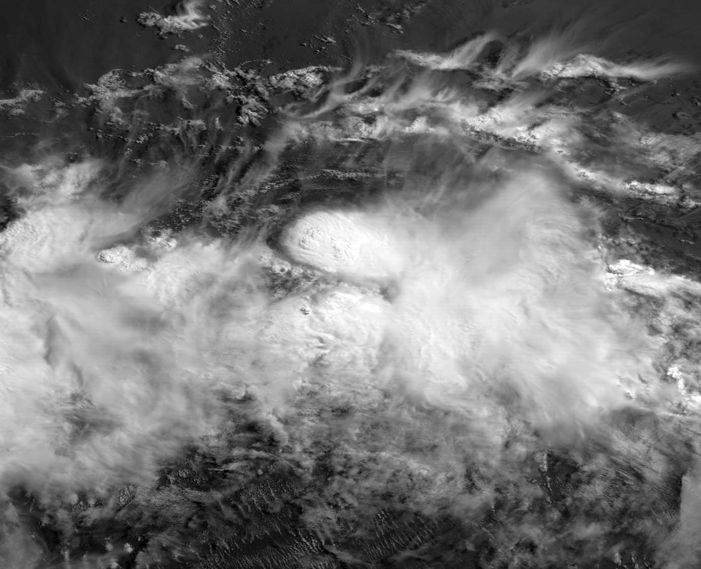
from: ftp://goes.gsfc.nasa.gov/pub/goeswest/overview2/vis/
16:30Z image 1305161630sG15G15I01.tif 75117 KB
lower right hand corner.
16:30Z image 1305161630sG15G15I01.tif 75117 KB
lower right hand corner.
0 likes
M a r k
- - - - -
Join us in chat: Storm2K Chatroom Invite. Android and IOS apps also available.
The posts in this forum are NOT official forecasts and should not be used as such. Posts are NOT endorsed by any professional institution or STORM2K.org. For official information and forecasts, please refer to NHC and NWS products.
- - - - -
Join us in chat: Storm2K Chatroom Invite. Android and IOS apps also available.
The posts in this forum are NOT official forecasts and should not be used as such. Posts are NOT endorsed by any professional institution or STORM2K.org. For official information and forecasts, please refer to NHC and NWS products.
-
Hurricane Jed

- Category 2

- Posts: 542
- Age: 36
- Joined: Mon Jan 24, 2011 3:36 pm
- Location: Cen Tex


Re: EPAC: ALVIN - Tropical Storm
I am really surprised that the NHC still expects it to get to 60 mph looking like it is with the environment not improving much over the next few days.
0 likes
-
TropicalAnalystwx13
- Category 5
- Posts: 2109
- Age: 26
- Joined: Tue Jul 19, 2011 8:20 pm
- Location: Wilmington, NC
- Contact:
Who is online
Users browsing this forum: No registered users and 109 guests