ATL: INVEST 90L
Moderator: S2k Moderators
-
cycloneye

- Admin

- Posts: 139168
- Age: 67
- Joined: Thu Oct 10, 2002 10:54 am
- Location: San Juan, Puerto Rico
Re: ATL: INVEST 90L
We can continue the discussions in this thread until the new invest 91L is up and then we switch to that one.
0 likes
Visit the Caribbean-Central America Weather Thread where you can find at first post web cams,radars
and observations from Caribbean basin members Click Here
and observations from Caribbean basin members Click Here

Re: ATL: INVEST 90L
Well this is interesting they have the graphic in the W.carribean may be a preview for soon to be 91l being located there.

0 likes
The following post is NOT an official forecast and should not be used as such. It is just the opinion of the poster and may or may not be backed by sound meteorological data. It is NOT endorsed by any professional institution including storm2k.org For Official Information please refer to the NHC and NWS products.
-
cycloneye
- Admin
- Posts: 139168
- Age: 67
- Joined: Thu Oct 10, 2002 10:54 am
- Location: San Juan, Puerto Rico
Re: ATL: INVEST 90L
The squadron plans to investigate on Tuesday afternoon.
WEATHER RECONNAISSANCE FLIGHTS
CARCAH, NATIONAL HURRICANE CENTER, MIAMI, FL.
1005 AM EDT SUN 02 JUNE 2013
SUBJECT: TROPICAL CYCLONE PLAN OF THE DAY (TCPOD)
VALID 03/1100Z TO 04/1100Z JUNE 2013
TCPOD NUMBER.....13-002
I. ATLANTIC REQUIREMENTS
1. NEGATIVE RECONNAISSANCE REQUIREMENTS.
2. SUCCEEDING DAY: POSSIBLE LOW LEVEL INVEST
NEAR 23.5N 87.5W AT 04/1800Z.
0 likes
Visit the Caribbean-Central America Weather Thread where you can find at first post web cams,radars
and observations from Caribbean basin members Click Here
and observations from Caribbean basin members Click Here
-
cycloneye
- Admin
- Posts: 139168
- Age: 67
- Joined: Thu Oct 10, 2002 10:54 am
- Location: San Juan, Puerto Rico
Re: ATL: INVEST 90L
AnnularCane wrote:Why is there no floater? And why does it still say "no active storms" up there?
Now we know it was a teaser.
0 likes
Visit the Caribbean-Central America Weather Thread where you can find at first post web cams,radars
and observations from Caribbean basin members Click Here
and observations from Caribbean basin members Click Here
-
Hurricane Andrew

- S2K Supporter

- Posts: 1891
- Age: 25
- Joined: Sun May 23, 2010 2:53 pm
- Location: KS
-
cycloneye
- Admin
- Posts: 139168
- Age: 67
- Joined: Thu Oct 10, 2002 10:54 am
- Location: San Juan, Puerto Rico
Re:
Hurricane Andrew wrote:Any activation yet?
Noy yet but sometime today it will. This thread will be locked and then we go to the new 91L thread to continue the discussions.
0 likes
Visit the Caribbean-Central America Weather Thread where you can find at first post web cams,radars
and observations from Caribbean basin members Click Here
and observations from Caribbean basin members Click Here
-
MiamiensisWx
Re: ATL: INVEST 90L
The new low center looks to form later tonight inland over the Yucatán peninsula near Campeche. A broad trough axis has formed in this area and the upward vertical motion on the east (convergent) side of the axis is intersecting an area of low- and mid-level vorticity that should become more aligned tonight. In the evening, the diurnal maximum should allow convection to develop closer to the vorticity center as the convection over the E Yucatán diminishes due to cool outflow. Low-level convergence will shift over to near Campeche as the trough axis moves through.
http://www.nhc.noaa.gov/tafb_latest/WATL_latest.gif
700-mb vorticity
The dot to the left of the "L" denotes the area where I believe the low is developing:

http://www.nhc.noaa.gov/tafb_latest/WATL_latest.gif
700-mb vorticity
The dot to the left of the "L" denotes the area where I believe the low is developing:
Last edited by MiamiensisWx on Sun Jun 02, 2013 10:44 am, edited 2 times in total.
0 likes
-
cycloneye
- Admin
- Posts: 139168
- Age: 67
- Joined: Thu Oct 10, 2002 10:54 am
- Location: San Juan, Puerto Rico
Re: ATL: INVEST 90L
For those who may want to know where the invests pop up and are deactivated here is the ATCF file for 2013. At the top in the deactivations section you can see 90L deactivated. 91L will pop up below the 90L one if you look down the list.
ftp://ftp.nhc.noaa.gov/atcf/tcweb/
ftp://ftp.nhc.noaa.gov/atcf/tcweb/
0 likes
Visit the Caribbean-Central America Weather Thread where you can find at first post web cams,radars
and observations from Caribbean basin members Click Here
and observations from Caribbean basin members Click Here
-
MiamiensisWx
Re: ATL: INVEST 90L
I'm a little surprised that convection has persisted for nearly nine consecutive hours near Cozumel and has expanded both to the NE and to the SW. These storms are producing rain rates of up to 1.5" inches per hour! Already they are warming the upper troposphere and strengthening the anticyclone at 200 mb; note the emergence of "feathery" outflow on the NW and NE sides according to recent satellite data. None of the models has really captured the strength of the convection which we are seeing now.

0 likes
-
Aric Dunn
- Category 5

- Posts: 21228
- Age: 41
- Joined: Sun Sep 19, 2004 9:58 pm
- Location: Ready for the Chase.
- Contact:
watch for low to start forming just north of fhe yucatan channel today. already a few indications of it.
0 likes
Note: If I make a post that is brief. Please refer back to previous posts for the analysis or reasoning. I do not re-write/qoute what my initial post said each time.
If there is nothing before... then just ask
Space & Atmospheric Physicist, Embry-Riddle Aeronautical University,
I believe the sky is falling...
If there is nothing before... then just ask
Space & Atmospheric Physicist, Embry-Riddle Aeronautical University,
I believe the sky is falling...
-
Hurricane Andrew
- S2K Supporter
- Posts: 1891
- Age: 25
- Joined: Sun May 23, 2010 2:53 pm
- Location: KS
Re: ATL: INVEST 90L
The posts in this forum are NOT official forecast and should not be used as such. They are just the opinion of the poster and may or may not be backed by sound meteorological data. They are NOT endorsed by any professional institution or storm2k.org. For official information, please refer to the NHC and NWS products.
My firstgraphic for this. Red is heaviest conection over last twelve hours. Yellow is where development could begin over the next three days.
Just a simple graphic for now.
Made with SketchBookExpress on my iPad.
EDIT: Unable to get imageshack to work on iPad., can't copy code. Grrr.
http://imageshack.us/content_round.php? ... bSj1Jiq.99
0 likes
The Enthusiast
NREMT-AEMT, WX nerd
Irene '11, Sandy '12, Irma '17 (SAR)
"Hard to think we were born to live this way..." -Wage War
-
floridasun78
- Category 5
- Posts: 3755
- Joined: Sun May 17, 2009 10:16 pm
- Location: miami fl
Re: ATL: INVEST 90L
so south fl going get bad flood what i hearing miami area dade area got alot rain past few weeks not sure if we handle that much rain
0 likes

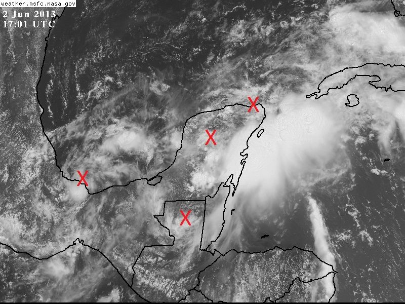
Re: ATL: INVEST 90L
Looking at the HR vis sat loop I can several vorticities where I marked the X on the pix below.
The vorticity in the western BOC is still pretty strong while the vorticity over the interior of the Yucatan P. seems to be getting a surface reflection.
IMO, this might be the reason why 91L has not come out yet because they are trying to wait and see which vorticity becomes the strongest to make sure they start the models right.
0 likes
-
Hurricane Andrew
- S2K Supporter
- Posts: 1891
- Age: 25
- Joined: Sun May 23, 2010 2:53 pm
- Location: KS
-
Hurricane Andrew
- S2K Supporter
- Posts: 1891
- Age: 25
- Joined: Sun May 23, 2010 2:53 pm
- Location: KS
Re:
Aric Dunn wrote:watch for low to start forming just north of fhe yucatan channel today. already a few indications of it.
If you don't mind me asking, what indications? I haven't seen any.
0 likes
The Enthusiast
NREMT-AEMT, WX nerd
Irene '11, Sandy '12, Irma '17 (SAR)
"Hard to think we were born to live this way..." -Wage War
-
Aric Dunn
- Category 5
- Posts: 21228
- Age: 41
- Joined: Sun Sep 19, 2004 9:58 pm
- Location: Ready for the Chase.
- Contact:
Re: Re:
Hurricane Andrew wrote:Aric Dunn wrote:watch for low to start forming just north of fhe yucatan channel today. already a few indications of it.
If you don't mind me asking, what indications? I haven't seen any.
the low level flow has turned more east to west as the ridge builds in. u can alse see a weak rotation taking shape. however there is likely to be multiple vorts develop with every burst of convection.
0 likes
Note: If I make a post that is brief. Please refer back to previous posts for the analysis or reasoning. I do not re-write/qoute what my initial post said each time.
If there is nothing before... then just ask
Space & Atmospheric Physicist, Embry-Riddle Aeronautical University,
I believe the sky is falling...
If there is nothing before... then just ask
Space & Atmospheric Physicist, Embry-Riddle Aeronautical University,
I believe the sky is falling...
-
cycloneye
- Admin
- Posts: 139168
- Age: 67
- Joined: Thu Oct 10, 2002 10:54 am
- Location: San Juan, Puerto Rico
Re: ATL: INVEST 90L
TROPICAL WEATHER OUTLOOK
NWS NATIONAL HURRICANE CENTER MIAMI FL
200 PM EDT SUN JUN 2 2013
FOR THE NORTH ATLANTIC...CARIBBEAN SEA AND THE GULF OF MEXICO...
AN AREA OF DISTURBED WEATHER EXTENDING FROM THE YUCATAN PENINSULA
NORTHEASTWARD TO THE STRAITS OF FLORIDA IS NOT SHOWING ANY SIGNS
OF ORGANIZATION. DEVELOPMENT...IF ANY...OF THIS SYSTEM IS LIKELY
TO BE SLOW TO OCCUR AS IT DRIFTS NORTH-NORTHWESTWARD. THIS SYSTEM
HAS A LOW CHANCE...10 PERCENT...OF BECOMING A TROPICAL CYCLONE
DURING THE NEXT 48 HOURS.
ELSEWHERE...TROPICAL CYCLONE FORMATION IS NOT EXPECTED DURING THE
NEXT 48 HOURS.
$$
FORECASTER BROWN
0 likes
Visit the Caribbean-Central America Weather Thread where you can find at first post web cams,radars
and observations from Caribbean basin members Click Here
and observations from Caribbean basin members Click Here
-
Aric Dunn
- Category 5
- Posts: 21228
- Age: 41
- Joined: Sun Sep 19, 2004 9:58 pm
- Location: Ready for the Chase.
- Contact:
the low itself will likely spin up fast. the shear will be the big inhibitor for the nhc. just north of the ne tip of the yucatan penisula is where its starting develop however i am on my phone sooooo lol
0 likes
Note: If I make a post that is brief. Please refer back to previous posts for the analysis or reasoning. I do not re-write/qoute what my initial post said each time.
If there is nothing before... then just ask
Space & Atmospheric Physicist, Embry-Riddle Aeronautical University,
I believe the sky is falling...
If there is nothing before... then just ask
Space & Atmospheric Physicist, Embry-Riddle Aeronautical University,
I believe the sky is falling...
-
hurricanekid416
- Tropical Storm

- Posts: 179
- Joined: Wed Oct 24, 2012 2:43 pm
Re: ATL: INVEST 90L
If the center ends up being over the Yucatan would it start weakening due to land interactions
0 likes
Personal Forecast Disclaimer:
The posts in this forum are NOT official forecast and should not be used as such. They are just the opinion of the poster and may or may not be backed by sound meteorological data. They are NOT endorsed by any professional institution or storm2k.org. For official information, please refer to the NHC and NWS products.
The posts in this forum are NOT official forecast and should not be used as such. They are just the opinion of the poster and may or may not be backed by sound meteorological data. They are NOT endorsed by any professional institution or storm2k.org. For official information, please refer to the NHC and NWS products.
Re: ATL: INVEST 90L
hurricanekid416 wrote:If the center ends up being over the Yucatan would it start weakening due to land interactions
It would be weak to begin with, not that it will weaken, and will stay weak and broad until it moves over water.
0 likes
Who is online
Users browsing this forum: No registered users and 56 guests