ATL: INVEST 92L
Moderator: S2k Moderators


-
cycloneye

- Admin

- Posts: 139120
- Age: 67
- Joined: Thu Oct 10, 2002 10:54 am
- Location: San Juan, Puerto Rico
Re: ATL: INVEST 92L
Look where the naked LLC of ex92L is located on this Sunday afternoon. 

0 likes
Visit the Caribbean-Central America Weather Thread where you can find at first post web cams,radars
and observations from Caribbean basin members Click Here
and observations from Caribbean basin members Click Here

-
Syx6sic
- Tropical Depression

- Posts: 84
- Age: 39
- Joined: Wed Jun 05, 2013 12:11 pm
- Location: Virginia beach VA
Looks nice but the real question is will it keep trying to come back and if it does where do u see it going. I am new here but lived on east coast thru every hurricane that's went they va in Norfolk since 84 glad to find a board that loves these storms just as much as me sorry got alittle off topic there but does look like ex92L is trying to make a comeback
0 likes
Personal Forecast Disclaimer:
The posts in this forum are NOT official forecast and should not be used as such. They are just the opinion of the poster and may or may not be backed by sound meteorological data. They are NOT endorsed by any professional institution or storm2k.org. For official information, please refer to the NHC and NWS products.
The posts in this forum are NOT official forecast and should not be used as such. They are just the opinion of the poster and may or may not be backed by sound meteorological data. They are NOT endorsed by any professional institution or storm2k.org. For official information, please refer to the NHC and NWS products.
-
ozonepete
- Professional-Met

- Posts: 4743
- Joined: Mon Sep 07, 2009 3:23 pm
- Location: From Ozone Park, NYC / Now in Brooklyn, NY
Re: ATL: Ex INVEST 92L
Welcome to storm2k! Right now this is really not much more than a curiosity. It's just a very small surface swirl that I can't see developing into anything significant because of its size. We just enjoy watching any activity in the tropics.
0 likes
-
Syx6sic
- Tropical Depression
- Posts: 84
- Age: 39
- Joined: Wed Jun 05, 2013 12:11 pm
- Location: Virginia beach VA
Yea looks interesting and to survive all that shear even though all the convection left and then it's getting it back does remind me of Katrina though
0 likes
Personal Forecast Disclaimer:
The posts in this forum are NOT official forecast and should not be used as such. They are just the opinion of the poster and may or may not be backed by sound meteorological data. They are NOT endorsed by any professional institution or storm2k.org. For official information, please refer to the NHC and NWS products.
The posts in this forum are NOT official forecast and should not be used as such. They are just the opinion of the poster and may or may not be backed by sound meteorological data. They are NOT endorsed by any professional institution or storm2k.org. For official information, please refer to the NHC and NWS products.
-
ozonepete
- Professional-Met
- Posts: 4743
- Joined: Mon Sep 07, 2009 3:23 pm
- Location: From Ozone Park, NYC / Now in Brooklyn, NY
Re: ATL: Ex INVEST 92L
Well now, Katrina I don't see at all. And although there is vorticity from 850mb all the way up to 500mb on the CIMSS charts, and you can see a larger swirl associated with this wave on the satellite loops still moving westward, I don't see anything happening with this anymore. If something did happen it wouldn't even be 92L anyway.
0 likes


-
cycloneye
- Admin
- Posts: 139120
- Age: 67
- Joined: Thu Oct 10, 2002 10:54 am
- Location: San Juan, Puerto Rico
Re:
Nimbus wrote:Probably very shallow broad low pressure at the surface, just the swirl moving west that is easy to track. Have all the models dropped this feature?
None show anything with it.
0 likes
Visit the Caribbean-Central America Weather Thread where you can find at first post web cams,radars
and observations from Caribbean basin members Click Here
and observations from Caribbean basin members Click Here
-
ozonepete
- Professional-Met
- Posts: 4743
- Joined: Mon Sep 07, 2009 3:23 pm
- Location: From Ozone Park, NYC / Now in Brooklyn, NY
Re: ATL: Ex INVEST 92L
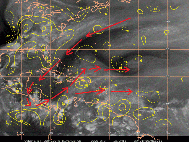
Yeah, Luis, it's been dropped for a while now. I put on my thinking cap and went digging, and I think I found the answer. This has moved under a TUTT (Tropical Upper Tropospheric Trough) and there is no upper divergence at all under such a feature. I attached the CIMSS upper divergence chart with the TUTT annotated and you can see the large area of negative divergence within the upper trough (at 200-300mb) and thus overhead of this wave. So there is no large scale evacuation of air over the top of the wave and thus it can't produce convection. While it still could regenerate after it gets into the Gulf and past this feature, it's hardly that likely anymore. I've just been following it because it's the only game in town.

0 likes
-
Syx6sic
- Tropical Depression
- Posts: 84
- Age: 39
- Joined: Wed Jun 05, 2013 12:11 pm
- Location: Virginia beach VA
Yea seems like the only thing to watch right now
0 likes
Personal Forecast Disclaimer:
The posts in this forum are NOT official forecast and should not be used as such. They are just the opinion of the poster and may or may not be backed by sound meteorological data. They are NOT endorsed by any professional institution or storm2k.org. For official information, please refer to the NHC and NWS products.
The posts in this forum are NOT official forecast and should not be used as such. They are just the opinion of the poster and may or may not be backed by sound meteorological data. They are NOT endorsed by any professional institution or storm2k.org. For official information, please refer to the NHC and NWS products.
Who is online
Users browsing this forum: No registered users and 21 guests