WPAC: SOULIK- Post-Tropical

Moderator: S2k Moderators

Message
Author
User avatar
alan1961
Category 2
Category 2
Posts: 767
Joined: Mon Mar 20, 2006 11:58 am
Location: Derby, Derbyshire, England
Contact:

Re:

#121 Postby alan1961 » Wed Jul 10, 2013 4:59 pm

dexterlabio wrote:Looks like GFS is going for Taiwan landfall. The 12z run reminds me a lot of Haitang. Speaking of GFS, it's also starting to show a new system early next week...more ensemble members are showing this.


Image

18Z still going for Taiwan landfall and bulls eye for Taipei in 48 hours.
0 likes   

User avatar
euro6208
Category 5
Category 5
Posts: 18547
Joined: Mon Mar 08, 2004 7:50 pm
Location: Guam

Re: WPAC: SOULIK- Typhoon

#122 Postby euro6208 » Thu Jul 11, 2013 12:09 am

Image

intense...
0 likes   
Remember, all of my post aren't official. For official warnings and discussions, Please refer to your local NWS products...

NWS for the Western Pacific

https://www.weather.gov/gum/

User avatar
euro6208
Category 5
Category 5
Posts: 18547
Joined: Mon Mar 08, 2004 7:50 pm
Location: Guam

Re: WPAC: SOULIK- Typhoon

#123 Postby euro6208 » Thu Jul 11, 2013 12:34 am

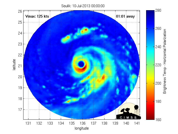
Category 3 Soulik is headed right towards an area of higher OHC so strengthening seems likely...

Image


WDPN31 PGTW 110300
MSGID/GENADMIN/JOINT TYPHOON WRNCEN PEARL HARBOR HI//
SUBJ/PROGNOSTIC REASONING FOR TYPHOON 07W (SOULIK) WARNING NR 14//
RMKS//
1. FOR METEOROLOGISTS.
2. 6 HOUR SUMMARY AND ANALYSIS.
TYPHOON (TY) 07W (SOULIK), LOCATED APPROXIMATELY 317 NM
SOUTHEASTWARD OF KADENA AB, HAS TRACKED WESTWARD AT 11 KNOTS OVER
THE PAST SIX HOURS. ANIMATED MULTISPECTRAL SATELLITE IMAGERY (MSI)
REVEALS A WELL-DEFINED SYSTEM WITH MULTIPLE BANDING FEATURES
WRAPPING AROUND A RECENTLY REFORMED, RAGGED 25 NM EYE. INFRARED (IR)
IMAGERY ADDITIONALLY SHOWS CONVECTION HAS WARMED AND SHALLOWED,
WHICH IS INDICATIVE OF THE CURRENT WEAKENING TREND WHILE THIS SYSTEM
TRACKS OVER A COLD EDDY, WITH LOWERED OCEAN HEAT CONTENT (OHC)
VALUES. THERE IS HIGH CONFIDENCE IN THE CURRENT POSITION BASED ON
THE RAGGED EYE FEATURE IN THE MSI AND IR IMAGERY. THE INITIAL
INTENSITY HAS BEEN LOWERED TO 105 KNOTS BASED ON CONCURRENT DVORAK
CURRENT INTENSITY ESTIMATES OF 102 KNOTS FROM ALL AGENCIES. UPPER-
LEVEL ANALYSIS REVEALS TY 07W CONTINUES TO EXHIBIT RADIAL OUTFLOW
WITH LOW (05-10 KNOTS) VERTICAL WIND SHEAR (VWS) RESULTING IN AN
OVERALL FAVORABLE ENVIRONMENT. TY 07W IS STEADILY TRACKING WESTWARD
ALONG THE SOUTHERN PERIPHERY OF A DEEP-LAYERED EAST-WEST ORIENTED
SUBTROPICAL RIDGE ANCHORED NORTH OF THE SYSTEM.
3. FORECAST REASONING.
A. THERE IS NO SIGNIFICANT CHANGE TO THE FORECAST PHILOSOPHY
SINCE THE PREVIOUS PROGNOSTIC REASONING MESSAGE.
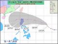
B. UNDER THE STEERING INFLUENCE OF THE DEEP STR, TY 07W WILL
CONTINUE TO TRACK WESTWARD TO WEST-NORTHWESTWARD THROUGH TAU 36.
JUST PRIOR TO TAU 48, TY 07W IS EXPECTED TO MAKE LANDFALL ACROSS
NORTHERN TAIWAN AND BEGIN TRACKING MORE NORTHWESTERLY ACROSS THE
TAIWAN STRAIT AND INTO EASTERN CHINA. TY 07W IS EXPECTED TO SLIGHTLY
INTENSIFY IN THE NEXT 24 HOURS AS IT MOVES AWAY FROM THE COOLER OHC
VALUES AND TRACKS OVER THE WARM KUROSHIO CURRENT. AFTER TAU 24,
WEAKENING IS EXPECTED AS A COMBINATION OF INCREASING VWS VALUES AND
LAND INTERACTION BEGIN TO DEGRADE THE SYSTEM. DYNAMIC MODEL GUIDANCE
REMAINS IN TIGHT AGREEMENT, WITH ONLY A 150NM SPREAD THROUGH TAU 72.
C. IN THE EXTENDED PERIOD, TY 07W WILL BE WELL INLAND BY TAU 72
AND THEN RE-CURVE NORTHWARD ALONG THE WESTERN PERIPHERY OF THE STR.
RAPID WEAKENING IS EXPECTED DUE TO THE FRICTIONAL EFFECTS OF LAND
AND INCREASED VWS WHICH WILL LEAD TO DISSIPATION BY TAU 96. THE
DYNAMIC GUIDANCE IS SLIGHTLY SPREAD IN THE EXTENDED TAUS, BUT NOW
ALL GUIDANCE, ALONG WITH ENSEMBLE DATA, SUPPORTS A NORTHERN TRACK
OVER LAND. THERE IS HIGH CONFIDENCE IN THE JTWC FORECAST TRACK BASED
ON THE GOOD AGREEMENT OF THE MODELS AND THE WELL DEFINED STEERING
ENVIRONMENT.//
NNNN


Image

very warm core at 12,000 ft
0 likes   
Remember, all of my post aren't official. For official warnings and discussions, Please refer to your local NWS products...

NWS for the Western Pacific

https://www.weather.gov/gum/

RobWESTPACWX
WestPACMet
WestPACMet
Posts: 1616
Joined: Fri Sep 17, 2010 2:26 am
Location: Tokyo, Japan
Contact:

Re: WPAC: SOULIK- Typhoon

#124 Postby RobWESTPACWX » Thu Jul 11, 2013 2:29 am

I find it funny that even though Chantal is dead its still getting far more hits on here than Soulik. A well. Must just be my perspective.

Image below is off my co-workers downstairs talking about Soulik.

Image

Plus MMIC going though EWRC

Image
0 likes   
Satellites, Charts and Forecasting tools for East Asia at WESTERNPACIFICWEATHER.COM

RobWESTPACWX
WestPACMet
WestPACMet
Posts: 1616
Joined: Fri Sep 17, 2010 2:26 am
Location: Tokyo, Japan
Contact:

Re: WPAC: SOULIK- Typhoon

#125 Postby RobWESTPACWX » Thu Jul 11, 2013 3:15 am

Starting to look a little more organized right now. It fought off that dry air inflow.

Image
0 likes   
Satellites, Charts and Forecasting tools for East Asia at WESTERNPACIFICWEATHER.COM

User avatar
jaguarjace
Category 4
Category 4
Posts: 975
Age: 29
Joined: Sat Jun 11, 2011 7:38 am
Location: Khon Kaen, Thailand

Re: WPAC: SOULIK- Typhoon

#126 Postby jaguarjace » Thu Jul 11, 2013 4:02 am

Latest satellite image
Image

JUL 10 1732 UTC - JUL 11 0732 UTC Floater Loops:
>WATER VAPOR Enhancement
>RGB Enhancement
>RAINBOW Enhancement
>RBTOP Enhancement
0 likes   
Owner of the Tropical Archive YouTube channel
Web Developer at Force Thirteen
Twitter/X : @force13_support

Typhoon Hunter
WesternPacificWeather.com
Posts: 1215
Age: 40
Joined: Wed Oct 11, 2006 11:37 am
Location: Hong Kong
Contact:

Re: WPAC: SOULIK- Typhoon

#127 Postby Typhoon Hunter » Thu Jul 11, 2013 4:35 am

Hi guys.

I made it to NE Taiwan in one piece. If current forecasts and track holds we should be expecting landfall in around 36hrs time. Soulik certainly looks more impressive than it did this morning. More favorable environment ahead it would seem!
0 likes   
James - Documenting typhoons...

http://www.youtube.com/TyphoonHunter

RobWESTPACWX
WestPACMet
WestPACMet
Posts: 1616
Joined: Fri Sep 17, 2010 2:26 am
Location: Tokyo, Japan
Contact:

#128 Postby RobWESTPACWX » Thu Jul 11, 2013 5:36 am

Winds up to 40kph in Naha right now, pressure starting to drop in Miyako-Jima as well. Shes coming.
0 likes   
Satellites, Charts and Forecasting tools for East Asia at WESTERNPACIFICWEATHER.COM

User avatar
mrbagyo
Category 5
Category 5
Posts: 3614
Age: 31
Joined: Thu Apr 12, 2012 9:18 am
Location: 14.13N 120.98E
Contact:

Re: WPAC: SOULIK- Typhoon

#129 Postby mrbagyo » Thu Jul 11, 2013 6:04 am

0MG. the eye is HUGE!!!

Image
0 likes   
The posts in this forum are NOT official forecast and should not be used as such. They are just the opinion of the poster and may or may not be backed by sound meteorological data. They are NOT endorsed by any professional institution or storm2k.org. For official information, please refer to RSMC, NHC and NWS products.

User avatar
Filipinas50
Tropical Depression
Tropical Depression
Posts: 77
Age: 59
Joined: Tue May 28, 2013 2:07 am
Location: Planet Earth

Re: WPAC: SOULIK- Typhoon

#130 Postby Filipinas50 » Thu Jul 11, 2013 6:55 am

Image
0 likes   
RETIRED FROM THE 9-5 RAT RACE

User avatar
euro6208
Category 5
Category 5
Posts: 18547
Joined: Mon Mar 08, 2004 7:50 pm
Location: Guam

Re: WPAC: SOULIK- Typhoon

#131 Postby euro6208 » Thu Jul 11, 2013 8:31 am

Typhoon Hunter wrote:Hi guys.

I made it to NE Taiwan in one piece. If current forecasts and track holds we should be expecting landfall in around 36hrs time. Soulik certainly looks more impressive than it did this morning. More favorable environment ahead it would seem!


I would love to be in your shoes. Stay safe and always check in when you can.
0 likes   
Remember, all of my post aren't official. For official warnings and discussions, Please refer to your local NWS products...

NWS for the Western Pacific

https://www.weather.gov/gum/

User avatar
euro6208
Category 5
Category 5
Posts: 18547
Joined: Mon Mar 08, 2004 7:50 pm
Location: Guam

Re: WPAC: SOULIK- Typhoon

#132 Postby euro6208 » Thu Jul 11, 2013 8:36 am

Image

:double:
0 likes   
Remember, all of my post aren't official. For official warnings and discussions, Please refer to your local NWS products...

NWS for the Western Pacific

https://www.weather.gov/gum/

User avatar
Amoygal
Tropical Low
Tropical Low
Posts: 16
Joined: Sun May 29, 2011 8:46 pm
Location: Taiwan

#133 Postby Amoygal » Thu Jul 11, 2013 9:03 am

I'm away from Taipei right now (heading back next Wednesday), and I have to say, I'm a little disappointed to be missing this. Hoping for minimal damage and no loss of life.
0 likes   

dexterlabio
Category 5
Category 5
Posts: 3407
Joined: Sat Oct 24, 2009 11:50 pm

Re: WPAC: SOULIK- Typhoon

#134 Postby dexterlabio » Thu Jul 11, 2013 9:17 am

Wow that is one huge eye. If thats gonna hit Taiwan then all of it will feel the eyewall intensity. I wonder if that apparently larger eyewall will strengthen further...it seems there is still some dry air issues..
0 likes   
Personal Forecast Disclaimer:
The posts in this forum are NOT official forecast and should not be used as such. They are just the opinion of the poster and may or may not be backed by sound meteorological data. They are NOT endorsed by any professional institution or storm2k.org. For official information, please refer to the NHC and NWS products.

User avatar
gatorcane
S2K Supporter
S2K Supporter
Posts: 23499
Age: 46
Joined: Sun Mar 13, 2005 3:54 pm
Location: Boca Raton, FL

Re: WPAC: SOULIK- Typhoon

#135 Postby gatorcane » Thu Jul 11, 2013 1:43 pm

RobWESTPACWX wrote:I find it funny that even though Chantal is dead its still getting far more hits on here than Soulik. A well. Must just be my perspective.

Image below is off my co-workers downstairs talking about Soulik.

Plus MMIC going though EWRC


My guess is that there are far more united states storm2kers following Atlantic systems which could pose a threat whereas epac and Asia systems dont get interest because they won't impact folks in the states.

That said impressive typhoon with a large eye!
0 likes   

User avatar
gatorcane
S2K Supporter
S2K Supporter
Posts: 23499
Age: 46
Joined: Sun Mar 13, 2005 3:54 pm
Location: Boca Raton, FL

#136 Postby gatorcane » Thu Jul 11, 2013 2:03 pm

0 likes   

User avatar
'CaneFreak
Category 5
Category 5
Posts: 1475
Joined: Mon Jun 05, 2006 10:50 am
Location: New Bern, NC

#137 Postby 'CaneFreak » Thu Jul 11, 2013 2:07 pm

The company I currently work for has client interests in Taipei so we are following this one very closely. Looks like in the last hour or two Soulik has hit that high OHC water and has built up some convection in the CDO again. In addition, it may be undergoing another eyewall replacement cycle now as we speak. Interesting indeed. I hope everyone there stays safe. They are expecting 10 to 15 inches of rain.
Last edited by 'CaneFreak on Thu Jul 11, 2013 2:10 pm, edited 1 time in total.
0 likes   

User avatar
northjaxpro
S2K Supporter
S2K Supporter
Posts: 8900
Joined: Mon Sep 27, 2010 11:21 am
Location: Jacksonville, FL

#138 Postby northjaxpro » Thu Jul 11, 2013 2:10 pm

I have been so awestruck by this textbook tropical cyclone. It is simply awesome to be tracking this monster. My prayers to all who are in the path of this dangerous tropical cyclone!
0 likes   
NEVER, EVER SAY NEVER in the tropics and weather in general, and most importantly, with life itself!!

________________________________________________________________________________________

Fay 2008 Beryl 2012 Debby 2012 Colin 2016 Hermine 2016 Julia 2016 Matthew 2016 Irma 2017 Dorian 2019

User avatar
jaguarjace
Category 4
Category 4
Posts: 975
Age: 29
Joined: Sat Jun 11, 2011 7:38 am
Location: Khon Kaen, Thailand

Re: WPAC: SOULIK- Typhoon

#139 Postby jaguarjace » Thu Jul 11, 2013 2:17 pm

Strong bursts of convection continues to wrap around Soulik.
Image

JUL 11 0332 UTC - JUL 11 1732 UTC Floater Loops:
>WATER VAPOR Enhancement
>RGB Enhancement
>RAINBOW Enhancement
>RBTOP Enhancement
0 likes   
Owner of the Tropical Archive YouTube channel
Web Developer at Force Thirteen
Twitter/X : @force13_support

User avatar
Hurricane_Luis
Category 2
Category 2
Posts: 723
Age: 26
Joined: Sat Jun 23, 2012 3:14 pm
Location: Tiptree, Essex, United Kingdom
Contact:

#140 Postby Hurricane_Luis » Thu Jul 11, 2013 2:52 pm

Category 3 Typhoon Soulik.

Image
0 likes   


Return to “2013”

Who is online

Users browsing this forum: No registered users and 51 guests