CPAC: FLOSSIE - Post-Tropical

Moderator: S2k Moderators

Message
Author
User avatar
Yellow Evan
Professional-Met
Professional-Met
Posts: 15954
Age: 25
Joined: Fri Jul 15, 2011 12:48 pm
Location: Henderson, Nevada/Honolulu, HI
Contact:

Re: Re:

#361 Postby Yellow Evan » Mon Jul 29, 2013 5:42 pm

WeatherGuesser wrote:
Yellow Evan wrote:"First direct hit in 20 years" is plain truth, nothing really inaccurate by it

True, if it remains a TS. If it drops to TD, does it qualify as a 'direct hit'? That was one of the big questions last year in NJ and NY. Did they get hit by a hurricane or not? We all know how devastating it was, whatever they got, but it really isn't in the books as a hurricane strike.


A TD is a big storm for sure, but will it be in the books as a direct strike or will they go longer than 20 years?


Of course. A TD is a tropical cyclone after all.
0 likes   

User avatar
Yellow Evan
Professional-Met
Professional-Met
Posts: 15954
Age: 25
Joined: Fri Jul 15, 2011 12:48 pm
Location: Henderson, Nevada/Honolulu, HI
Contact:

#362 Postby Yellow Evan » Mon Jul 29, 2013 6:58 pm

http://www.islandsir.com/webcam/

Webcam almost near the LLC.
0 likes   

User avatar
Yellow Evan
Professional-Met
Professional-Met
Posts: 15954
Age: 25
Joined: Fri Jul 15, 2011 12:48 pm
Location: Henderson, Nevada/Honolulu, HI
Contact:

#363 Postby Yellow Evan » Mon Jul 29, 2013 7:23 pm

WTPA31 PHFO 292358
TCPCP1

BULLETIN
TROPICAL STORM FLOSSIE INTERMEDIATE ADVISORY NUMBER 20A
NWS CENTRAL PACIFIC HURRICANE CENTER HONOLULU HI EP062013
200 PM HST MON JUL 29 2013

...FLOSSIE WEAKENING NEAR MAUI...


SUMMARY OF 200 PM HST...0000 UTC...INFORMATION
----------------------------------------------
LOCATION...21.0N 155.5W
ABOUT 80 MI...130 KM NNW OF HILO HAWAII
ABOUT 145 MI...230 KM E OF HONOLULU HAWAII
MAXIMUM SUSTAINED WINDS...40 MPH...65 KM/H
PRESENT MOVEMENT...WNW OR 300 DEGREES AT 18 MPH...30 KM/H
MINIMUM CENTRAL PRESSURE...1000 MB...29.53 INCHES


WATCHES AND WARNINGS
--------------------
CHANGES WITH THIS ADVISORY...

NONE.

SUMMARY OF WATCHES AND WARNINGS IN EFFECT...

A TROPICAL STORM WARNING IS IN EFFECT FOR...
*HAWAII COUNTY
*MAUI COUNTY...INCLUDING THE ISLANDS OF MAUI...MOLOKAI...LANAI AND
KAHOOLAWE
*OAHU
*KAUAI AND NIIHAU

A TROPICAL STORM WARNING MEANS THAT TROPICAL STORM CONDITIONS ARE
EXPECTED.

FOR STORM INFORMATION SPECIFIC TO YOUR AREA...PLEASE MONITOR
PRODUCTS ISSUED BY THE NATIONAL WEATHER SERVICE FORECAST IN
HONOLULU.


DISCUSSION AND 48-HOUR OUTLOOK
------------------------------
AT 200 PM HST...0000 UTC...THE CENTER OF TROPICAL STORM FLOSSIE WAS
LOCATED NEAR LATITUDE 21.0 NORTH...LONGITUDE 155.5 WEST. FLOSSIE IS
MOVING TOWARD THE WEST-NORTHWEST NEAR 18 MPH...30 KM/H...AND THIS
MOTION IS EXPECTED TO CONTINUE FOR THE NEXT 24 TO 48 HOURS.

MAXIMUM SUSTAINED WINDS ARE NEAR 40 MPH...65 KM/H...WITH HIGHER
GUSTS. SOME WEAKENING IS FORECAST DURING THE NEXT 24 HOURS.

TROPICAL STORM FORCE WINDS EXTEND OUTWARD UP TO 60 MILES...96 KM
FROM THE CENTER.

ESTIMATED MINIMUM CENTRAL PRESSURE IS 1000 MB...29.53 INCHES.


HAZARDS AFFECTING LAND
----------------------
WIND...TROPICAL STORM CONDITIONS CAN BE EXPECTED OVER PORTIONS OF
MAUI COUNTY AND THE BIG ISLAND THROUGH TONIGHT. TROPICAL STORM
CONDITIONS ARE EXPECTED TO REACH PORTIONS OF OAHU THIS EVENING AND
KAUAI COUNTY OVERNIGHT.

RAINFALL...HEAVY RAINFALL IS PRESENTLY OCCURRING OVER PORTIONS OF
THE BIG ISLAND. LOCALLY HEAVY RAINFALL IS EXPECTED LATER THIS
AFTERNOON OVER MAUI COUNTY...WITH HEAVY RAIN SPREADING TO OAHU
OVERNIGHT. FLOSSIE IS EXPECTED TO PRODUCE TOTAL RAINFALL AMOUNTS OF
2 TO 4 INCHES OVER THE BIG ISLAND WITH ISOLATED AMOUNTS UP TO 6
INCHES. OVER THE REST OF THE STATE TOTAL RAINFALL AMOUNTS WILL BE 1
TO 2 INCHES WITH ISOLATED AMOUNTS UP TO 6 INCHES. THIS RAINFALL
COULD CAUSE LIFE-THREATENING FLASH FLOODS AND MUD
SLIDES...ESPECIALLY IN THE MOUNTAINS.

SURF...DANGEROUSLY HIGH SURF IS AFFECTING EAST FACING SHORES OF MAUI
AND THE BIG ISLAND. LARGE SURF WILL GRADUALLY SPREAD TO THE REST OF
THE ISLANDS LATER TODAY AND CONTINUE INTO TUESDAY. THE LARGE SURF
MAY CAUSE COASTAL ROAD CLOSURES...EVEN BEFORE THE STORM ARRIVES.
PLEASE SEE THE LATEST TROPICAL STORM FLOSSIE LOCAL STATEMENT FOR
INFORMATION SPECIFIC TO YOUR AREA.


NEXT ADVISORY
-------------
NEXT COMPLETE ADVISORY...500 PM HST.

$$
FORECASTER BURKE
Last edited by Yellow Evan on Mon Jul 29, 2013 7:47 pm, edited 1 time in total.
0 likes   

User avatar
Kingarabian
S2K Supporter
S2K Supporter
Posts: 15437
Joined: Sat Aug 08, 2009 3:06 am
Location: Honolulu, Hawaii

#364 Postby Kingarabian » Mon Jul 29, 2013 7:46 pm

30/0000 UTC 21.0N 155.6W T2.0/2.0 FLOSSIE -- Central Pacific
0 likes   
RIP Kobe Bryant

User avatar
cycloneye
Admin
Admin
Posts: 139144
Age: 67
Joined: Thu Oct 10, 2002 10:54 am
Location: San Juan, Puerto Rico

Re: CPAC: FLOSSIE - Tropical Storm

#365 Postby cycloneye » Mon Jul 29, 2013 8:01 pm

Down to TD.

EP, 06, 2013073000, , BEST, 0, 210N, 1557W, 30, 1002, TD, 34, NEQ, 0, 0, 0, 0, 1012, 125, 120, 0, 0, E, 0, , 0, 0, FLOSSIE, S,
0 likes   
Visit the Caribbean-Central America Weather Thread where you can find at first post web cams,radars
and observations from Caribbean basin members Click Here

User avatar
Yellow Evan
Professional-Met
Professional-Met
Posts: 15954
Age: 25
Joined: Fri Jul 15, 2011 12:48 pm
Location: Henderson, Nevada/Honolulu, HI
Contact:

Re: CPAC: FLOSSIE - Tropical Storm

#366 Postby Yellow Evan » Mon Jul 29, 2013 8:02 pm

cycloneye wrote:Down to TD.

EP, 06, 2013073000, , BEST, 0, 210N, 1557W, 30, 1002, TD, 34, NEQ, 0, 0, 0, 0, 1012, 125, 120, 0, 0, E, 0, , 0, 0, FLOSSIE, S,


Places it just offshore Hawaii.
0 likes   

User avatar
Kingarabian
S2K Supporter
S2K Supporter
Posts: 15437
Joined: Sat Aug 08, 2009 3:06 am
Location: Honolulu, Hawaii

#367 Postby Kingarabian » Mon Jul 29, 2013 8:17 pm

Interesting decision because convection is firing and expanding.
0 likes   
RIP Kobe Bryant

User avatar
Kingarabian
S2K Supporter
S2K Supporter
Posts: 15437
Joined: Sat Aug 08, 2009 3:06 am
Location: Honolulu, Hawaii

#368 Postby Kingarabian » Mon Jul 29, 2013 8:23 pm

Cold tops forming?

Image
0 likes   
RIP Kobe Bryant

User avatar
Blown Away
S2K Supporter
S2K Supporter
Posts: 9863
Joined: Wed May 26, 2004 6:17 am

Re: CPAC: FLOSSIE - Tropical Storm

#369 Postby Blown Away » Mon Jul 29, 2013 8:24 pm

Kingarabian, what's it like outside now?
Last edited by Blown Away on Mon Jul 29, 2013 8:25 pm, edited 1 time in total.
0 likes   
Hurricane Eye Experience: David 79, Irene 99, Frances 04, Jeanne 04, Wilma 05...
Hurricane Brush Experience: Andrew 92, Erin 95, Floyd 99, Matthew 16, Irma 17, Ian 22, Nicole 22…

User avatar
galaxy401
Category 5
Category 5
Posts: 2299
Age: 28
Joined: Sat Aug 25, 2012 9:04 pm
Location: Casa Grande, Arizona

#370 Postby galaxy401 » Mon Jul 29, 2013 8:25 pm

All the convection is south of the center so that means more rain for Hawaii...
0 likes   
Got my eyes on moving right into Hurricane Alley: Florida.

User avatar
Kingarabian
S2K Supporter
S2K Supporter
Posts: 15437
Joined: Sat Aug 08, 2009 3:06 am
Location: Honolulu, Hawaii

Re: CPAC: FLOSSIE - Tropical Storm

#371 Postby Kingarabian » Mon Jul 29, 2013 8:34 pm

Blown Away wrote:Kingarabian, what's it like outside now?

I'm on the Island of Oahu so we are third in line. Maui is nearing landfall.

Maui:
Image

Big Island of Hawaii:
Image
0 likes   
RIP Kobe Bryant

User avatar
Yellow Evan
Professional-Met
Professional-Met
Posts: 15954
Age: 25
Joined: Fri Jul 15, 2011 12:48 pm
Location: Henderson, Nevada/Honolulu, HI
Contact:

#372 Postby Yellow Evan » Mon Jul 29, 2013 8:43 pm

Appears to be an hour away from the first Hawaii landfall since 1993. Right now, according to the NHc longitude/latitude calculator, it's 19 miles offshore.
0 likes   

tolakram
Admin
Admin
Posts: 19165
Age: 60
Joined: Sun Aug 27, 2006 8:23 pm
Location: Florence, KY (name is Mark)

Re: CPAC: FLOSSIE - Tropical Storm

#373 Postby tolakram » Mon Jul 29, 2013 8:49 pm

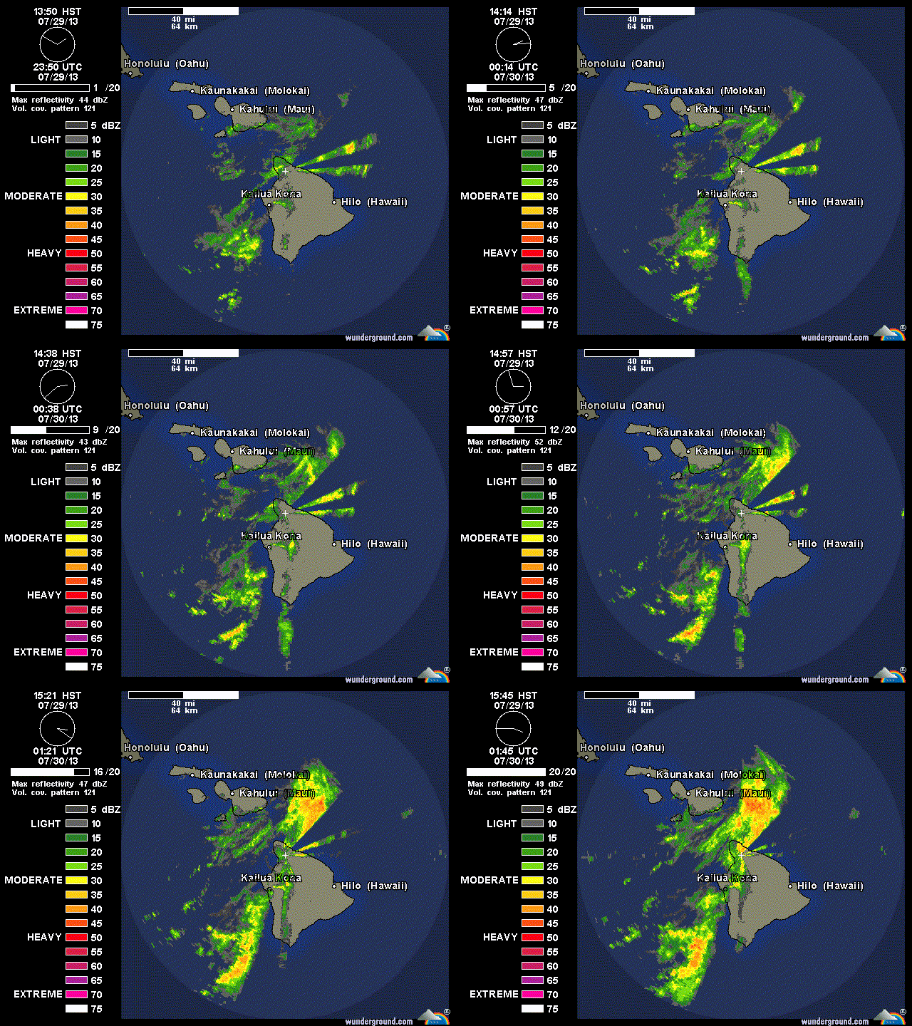
Circulation really torn up by the big island. Looks like a lot of rain after all.

Saved Loop

Image
0 likes   
M a r k
- - - - -
Join us in chat: Storm2K Chatroom Invite. Android and IOS apps also available.

The posts in this forum are NOT official forecasts and should not be used as such. Posts are NOT endorsed by any professional institution or STORM2K.org. For official information and forecasts, please refer to NHC and NWS products.

User avatar
jaguarjace
Category 4
Category 4
Posts: 975
Age: 29
Joined: Sat Jun 11, 2011 7:38 am
Location: Khon Kaen, Thailand

Re: CPAC: FLOSSIE - Tropical Storm

#374 Postby jaguarjace » Mon Jul 29, 2013 8:51 pm

Closer view of the Big Island.
Image

http://www.ssd.noaa.gov/VAAC/kilauea/loop-rgb.html
Please note that this loop will require java
Last edited by jaguarjace on Mon Jul 29, 2013 8:53 pm, edited 1 time in total.
0 likes   
Owner of the Tropical Archive YouTube channel
Web Developer at Force Thirteen
Twitter/X : @force13_support

tolakram
Admin
Admin
Posts: 19165
Age: 60
Joined: Sun Aug 27, 2006 8:23 pm
Location: Florence, KY (name is Mark)

Re: CPAC: FLOSSIE - Tropical Storm

#375 Postby tolakram » Mon Jul 29, 2013 8:52 pm

Saved Radar Loop

Image
0 likes   
M a r k
- - - - -
Join us in chat: Storm2K Chatroom Invite. Android and IOS apps also available.

The posts in this forum are NOT official forecasts and should not be used as such. Posts are NOT endorsed by any professional institution or STORM2K.org. For official information and forecasts, please refer to NHC and NWS products.

User avatar
Yellow Evan
Professional-Met
Professional-Met
Posts: 15954
Age: 25
Joined: Fri Jul 15, 2011 12:48 pm
Location: Henderson, Nevada/Honolulu, HI
Contact:

#376 Postby Yellow Evan » Mon Jul 29, 2013 8:58 pm

When do you all think Flossie will make landfall?
0 likes   

AFWeather
Professional-Met
Professional-Met
Posts: 84
Joined: Mon Jun 14, 2010 6:27 pm
Location: Dayton, OH

Re: CPAC: FLOSSIE - Tropical Storm

#377 Postby AFWeather » Mon Jul 29, 2013 9:13 pm

Image

Did not expect this new convection to form. Thought she was finished! 43KT at 2500 feet. I don't think the downgrade to TD should happen at this update, but seems they've already made up their minds. It's still SE of the center which seems to be a trend. Maui is about to get some gusty winds and rain.
0 likes   

User avatar
Kingarabian
S2K Supporter
S2K Supporter
Posts: 15437
Joined: Sat Aug 08, 2009 3:06 am
Location: Honolulu, Hawaii

Re: CPAC: FLOSSIE - Tropical Storm

#378 Postby Kingarabian » Mon Jul 29, 2013 9:22 pm

They could always retract. The NHC did a few times with Dorian.
0 likes   
RIP Kobe Bryant

User avatar
Yellow Evan
Professional-Met
Professional-Met
Posts: 15954
Age: 25
Joined: Fri Jul 15, 2011 12:48 pm
Location: Henderson, Nevada/Honolulu, HI
Contact:

Re: CPAC: FLOSSIE - Tropical Storm

#379 Postby Yellow Evan » Mon Jul 29, 2013 9:29 pm

Kingarabian wrote:They could always retract. The NHC did a few times with Dorian.


I can't see the CPHC doing that though.
0 likes   

User avatar
Kingarabian
S2K Supporter
S2K Supporter
Posts: 15437
Joined: Sat Aug 08, 2009 3:06 am
Location: Honolulu, Hawaii

Re: CPAC: FLOSSIE - Tropical Storm

#380 Postby Kingarabian » Mon Jul 29, 2013 9:44 pm

Raw ADT T numbers are at 2.9.

Deep convection is building over the center.
0 likes   
RIP Kobe Bryant


Return to “2013”

Who is online

Users browsing this forum: No registered users and 57 guests