ATL: DORIAN - Post-Tropical - Discussion

Moderator: S2k Moderators

Message
Author
User avatar
TheStormExpert
Category 5
Category 5
Posts: 8487
Age: 30
Joined: Wed Feb 16, 2011 5:38 pm
Location: Palm Beach Gardens, FL

Re:

#81 Postby TheStormExpert » Mon Jul 22, 2013 6:31 pm

northjaxpro wrote::uarrow:If it moves as fast as Chantal, I can't see 98L surviving.

If it continues to move at about the speed it is now wouldn't it take 186hrs. which is 7 days to get to the Bahamas if it ever does get there?
0 likes   
The following post is NOT an official forecast and should not be used as such. It is just the opinion of the poster and may or may not be backed by sound meteorological data. It is NOT endorsed by storm2k.org.

User avatar
SFLcane
S2K Supporter
S2K Supporter
Posts: 9606
Age: 46
Joined: Sat Jun 05, 2010 1:44 pm
Location: Lake Worth Florida

Re: ATL: INVEST 98L - Discussion

#82 Postby SFLcane » Mon Jul 22, 2013 6:32 pm

Boy pondering what august/sept might bring if these impressive waves continue.
0 likes   

User avatar
TropicalAnalystwx13
Category 5
Category 5
Posts: 2109
Age: 26
Joined: Tue Jul 19, 2011 8:20 pm
Location: Wilmington, NC
Contact:

#83 Postby TropicalAnalystwx13 » Mon Jul 22, 2013 6:32 pm

Still 30%, surprisingly.

A TROPICAL WAVE ACCOMPANIED BY A SURFACE LOW CONTINUES TO PRODUCE
SHOWER AND THUNDERSTORM ACTIVITY SEVERAL HUNDRED MILES SOUTHEAST OF
THE CAPE VERDE ISLANDS. ENVIRONMENTAL CONDITIONS APPEAR CONDUCIVE
FOR SOME DEVELOPMENT OVER THE NEXT DAY OR SO BEFORE THE WAVE MOVES
INTO A LESS FAVORABLE ENVIRONMENT LATER IN THE WEEK. THIS SYSTEM
HAS A MEDIUM CHANCE...30 PERCENT...OF BECOMING A TROPICAL CYCLONE
DURING THE NEXT 48 HOURS AS IT MOVES WESTWARD TO WEST-NORTHWESTWARD
AT 15 TO 20 MPH. INTERESTS IN THE CAPE VERDE ISLANDS SHOULD
MONITOR THE PROGRESS OF THIS DISTURBANCE.
0 likes   

hurricanekid416
Tropical Storm
Tropical Storm
Posts: 179
Joined: Wed Oct 24, 2012 2:43 pm

#84 Postby hurricanekid416 » Mon Jul 22, 2013 6:45 pm

Wow I'm surprised they stayed at 30%
0 likes   
Personal Forecast Disclaimer:
The posts in this forum are NOT official forecast and should not be used as such. They are just the opinion of the poster and may or may not be backed by sound meteorological data. They are NOT endorsed by any professional institution or storm2k.org. For official information, please refer to the NHC and NWS products.

User avatar
northjaxpro
S2K Supporter
S2K Supporter
Posts: 8900
Joined: Mon Sep 27, 2010 11:21 am
Location: Jacksonville, FL

#85 Postby northjaxpro » Mon Jul 22, 2013 6:46 pm

Well, Chantal was moving as fast as 29 mph at one point in her trek across the Atlantic and generally moved 20-25 mph during its journey until it reached Hispaniola. A storm moving that fast would never get vertically stacked. The same would happen with 98L I think if it moved at the pace Chantal did.
0 likes   
NEVER, EVER SAY NEVER in the tropics and weather in general, and most importantly, with life itself!!

________________________________________________________________________________________

Fay 2008 Beryl 2012 Debby 2012 Colin 2016 Hermine 2016 Julia 2016 Matthew 2016 Irma 2017 Dorian 2019

User avatar
meriland23
Category 5
Category 5
Posts: 1239
Age: 36
Joined: Mon Aug 29, 2011 9:29 pm

#86 Postby meriland23 » Mon Jul 22, 2013 6:47 pm

Distance between where it is now and cuba is 3900 miles, it would have to move approx 21 MPH to get there in 186 hrs.. just a rough estimate.
0 likes   
The posts in this forum are NOT official forecast and should not be used as such. They are just the opinion of the poster and may or may not be backed by sound meteorological data. They are NOT endorsed by any professional institution or storm2k.org. For official information, please refer to the NHC and NWS products.

User avatar
cycloneye
Admin
Admin
Posts: 139081
Age: 67
Joined: Thu Oct 10, 2002 10:54 am
Location: San Juan, Puerto Rico

Re: ATL: INVEST 98L - Discussion

#87 Postby cycloneye » Mon Jul 22, 2013 6:50 pm

They are the experts that know all of what is going on with the system with the many tools they have and decided that it didn't warranted more than 30% at this time.
0 likes   
Visit the Caribbean-Central America Weather Thread where you can find at first post web cams,radars
and observations from Caribbean basin members Click Here

ozonepete
Professional-Met
Professional-Met
Posts: 4743
Joined: Mon Sep 07, 2009 3:23 pm
Location: From Ozone Park, NYC / Now in Brooklyn, NY

ATL: INVEST 98L - Discussion

#88 Postby ozonepete » Mon Jul 22, 2013 7:18 pm

Colorado State / NCAR track guidance from 18Z; all models, GFS ensemble and intensity:

Image

Image

Image
0 likes   

User avatar
cycloneye
Admin
Admin
Posts: 139081
Age: 67
Joined: Thu Oct 10, 2002 10:54 am
Location: San Juan, Puerto Rico

Re: ATL: INVEST 98L - Discussion

#89 Postby cycloneye » Mon Jul 22, 2013 7:21 pm

TWD Special Feature.

...SPECIAL FEATURE...

AN ATLANTIC OCEAN TROPICAL WAVE IS ALONG 18N21W 14N22W 9N23W...
MOVING WESTWARD 10 KNOTS. CONVECTIVE PRECIPITATION...NUMEROUS
STRONG FROM 12N TO 14N BETWEEN 21W AND 22W. SCATTERED STRONG
FROM 9N TO 12N BETWEEN 21W AND 26W. ENVIRONMENTAL CONDITIONS ARE
EXPECTED TO BE FAVORABLE FOR DEVELOPMENT INTO A TROPICAL CYCLONE
DURING THE NEXT DAY OR SO... BEFORE BECOMING LESS CONDUCIVE FOR
DEVELOPMENT LATER IN THE WEEK. THIS SYSTEM HAS A MEDIUM CHANCE
OF BECOMING A TROPICAL CYCLONE DURING THE NEXT 48 HOURS.
INTERESTS IN THE CAPE VERDE ISLANDS SHOULD MONITOR THE PROGRESS
OF THIS DISTURBANCE.
0 likes   
Visit the Caribbean-Central America Weather Thread where you can find at first post web cams,radars
and observations from Caribbean basin members Click Here

ozonepete
Professional-Met
Professional-Met
Posts: 4743
Joined: Mon Sep 07, 2009 3:23 pm
Location: From Ozone Park, NYC / Now in Brooklyn, NY

Re: ATL: INVEST 98L - Discussion

#90 Postby ozonepete » Mon Jul 22, 2013 7:21 pm

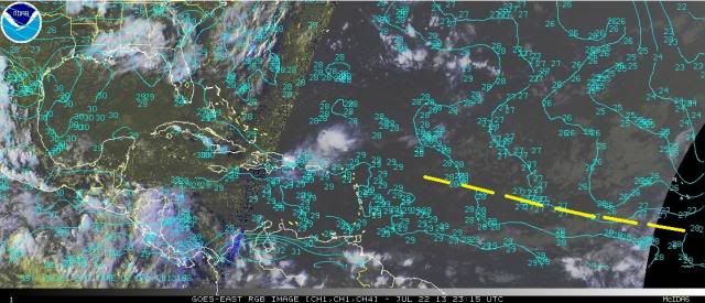
I don't get where there'll be any problem with SSTs. Given the rough track this is going on, and consensus is pretty tightly clustered, this will never go over water lower than 27C. I drew in the roughly expected path for the next few days over an RGB sat image with current SSTs.

Image
0 likes   

ozonepete
Professional-Met
Professional-Met
Posts: 4743
Joined: Mon Sep 07, 2009 3:23 pm
Location: From Ozone Park, NYC / Now in Brooklyn, NY

Re: ATL: INVEST 98L - Models

#91 Postby ozonepete » Mon Jul 22, 2013 7:23 pm

:uarrow: I see you moved me Luis. Thanks. :wink:
0 likes   

User avatar
cycloneye
Admin
Admin
Posts: 139081
Age: 67
Joined: Thu Oct 10, 2002 10:54 am
Location: San Juan, Puerto Rico

Re: ATL: INVEST 98L - Models

#92 Postby cycloneye » Mon Jul 22, 2013 7:26 pm

ozonepete wrote::uarrow: I see you moved me Luis. Thanks. :wink:


Yes,that happens sometimes to some members. :)
0 likes   
Visit the Caribbean-Central America Weather Thread where you can find at first post web cams,radars
and observations from Caribbean basin members Click Here

User avatar
cycloneye
Admin
Admin
Posts: 139081
Age: 67
Joined: Thu Oct 10, 2002 10:54 am
Location: San Juan, Puerto Rico

Re: ATL: INVEST 98L - Discussion

#93 Postby cycloneye » Mon Jul 22, 2013 7:28 pm

SSD Dvorak goes up from too weak to 1.0.

22/2345 UTC 12.2N 21.8W T1.0/1.0 98L -- Atlantic
0 likes   
Visit the Caribbean-Central America Weather Thread where you can find at first post web cams,radars
and observations from Caribbean basin members Click Here

User avatar
cycloneye
Admin
Admin
Posts: 139081
Age: 67
Joined: Thu Oct 10, 2002 10:54 am
Location: San Juan, Puerto Rico

Re: ATL: INVEST 98L - Discussion

#94 Postby cycloneye » Mon Jul 22, 2013 7:37 pm

00z Best Track.

AL, 98, 2013072300, , BEST, 0, 123N, 213W, 25, 1010, LO
0 likes   
Visit the Caribbean-Central America Weather Thread where you can find at first post web cams,radars
and observations from Caribbean basin members Click Here

User avatar
cycloneye
Admin
Admin
Posts: 139081
Age: 67
Joined: Thu Oct 10, 2002 10:54 am
Location: San Juan, Puerto Rico

Re: ATL: INVEST 98L - Models

#95 Postby cycloneye » Mon Jul 22, 2013 7:38 pm

TROPICAL CYCLONE GUIDANCE MESSAGE
NWS NATIONAL HURRICANE CENTER MIAMI FL
0035 UTC TUE JUL 23 2013

DISCLAIMER...NUMERICAL MODELS ARE SUBJECT TO LARGE ERRORS.
PLEASE REFER TO NHC OFFICIAL FORECASTS FOR TROPICAL CYCLONE
AND SUBTROPICAL CYCLONE INFORMATION.

ATLANTIC OBJECTIVE AIDS FOR

DISTURBANCE INVEST (AL982013) 20130723 0000 UTC

...00 HRS... ...12 HRS... ...24 HRS. .. ...36 HRS...
130723 0000 130723 1200 130724 0000 130724 1200

LAT LON LAT LON LAT LON LAT LON
BAMS 12.3N 21.3W 12.9N 23.6W 13.7N 26.7W 15.0N 30.3W
BAMD 12.3N 21.3W 12.7N 23.8W 13.5N 26.6W 14.7N 29.3W
BAMM 12.3N 21.3W 13.0N 23.8W 14.0N 26.6W 15.4N 29.9W
LBAR 12.3N 21.3W 12.8N 24.4W 13.9N 28.0W 15.5N 31.7W
SHIP 25KTS 33KTS 42KTS 49KTS
DSHP 25KTS 33KTS 42KTS 49KTS

...48 HRS... ...72 HRS... ...96 HRS. .. ..120 HRS...
130725 0000 130726 0000 130727 0000 130728 0000

LAT LON LAT LON LAT LON LAT LON
BAMS 16.2N 34.4W 17.2N 43.0W 17.9N 50.9W 18.6N 57.9W
BAMD 16.2N 32.2W 18.8N 38.0W 20.2N 42.8W 19.9N 45.8W
BAMM 17.0N 33.5W 19.8N 40.8W 21.5N 47.3W 22.3N 53.0W
LBAR 17.4N 35.2W 20.7N 40.9W 22.6N 45.9W 27.1N 46.4W
SHIP 51KTS 50KTS 44KTS 41KTS
DSHP 51KTS 50KTS 44KTS 41KTS

...INITIAL CONDITIONS...
LATCUR = 12.3N LONCUR = 21.3W DIRCUR = 270DEG SPDCUR = 16KT
LATM12 = 12.2N LONM12 = 17.7W DIRM12 = 266DEG SPDM12 = 14KT
LATM24 = 12.6N LONM24 = 15.3W
WNDCUR = 25KT RMAXWD = 80NM WNDM12 = 20KT
CENPRS = 1010MB OUTPRS = 1013MB OUTRAD = 150NM SDEPTH = M
RD34NE = 0NM RD34SE = 0NM RD34SW = 0NM RD34NW = 0NM

0 likes   
Visit the Caribbean-Central America Weather Thread where you can find at first post web cams,radars
and observations from Caribbean basin members Click Here

User avatar
meriland23
Category 5
Category 5
Posts: 1239
Age: 36
Joined: Mon Aug 29, 2011 9:29 pm

#96 Postby meriland23 » Mon Jul 22, 2013 7:45 pm

What will be working against the system later in the week, and is it less favorable than Chantal had?
0 likes   
The posts in this forum are NOT official forecast and should not be used as such. They are just the opinion of the poster and may or may not be backed by sound meteorological data. They are NOT endorsed by any professional institution or storm2k.org. For official information, please refer to the NHC and NWS products.

User avatar
TropicalAnalystwx13
Category 5
Category 5
Posts: 2109
Age: 26
Joined: Tue Jul 19, 2011 8:20 pm
Location: Wilmington, NC
Contact:

#97 Postby TropicalAnalystwx13 » Mon Jul 22, 2013 7:50 pm

Image
0 likes   

User avatar
Gustywind
Category 5
Category 5
Posts: 12334
Joined: Mon Sep 03, 2007 7:29 am
Location: Baie-Mahault, GUADELOUPE

#98 Postby Gustywind » Mon Jul 22, 2013 7:52 pm

Latest from NRL:

http://www.nrlmry.navy.mil/tc-bin/tc_ho ... bw&PROD=ir

20130723.0000.98LINVEST.25kts-1010mb-123N-213W.
0 likes   

User avatar
Blown Away
S2K Supporter
S2K Supporter
Posts: 9861
Joined: Wed May 26, 2004 6:17 am

Re: ATL: INVEST 98L - Models

#99 Postby Blown Away » Mon Jul 22, 2013 7:54 pm

Image
TAFB 72 Hour Position
0 likes   
Hurricane Eye Experience: David 79, Irene 99, Frances 04, Jeanne 04, Wilma 05...
Hurricane Brush Experience: Andrew 92, Erin 95, Floyd 99, Matthew 16, Irma 17, Ian 22, Nicole 22…

User avatar
ronjon
Category 5
Category 5
Posts: 4671
Joined: Fri Aug 19, 2005 5:17 pm
Location: Hernando Beach, FL

Re: ATL: INVEST 98L - Discussion

#100 Postby ronjon » Mon Jul 22, 2013 7:57 pm

Quite the vigorous circulation and massive convection for so far east in the Atlantic. I would expect we'll have a TD within the next day or so. It has a huge moisture envelope and with that present I suspect the dry air problem is a bit over emphasized at this time. Now shear could be an issue down the road. Has anyone looked at historical storm tracks for systems forming this far east? I'd bet it'll probably recurve prior to the US - Bermuda threat maybe? Although there is a fairly massive ridge progged in the mid-atlantic in the next 4-5 days.
0 likes   


Return to “2013”

Who is online

Users browsing this forum: No registered users and 98 guests