ATL: INVEST 96L - Discussion
Moderator: S2k Moderators
-
hurricanehunter69
- Category 1

- Posts: 330
- Joined: Sun May 16, 2010 5:21 pm
- Location: New Orleans
ATL: INVEST 96L - Models
Regardless of what the models say. The NHC (with higher percentages ), and satelite loop, says it's developing. Question is....will it develop in time to give August it's third named storm? http://www.ssd.noaa.gov/eumet/eatl/flash-avn.html
0 likes
-
tolakram
- Admin

- Posts: 19165
- Age: 60
- Joined: Sun Aug 27, 2006 8:23 pm
- Location: Florence, KY (name is Mark)
Re: ATL: INVEST 96L - Discussion
ZCZC MIATWOAT ALL
TTAA00 KNHC DDHHMM
TROPICAL WEATHER OUTLOOK
NWS NATIONAL HURRICANE CENTER MIAMI FL
200 AM EDT SAT AUG 31 2013
FOR THE NORTH ATLANTIC...CARIBBEAN SEA AND THE GULF OF MEXICO...
1. A BROAD AREA OF LOW PRESSURE ASSOCIATED WITH A TROPICAL WAVE IS
LOCATED NEAR THE WEST COAST OF AFRICA. ENVIRONMENTAL CONDITIONS
APPEAR CONDUCIVE FOR DEVELOPMENT WHEN THE LOW REACHES THE ATLANTIC
OCEAN...AND THIS SYSTEM HAS THE POTENTIAL TO BECOME A TROPICAL
DEPRESSION DURING THE NEXT COUPLE OF DAYS AS IT MOVES TOWARD THE
CAPE VERDE ISLANDS. AFTER THAT TIME...CONDITIONS ARE EXPECTED TO BE
LESS CONDUCIVE FOR DEVELOPMENT AS THE DISTURBANCE MOVES TOWARD THE
WEST-NORTHWEST OVER THE EASTERN ATLANTIC. THIS SYSTEM HAS A MEDIUM
CHANCE...50 PERCENT...OF BECOMING A TROPICAL CYCLONE DURING THE
NEXT 48 HOURS...AND A MEDIUM CHANCE...50 PERCENT...OF BECOMING A
TROPICAL CYCLONE DURING THE NEXT 5 DAYS. WHETHER OR NOT THIS
DISTURBANCE BECOMES A TROPICAL CYCLONE...IT WILL LIKELY BRING
CLOUDINESS AND THUNDERSTORMS TO PORTIONS OF THE CAPE VERDE ISLANDS
DURING THE NEXT COUPLE OF DAYS.
-snip-
FIVE-DAY FORMATION PROBABILITIES ARE EXPERIMENTAL IN 2013. COMMENTS
ON THE EXPERIMENTAL FORECASTS CAN BE PROVIDED AT...
HTTP://WWW.NWS.NOAA.GOV/SURVEY/NWS-SURVEY.PHP?CODE=ETWO
FORECASTER BRENNAN
0 likes
M a r k
- - - - -
Join us in chat: Storm2K Chatroom Invite. Android and IOS apps also available.
The posts in this forum are NOT official forecasts and should not be used as such. Posts are NOT endorsed by any professional institution or STORM2K.org. For official information and forecasts, please refer to NHC and NWS products.

Its pretty much over at this point, it failed to even exit Africa and already appears to be decoupled by easterly shear, dried out, and winding down. Pretty bad when the waves cant even make it off of Africa.
0 likes
The above post is not official and should not be used as such. It is the opinion of the poster and may or may not be backed by sound meteorological data. It is not endorsed by any professional institution or storm2k.org. For official information, please refer to the NHC and NWS products.


Re: ATL: INVEST 96L - Models
Actually, the NHC is saying it has a 50/50 chance: it could go either way. And Dorian showed us how deceptive satellite presentations can be.hurricanehunter69 wrote:Regardless of what the models say. The NHC (with higher percentages ), and satelite loop, says it's developing. Question is....will it develop in time to give August it's third named storm? http://www.ssd.noaa.gov/eumet/eatl/flash-avn.html
0 likes
-
cycloneye

- Admin
- Posts: 139122
- Age: 67
- Joined: Thu Oct 10, 2002 10:54 am
- Location: San Juan, Puerto Rico
Re: ATL: INVEST 96L - Discussion
A BROAD AREA OF LOW PRESSURE ASSOCIATED WITH A TROPICAL WAVE IS
MOVING WEST-NORTHWESTWARD AND IS NOW LOCATED OVER WATER NEAR THE
WEST COAST OF AFRICA. CLOUDINESS AND SHOWERS HAVE DIMINISHED SINCE
YESTERDAY AND ENVIRONMENTAL CONDITIONS APPEAR TO BE LESS CONDUCIVE
THAN PREVIOUSLY ANTICIPATED. HOWEVER...THE SYSTEM STILL HAS SOME
POTENTIAL TO BECOME A TROPICAL DEPRESSION DURING THE NEXT DAY OR
TWO BEFORE IT MOVES FURTHER INTO THE EASTERN ATLANTIC WHERE
CONDITIONS APPEAR TO BE HOSTILE FOR DEVELOPMENT. THIS SYSTEM HAS A
MEDIUM CHANCE...40 PERCENT...OF BECOMING A TROPICAL CYCLONE DURING
THE NEXT 48 HOURS...AND A MEDIUM CHANCE...40 PERCENT...OF BECOMING
A TROPICAL CYCLONE DURING THE NEXT 5 DAYS.
0 likes
Visit the Caribbean-Central America Weather Thread where you can find at first post web cams,radars
and observations from Caribbean basin members Click Here
and observations from Caribbean basin members Click Here
-
ninel conde
- Category 5

- Posts: 1245
- Joined: Mon Aug 04, 2008 2:18 pm
i think 40% is still too high.
0 likes
The posts in this forum are NOT official forecast and should not be used as such. They are just the opinion of the poster and may or may not be backed by sound meteorological data. They are NOT endorsed by any professional institution or storm2k.org. For official information, please refer to the NHC and NWS products.
-
cycloneye
- Admin
- Posts: 139122
- Age: 67
- Joined: Thu Oct 10, 2002 10:54 am
- Location: San Juan, Puerto Rico
Re: ATL: INVEST 96L - Models
hurricanehunter69 wrote:Regardless of what the models say. The NHC (with higher percentages ), and satelite loop, says it's developing. Question is....will it develop in time to give August it's third named storm? http://www.ssd.noaa.gov/eumet/eatl/flash-avn.html
All indications are that August will only have 2 named storms.
0 likes
Visit the Caribbean-Central America Weather Thread where you can find at first post web cams,radars
and observations from Caribbean basin members Click Here
and observations from Caribbean basin members Click Here
-
cycloneye
- Admin
- Posts: 139122
- Age: 67
- Joined: Thu Oct 10, 2002 10:54 am
- Location: San Juan, Puerto Rico
Re: ATL: INVEST 96L - Discussion
Winds down to 25kts.
AL, 96, 2013083112, , BEST, 0, 155N, 175W, 25, 1008, LO
AL, 96, 2013083112, , BEST, 0, 155N, 175W, 25, 1008, LO
0 likes
Visit the Caribbean-Central America Weather Thread where you can find at first post web cams,radars
and observations from Caribbean basin members Click Here
and observations from Caribbean basin members Click Here
-
Gustywind

- Category 5
- Posts: 12334
- Joined: Mon Sep 03, 2007 7:29 am
- Location: Baie-Mahault, GUADELOUPE
TROPICAL WEATHER DISCUSSION
NWS NATIONAL HURRICANE CENTER MIAMI FL
805 AM EDT SAT AUG 31 2013
...SPECIAL FEATURES...
A TROPICAL WAVE ASSOCIATED WITH A 1008 MB LOW PRESSURE IS COMING
OFF THE AFRICAN COAST. ITS AXIS EXTENDS FROM 20N16W TO THE LOW
NEAR 15N16W TO 10N16N AND IS MOVING W NEAR 5 KT. THE SURFACE
CYCLONIC CIRCULATION ASSOCIATED WITH THE LOW EXTENDS UP TO THE
MIDDLE LEVELS. TOTAL PRECIPITABLE WATER IMAGERY SHOW THE WAVE IS
WITHIN A MODERATE TO HIGH MOIST ENVIRONMENT. STRONG
SOUTHEASTERLY WIND SHEAR IS KEEPING A CLUSTER OF
MODERATE/ISOLATED STRONG CONVECTION NW OF THE LOW PRESSURE
CENTER FROM 13N-18N BETWEEN 17W-22W. ENVIRONMENTAL CONDITIONS
APPEAR CONDUCIVE FOR DEVELOPMENT AND THIS SYSTEM HAS THE
POTENTIAL TO BECOME A TROPICAL DEPRESSION DURING THE NEXT COUPLE
OF DAYS AS IT MOVES TOWARD THE CAPE VERDE ISLANDS. RAINSHOWERS
AND THUNDERSTORMS ARE EXPECTED IN PORTIONS OF THE CAPE VERDE
ISLANDS IN THE NEXT COUPLE OF DAYS.
0 likes
-
tolakram
- Admin
- Posts: 19165
- Age: 60
- Joined: Sun Aug 27, 2006 8:23 pm
- Location: Florence, KY (name is Mark)
Re: ATL: INVEST 96L - Discussion
Here is the vorticity map from the 6Z GFS in 24 hours. In 48 hours this is almost completely gone.
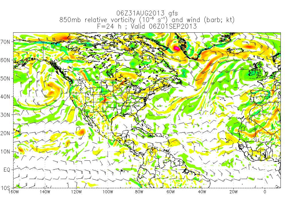
I really don't think this is going to develop.
Personal Forecast Disclaimer:
The posts in this forum are NOT official forecast and should not be used as such. They are just the opinion of the poster and may or may not be backed by sound meteorological data. They are NOT endorsed by any professional institution or storm2k.org. For official information, please refer to the NHC and NWS products.
0 likes
M a r k
- - - - -
Join us in chat: Storm2K Chatroom Invite. Android and IOS apps also available.
The posts in this forum are NOT official forecasts and should not be used as such. Posts are NOT endorsed by any professional institution or STORM2K.org. For official information and forecasts, please refer to NHC and NWS products.
- - - - -
Join us in chat: Storm2K Chatroom Invite. Android and IOS apps also available.
The posts in this forum are NOT official forecasts and should not be used as such. Posts are NOT endorsed by any professional institution or STORM2K.org. For official information and forecasts, please refer to NHC and NWS products.
-
hurricanehunter69
- Category 1
- Posts: 330
- Joined: Sun May 16, 2010 5:21 pm
- Location: New Orleans
Re: ATL: INVEST 96L - Models
abajan wrote:Actually, the NHC is saying it has a 50/50 chance: it could go either way. And Dorian showed us how deceptive satellite presentations can be.hurricanehunter69 wrote:Regardless of what the models say. The NHC (with higher percentages ), and satelite loop, says it's developing. Question is....will it develop in time to give August it's third named storm? http://www.ssd.noaa.gov/eumet/eatl/flash-avn.html
I was going with the probs and satelite at 11pm last night. Damn, burned again! Question now is.....? Is this the last time I get burned by a system in 2013....? Probably not.
0 likes
-
cycloneye
- Admin
- Posts: 139122
- Age: 67
- Joined: Thu Oct 10, 2002 10:54 am
- Location: San Juan, Puerto Rico
Re: ATL: INVEST 96L - Discussion
Sad information as the strong wave now 96L has caused many deaths in 6 African countries. This information was posted by Dr Jeff Masters.
Severe flooding is causing chaos across several countries in the Sahel region of Africa. To date, more than 200,000 people have been affected in six countries, including Burkina Faso, Gambia, Guinea, Mali, Niger and Senegal. Buildings have collapsed, roads have been rendered impassable, and valuable farmland is submerged beneath flood water.
In Mali, at least 55 people have been killed by heavy rains that lashed almost all the neighbourhoods of the capital, Bamako. Thousands of families have been displaced after their houses collapsed in Boconi Flabougou, Korofina, Banconi Laïbougou, Sébéniko, Lafiabougou and Babiabougou.
“I have never seen such rain and flooding in my life,” said Malick Doumbia, a 52-year-old resident of Bamako. “We have lost everything.”
Volunteers at the Mali Red Cross, in collaboration with the government’s civil protection office, were immediately deployed to provide assistance to affected families with essential relief items, including mosquito nets, blankets, sleeping mats, jerry cans, hygiene kits and tents.
“Red Cross volunteers are participating in rescue operations while doing a rapid assessment of the damage caused by the floods,” said Mamadou Traoré, Secretary General of the Mali Red Cross.
Volunteers have also been mobilized in other flood-affected countries, providing much needed support to those who have had their lives washed away.
“Based on predictions of severe rainfall in West Africa, we were able to pre-position stock emergency relief items in most of the countries,” said Chiran Livera, Disaster Response Manager at the International Federation of Red Cross and Red Crescent Societies (IFRC) in Dakar. “This has allowed us to provide immediate assistance to people.”
Strong wave now 96L on August 28.


http://reliefweb.int/report/mali/red-cr ... toll-sahel
Severe flooding is causing chaos across several countries in the Sahel region of Africa. To date, more than 200,000 people have been affected in six countries, including Burkina Faso, Gambia, Guinea, Mali, Niger and Senegal. Buildings have collapsed, roads have been rendered impassable, and valuable farmland is submerged beneath flood water.
In Mali, at least 55 people have been killed by heavy rains that lashed almost all the neighbourhoods of the capital, Bamako. Thousands of families have been displaced after their houses collapsed in Boconi Flabougou, Korofina, Banconi Laïbougou, Sébéniko, Lafiabougou and Babiabougou.
“I have never seen such rain and flooding in my life,” said Malick Doumbia, a 52-year-old resident of Bamako. “We have lost everything.”
Volunteers at the Mali Red Cross, in collaboration with the government’s civil protection office, were immediately deployed to provide assistance to affected families with essential relief items, including mosquito nets, blankets, sleeping mats, jerry cans, hygiene kits and tents.
“Red Cross volunteers are participating in rescue operations while doing a rapid assessment of the damage caused by the floods,” said Mamadou Traoré, Secretary General of the Mali Red Cross.
Volunteers have also been mobilized in other flood-affected countries, providing much needed support to those who have had their lives washed away.
“Based on predictions of severe rainfall in West Africa, we were able to pre-position stock emergency relief items in most of the countries,” said Chiran Livera, Disaster Response Manager at the International Federation of Red Cross and Red Crescent Societies (IFRC) in Dakar. “This has allowed us to provide immediate assistance to people.”
Strong wave now 96L on August 28.
http://reliefweb.int/report/mali/red-cr ... toll-sahel
0 likes
Visit the Caribbean-Central America Weather Thread where you can find at first post web cams,radars
and observations from Caribbean basin members Click Here
and observations from Caribbean basin members Click Here
-
Gustywind
- Category 5
- Posts: 12334
- Joined: Mon Sep 03, 2007 7:29 am
- Location: Baie-Mahault, GUADELOUPE
Re: ATL: INVEST 96L - Discussion
cycloneye wrote:Sad information as the strong wave now 96L has caused many deaths in 6 African countries.
Severe flooding is causing chaos across several countries in the Sahel region of Africa. To date, more than 200,000 people have been affected in six countries, including Burkina Faso, Gambia, Guinea, Mali, Niger and Senegal. Buildings have collapsed, roads have been rendered impassable, and valuable farmland is submerged beneath flood water.
In Mali, at least 55 people have been killed by heavy rains that lashed almost all the neighbourhoods of the capital, Bamako. Thousands of families have been displaced after their houses collapsed in Boconi Flabougou, Korofina, Banconi Laïbougou, Sébéniko, Lafiabougou and Babiabougou.
“I have never seen such rain and flooding in my life,” said Malick Doumbia, a 52-year-old resident of Bamako. “We have lost everything.”
Volunteers at the Mali Red Cross, in collaboration with the government’s civil protection office, were immediately deployed to provide assistance to affected families with essential relief items, including mosquito nets, blankets, sleeping mats, jerry cans, hygiene kits and tents.
“Red Cross volunteers are participating in rescue operations while doing a rapid assessment of the damage caused by the floods,” said Mamadou Traoré, Secretary General of the Mali Red Cross.
Volunteers have also been mobilized in other flood-affected countries, providing much needed support to those who have had their lives washed away.
“Based on predictions of severe rainfall in West Africa, we were able to pre-position stock emergency relief items in most of the countries,” said Chiran Livera, Disaster Response Manager at the International Federation of Red Cross and Red Crescent Societies (IFRC) in Dakar. “This has allowed us to provide immediate assistance to people.”
http://reliefweb.int/report/mali/red-cr ... toll-sahel
0 likes
-
hurricanes1234
- Category 5
- Posts: 2903
- Joined: Sat Jul 28, 2012 6:19 pm
- Location: Trinidad and Tobago
Re: ATL: INVEST 96L - Discussion
Development potential is virtually gone. Down to 30% for 48 hours and 5 days. In my opinion, this should dissipate completely by tomorrow afternoon. I would give it a near 0% chance of development at all.
1. A BROAD AREA OF LOW PRESSURE ASSOCIATED WITH A TROPICAL WAVE IS MOVING WEST-NORTHWESTWARD AND IS NOW LOCATED OVER WATER NEAR THE WEST COAST OF AFRICA. CLOUDINESS AND SHOWERS REMAIN DISORGANIZED AND SINCE ENVIRONMENTAL CONDITIONS HAVE BECOME LESS FAVORABLE FOR DEVELOPMENT...THE POTENTIAL FOR A TROPICAL DEPRESSION TO FORM HAS DIMINISHED. THIS SYSTEM HAS A MEDIUM CHANCE...30 PERCENT...OF BECOMING A TROPICAL CYCLONE DURING THE NEXT 48 HOURS...AND A MEDIUM CHANCE...30 PERCENT...OF BECOMING A TROPICAL CYCLONE DURING THE NEXT 5 DAYS...AS IT MOVES OVER THE EASTERN ATLANTIC.
Personal Forecast Disclaimer: The posts in this forum are NOT official forecast and should not be used as such. They are just the opinion of the poster and may or may not be backed by sound meteorological data. They are NOT endorsed by any professional institution or storm2k.org. For official information, please refer to the NHC and NWS products.
0 likes
PLEASE NOTE: With the exception of information from weather agencies that I may copy and paste here, my posts will NEVER be official, since I am NOT a meteorologist. They are solely my amateur opinion, and may or may not be accurate. Therefore, please DO NOT use them as official details, particularly when making important decisions. Thank you.
-
ninel conde
- Category 5
- Posts: 1245
- Joined: Mon Aug 04, 2008 2:18 pm
yea, 0% seems more likely.
0 likes
The posts in this forum are NOT official forecast and should not be used as such. They are just the opinion of the poster and may or may not be backed by sound meteorological data. They are NOT endorsed by any professional institution or storm2k.org. For official information, please refer to the NHC and NWS products.
Could still become a depression, the circulation seems well defined enough, but it will all come down to if the convection ever builds near the center.
0 likes
The above post is not official and should not be used as such. It is the opinion of the poster and may or may not be backed by sound meteorological data. It is not endorsed by any professional institution or storm2k.org. For official information, please refer to the NHC and NWS products.
-
cycloneye
- Admin
- Posts: 139122
- Age: 67
- Joined: Thu Oct 10, 2002 10:54 am
- Location: San Juan, Puerto Rico
Re: ATL: INVEST 96L - Discussion
Down to 20-20.
A BROAD AREA OF LOW PRESSURE ASSOCIATED WITH A TROPICAL WAVE IS
OVER THE EASTERN ATLANTIC BETWEEN THE CAPE VERDE ISLANDS AND THE
COAST OF AFRICA. WHILE THE ASSOCIATED CLOUDINESS AND SHOWERS SHOW
SOME SIGNS OF ORGANIZATION...ENVIRONMENTAL CONDITIONS HAVE BECOME
LESS FAVORABLE FOR DEVELOPMENT...AND THE POTENTIAL FOR A TROPICAL
DEPRESSION TO FORM HAS DIMINISHED. THIS SYSTEM HAS A LOW CHANCE...
20 PERCENT...OF BECOMING A TROPICAL CYCLONE DURING THE NEXT
48 HOURS...AND A LOW CHANCE...20 PERCENT...OF BECOMING A TROPICAL
CYCLONE DURING THE NEXT 5 DAYS...AS IT MOVES GENERALLY
WEST-NORTHWESTWARD OVER THE EASTERN ATLANTIC.
0 likes
Visit the Caribbean-Central America Weather Thread where you can find at first post web cams,radars
and observations from Caribbean basin members Click Here
and observations from Caribbean basin members Click Here
-
Gustywind
- Category 5
- Posts: 12334
- Joined: Mon Sep 03, 2007 7:29 am
- Location: Baie-Mahault, GUADELOUPE
8 PM Discussion.
TROPICAL WAVE OFF THE COAST OF W AFRICA EXTENDS FROM 19N18W
THROUGH A 1008 MB LOW NEAR 16N18W TO 10N18W MOVING W NEAR 5 KT.
A BROAD SURGE OF DEEP MOISTURE COVERS THE FAR E ATLC E OF THE
CAPE VERDE ISLANDS ENCOMPASSING THIS WAVE AS DEPICTED ON THE
TOTAL PRECIPITABLE WATER IMAGERY. SCATTERED MODERATE/ISOLATED
STRONG CONVECTION IS W OF THE WAVE FROM 14N-17N BETWEEN 20W-23W.
0 likes
-
hurricanes1234
- Category 5
- Posts: 2903
- Joined: Sat Jul 28, 2012 6:19 pm
- Location: Trinidad and Tobago
Re: ATL: INVEST 96L - Discussion
Pretty much done at this point, the structure is most probably a total mess, because of intensely unfavourable conditions.
Personal Forecast Disclaimer: The posts in this forum are NOT official forecast and should not be used as such. They are just the opinion of the poster and may or may not be backed by sound meteorological data. They are NOT endorsed by any professional institution or storm2k.org. For official information, please refer to the NHC and NWS products.
Personal Forecast Disclaimer: The posts in this forum are NOT official forecast and should not be used as such. They are just the opinion of the poster and may or may not be backed by sound meteorological data. They are NOT endorsed by any professional institution or storm2k.org. For official information, please refer to the NHC and NWS products.
0 likes
PLEASE NOTE: With the exception of information from weather agencies that I may copy and paste here, my posts will NEVER be official, since I am NOT a meteorologist. They are solely my amateur opinion, and may or may not be accurate. Therefore, please DO NOT use them as official details, particularly when making important decisions. Thank you.
Who is online
Users browsing this forum: No registered users and 52 guests