ATL: GABRIELLE - Models

Moderator: S2k Moderators

Message
Author
tolakram
Admin
Admin
Posts: 19165
Age: 60
Joined: Sun Aug 27, 2006 8:23 pm
Location: Florence, KY (name is Mark)

Re: Re:

#261 Postby tolakram » Wed Sep 04, 2013 2:28 pm

ninel conde wrote:thats the winterlike pattern ive been talking about.


No pattern setting up, just one strong trough digging down that will be gone in a few days.

A few pages back someone was pointing to the WV image as evidence a ridge was building back in, now the opposite. Everyone needs to be careful with these blanket statements that don't have any meteorological backing. It's one thing to show today's loop and connect it to some longer term model runs, it's quite another to just point to today's loop as the start of a pattern with nothing to back it up.

You can see the various GFS predictions on this page: http://www.tropicaltidbits.com/analysis/models/gfs/

More model runs here: http://www.meteo.psu.edu/ewall/ewall.html
0 likes   
M a r k
- - - - -
Join us in chat: Storm2K Chatroom Invite. Android and IOS apps also available.

The posts in this forum are NOT official forecasts and should not be used as such. Posts are NOT endorsed by any professional institution or STORM2K.org. For official information and forecasts, please refer to NHC and NWS products.

User avatar
gatorcane
S2K Supporter
S2K Supporter
Posts: 23499
Age: 46
Joined: Sun Mar 13, 2005 3:54 pm
Location: Boca Raton, FL

#262 Postby gatorcane » Wed Sep 04, 2013 2:51 pm

12Z GFS Ensembles below:

Image
0 likes   

Aric Dunn
Category 5
Category 5
Posts: 21228
Age: 41
Joined: Sun Sep 19, 2004 9:58 pm
Location: Ready for the Chase.
Contact:

Re:

#263 Postby Aric Dunn » Wed Sep 04, 2013 2:55 pm

gatorcane wrote:12Z GFS Ensembles below:

[img]http://img713.imageshack.us/img713/9156/uu2g.png[/ig]


lol they really need to change that image .. they are barely usable.. lol
0 likes   
Note: If I make a post that is brief. Please refer back to previous posts for the analysis or reasoning. I do not re-write/qoute what my initial post said each time.
If there is nothing before... then just ask :)

Space & Atmospheric Physicist, Embry-Riddle Aeronautical University,
I believe the sky is falling...

User avatar
thetruesms
Professional-Met
Professional-Met
Posts: 844
Age: 40
Joined: Thu Aug 16, 2007 1:14 pm
Location: Tallahasee, FL
Contact:

Re: Re:

#264 Postby thetruesms » Wed Sep 04, 2013 3:07 pm

Aric Dunn wrote:lol they really need to change that image .. they are barely usable.. lol
I love the probabilistic graphics for GEFS from Albany, but they run so far behind - most recent is the 6Z set :cry:

Image
0 likes   

Aric Dunn
Category 5
Category 5
Posts: 21228
Age: 41
Joined: Sun Sep 19, 2004 9:58 pm
Location: Ready for the Chase.
Contact:

Re: Re:

#265 Postby Aric Dunn » Wed Sep 04, 2013 3:17 pm

thetruesms wrote:
Aric Dunn wrote:lol they really need to change that image .. they are barely usable.. lol
I love the probabilistic graphics for GEFS from Albany, but they run so far behind - most recent is the 6Z set :cry:

[img]http://i.imgur.com/Pf8gS9S.png[/i\mg]


yeah they are nice. just meant they have not changed that image graphic in as long as i can remember..
0 likes   
Note: If I make a post that is brief. Please refer back to previous posts for the analysis or reasoning. I do not re-write/qoute what my initial post said each time.
If there is nothing before... then just ask :)

Space & Atmospheric Physicist, Embry-Riddle Aeronautical University,
I believe the sky is falling...

User avatar
CalmBeforeStorm
Category 2
Category 2
Posts: 600
Age: 70
Joined: Tue Aug 10, 2004 7:55 pm
Location: Stuart, Florida

#266 Postby CalmBeforeStorm » Wed Sep 04, 2013 3:27 pm

So neither the GFS nor the Euro correctly forecasted genesis again. Not very dependable in that respect.
0 likes   

User avatar
gatorcane
S2K Supporter
S2K Supporter
Posts: 23499
Age: 46
Joined: Sun Mar 13, 2005 3:54 pm
Location: Boca Raton, FL

#267 Postby gatorcane » Wed Sep 04, 2013 3:33 pm

18Z Intensity guidance suggest that this may end up becoming our first hurricane of the 2013 Atlantic season with a few models bringing this to CAT 4 strength in 5 days :eek: :

Image
0 likes   

User avatar
gatorcane
S2K Supporter
S2K Supporter
Posts: 23499
Age: 46
Joined: Sun Mar 13, 2005 3:54 pm
Location: Boca Raton, FL

#268 Postby gatorcane » Wed Sep 04, 2013 3:44 pm

18Z 84 Hour NAM position, moving slowly north just east of the Bahamas, hitting the weakness:

Image
Last edited by gatorcane on Wed Sep 04, 2013 3:45 pm, edited 1 time in total.
0 likes   

User avatar
Blown Away
S2K Supporter
S2K Supporter
Posts: 9863
Joined: Wed May 26, 2004 6:17 am

Re: ATL: INVEST 97L - Models

#269 Postby Blown Away » Wed Sep 04, 2013 3:44 pm

Image
18z...More models turn west or bury 97L into Hispaniola than recurve...
0 likes   
Hurricane Eye Experience: David 79, Irene 99, Frances 04, Jeanne 04, Wilma 05...
Hurricane Brush Experience: Andrew 92, Erin 95, Floyd 99, Matthew 16, Irma 17, Ian 22, Nicole 22…

User avatar
ROCK
Category 5
Category 5
Posts: 9254
Age: 53
Joined: Tue Aug 17, 2004 7:30 am
Location: Kemah, Texas

Re: ATL: INVEST 97L - Models

#270 Postby ROCK » Wed Sep 04, 2013 3:51 pm

http://www.tropicaltidbits.com/analysis/models/nam/2013090418/nam_reflectivity_watl.html

18Z NAM going out 84hrs.....that would have to pull a huge NE hook to catch that weakness..

also it is still keying on the NE low rather than the soon to be TD we have now...
0 likes   

User avatar
gatorcane
S2K Supporter
S2K Supporter
Posts: 23499
Age: 46
Joined: Sun Mar 13, 2005 3:54 pm
Location: Boca Raton, FL

#271 Postby gatorcane » Wed Sep 04, 2013 4:01 pm

Though recurve seems the more plausible scenario based on what the models are showing...I did notice that the 12Z GFS is building heights over the East Coast of the United states starting around 5 days from now (see big circle over the SE United States) once the trough currently over the East Coast of the United States moves out. The recurve models assume 97L will already have started it's recurve long before then which may not be a valid assumption depending upon how much interaction with the system east of 97 takes place and how quickly 97L gains latitude the next few days:

Image

The posts in this forum are NOT official forecast and should not be used as such. They are just the opinion of the poster and may or may not be backed by sound meteorological data. They are NOT endorsed by any professional institution or storm2k.org. For official information, please refer to the NHC and NWS products.
0 likes   

User avatar
gatorcane
S2K Supporter
S2K Supporter
Posts: 23499
Age: 46
Joined: Sun Mar 13, 2005 3:54 pm
Location: Boca Raton, FL

#272 Postby gatorcane » Wed Sep 04, 2013 4:43 pm

18Z GFS almost identical to 12Z GFS out through 48 hours so far...

Image
Last edited by gatorcane on Wed Sep 04, 2013 4:46 pm, edited 1 time in total.
0 likes   

User avatar
Blown Away
S2K Supporter
S2K Supporter
Posts: 9863
Joined: Wed May 26, 2004 6:17 am

Re:

#273 Postby Blown Away » Wed Sep 04, 2013 4:45 pm

gatorcane wrote:18Z GFS almost identical to 12Z GFS out through 48 hours so far...


Except for the area to the east of TD7 not as intense in 18z so far...See if that matters...
0 likes   
Hurricane Eye Experience: David 79, Irene 99, Frances 04, Jeanne 04, Wilma 05...
Hurricane Brush Experience: Andrew 92, Erin 95, Floyd 99, Matthew 16, Irma 17, Ian 22, Nicole 22…

User avatar
gatorcane
S2K Supporter
S2K Supporter
Posts: 23499
Age: 46
Joined: Sun Mar 13, 2005 3:54 pm
Location: Boca Raton, FL

Re: Re:

#274 Postby gatorcane » Wed Sep 04, 2013 4:55 pm

Blown Away wrote:
gatorcane wrote:18Z GFS almost identical to 12Z GFS out through 48 hours so far...


Except for the area to the east of TD7 not as intense in 18z so far...See if that matters...


Out through 84 hours and that area is weaker to the east of TD7...but the 84 Hour GFS 18Z Forecast point for TD 7 is identical to the 12Z...just a little north of Haiti and east of the SE Bahamas moving slowly...
0 likes   

User avatar
TheStormExpert
Category 5
Category 5
Posts: 8487
Age: 30
Joined: Wed Feb 16, 2011 5:38 pm
Location: Palm Beach Gardens, FL

Re:

#275 Postby TheStormExpert » Wed Sep 04, 2013 4:56 pm

gatorcane wrote:18Z GFS almost identical to 12Z GFS out through 48 hours so far...

http://img11.imageshack.us/img11/1668/5bun.png

IMO there is not much of a weakness there unless I'm reading this wrong, look at the ridging developing over the Mid-Atlantic and NE U.S.
0 likes   
The following post is NOT an official forecast and should not be used as such. It is just the opinion of the poster and may or may not be backed by sound meteorological data. It is NOT endorsed by storm2k.org.

User avatar
gatorcane
S2K Supporter
S2K Supporter
Posts: 23499
Age: 46
Joined: Sun Mar 13, 2005 3:54 pm
Location: Boca Raton, FL

#276 Postby gatorcane » Wed Sep 04, 2013 4:59 pm

Actually looks like there is a nice weakness in the ridge on the 18Z GFS and I would expect the TD to head towards that. Here we are at 84 hours:

Image
0 likes   

tolakram
Admin
Admin
Posts: 19165
Age: 60
Joined: Sun Aug 27, 2006 8:23 pm
Location: Florence, KY (name is Mark)

Re: ATL: SEVEN - Models

#277 Postby tolakram » Wed Sep 04, 2013 5:00 pm

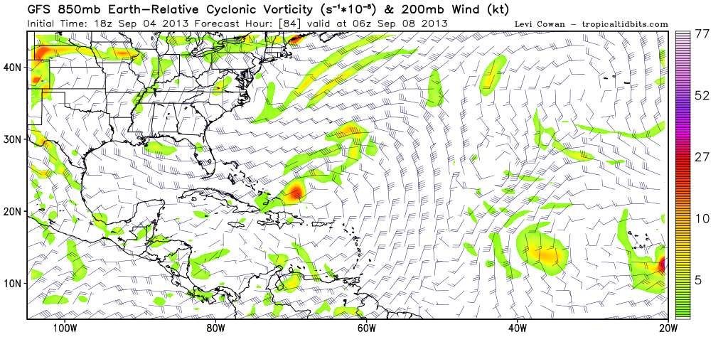
18Z vorticity has a different picture, showing TD7 as taking control.

Sharp recurves around 72 hours, moving NE at 84.

Image

Loop: http://www.tropicaltidbits.com/analysis/models/gfs/2013090418/gfs_vort850_uv200_atltropics.html
0 likes   
M a r k
- - - - -
Join us in chat: Storm2K Chatroom Invite. Android and IOS apps also available.

The posts in this forum are NOT official forecasts and should not be used as such. Posts are NOT endorsed by any professional institution or STORM2K.org. For official information and forecasts, please refer to NHC and NWS products.

User avatar
cycloneye
Admin
Admin
Posts: 139119
Age: 67
Joined: Thu Oct 10, 2002 10:54 am
Location: San Juan, Puerto Rico

Re: ATL: SEVEN - Models

#278 Postby cycloneye » Wed Sep 04, 2013 7:47 pm

CHGHUR
TROPICAL CYCLONE GUIDANCE MESSAGE
NWS NATIONAL HURRICANE CENTER MIAMI FL
0036 UTC THU SEP 5 2013

DISCLAIMER...NUMERICAL MODELS ARE SUBJECT TO LARGE ERRORS.
PLEASE REFER TO NHC OFFICIAL FORECASTS FOR TROPICAL CYCLONE
AND SUBTROPICAL CYCLONE INFORMATION.

ATLANTIC OBJECTIVE AIDS FOR

TROPICAL CYCLONE GABRIELLE (AL072013) 20130905 0000 UTC

...00 HRS... ...12 HRS... ...24 HRS... ...36 HRS...
130905 0000 130905 1200 130906 0000 130906 1200

LAT LON LAT LON LAT LON LAT LON
BAMS 16.7N 66.3W 17.8N 67.9W 18.9N 69.4W 19.6N 70.7W
BAMD 16.7N 66.3W 17.6N 67.5W 18.4N 68.5W 19.2N 69.4W
BAMM 16.7N 66.3W 17.7N 67.6W 18.5N 68.7W 19.1N 69.7W
LBAR 16.7N 66.3W 17.9N 67.6W 19.1N 68.9W 20.2N 70.1W
SHIP 35KTS 44KTS 51KTS 57KTS
DSHP 35KTS 44KTS 51KTS 57KTS

...48 HRS... ...72 HRS... ...96 HRS... ..120 HRS...
130907 0000 130908 0000 130909 0000 130910 0000

LAT LON LAT LON LAT LON LAT LON
BAMS 20.3N 71.8W 21.3N 73.2W 21.9N 73.7W 22.4N 74.3W
BAMD 19.9N 69.9W 21.9N 70.0W 24.9N 67.8W 28.8N 64.4W
BAMM 19.7N 70.5W 21.2N 71.3W 22.9N 70.7W 24.9N 69.2W
LBAR 21.1N 71.1W 23.4N 72.1W 25.7N 71.4W 27.0N 69.8W
SHIP 62KTS 68KTS 66KTS 62KTS
DSHP 62KTS 68KTS 66KTS 62KTS

...INITIAL CONDITIONS...
LATCUR = 16.7N LONCUR = 66.3W DIRCUR = 325DEG SPDCUR = 6KT
LATM12 = 15.8N LONM12 = 65.2W DIRM12 = 296DEG SPDM12 = 7KT
LATM24 = 15.4N LONM24 = 64.0W
WNDCUR = 35KT RMAXWD = 30NM WNDM12 = 25KT
CENPRS = 1008MB OUTPRS = 1010MB OUTRAD = 120NM SDEPTH = M
RD34NE = 40NM RD34SE = 0NM RD34SW = 0NM RD34NW = 0NM
0 likes   
Visit the Caribbean-Central America Weather Thread where you can find at first post web cams,radars
and observations from Caribbean basin members Click Here

User avatar
ROCK
Category 5
Category 5
Posts: 9254
Age: 53
Joined: Tue Aug 17, 2004 7:30 am
Location: Kemah, Texas

Re: ATL: SEVEN - Models

#279 Postby ROCK » Wed Sep 04, 2013 8:53 pm

18Z NAVGEM develops the NE low and traps Gabby north of Hispa....fun times...

http://www.tropicaltidbits.com/analysis/models/navgem/2013090418/
0 likes   

User avatar
ROCK
Category 5
Category 5
Posts: 9254
Age: 53
Joined: Tue Aug 17, 2004 7:30 am
Location: Kemah, Texas

Re: ATL: GABRIELLE - Models

#280 Postby ROCK » Wed Sep 04, 2013 9:58 pm

0Z NAM.....develops the NE blob and leaves behind whats left of Gabby....

http://www.tropicaltidbits.com/analysis/models/nam/2013090500/nam_reflectivity_watl.html
0 likes   


Return to “2013”

Who is online

Users browsing this forum: No registered users and 47 guests