ATL: INGRID - Models
Moderator: S2k Moderators
-
South Texas Storms

- Professional-Met

- Posts: 4014
- Joined: Thu Jun 24, 2010 12:28 am
- Location: Houston, TX
-
cycloneye

- Admin

- Posts: 139173
- Age: 67
- Joined: Thu Oct 10, 2002 10:54 am
- Location: San Juan, Puerto Rico
Re: ATL: INVEST 93L - Models
First plots.
WHXX01 KWBC 101522
CHGHUR
TROPICAL CYCLONE GUIDANCE MESSAGE
NWS NATIONAL HURRICANE CENTER MIAMI FL
1522 UTC TUE SEP 10 2013
DISCLAIMER...NUMERICAL MODELS ARE SUBJECT TO LARGE ERRORS.
PLEASE REFER TO NHC OFFICIAL FORECASTS FOR TROPICAL CYCLONE
AND SUBTROPICAL CYCLONE INFORMATION.
ATLANTIC OBJECTIVE AIDS FOR
DISTURBANCE INVEST (AL932013) 20130910 1200 UTC
...00 HRS... ...12 HRS... ...24 HRS... ...36 HRS...
130910 1200 130911 0000 130911 1200 130912 0000
LAT LON LAT LON LAT LON LAT LON
BAMS 18.0N 86.0W 18.7N 87.8W 19.3N 89.9W 19.8N 91.8W
BAMD 18.0N 86.0W 18.3N 87.3W 18.8N 88.8W 19.3N 90.3W
BAMM 18.0N 86.0W 18.5N 87.6W 19.0N 89.3W 19.5N 91.1W
LBAR 18.0N 86.0W 18.4N 87.4W 19.2N 89.3W 20.3N 91.2W
SHIP 20KTS 24KTS 30KTS 38KTS
DSHP 20KTS 22KTS 25KTS 31KTS
...48 HRS... ...72 HRS... ...96 HRS... ..120 HRS...
130912 1200 130913 1200 130914 1200 130915 1200
LAT LON LAT LON LAT LON LAT LON
BAMS 20.0N 93.8W 19.8N 97.2W 19.2N 100.1W 18.7N 102.2W
BAMD 19.8N 91.8W 20.5N 94.3W 21.1N 96.7W 21.8N 99.3W
BAMM 19.9N 93.0W 20.0N 96.1W 19.8N 99.0W 19.5N 101.2W
LBAR 21.5N 92.9W 23.9N 95.6W 26.1N 96.9W 28.3N 97.3W
SHIP 46KTS 59KTS 67KTS 71KTS
DSHP 39KTS 52KTS 30KTS 27KTS
...INITIAL CONDITIONS...
LATCUR = 18.0N LONCUR = 86.0W DIRCUR = 280DEG SPDCUR = 6KT
LATM12 = 17.9N LONM12 = 84.7W DIRM12 = 286DEG SPDM12 = 5KT
LATM24 = 17.4N LONM24 = 83.9W
WNDCUR = 20KT RMAXWD = 50NM WNDM12 = 20KT
CENPRS = 1009MB OUTPRS = 1010MB OUTRAD = 100NM SDEPTH = S
RD34NE = 0NM RD34SE = 0NM RD34SW = 0NM RD34NW = 0NM
0 likes
Visit the Caribbean-Central America Weather Thread where you can find at first post web cams,radars
and observations from Caribbean basin members Click Here
and observations from Caribbean basin members Click Here

-
cycloneye
- Admin
- Posts: 139173
- Age: 67
- Joined: Thu Oct 10, 2002 10:54 am
- Location: San Juan, Puerto Rico
Re: ATL: INVEST 93L - Models
12z GFS at 87 hours.

0 likes
Visit the Caribbean-Central America Weather Thread where you can find at first post web cams,radars
and observations from Caribbean basin members Click Here
and observations from Caribbean basin members Click Here
-
tolakram
- Admin
- Posts: 19165
- Age: 60
- Joined: Sun Aug 27, 2006 8:23 pm
- Location: Florence, KY (name is Mark)
Re: ATL: INVEST 93L - Models
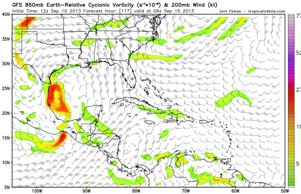
12Z GFS vorticity pretty spread out.
0 likes
M a r k
- - - - -
Join us in chat: Storm2K Chatroom Invite. Android and IOS apps also available.
The posts in this forum are NOT official forecasts and should not be used as such. Posts are NOT endorsed by any professional institution or STORM2K.org. For official information and forecasts, please refer to NHC and NWS products.
Re: ATL: INVEST 93L - Models
12Z hitting Brownsville.... from the south...also the ridge folds up to open up the coast...
http://www.tropicaltidbits.com/analysis ... atl_44.png
http://www.tropicaltidbits.com/analysis ... atl_44.png
http://www.tropicaltidbits.com/analysis ... atl_44.png
http://www.tropicaltidbits.com/analysis ... atl_44.png
http://www.tropicaltidbits.com/analysis ... atl_44.png
http://www.tropicaltidbits.com/analysis ... atl_44.png
0 likes
-
Rgv20

- S2K Supporter

- Posts: 2456
- Age: 37
- Joined: Wed Jan 05, 2011 5:42 pm
- Location: Edinburg/McAllen Tx
Landfall just south of Brownsville by Sunday Evening.....Heavy rains spreading to much of Texas! 

Uploaded with ImageShack.us

Uploaded with ImageShack.us
0 likes
The following post is NOT an official forecast and should not be used as such. It is just the opinion of the poster and may or may not be backed by sound meteorological data. It is NOT endorsed by any professional institution including storm2k.org For Official Information please refer to the NHC and NWS products.
-
Rgv20
- S2K Supporter
- Posts: 2456
- Age: 37
- Joined: Wed Jan 05, 2011 5:42 pm
- Location: Edinburg/McAllen Tx
Re: ATL: INVEST 93L - Models
tolakram wrote:12Z GFS vorticity pretty spread out.
[img]http://img198.imageshack.us/img198/6008/v4wz.jpg
This maybe the case where such a big and broad area of low pressure has trouble consolidating...On the flip side this would mean a pretty big and wet system, good news for us in Texas.
0 likes
The following post is NOT an official forecast and should not be used as such. It is just the opinion of the poster and may or may not be backed by sound meteorological data. It is NOT endorsed by any professional institution including storm2k.org For Official Information please refer to the NHC and NWS products.
-
Portastorm

- Storm2k Moderator

- Posts: 9787
- Age: 61
- Joined: Fri Jul 11, 2003 9:16 am
- Location: South Austin, TX
- Contact:
Re: ATL: INVEST 93L - Models
Rgv20 wrote:tolakram wrote:12Z GFS vorticity pretty spread out.
[img]http://img198.imageshack.us/img198/6008/v4wz.jpg
This maybe the case where such a big and broad area of low pressure has trouble consolidating...On the flip side this would mean a pretty big and wet system, good news for us in Texas.
Definitely a possibility ... a large, slop-gyre type system. That may be the best for us in Texas in providing generous rains without the damaging wind part.
0 likes
Any forecasts under my name are to be taken with a grain of salt. Get your best forecasts from the National Weather Service and National Hurricane Center.
I'm a certified Advanced SKYWARN-trained spotter and am active on Twitter at @TravisCOSW, a social media partner of the NWS Austin-San Antonio office.
I'm a certified Advanced SKYWARN-trained spotter and am active on Twitter at @TravisCOSW, a social media partner of the NWS Austin-San Antonio office.
-
South Texas Storms
- Professional-Met
- Posts: 4014
- Joined: Thu Jun 24, 2010 12:28 am
- Location: Houston, TX
Re: ATL: INVEST 93L - Models
Here is a look at the 12z GFS forecast for total precipitation through the next 7 days:

Uploaded with ImageShack.us

Uploaded with ImageShack.us
0 likes
-
PTrackerLA

- Category 5

- Posts: 5248
- Age: 40
- Joined: Thu Oct 10, 2002 8:40 pm
- Location: Lafayette, LA
Re: ATL: INVEST 93L - Models
0 likes

Re: ATL: INVEST 93L - Models
ROCK wrote::uarrow: might be a large Hurricane...if the conditions aloft are right...potential is there...
Interesting you mention a large hurricane. They take longer to intensify, but they are capable of rapid intensification. Think Katrina.
I would not rule out Texas getting hit by this storm. Most models have not been good with where the storms go.
0 likes
-
HouTXmetro

- Category 5
- Posts: 3949
- Joined: Sun Jun 13, 2004 6:00 pm
- Location: District of Columbia, USA
I'm shocked that the GFS is showing South Texas. I was thinking Mexico. Rock, you mentioned "the ridge folding to open up the coast". Any possibility this could make it's way even further up let's say Corpus area?
0 likes
[Disclaimer: My Amateur Opinion, please defer to your local authorities or the NHC for Guidance.]
Re: ATL: INVEST 93L - Models
120hr NAVGEM....more north than before...a VERY large system...
http://www.tropicaltidbits.com/analysis ... atl_21.png
http://www.tropicaltidbits.com/analysis ... atl_21.png
0 likes

Re: ATL: INVEST 93L - Models
bigger than IKE?? holy crap....
http://www.tropicaltidbits.com/analysis ... atl_25.png

Uploaded with ImageShack.us
http://www.tropicaltidbits.com/analysis ... atl_25.png

Uploaded with ImageShack.us
0 likes
Re: ATL: INVEST 93L - Models
LA folks? might want to call your NWS office in NO.... 
NAVGEM now in Central GOM...takes up the entire GOM
http://www.tropicaltidbits.com/analysis ... atl_27.png
NAVGEM now in Central GOM...takes up the entire GOM
http://www.tropicaltidbits.com/analysis ... atl_27.png
0 likes
-
lester

- S2K Supporter
- Posts: 1305
- Age: 35
- Joined: Sat Aug 27, 2005 5:21 pm
- Location: Washington, DC
- Contact:
Re: ATL: INVEST 93L - Models
ROCK wrote:bigger than IKE?? holy ***....
http://www.tropicaltidbits.com/analysis ... atl_25.png
Uploaded with ImageShack.us
Wow

0 likes
Re: ATL: INVEST 93L - Models
NAVGEM says ridge? what ridge?
maybe just maybe some NGOMERS will take notice...
maybe just maybe some NGOMERS will take notice...
Last edited by ROCK on Tue Sep 10, 2013 12:13 pm, edited 1 time in total.
0 likes
Who is online
Users browsing this forum: No registered users and 64 guests