ATL: INVEST 95L - Models

Moderator: S2k Moderators

Message
Author
caneman

Re: ATL: INVEST 95L - Models

#161 Postby caneman » Wed Sep 18, 2013 11:23 am

blp wrote:
caneman wrote:
Agreed Blown Away on October pattern possibly more likely. Not real sure about the map provided but I remember Gabrielle well coming off the tip of the Yucatan and hitting us around the same time as 9/11 from 2001. The last Major to hit the Tampa area was from that very same area. Not saying it will be a major but anything coming from South and West of us always gets my attention.


The 1921 major hurricane that hit Tampa orginated in the W. Carribean and was from 20-30 OCT. Gabrielle in 2001 formed in the Eastern Gulf just off the West coast of Florida. Yes if you include October then the probabilities increase. I not saying it could not happen since we have seen stranger things before, it's just that it would be a historic first with regards to the climatological record.


Not really. Although Gabrielle wasn't classified until the Eastern Gulf it did come off the North or NW tip Yucatan. Tropical Storm Gordon (2000) is another that came of the Yucatan to affect us and points North. I'm sure there have been others. Having lived hear for so long, I would know. I've never bought much into the climatological thing much anyway (other than in a general sense), Mother Nature doesn't have a memory of where storms are supposed to form and which way they should go.
0 likes   

User avatar
PTrackerLA
Category 5
Category 5
Posts: 5248
Age: 40
Joined: Thu Oct 10, 2002 8:40 pm
Location: Lafayette, LA

Re: ATL: INVEST 95L - Models

#162 Postby PTrackerLA » Wed Sep 18, 2013 12:08 pm

12z GFS seems to just leave 95L in the BOC after missing the trough. Doesn't really intensify it though.
0 likes   

User avatar
Ptarmigan
Category 5
Category 5
Posts: 5273
Joined: Wed Aug 16, 2006 9:06 pm

Re: ATL: INVEST 95L - Models

#163 Postby Ptarmigan » Wed Sep 18, 2013 12:09 pm

cycloneye wrote:http://oi41.tinypic.com/2e395ya.jpg

http://oi40.tinypic.com/a2b3v4.jpg


When I see the models split on where it goes, it is a low confidence forecast. Could go anywhere from Mexico to Florida.
0 likes   

User avatar
ROCK
Category 5
Category 5
Posts: 9254
Age: 52
Joined: Tue Aug 17, 2004 7:30 am
Location: Kemah, Texas

Re: ATL: INVEST 95L - Models

#164 Postby ROCK » Wed Sep 18, 2013 12:30 pm

all the 12Z global runs looked to have dropped anything of significance coming from 95L. Now they are leaving it in the BOC and then stringing out lows in the front towards the NE....

waiting on EURO to confirm....
0 likes   

User avatar
blp
Category 5
Category 5
Posts: 2805
Age: 45
Joined: Thu Sep 09, 2004 7:51 pm
Location: Miami, FL
Contact:

Re: ATL: INVEST 95L - Models

#165 Postby blp » Wed Sep 18, 2013 12:37 pm

caneman wrote:
blp wrote:
Not really. Although Gabrielle wasn't classified until the Eastern Gulf it did come off the North or NW tip Yucatan. Tropical Storm Gordon (2000) is another that came of the Yucatan to affect us and points North. I'm sure there have been others. Having lived hear for so long, I would know. I've never bought much into the climatological thing much anyway (other than in a general sense), Mother Nature doesn't have a memory of where storms are supposed to form and which way they should go.


Gordon in 2000 formed on the NE tip of the Yucatan. I think you missed the point of my original post. The point of the graphic was to try to find a specific examples of a systems that developed (classified) in the BOC and where they made landfall in September. In the case of Central or Southern Florida I could not find one example in the track database. So if you find a specific example please let me know.
0 likes   
The following post is NOT an official forecast and should not be used as such. It is just the opinion of the poster and may or may not be backed by sound meteorological data. It is NOT endorsed by any professional institution including storm2k.org For Official Information please refer to the NHC and NWS products.

tolakram
Admin
Admin
Posts: 19165
Age: 60
Joined: Sun Aug 27, 2006 8:23 pm
Location: Florence, KY (name is Mark)

Re: ATL: INVEST 95L - Models

#166 Postby tolakram » Wed Sep 18, 2013 1:05 pm

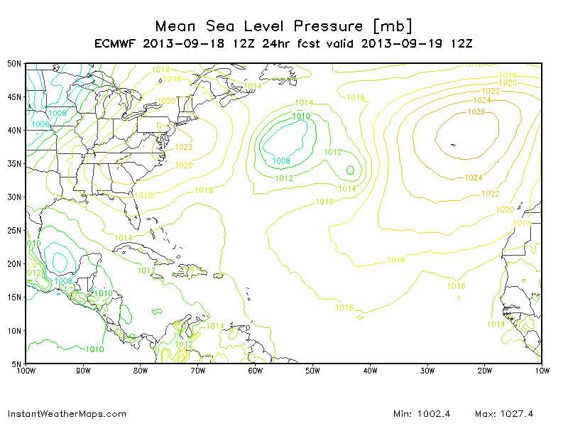
12Z Euro

48 hours, emerges from the western side of the peninsula moving NW.

Image

http://www.instantweathermaps.com/ECMWF-php/showmap-ecmwf.php?run=2013091812&region=NATL&var=PRMSL_msl&hour=024
0 likes   
M a r k
- - - - -
Join us in chat: Storm2K Chatroom Invite. Android and IOS apps also available.

The posts in this forum are NOT official forecasts and should not be used as such. Posts are NOT endorsed by any professional institution or STORM2K.org. For official information and forecasts, please refer to NHC and NWS products.

tolakram
Admin
Admin
Posts: 19165
Age: 60
Joined: Sun Aug 27, 2006 8:23 pm
Location: Florence, KY (name is Mark)

Re: ATL: INVEST 95L - Models

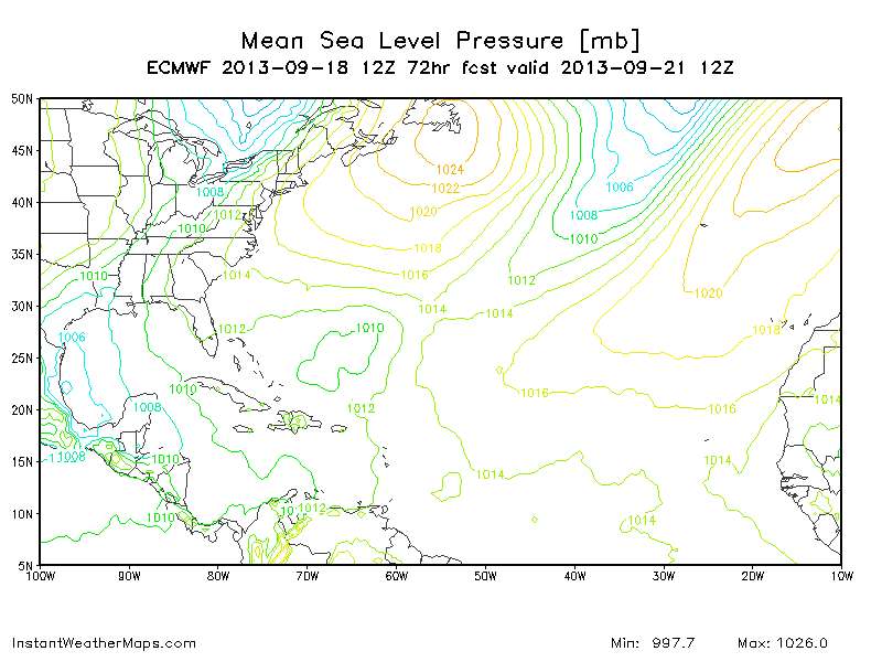
#167 Postby tolakram » Wed Sep 18, 2013 1:08 pm

72 hours, just offshore. This is nearly due west from 48h position.

Image
0 likes   
M a r k
- - - - -
Join us in chat: Storm2K Chatroom Invite. Android and IOS apps also available.

The posts in this forum are NOT official forecasts and should not be used as such. Posts are NOT endorsed by any professional institution or STORM2K.org. For official information and forecasts, please refer to NHC and NWS products.

User avatar
tropicwatch
Category 5
Category 5
Posts: 3205
Age: 60
Joined: Sat Jun 02, 2007 10:01 am
Location: Panama City Florida
Contact:

Re: ATL: INVEST 95L - Models

#168 Postby tropicwatch » Wed Sep 18, 2013 1:11 pm

tolakram wrote:12Z Euro

48 hours, emerges from the western side of the peninsula moving NW.

Image

http://www.instantweathermaps.com/ECMWF-php/showmap-ecmwf.php?run=2013091812&region=NATL&var=PRMSL_msl&hour=024


Can't we disregard that run since it is already entering the BOC?
0 likes   
Tropicwatch


Agnes 72', Eloise 75, Elena 85', Kate 85', Charley 86', Florence 88', Beryl 94', Dean 95', Erin 95', Opal 95', Earl 98', Georges 98', Ivan 2004', Arlene 2005', Dennis 2005', Ida 2009' Debby 2012' Irma 2017' Michael 2018'

tolakram
Admin
Admin
Posts: 19165
Age: 60
Joined: Sun Aug 27, 2006 8:23 pm
Location: Florence, KY (name is Mark)

Re: ATL: INVEST 95L - Models

#169 Postby tolakram » Wed Sep 18, 2013 1:14 pm

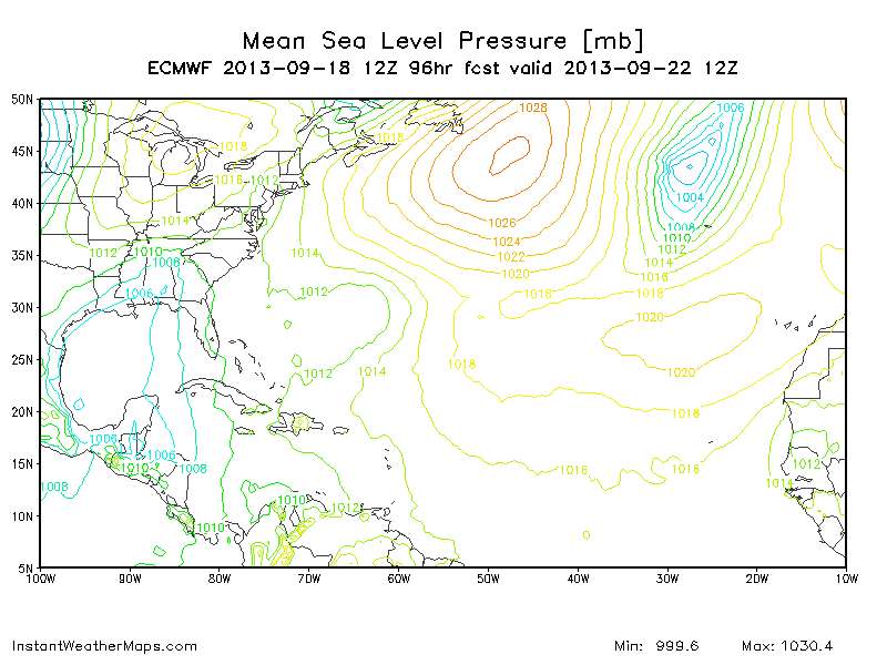
I think the initialization was pretty good.

96 hours, the vorticity map shows a slow SW movement from the previous position, still offshore. This map appears to move it S or S/SE.

Image
0 likes   
M a r k
- - - - -
Join us in chat: Storm2K Chatroom Invite. Android and IOS apps also available.

The posts in this forum are NOT official forecasts and should not be used as such. Posts are NOT endorsed by any professional institution or STORM2K.org. For official information and forecasts, please refer to NHC and NWS products.

caneman

Re: ATL: INVEST 95L - Models

#170 Postby caneman » Wed Sep 18, 2013 1:17 pm

I get your point blp and appeciate it.. My point is simply that we get affected quit a bit from that general area in Sept. I know your post is for storms that come from the BOC but my point is that it doesn't really matter, many years you have storms that pop up in areas that weren't expected or aren't climatologically favored. This would only be perhaps 50 - 100 miles west of a couple of the storms I mentioned. Every year is different. When is the last time you had so many storms form in the BOC? Anywho. back on topic.
0 likes   

User avatar
TreasureIslandFLGal
S2K Supporter
S2K Supporter
Posts: 1558
Age: 56
Joined: Sun Aug 15, 2004 6:16 pm
Location: Clearwater, Florida ~3 miles from the coast now. We finally moved safely off the barrier island!

#171 Postby TreasureIslandFLGal » Wed Sep 18, 2013 1:19 pm

with the circulation now off the coast, I suspect tonight's runs will actually have something to work with. I'm sure a lot of soundings are being taken to try and assess that approaching front too. let's see what the models are saying tomorrow morning.
already, based on where the center has emerged...which model had that correct?? location and timing? any of them??
0 likes   
Chrissy & Ligeia
Chrissy & Nikki
:flag:

User avatar
ROCK
Category 5
Category 5
Posts: 9254
Age: 52
Joined: Tue Aug 17, 2004 7:30 am
Location: Kemah, Texas

Re: ATL: INVEST 95L - Models

#172 Postby ROCK » Wed Sep 18, 2013 1:21 pm

not much to look at...strung out in the front now....rainmaker for the NE GOM...
0 likes   

tolakram
Admin
Admin
Posts: 19165
Age: 60
Joined: Sun Aug 27, 2006 8:23 pm
Location: Florence, KY (name is Mark)

Re: ATL: INVEST 95L - Models

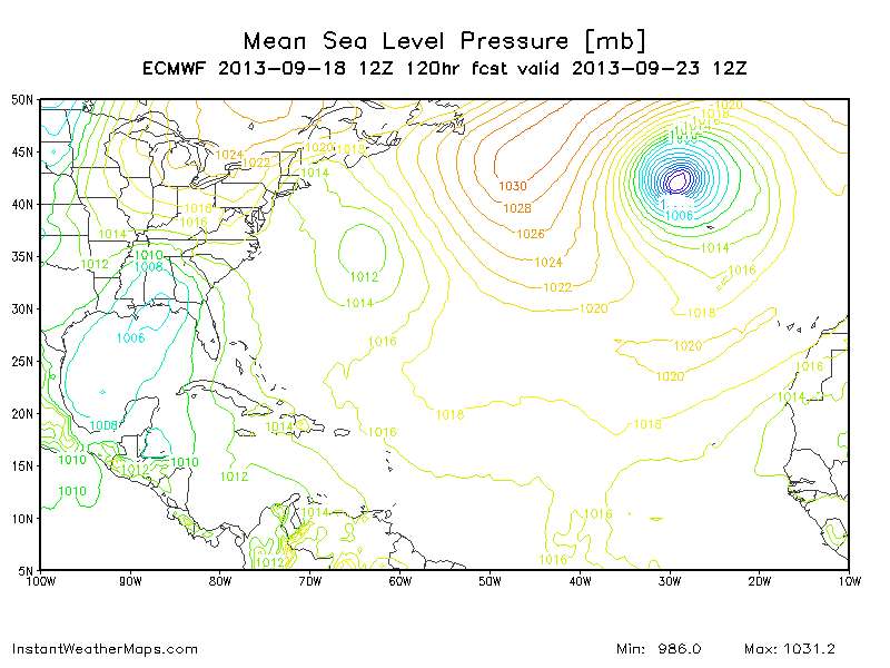
#173 Postby tolakram » Wed Sep 18, 2013 1:22 pm

Bouncing back east, weaker. This looks to me like it develops, gets near the coast, and gets ripped apart.

Personal Forecast Disclaimer:
The posts in this forum are NOT official forecast and should not be used as such. They are just the opinion of the poster and may or may not be backed by sound meteorological data. They are NOT endorsed by any professional institution or storm2k.org. For official information, please refer to the NHC and NWS products.

Image
0 likes   
M a r k
- - - - -
Join us in chat: Storm2K Chatroom Invite. Android and IOS apps also available.

The posts in this forum are NOT official forecasts and should not be used as such. Posts are NOT endorsed by any professional institution or STORM2K.org. For official information and forecasts, please refer to NHC and NWS products.

User avatar
Blown Away
S2K Supporter
S2K Supporter
Posts: 9863
Joined: Wed May 26, 2004 6:17 am

Re: ATL: INVEST 95L - Models

#174 Postby Blown Away » Wed Sep 18, 2013 1:27 pm

:uarrow: It's still there, it's that little pimple in the BOC... :lol:
0 likes   
Hurricane Eye Experience: David 79, Irene 99, Frances 04, Jeanne 04, Wilma 05...
Hurricane Brush Experience: Andrew 92, Erin 95, Floyd 99, Matthew 16, Irma 17, Ian 22, Nicole 22…

tolakram
Admin
Admin
Posts: 19165
Age: 60
Joined: Sun Aug 27, 2006 8:23 pm
Location: Florence, KY (name is Mark)

Re: ATL: INVEST 95L - Models

#175 Postby tolakram » Wed Sep 18, 2013 1:29 pm

Blown Away wrote::uarrow: It's still there, it's that little pimple in the BOC... :lol:


But looking at the vorticity map the center is way south of the lowest pressure. We've quickly gone beyond my model reading skill. :) I'm looking at the GFS shear forecast for the same time period and it shows good conditions.
0 likes   
M a r k
- - - - -
Join us in chat: Storm2K Chatroom Invite. Android and IOS apps also available.

The posts in this forum are NOT official forecasts and should not be used as such. Posts are NOT endorsed by any professional institution or STORM2K.org. For official information and forecasts, please refer to NHC and NWS products.

tolakram
Admin
Admin
Posts: 19165
Age: 60
Joined: Sun Aug 27, 2006 8:23 pm
Location: Florence, KY (name is Mark)

Re: ATL: INVEST 95L - Models

#176 Postby tolakram » Wed Sep 18, 2013 1:56 pm

The 12Z run seems bad, but I guess it could happen. The system is basically gone at 192H, stretched and reduced to nothing after wandering back and forth in the BOC.
0 likes   
M a r k
- - - - -
Join us in chat: Storm2K Chatroom Invite. Android and IOS apps also available.

The posts in this forum are NOT official forecasts and should not be used as such. Posts are NOT endorsed by any professional institution or STORM2K.org. For official information and forecasts, please refer to NHC and NWS products.

CYCLONE MIKE
Category 5
Category 5
Posts: 2183
Joined: Tue Aug 31, 2004 6:04 pm
Location: Gonzales, LA

Re: ATL: INVEST 95L - Models

#177 Postby CYCLONE MIKE » Wed Sep 18, 2013 2:43 pm

Welcome to hurricane season 2013 :roll:

Before writing it off completely will see what tonights runs show and if its still the same think its pretty much a done deal. Hopefully we can at least get some rain out of this invest unlike the last one.
0 likes   
This post is NOT AN OFFICIAL FORECAST and should not be used as such. It is just the opinion of the poster and may or may not be backed by sound meteorological data. It is NOT endorsed by any professional institution including storm2k.org. For Official Information please refer to the NHC and NWS products.

Stormcenter
S2K Supporter
S2K Supporter
Posts: 6617
Joined: Wed Sep 03, 2003 11:27 am
Location: Houston, TX

Re: ATL: INVEST 95L - Models

#178 Postby Stormcenter » Wed Sep 18, 2013 2:47 pm

Done deal...based on a model runs?

CYCLONE MIKE wrote:Welcome to hurricane season 2013 :roll:

Before writing it off completely will see what tonights runs show and if its still the same think its pretty much a done deal. Hopefully we can at least get some rain out of this invest unlike the last one.
0 likes   

Ntxw
Storm2k Moderator
Storm2k Moderator
Posts: 21511
Joined: Wed Oct 21, 2009 6:34 pm
Location: DFW, Texas

#179 Postby Ntxw » Wed Sep 18, 2013 2:50 pm

Whatever it does between now and then, most models do agree it will be blasted/effected by wall of shear this weekend associated with the front/trof in the northern and NW gulf. It will get bullied if it doesn't get its act together fast if the pattern on the models are correct.
0 likes   
The above post and any post by Ntxw is NOT an official forecast and should not be used as such. It is just the opinion of the poster and may or may not be backed by sound meteorological data. It is NOT endorsed by any professional institution including Storm2k. For official information, please refer to NWS products.

  Help support Storm2K!
Help Support Storm2K

User avatar
tailgater
S2K Supporter
S2K Supporter
Posts: 3339
Joined: Sun Jul 11, 2004 9:13 pm
Location: St. Amant La.

Re: ATL: INVEST 95L - Models

#180 Postby tailgater » Wed Sep 18, 2013 2:52 pm

Love the way so many S2Kers live and die by each of these model runs, IMHO we'll talking about a possible hurricane tomorrow and no I'm not saying it will be a hurricane tomorrow.
0 likes   
The following post is NOT an official forecast and should not be used as such. It is just the opinion of the poster and may or may not be backed by sound meteorological data. It is NOT endorsed by any professional institution including storm2k.org For Official Information please refer to the NHC and NWS products.


Return to “2013”

Who is online

Users browsing this forum: No registered users and 106 guests