ATL: KAREN - Models
Moderator: S2k Moderators

Re: ATL: KAREN - Models
"The trend is your friend', and the fact is, the Euro has now trended eastward towards the GFS, not the other way around. If the official track forecast is a blend of the two, it only seems logical that further eastward adjustments will be made by the NHC, assuming the Euro continues or maintains it's eastward solution.
0 likes
-
stormlover2013
- Category 5

- Posts: 2312
- Joined: Thu Aug 22, 2013 12:06 pm
- Location: Lumberton, Texas
Re: ATL: KAREN - Models
Euro has been showing LA whole time for first landfall and gfs has been showing only FL!!!
I am sure if euro was showing Florida and GFS showing la you would be all over the EURO also lol front runner!!! just joking around with you my man!!! hey are you on warchant.com?
I am sure if euro was showing Florida and GFS showing la you would be all over the EURO also lol front runner!!! just joking around with you my man!!! hey are you on warchant.com?
0 likes
-
Evil Jeremy

- S2K Supporter

- Posts: 5459
- Age: 30
- Joined: Mon Apr 10, 2006 2:10 pm
- Location: Los Angeles, CA
From the 11am Discussion:
THE NOAA GULFSTREAM-IV JET SAMPLED THE ENVIRONMENT NEAR KAREN AND
OVER THE NORTHERN GULF OF MEXICO OVERNIGHT. THESE DATA WILL BE
INCORPORATED INTO THE 12Z MODEL CYCLE...AND HOPEFULLY IMPROVE THE
ANALYSIS OF THE ENVIRONMENT NEAR AND AHEAD OF THE STORM.
I'm looking forward to the GIV models! Hopefully it will clear up that spread from Louisiana to Florida.
0 likes
Frances 04 / Jeanne 04 / Katrina 05 / Wilma 05 / Fay 08 / Debby 12 / Andrea 13 / Colin 16 / Hermine 16 / Matthew 16 / Irma 17
Re: ATL: KAREN - Models
Hey stormlover, nah man! I don't WANT it over this way, I've got a football game to go to tomorrow!
Yep, that's me over on Warchant.
Yep, that's me over on Warchant.
0 likes
-
stormlover2013
- Category 5
- Posts: 2312
- Joined: Thu Aug 22, 2013 12:06 pm
- Location: Lumberton, Texas
-
tolakram
- Admin

- Posts: 19165
- Age: 60
- Joined: Sun Aug 27, 2006 8:23 pm
- Location: Florence, KY (name is Mark)
Re: ATL: KAREN - Models
stormlover2013 wrote:Euro has been showing LA whole time for first landfall and gfs has been showing only FL!!!
I am sure if euro was showing Florida and GFS showing la you would be all over the EURO also lol front runner!!! just joking around with you my man!!! hey are you on warchant.com?
Go back 5 days. GFS originally showed central LA, then switched to Florida when it started to develop a system east of where Karen formed. This is why the analysis that Karen might reform to the east is an interesting one, and one that would bust the current Euro solution. It might be because the GFS can predict cyclogenesis better than the Euro, it might be because GFS overplays these kinds of situations. Something to keep an eye on anyways.
0 likes
M a r k
- - - - -
Join us in chat: Storm2K Chatroom Invite. Android and IOS apps also available.
The posts in this forum are NOT official forecasts and should not be used as such. Posts are NOT endorsed by any professional institution or STORM2K.org. For official information and forecasts, please refer to NHC and NWS products.
-
tolakram
- Admin
- Posts: 19165
- Age: 60
- Joined: Sun Aug 27, 2006 8:23 pm
- Location: Florence, KY (name is Mark)
Re: ATL: KAREN - Models
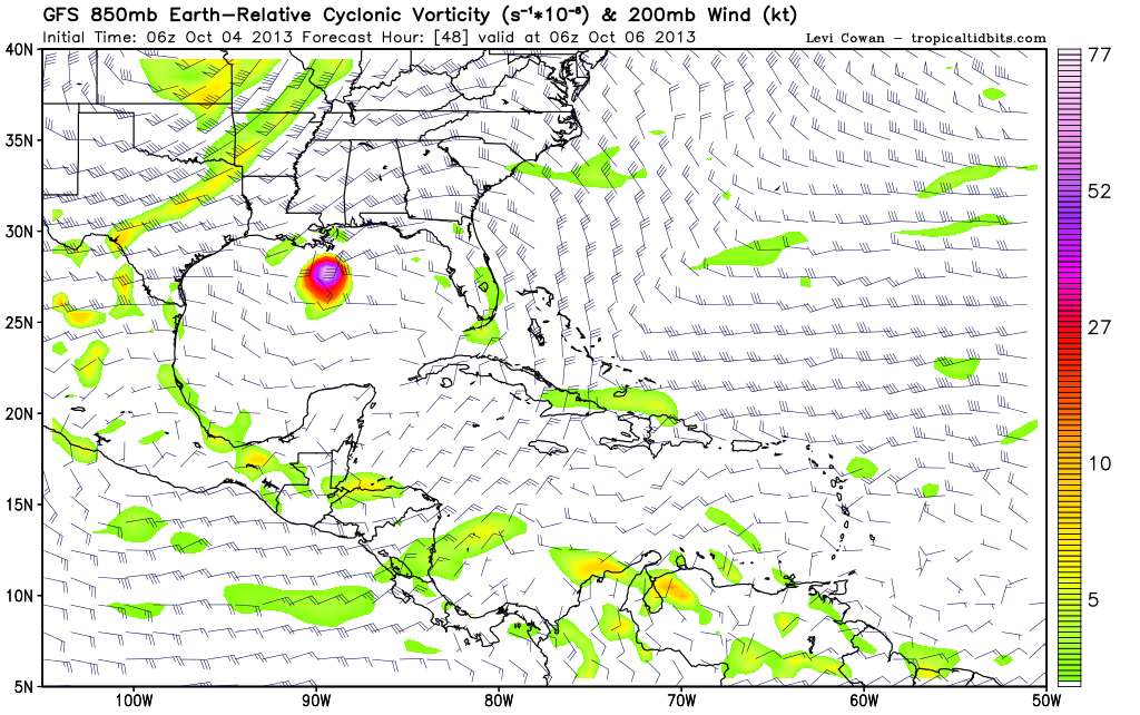
Just to review the latest GFS solution.
In 24 hours the vorticity signature is pretty bad.
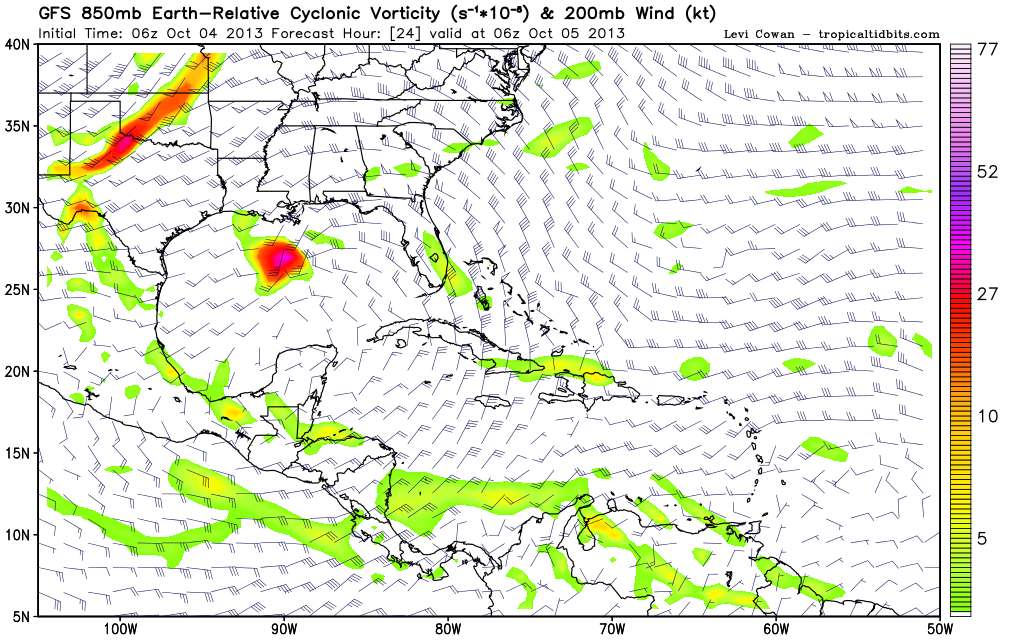
In 48 hours a remarkable recovery and movement to the E/NE. So it's not really a bend to the east it's more like a reorganization and then moving east.
In 24 hours the vorticity signature is pretty bad.
In 48 hours a remarkable recovery and movement to the E/NE. So it's not really a bend to the east it's more like a reorganization and then moving east.
0 likes
M a r k
- - - - -
Join us in chat: Storm2K Chatroom Invite. Android and IOS apps also available.
The posts in this forum are NOT official forecasts and should not be used as such. Posts are NOT endorsed by any professional institution or STORM2K.org. For official information and forecasts, please refer to NHC and NWS products.
- - - - -
Join us in chat: Storm2K Chatroom Invite. Android and IOS apps also available.
The posts in this forum are NOT official forecasts and should not be used as such. Posts are NOT endorsed by any professional institution or STORM2K.org. For official information and forecasts, please refer to NHC and NWS products.

Re: ATL: KAREN - Models
N2FSU wrote:"The trend is your friend', and the fact is, the Euro has now trended eastward towards the GFS, not the other way around. If the official track forecast is a blend of the two, it only seems logical that further eastward adjustments will be made by the NHC, assuming the Euro continues or maintains it's eastward solution.
actually the 06Z GFS trended towards LA more so than the 0Z...it hooks it E before it makes it to the coast. The EURO actually makes it to the coast before moving east.
the NHC just shifted their track left some...
0 likes
-
Aric Dunn
- Category 5
- Posts: 21228
- Age: 41
- Joined: Sun Sep 19, 2004 9:58 pm
- Location: Ready for the Chase.
- Contact:
about that time for the new data in to the GFS lets see what happens.. GFS is running
0 likes
Note: If I make a post that is brief. Please refer back to previous posts for the analysis or reasoning. I do not re-write/qoute what my initial post said each time.
If there is nothing before... then just ask
Space & Atmospheric Physicist, Embry-Riddle Aeronautical University,
I believe the sky is falling...
If there is nothing before... then just ask
Space & Atmospheric Physicist, Embry-Riddle Aeronautical University,
I believe the sky is falling...
-
Aric Dunn
- Category 5
- Posts: 21228
- Age: 41
- Joined: Sun Sep 19, 2004 9:58 pm
- Location: Ready for the Chase.
- Contact:
hey I bet I know what the GFS is going to stick with..
its the nam but it does well with large scale.. ( also the nam had the euro solution the whole time till the new data) it heads straight east..
http://mag.ncep.noaa.gov/model-guidance ... mageSize=M
its the nam but it does well with large scale.. ( also the nam had the euro solution the whole time till the new data) it heads straight east..
http://mag.ncep.noaa.gov/model-guidance ... mageSize=M
0 likes
Note: If I make a post that is brief. Please refer back to previous posts for the analysis or reasoning. I do not re-write/qoute what my initial post said each time.
If there is nothing before... then just ask
Space & Atmospheric Physicist, Embry-Riddle Aeronautical University,
I believe the sky is falling...
If there is nothing before... then just ask
Space & Atmospheric Physicist, Embry-Riddle Aeronautical University,
I believe the sky is falling...
-
Aric Dunn
- Category 5
- Posts: 21228
- Age: 41
- Joined: Sun Sep 19, 2004 9:58 pm
- Location: Ready for the Chase.
- Contact:
GFS weaker this run and thus has shifted a little in the short term..
0 likes
Note: If I make a post that is brief. Please refer back to previous posts for the analysis or reasoning. I do not re-write/qoute what my initial post said each time.
If there is nothing before... then just ask
Space & Atmospheric Physicist, Embry-Riddle Aeronautical University,
I believe the sky is falling...
If there is nothing before... then just ask
Space & Atmospheric Physicist, Embry-Riddle Aeronautical University,
I believe the sky is falling...
-
Aric Dunn
- Category 5
- Posts: 21228
- Age: 41
- Joined: Sun Sep 19, 2004 9:58 pm
- Location: Ready for the Chase.
- Contact:
yep just like the 6z run turns due east almost.. south of the LA coast
lets see if the other models follow suit.
lets see if the other models follow suit.
0 likes
Note: If I make a post that is brief. Please refer back to previous posts for the analysis or reasoning. I do not re-write/qoute what my initial post said each time.
If there is nothing before... then just ask
Space & Atmospheric Physicist, Embry-Riddle Aeronautical University,
I believe the sky is falling...
If there is nothing before... then just ask
Space & Atmospheric Physicist, Embry-Riddle Aeronautical University,
I believe the sky is falling...
Re: ATL: KAREN - Models
So 12z GFS moves it a bit more north, stalls, shoots east then makes landfall around Panama City around 64 hours from the start time?
0 likes
-
stormlover2013
- Category 5
- Posts: 2312
- Joined: Thu Aug 22, 2013 12:06 pm
- Location: Lumberton, Texas
-
Aric Dunn
- Category 5
- Posts: 21228
- Age: 41
- Joined: Sun Sep 19, 2004 9:58 pm
- Location: Ready for the Chase.
- Contact:
Re: ATL: KAREN - Models
BobHarlem wrote:So 12z GFS moves it a bit more north, stalls, shoots east then makes landfall around Panama City around 64 hours from the start time?
pretty much like the 6z only weaker.
0 likes
Note: If I make a post that is brief. Please refer back to previous posts for the analysis or reasoning. I do not re-write/qoute what my initial post said each time.
If there is nothing before... then just ask
Space & Atmospheric Physicist, Embry-Riddle Aeronautical University,
I believe the sky is falling...
If there is nothing before... then just ask
Space & Atmospheric Physicist, Embry-Riddle Aeronautical University,
I believe the sky is falling...
Re: ATL: KAREN - Models
Long time lurker here
Seems the models were a lot tighter (in agreement) when she was farther out 3 days ago!
Steve
Seems the models were a lot tighter (in agreement) when she was farther out 3 days ago!
Steve
0 likes
Amateur Radio Extra Class licensee / SkyWarn Certified
Re: ATL: KAREN - Models
12Z NAM makes landfall in LA before the front catches and send it east...
0 likes
-
Aric Dunn
- Category 5
- Posts: 21228
- Age: 41
- Joined: Sun Sep 19, 2004 9:58 pm
- Location: Ready for the Chase.
- Contact:
notice not too much change on all the each pretty much holding true to the past couple day. be that she is right ont forecast path from 5am Im leaning toward the persistent GFS and and hwrf this given the fact the euro and others cant even initialize the system correctly and kill it in 24hr.
0 likes
Note: If I make a post that is brief. Please refer back to previous posts for the analysis or reasoning. I do not re-write/qoute what my initial post said each time.
If there is nothing before... then just ask
Space & Atmospheric Physicist, Embry-Riddle Aeronautical University,
I believe the sky is falling...
If there is nothing before... then just ask
Space & Atmospheric Physicist, Embry-Riddle Aeronautical University,
I believe the sky is falling...
-
Dean4Storms
- S2K Supporter
- Posts: 6355
- Age: 61
- Joined: Sun Aug 31, 2003 1:01 pm
- Location: Miramar Bch. FL
-
Aric Dunn
- Category 5
- Posts: 21228
- Age: 41
- Joined: Sun Sep 19, 2004 9:58 pm
- Location: Ready for the Chase.
- Contact:
Re: ATL: KAREN - Models
12z shifted east by all the useful models showing of a easterly motion than ne..
not all on the image are updated..

not all on the image are updated..
0 likes
Note: If I make a post that is brief. Please refer back to previous posts for the analysis or reasoning. I do not re-write/qoute what my initial post said each time.
If there is nothing before... then just ask
Space & Atmospheric Physicist, Embry-Riddle Aeronautical University,
I believe the sky is falling...
If there is nothing before... then just ask
Space & Atmospheric Physicist, Embry-Riddle Aeronautical University,
I believe the sky is falling...
Who is online
Users browsing this forum: No registered users and 116 guests