Global model runs discussion

Moderator: S2k Moderators

Message
Author
User avatar
Meso
Category 5
Category 5
Posts: 1609
Age: 38
Joined: Mon Aug 09, 2004 12:14 pm
Location: South Africa
Contact:

Re: Long / Medium Range Model Runs

#1241 Postby Meso » Mon Jul 26, 2010 5:49 am

Not that far out, 180 hour GFS

Image

And then a monster wave later on emerges off Africa and remains as a closed low for a few days before dissipating.

Image

Overall the GFS seems to be hinting that the wave train will be up in a week or two. Lots of dents in the isobars.
0 likes   

User avatar
KWT
Category 5
Category 5
Posts: 31415
Joined: Tue Aug 17, 2004 11:02 am
Location: UK!!!

#1242 Postby KWT » Mon Jul 26, 2010 6:05 am

Yeah the GFS certainly hintsd at sometihng, and FWIW the ECM also brings off another wave at exactly the same time so they both key into the same feature...
0 likes   
Personal Forecast Disclaimer:
The posts in this forum are NOT official forecast and should not be used as such. They are just the opinion of the poster and may or may not be backed by sound meteorological data. They are NOT endorsed by any professional institution or storm2k.org. For official information, please refer to the NHC and NWS products

User avatar
wxman57
Moderator-Pro Met
Moderator-Pro Met
Posts: 22979
Age: 67
Joined: Sat Jun 21, 2003 8:06 pm
Location: Houston, TX (southwest)

Re: Long / Medium Range Model Runs

#1243 Postby wxman57 » Mon Jul 26, 2010 7:19 am

Lots of sinking air predicted for the East Pac and Atlantic Basin through about the first week of August. This would indicate a rather quiet next 2 weeks.

Image

Image

Image
0 likes   

User avatar
SFLcane
S2K Supporter
S2K Supporter
Posts: 10163
Age: 47
Joined: Sat Jun 05, 2010 1:44 pm
Location: Lake Worth Florida

Re: Long / Medium Range Model Runs

#1244 Postby SFLcane » Mon Jul 26, 2010 7:41 am

The gfs has been too aggressive with shifting things westward although things currently are plenty dry over the main development region.
0 likes   

StormClouds63
Category 2
Category 2
Posts: 583
Age: 62
Joined: Tue May 13, 2008 11:56 am
Location: Southwest Louisiana

#1245 Postby StormClouds63 » Mon Jul 26, 2010 8:22 am

At least 2 weeks before a hint of tropical development. Unfavorable conditions to say the least.
0 likes   

User avatar
cycloneye
Admin
Admin
Posts: 145356
Age: 68
Joined: Thu Oct 10, 2002 10:54 am
Location: San Juan, Puerto Rico

Re: Long / Medium Range Model Runs

#1246 Postby cycloneye » Mon Jul 26, 2010 1:10 pm

The Canadian for the past 4 runs has shown a developing system east of the Lesser Antilles. In this particular run has another little system in the Southern Caribbean.

12z CMC at 144 hours

http://moe.met.fsu.edu/cgi-bin/cmctc2.c ... =Animation

Image
0 likes   
Visit the Caribbean-Central America Weather Thread where you can find at first post web cams,radars
and observations from Caribbean basin members Click Here

User avatar
Tropics Guy
Tropical Storm
Tropical Storm
Posts: 167
Age: 62
Joined: Tue Aug 31, 2004 8:12 pm
Location: Hallandale beach & Vero beach, FL

Re: Long / Medium Range Model Runs

#1247 Postby Tropics Guy » Mon Jul 26, 2010 1:23 pm

The Bermuda High looks pretty weak in that frame, possible east coast trough at that time , IF something develops during that time frame it would probably be a fish unless high pressure builds in rapidly after that, anyway nice to see that models are starting to show development out of the Atlantic soon..........

TG
0 likes   

User avatar
cycloneye
Admin
Admin
Posts: 145356
Age: 68
Joined: Thu Oct 10, 2002 10:54 am
Location: San Juan, Puerto Rico

Re: Long / Medium Range Model Runs

#1248 Postby cycloneye » Mon Jul 26, 2010 2:51 pm

Colin and Danielle? Well,is way out (10 days) but is something to watch. That system in the Antilles has been shown by the EURO for the past 5 runs.

Image
0 likes   
Visit the Caribbean-Central America Weather Thread where you can find at first post web cams,radars
and observations from Caribbean basin members Click Here

User avatar
Ivanhater
Storm2k Moderator
Storm2k Moderator
Posts: 11161
Age: 38
Joined: Fri Jul 01, 2005 8:25 am
Location: Pensacola

Re: Long / Medium Range Model Runs

#1249 Postby Ivanhater » Mon Jul 26, 2010 2:53 pm

Notice the ridge placement on the Euro, a change from a strong ridge over the northern Gulf to an open door.
0 likes   
Michael

User avatar
Macrocane
Category 5
Category 5
Posts: 4218
Age: 36
Joined: Sun May 24, 2009 5:35 pm
Location: El Salvador

Re: Long / Medium Range Model Runs

#1250 Postby Macrocane » Mon Jul 26, 2010 3:09 pm

The models have been showing a change in the Atlantic pattern with stronger waves and a weaker subtropical ridge, the GFS, CMC, Euro and NOGAPS are seeing that.
0 likes   

User avatar
Riptide
Category 2
Category 2
Posts: 753
Age: 34
Joined: Fri Jul 23, 2010 3:33 pm
Location: Cape May, New Jersey
Contact:

Re: Long / Medium Range Model Runs

#1251 Postby Riptide » Mon Jul 26, 2010 3:21 pm

This would definately be the most reasonable way to begin a historical tropical season in August.
Many have alluded to the fact that the environment in the MDR isn't really that hostile, we just need the energy now.
0 likes   

User avatar
cycloneye
Admin
Admin
Posts: 145356
Age: 68
Joined: Thu Oct 10, 2002 10:54 am
Location: San Juan, Puerto Rico

Re: Long / Medium Range Model Runs

#1252 Postby cycloneye » Mon Jul 26, 2010 4:15 pm

cycloneye wrote:New GFS delayed by one day=July 28

It was supposed to be out by the 27th, but read below why they will delay it by one day.

TECHNICAL IMPLEMENTATION NOTICE 10-15... AMENDED
NATIONAL WEATHER SERVICE HEADQUARTERS WASHINGTON DC
202 AM EDT MON JUL 19 2010

TO: SUBSCRIBERS:
-FAMILY OF SERVICES
-NOAA WEATHER WIRE SERVICE
-EMERGENCY MANAGERS WEATHER INFORMATION NETWORK
-NOAAPORT
OTHER NWS PARTNERS...USERS AND EMPLOYEES

FROM: TIMOTHY MCCLUNG
SCIENCE PLANS BRANCH CHIEF
OFFICE OF SCIENCE AND TECHNOLOGY

SUBJECT: AMENDED DATE: GLOBAL FORECAST SYSTEM CHANGES:
RESCHEDULED FOR JULY 28 2010

REFER TO: TECHNICAL IMPLEMENTATION NOTICE /TIN/ 10-15
TRANSMITTED APRIL 2 2010...AMENDED TIN 10-15
TRANSMITTED JUNE 14 2010

DUE TO THE COMPLEXITY OF THE IMPLEMENTATION OF THE GLOBAL
FORECAST SYSTEM AND ALL DOWNSTREAM DEPENDENCIES...THE EFFECTIVE
DATE OF THE UPGRADE IS BEING RESCHEDULED FOR WEDNESDAY JULY 28.
IF THE NWS DECLARES A CRITICAL WEATHER DAY ON OR AROUND JULY 28
THE IMPLEMENTATION MIGHT BE DELAYED. ANOTHER TIN WILL BE SENT IF
THIS OCCURS.


In case anyone missed this post, I am bumping it as the new GFS will be unvailed with the 12z on the 28th.
0 likes   
Visit the Caribbean-Central America Weather Thread where you can find at first post web cams,radars
and observations from Caribbean basin members Click Here

User avatar
ROCK
Category 5
Category 5
Posts: 9484
Age: 54
Joined: Tue Aug 17, 2004 7:30 am
Location: Kemah, Texas

Re: Long / Medium Range Model Runs

#1253 Postby ROCK » Mon Jul 26, 2010 5:37 pm

Macrocane wrote:The models have been showing a change in the Atlantic pattern with stronger waves and a weaker subtropical ridge, the GFS, CMC, Euro and NOGAPS are seeing that.


yeah but models do that every year...climo plays a part in that....in August you get periods of weaker ridging only to build back faster and quicker than say Sept....Trofs are likely to dig deeper in mid- to late Sept...what is comes down to is 4-5 day model runs to see the evolution of the upper environment and the impact on the TC.....
0 likes   

User avatar
KWT
Category 5
Category 5
Posts: 31415
Joined: Tue Aug 17, 2004 11:02 am
Location: UK!!!

#1254 Postby KWT » Mon Jul 26, 2010 6:10 pm

Worth noting those long range forecasts that go into August the Chi 200 forecasts are real prone to changing and shifting about...

Also worth noting its based of the GFS...which has done an *shockingly bad* job on calling this current MJO cycle, the GFS called it to reach phase 6/7, in trutyh its barely going to get into 4 before diving back, such mistakes being made at 7-10 days show why we shouldn't really pay much attention to further out then that.

Anyway the ECM/GFS and other models are certainly seeing at least hints of development, will probably see things get going close to mid month in a major way.
0 likes   
Personal Forecast Disclaimer:
The posts in this forum are NOT official forecast and should not be used as such. They are just the opinion of the poster and may or may not be backed by sound meteorological data. They are NOT endorsed by any professional institution or storm2k.org. For official information, please refer to the NHC and NWS products

User avatar
ROCK
Category 5
Category 5
Posts: 9484
Age: 54
Joined: Tue Aug 17, 2004 7:30 am
Location: Kemah, Texas

Re:

#1255 Postby ROCK » Mon Jul 26, 2010 6:13 pm

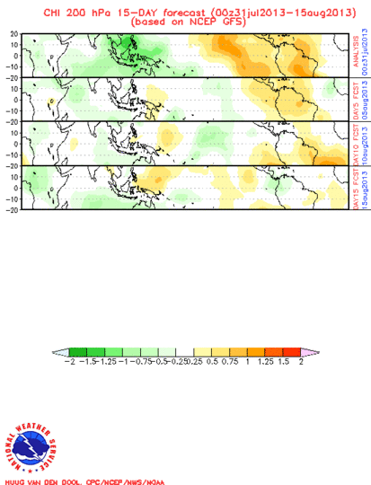
KWT wrote:Worth noting those long range forecasts that go into August the Chi 200 forecasts are real prone to changing and shifting about...

Also worth noting its based of the GFS...which has done an *shockingly bad* job on calling this current MJO cycle, the GFS called it to reach phase 6/7, in trutyh its barely going to get into 4 before diving back, such mistakes being made at 7-10 days show why we shouldn't really pay much attention to further out then that.

Anyway the ECM/GFS and other models are certainly seeing at least hints of development, will probably see things get going close to mid month in a major way.


agreed the lid is coming to off here shortly....just too much heat potential out there....
0 likes   

User avatar
Meso
Category 5
Category 5
Posts: 1609
Age: 38
Joined: Mon Aug 09, 2004 12:14 pm
Location: South Africa
Contact:

Re: Long / Medium Range Model Runs

#1256 Postby Meso » Tue Jul 27, 2010 5:44 am

For what it's worth...

00z CMC Long Range (240 Hours)

Image

Showing 2 storms, one of which develops in the Caribbean in the more believable time frame.

06z GFS Long Range (384 Hours)

Image

Begins as a strong wave exiting Africa at around 180-200 hour frame then develops at around 240 hours
0 likes   

Stormcenter
S2K Supporter
S2K Supporter
Posts: 6684
Joined: Wed Sep 03, 2003 11:27 am
Location: Houston, TX

#1257 Postby Stormcenter » Tue Jul 27, 2010 8:31 am

Yawn.........I guess I can catch up on my sleep
until August 15.
0 likes   

StormClouds63
Category 2
Category 2
Posts: 583
Age: 62
Joined: Tue May 13, 2008 11:56 am
Location: Southwest Louisiana

Re: Long / Medium Range Model Runs

#1258 Postby StormClouds63 » Tue Jul 27, 2010 10:20 am

Tropics Guy wrote:The Bermuda High looks pretty weak in that frame, possible east coast trough at that time , IF something develops during that time frame it would probably be a fish unless high pressure builds in rapidly after that, anyway nice to see that models are starting to show development out of the Atlantic soon..........

TG


I think Colin will be a "fish" too.
0 likes   

tolakram
Admin
Admin
Posts: 20010
Age: 62
Joined: Sun Aug 27, 2006 8:23 pm
Location: Florence, KY (name is Mark)

Re: Long / Medium Range Model Runs

#1259 Postby tolakram » Tue Jul 27, 2010 12:17 pm

12z Canadian hints at development at 72 hours and develops after 72. I don't trust the Canadian past 72 hours but this is worth watching. If the 0z shows development at 72 or before then I'm interested.

Image

From: http://moe.met.fsu.edu/cgi-bin/cmctc2.c ... =Animation
0 likes   
M a r k
- - - - -
Join us in chat: Storm2K Chatroom Invite. Android and IOS apps also available.

The posts in this forum are NOT official forecasts and should not be used as such. Posts are NOT endorsed by any professional institution or STORM2K.org. For official information and forecasts, please refer to NHC and NWS products.

User avatar
ronjon
Category 5
Category 5
Posts: 4822
Joined: Fri Aug 19, 2005 5:17 pm
Location: Hernando Beach, FL

Re: Long / Medium Range Model Runs

#1260 Postby ronjon » Tue Jul 27, 2010 12:35 pm

0 likes   


Return to “2015”

Who is online

Users browsing this forum: No registered users and 4 guests