ATL: 90L - ERIKA Remnants - Models

Moderator: S2k Moderators

Message
Author
jlauderdal
S2K Supporter
S2K Supporter
Posts: 7183
Joined: Wed May 19, 2004 5:46 am
Location: NE Fort Lauderdale
Contact:

Re: ATL: ERIKA - Models

#1761 Postby jlauderdal » Thu Aug 27, 2015 7:03 am

tolakram wrote:Final frame, back onshore.
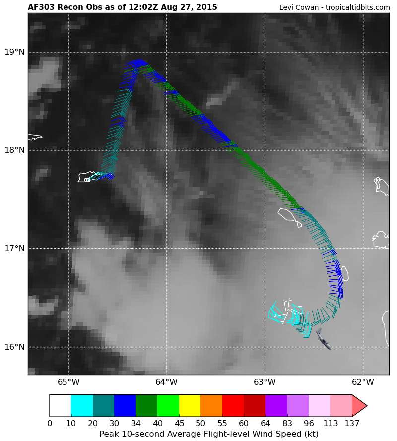
Image


its trying its hardest to hit florida some way...hurricanes hate land as they search out warm water and we have seen them literally bounce off land masses e.g south coast of jamiaca about 10 years ago
0 likes   

User avatar
drezee
S2K Supporter
S2K Supporter
Posts: 3664
Joined: Mon Jun 09, 2003 12:49 pm
Location: FL

Re: ATL: ERIKA - Models

#1762 Postby drezee » Thu Aug 27, 2015 7:04 am

CourierPR wrote:
drezee wrote:Breaking News!! The AF Recon Flew to the NHC position to find the center and found E winds at 6k ft. It has turned SW to find the center. This is major major news! If the center has shifted SE, then the models will be initialized there for 12z....fun and games my Storm2k friends


That would be a fly in the ointment. I would expect to see the models shift again. Hang on Sloopy.


After 12z and NHC with no new advisory....I would love to be a fly on the wall..."Recon found what?"
0 likes   

AutoPenalti
Category 5
Category 5
Posts: 4030
Age: 29
Joined: Mon Aug 17, 2015 4:16 pm
Location: Ft. Lauderdale, Florida

#1763 Postby AutoPenalti » Thu Aug 27, 2015 7:04 am

Windshield wipes activate! Form of Model Runs!

Haha I needed to cheer up, good morning guys.
0 likes   
The posts in this forum are NOT official forecasts and should not be used as such. They are just the opinion of the poster and may or may not be backed by sound meteorological data. They are NOT endorsed by any professional institution or STORM2K. For official information, please refer to products from the NHC and NWS.


Model Runs Cheat Sheet:
GFS (5:30 AM/PM, 11:30 AM/PM)
HWRF, GFDL, UKMET, NAVGEM (6:30-8:00 AM/PM, 12:30-2:00 AM/PM)
ECMWF (1:45 AM/PM)

TCVN
is a weighted averaged

BobHarlem
Category 5
Category 5
Posts: 2109
Joined: Thu Oct 20, 2005 6:11 pm

Re: ATL: ERIKA - Models

#1764 Postby BobHarlem » Thu Aug 27, 2015 7:06 am

Can anyone else confirm what I see in the 6Z HWRF East coast Florida scrape WPB north and landfall Cocoa Beach?
Last edited by BobHarlem on Thu Aug 27, 2015 7:07 am, edited 1 time in total.
0 likes   

User avatar
gatorcane
S2K Supporter
S2K Supporter
Posts: 23691
Age: 47
Joined: Sun Mar 13, 2005 3:54 pm
Location: Boca Raton, FL

#1765 Postby gatorcane » Thu Aug 27, 2015 7:07 am

The mean track of the last three ECMWF runs take this right into South Florida.
0 likes   

User avatar
drezee
S2K Supporter
S2K Supporter
Posts: 3664
Joined: Mon Jun 09, 2003 12:49 pm
Location: FL

Re: ATL: ERIKA - Models

#1766 Postby drezee » Thu Aug 27, 2015 7:08 am

drezee wrote:
CourierPR wrote:
drezee wrote:Breaking News!! The AF Recon Flew to the NHC position to find the center and found E winds at 6k ft. It has turned SW to find the center. This is major major news! If the center has shifted SW, then the models will be initialized there for 12z....fun and games my Storm2k friends


That would be a fly in the ointment. I would expect to see the models shift again. Hang on Sloopy.


After 12z and NHC with no new advisory....I would love to be a fly on the wall..."Recon found what?"


UMMARY OF 800 AM AST...1200 UTC...INFORMATION
----------------------------------------------
LOCATION...16.5N 62.7W
ABOUT 85 MI...140 KM W OF GUADELOUPE
MAXIMUM SUSTAINED WINDS...50 MPH...85 KM/H
PRESENT MOVEMENT...W OR 280 DEGREES AT 16 MPH...26 KM/H
MINIMUM CENTRAL PRESSURE...1005 MB...29.68 INCHES
0 likes   

BucMan2
Tropical Storm
Tropical Storm
Posts: 108
Joined: Fri Aug 21, 2015 10:05 am

#1767 Postby BucMan2 » Thu Aug 27, 2015 7:09 am

For what its worth the 06NAVGEM has Ericka going up the west coast into the Big Bend area- You figure!!!
0 likes   

User avatar
drezee
S2K Supporter
S2K Supporter
Posts: 3664
Joined: Mon Jun 09, 2003 12:49 pm
Location: FL

#1768 Postby drezee » Thu Aug 27, 2015 7:14 am

Recon did a center drop at 16.4N and 62.8W and found the center with a 10kt N wind....this is big news for downstream
0 likes   

tolakram
Admin
Admin
Posts: 20009
Age: 62
Joined: Sun Aug 27, 2006 8:23 pm
Location: Florence, KY (name is Mark)

Re: ATL: ERIKA - Models

#1769 Postby tolakram » Thu Aug 27, 2015 7:14 am

Yea, NAVGEM traverses most of the Islands, including Cuba. :)

Image
0 likes   
M a r k
- - - - -
Join us in chat: Storm2K Chatroom Invite. Android and IOS apps also available.

The posts in this forum are NOT official forecasts and should not be used as such. Posts are NOT endorsed by any professional institution or STORM2K.org. For official information and forecasts, please refer to NHC and NWS products.

OuterBanker
S2K Supporter
S2K Supporter
Posts: 1731
Joined: Wed Feb 26, 2003 10:53 am
Location: Nags Head, NC
Contact:

Re: ATL: ERIKA - Models

#1770 Postby OuterBanker » Thu Aug 27, 2015 7:14 am

And the ping pong game continues. Advantage Florida, that's just fine with me.
0 likes   

tolakram
Admin
Admin
Posts: 20009
Age: 62
Joined: Sun Aug 27, 2006 8:23 pm
Location: Florence, KY (name is Mark)

Re: ATL: ERIKA - Models

#1771 Postby tolakram » Thu Aug 27, 2015 7:16 am

Canadian has a near miss on Florida and a hit in NC.

Image
0 likes   
M a r k
- - - - -
Join us in chat: Storm2K Chatroom Invite. Android and IOS apps also available.

The posts in this forum are NOT official forecasts and should not be used as such. Posts are NOT endorsed by any professional institution or STORM2K.org. For official information and forecasts, please refer to NHC and NWS products.

tolakram
Admin
Admin
Posts: 20009
Age: 62
Joined: Sun Aug 27, 2006 8:23 pm
Location: Florence, KY (name is Mark)

Re: ATL: ERIKA - Models

#1772 Postby tolakram » Thu Aug 27, 2015 7:19 am

And a couple saved from the euro run. It has the same general idea as the GFS lat in the run, heading SE after a run up Florida and then back off the GA/SC coast.

Image

Image

Image

Image

source: http://www.tropicaltidbits.com/analysis/models/?model=ecmwf&region=watl&pkg=uv850_vort&runtime=2015082700&fh=0&xpos=0&ypos=255
0 likes   
M a r k
- - - - -
Join us in chat: Storm2K Chatroom Invite. Android and IOS apps also available.

The posts in this forum are NOT official forecasts and should not be used as such. Posts are NOT endorsed by any professional institution or STORM2K.org. For official information and forecasts, please refer to NHC and NWS products.

BucMan2
Tropical Storm
Tropical Storm
Posts: 108
Joined: Fri Aug 21, 2015 10:05 am

#1773 Postby BucMan2 » Thu Aug 27, 2015 7:19 am

Tolakram , do you give any credence to that model run?
0 likes   

tolakram
Admin
Admin
Posts: 20009
Age: 62
Joined: Sun Aug 27, 2006 8:23 pm
Location: Florence, KY (name is Mark)

Re:

#1774 Postby tolakram » Thu Aug 27, 2015 7:21 am

BucMan2 wrote:Tolakram , do you give any credence to that model run?


I have no idea, not a met. :) My take away is upper air pattern is complicated and we don't really know yet.
0 likes   
M a r k
- - - - -
Join us in chat: Storm2K Chatroom Invite. Android and IOS apps also available.

The posts in this forum are NOT official forecasts and should not be used as such. Posts are NOT endorsed by any professional institution or STORM2K.org. For official information and forecasts, please refer to NHC and NWS products.

User avatar
drezee
S2K Supporter
S2K Supporter
Posts: 3664
Joined: Mon Jun 09, 2003 12:49 pm
Location: FL

Re:

#1775 Postby drezee » Thu Aug 27, 2015 7:21 am

drezee wrote:Recon did a center drop at 16.4N and 62.8W and found the center with a 10kt N wind....this is big news for downstream

Not sure there is no vortex message, clean wind shift...pressure signature...temp profile

tolakram wrote:Image
0 likes   

tolakram
Admin
Admin
Posts: 20009
Age: 62
Joined: Sun Aug 27, 2006 8:23 pm
Location: Florence, KY (name is Mark)

Re: Re:

#1776 Postby tolakram » Thu Aug 27, 2015 7:26 am

drezee wrote:
drezee wrote:Recon did a center drop at 16.4N and 62.8W and found the center with a 10kt N wind....this is big news for downstream

Not sure there is no vortex message, clean wind shift...pressure signature...temp profile


Most likely multiple centers at the moment, like the HWRF predicted. Sheared system, etc. It may mean a west shift, it may not.
0 likes   
M a r k
- - - - -
Join us in chat: Storm2K Chatroom Invite. Android and IOS apps also available.

The posts in this forum are NOT official forecasts and should not be used as such. Posts are NOT endorsed by any professional institution or STORM2K.org. For official information and forecasts, please refer to NHC and NWS products.

User avatar
drezee
S2K Supporter
S2K Supporter
Posts: 3664
Joined: Mon Jun 09, 2003 12:49 pm
Location: FL

Re: Re:

#1777 Postby drezee » Thu Aug 27, 2015 7:32 am

tolakram wrote:
drezee wrote:
drezee wrote:Recon did a center drop at 16.4N and 62.8W and found the center with a 10kt N wind....this is big news for downstream

Not sure there is no vortex message, clean wind shift...pressure signature...temp profile


Most likely multiple centers at the moment, like the HWRF predicted. Sheared system, etc. It may mean a west shift, it may not.


With multiple centers, you typically see more dramatic wind shifts...it is possible since they haven't sampled all areas.
0 likes   

OuterBanker
S2K Supporter
S2K Supporter
Posts: 1731
Joined: Wed Feb 26, 2003 10:53 am
Location: Nags Head, NC
Contact:

Re: ATL: ERIKA - Models

#1778 Postby OuterBanker » Thu Aug 27, 2015 7:40 am

tolakram wrote:Canadian has a near miss on Florida and a hit in NC.

Image


Breathing a sigh of relief. It's the Canadian. :D
0 likes   

User avatar
Blown Away
S2K Supporter
S2K Supporter
Posts: 10146
Joined: Wed May 26, 2004 6:17 am

Re: ATL: ERIKA - Models

#1779 Postby Blown Away » Thu Aug 27, 2015 7:47 am

12z... Decent shift west, TVCN consensus just offshore SFL now...
Image

12z... Lots of Cat 2-4 When Erika Is Near SFL...
Image

06z.. For Comparison...
Image
0 likes   
Hurricane Eye Experience: David 79, Irene 99, Frances 04, Jeanne 04, Wilma 05... EYE COMING MY WAY IN 2024…
Hurricane Brush Experience: Andrew 92, Erin 95, Floyd 99, Matthew 16, Irma 17, Ian 22, Nicole 22…

OuterBanker
S2K Supporter
S2K Supporter
Posts: 1731
Joined: Wed Feb 26, 2003 10:53 am
Location: Nags Head, NC
Contact:

Re: ATL: ERIKA - Models

#1780 Postby OuterBanker » Thu Aug 27, 2015 7:53 am

Blown Away wrote:12z... Decent shift west, TVCN consensus just offshore SFL now...
Image

12z... Lots of Cat 2-4 When Erika Is Near SFL...
Image

06z.. For Comparison...
Image

That actully looks worse for the Carolinas. The out to seas shifted west too.
0 likes   


Return to “2015”

Who is online

Users browsing this forum: No registered users and 4 guests