Global model runs discussion

Moderator: S2k Moderators

Message
Author
User avatar
AJC3
Admin
Admin
Posts: 3999
Age: 61
Joined: Tue Aug 31, 2004 7:04 pm
Location: Ballston Spa, New York
Contact:

Re: Global Model Runs Discussion

#3081 Postby AJC3 » Wed Oct 05, 2011 5:08 am

KUEFC wrote:Just out of interest, just been reading the NWS melbourne discussion today, what does PENDERGRAST, and LASCODY refer to in the aviation section? aviation is a general interest of mine and this is probably the wrong part of the forum to ask this, but can anyone tell me?


"VFR AREA WIDE WITH WND GUSTS ABV 20KTS DURING AFTN OVER
COASTAL CO'S AND INLAND TO SFB-MCO. OCNL CIGS NR FL 040 IN
ONSHORE MOVG SC THROUGH THE PERIOD WTH ISOLD -SHRA."

This is basically saying that there will be VFR (visual flight rules) with some gusts in the 20-25 MPH range and an occasional cloud deck at 4,000 feet AGL (above ground level) with isolated light rain showers this afternoon at the local airports. VFR simply means visibilties are greater than 5 miles and there are no broken or overcast clouds at or below 3,000 feet AGL.
0 likes   

KUEFC
Tropical Storm
Tropical Storm
Posts: 137
Joined: Thu Sep 11, 2008 6:19 am

#3082 Postby KUEFC » Wed Oct 05, 2011 6:03 am

Thanks again AJC3, am pretty up on all other aviation terms apart from the weather ones!
0 likes   

KUEFC
Tropical Storm
Tropical Storm
Posts: 137
Joined: Thu Sep 11, 2008 6:19 am

#3083 Postby KUEFC » Wed Oct 05, 2011 6:20 am

06Z GFS now flipped back over to the east coast of florida, how come it keeps doing that? flipping back and forward between coasts? which is the most trusted model run? 00Z or 06Z?
0 likes   

User avatar
NDG
S2K Supporter
S2K Supporter
Posts: 15446
Joined: Sun Jul 09, 2006 10:14 pm
Location: Orlando, FL

Re: Global Model Runs Discussion

#3084 Postby NDG » Wed Oct 05, 2011 6:20 am

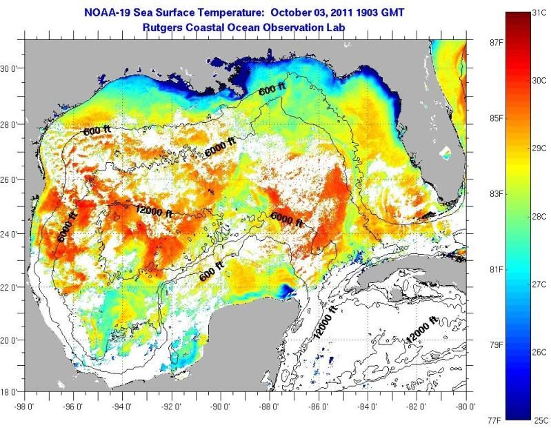
MGC wrote:The NGOM has cooled quite a bit the past several days. Bouy 42067, just south of the Mississippi Coast is reporting a SST of 78.4F as of today. The cold front that dropped our temperature into the upper 40's the past couple of mornings has worked magic on gulf temps......MGC


Like somebody else mentioned also, SSTs below 80 degs in GOM are only found in the immediate coastal waters of the northern GOM, you go approximate 50 miles offshore or less to see that SSTs are in the low 80s with the rest of the open waters of the GOM are in the low to mid 80s.

Image
0 likes   

User avatar
cycloneye
Admin
Admin
Posts: 145299
Age: 68
Joined: Thu Oct 10, 2002 10:54 am
Location: San Juan, Puerto Rico

Re:

#3085 Postby cycloneye » Wed Oct 05, 2011 6:26 am

KUEFC wrote:06Z GFS now flipped back over to the east coast of florida, how come it keeps doing that? flipping back and forward between coasts? which is the most trusted model run? 00Z or 06Z?


The best runs that have much more data obtained to feed the models are 00z and 12z.
0 likes   
Visit the Caribbean-Central America Weather Thread where you can find at first post web cams,radars
and observations from Caribbean basin members Click Here

KUEFC
Tropical Storm
Tropical Storm
Posts: 137
Joined: Thu Sep 11, 2008 6:19 am

Re: Re:

#3086 Postby KUEFC » Wed Oct 05, 2011 6:29 am

cycloneye wrote:
KUEFC wrote:06Z GFS now flipped back over to the east coast of florida, how come it keeps doing that? flipping back and forward between coasts? which is the most trusted model run? 00Z or 06Z?


The best runs that have much more data obtained to feed the models are 00z and 12z.

Thanks, and they are the models that are pointing to the more westward solution i belive?
0 likes   

User avatar
TampaFl
S2K Supporter
S2K Supporter
Posts: 1904
Age: 67
Joined: Thu Sep 04, 2003 11:23 am
Location: Tampa, FL

Re: Global Model Runs Discussion

#3087 Postby TampaFl » Wed Oct 05, 2011 6:34 am

Wed. morning NWS Tampa:

AREA FORECAST DISCUSSION
NATIONAL WEATHER SERVICE TAMPA BAY RUSKIN FL
300 AM EDT WED OCT 5 2011

LONG TERM (FRIDAY NIGHT-TUESDAY)...
STRONG SURFACE HIGH PRESSURE WILL HOLD ALONG THE MID ATLANTIC COAST
THROUGH THE WEEKEND WITH A STATIONARY BOUNDARY OVER THE FLORIDA
STRAITS. TIGHT PRESSURE GRADIENT BETWEEN THE TWO SYSTEMS WILL
CONTINUE OVER THE EASTERN GULF OF MEXICO WITH SMALL CRAFT ADVISORY
CONDITIONS A GOOD POSSIBILITY. CONSIDERABLE UNCERTAINTY IN THE LONG
RANGE FORECAST AS THE GFS AND ECMWF GENERATE A LOW PRESSURE SYSTEM
ON THE STATIONARY BOUNDARY LATE IN THE WEEKEND AND LIFT THE LOW
NORTHWEST TO WEST NORTHWEST...WITH DIFFERING SOLUTIONS ON HOW IT
COULD AFFECT WEST CENTRAL AND SOUTHWEST FLORIDA. THE TAIL END OF A
FRONTAL BOUNDARY IS A VERY TYPICAL LOCATION FOR A TROPICAL SYSTEM TO
DEVELOP DURING THE MONTH OF OCTOBER. WITH THE HIGH DEGREE OF
UNCERTAINTY REGARDING IF A LOW DEVELOPS AND WHERE IT WOULD
EVENTUALLY TRACK...THIS AREA WILL HAVE TO BE CLOSELY MONITORED
THROUGH THE REMAINDER OF THE WEEK AS THERE WILL LIKELY BE CHANGES IN
MODEL SOLUTIONS FROM RUN TO RUN. REGARDLESS...STRONG EASTERLY FLOW
ALONG WITH A FRONTAL BOUNDARY GRADUALLY LIFTING NORTH WILL ADVECT
DEEP LAYER MOISTURE OVER THE FORECAST AREA WITH AN INCREASING CHANCE
OF SHOWERS AND POSSIBLE THUNDERSTORMS OVER THE WEEKEND INTO NEXT
WEEK...SO WILL TREND POPS HIGHER. TEMPERATURES WILL RUN NEAR
CLIMATIC NORMALS TO A FEW DEGREES ABOVE CLIMATIC NORMALS.
0 likes   
The posts in this forum are NOT official forecasts and should not be used as such. They are just the opinion of the poster and may or may not be backed by sound meteorological data. They are NOT endorsed by any professional institution or STORM2K. For official information, please refer to products from the NHC and NWS.

User avatar
cycloneye
Admin
Admin
Posts: 145299
Age: 68
Joined: Thu Oct 10, 2002 10:54 am
Location: San Juan, Puerto Rico

Re: Global Model Runs Discussion

#3088 Postby cycloneye » Wed Oct 05, 2011 7:02 am

From Key West AFD

AREA FORECAST DISCUSSION FOR THE FLORIDA KEYS
NATIONAL WEATHER SERVICE KEY WEST FL
418 AM EDT WED OCT 5 2011

LONG TERM (FRIDAY THROUGH TUESDAY)...
GUIDANCE AGREES ON THE GENERAL IDEA OF A PRONOUNCED REX BLOCK
CONFIGURATION TAKING SHAPE ACROSS EASTERN NORTH AMERICA DURING THE
LONG TERM PERIOD...WITH STRONG RIDGING OVER THE OHIO VALLEY AND GREAT
LAKES...AND A LARGE MID/UPPER LEVEL TROUGH DEVELOPING NEAR FLORIDA.
THIS PATTERN WILL MAINTAIN STRONG SURFACE HIGH PRESSURE ALONG THE
EASTERN SEABOARD...WITH BRISK EASTERLY FLOW CONTINUING INITIALLY INTO
SOUTH FLORIDA AND THE KEYS. HOWEVER...THE DETAILS OF THE FORECAST
BECOME VERY UNCERTAIN DURING THE WEEKEND INTO EARLY NEXT WEEK...AS
MUCH OF THE GUIDANCE CONTINUES TO PERSIST IN THE IDEA OF A
SUBTROPICAL OR HYBRID SURFACE LOW PRESSURE DEVELOPMENT SOMEWHERE NEAR
CUBA SATURDAY NIGHT INTO SUNDAY...WITH THIS LOW THEN TRACKING
NORTHWEST INTO THE GULF OF MEXICO OR POSSIBLY ACROSS FLORIDA EARLY
NEXT WEEK.

SINCE ANY POSSIBLE LOW PRESSURE AREA IS STILL A FEW DAYS AWAY FROM
EVEN DEVELOPING...OBVIOUSLY THE DETAILS OF THE FORECAST ARE QUITE
DIFFICULT TO PIN DOWN AT THIS POINT. IT DOES APPEAR THAT THE REGION
SHOULD SEE INCREASING RAIN CHANCES STARTING ON FRIDAY AS THE UPPER
LEVEL TROUGH DIGS INTO THE EASTERN GULF AND AVAILABLE MOISTURE
DEEPENS...AND INCREASED POPS A NOTCH TO 40 PERCENT. FOR THE WEEKEND
INTO EARLY NEXT WEEK...FAVORED THE ECMWF SCENARIO FOR NOW SINCE IT
HAS REMAINED QUITE CONSISTENT FOR ITS PAST THREE RUNS...SHOWING A
WEAK LOW NEAR WESTERN CUBA SUNDAY MORNING WHICH THEN TRACKS NORTHWEST
AND NORTH ACROSS THE EASTERN GULF THROUGH TUESDAY. BUMPED POPS UP TO
40 PERCENT FOR FRIDAY NIGHT THROUGH SUNDAY WHEN MOISTURE AND UPPER
LEVEL DYNAMICS APPEAR MORE FAVORABLE FOR RAINFALL ACROSS THE KEYS...
THEN RETURNED TO 30 PERCENT POPS THEREAFTER. THIS PORTION OF THE
FORECAST MAY BE SUBJECT TO CONSIDERABLE CHANGE DURING THE NEXT FEW
DAYS...SO STAY TUNED.
0 likes   
Visit the Caribbean-Central America Weather Thread where you can find at first post web cams,radars
and observations from Caribbean basin members Click Here

User avatar
dizzyfish
S2K Supporter
S2K Supporter
Posts: 1519
Joined: Fri Sep 16, 2005 7:56 am
Location: New Port Richey, FL

Re: Global Model Runs Discussion

#3089 Postby dizzyfish » Wed Oct 05, 2011 8:02 am

Listening to the radio on the way to work this morning and they mentioned this and had a voice quote from the NWS in Tampa. Not a usual thing to hear.
0 likes   

User avatar
jdray
Category 3
Category 3
Posts: 853
Joined: Tue Aug 31, 2004 10:07 pm
Location: NE Florida

Re: Global Model Runs Discussion

#3090 Postby jdray » Wed Oct 05, 2011 8:51 am

000
FXUS62 KJAX 050815
AFDJAX

AREA FORECAST DISCUSSION
NATIONAL WEATHER SERVICE JACKSONVILLE FL
415 AM EDT WED OCT 5 2011

.SHORT TERM...LARGE HIGH PRESSURE SYSTEM CONTINUES TO DOMINATE MUCH
OF THE EASTERN UNITED STATES WITH A LONG FETCH OF NORTHEASTERLY
WINDS NOTED OVER THE SOUTHEAST UNITED STATES. SATELLITE IMAGERY
SHOWS AN EXPANSIVE CU FIELD OVER THE LOCAL ATLANTIC WATERS. SOME
OF THESE CLOUDS ARE ALSO SPREADING ONSHORE OVER FLAGLER... ST.
JOHNS...AND PUTNAM COUNTIES WHERE ISENTROPIC LIFT HAS ESTABLISHED.

TODAY...NORTHEASTERLY WINDS WILL FURTHER INCREASE WITH BREEZY
CONDITIONS LIKELY TO ESTABLISH EAST OF U.S. HIGHWAY 301. WE
ANTICIPATE AN EXPANSIVE CU FIELD OVER OUR EASTERN ZONES DURING THE
DAY. HIGH TEMPERATURES WILL ONCE AGAIN CLIMB INTO THE LOWER TO MID
80S. A FEW SHOWERS WILL ESTABLISH OVER THE LOCAL WATERS...BUT
ANOTHER DRY DAY IS FORECAST ACROSS THE LOCAL MAINLAND.

TONIGHT...NUMERICAL MODELS ARE IN GOOD AGREEMENT AN INVERTED
TROUGH WILL BEGIN TO ESTABLISH IN THE LOCAL WATERS. THIS FEATURE
WILL BE THE FOCUS FOR ISOLATED COASTAL SHOWERS...WITH ISOLATED
SHOWERS POSSIBLY IMPACTING FLAGLER COUNTY AS WELL.

THURSDAY/THURSDAY NIGHT...STRONG HIGH PRESSURE WILL REMAIN ANCHORED
NORTH OF THE AREA WITH INVERTED TROUGH LIKELY TO STRENGTHEN IN THE
LOCAL WATERS... ACCOMPANIED BY BROAD AREA OF CONVERGENCE. SCATTERED
SHOWERS ARE ANTICIPATED OVER THE COASTAL SECTIONS...WITH SHOWER
ACTIVITY SPREADING FARTHER INLAND DURING THE AFTERNOON. BREEZY
CONDITIONS ALONG THE COAST WILL TRANSLATE INLAND WITH DAYTIME
HEATING.

ISOLATED/SCATTERED SHOWERS ARE FORECAST OVER THE EASTERN ZONES
THURSDAY NIGHT.


FRIDAY...SIMILAR SETUP AS THURSDAY WITH COASTAL SHOWERS SLOWLY
SPREADING INLAND DURING THE DAY...ALTHOUGH OVERALL WE ANTICIPATE
SLIGHTLY LESS COVERAGE. BREEZY NORTHEAST WINDS WILL BE ONGOING
ALONG THE COAST WITH THESE WINDS ESTABLISHING ACROSS INLAND
SECTIONS DURING THE MID/LATE MORNING.

.LONG TERM...
AS BEEN ADVERTISED...A SIGNIFICANT COASTAL EVENT IS FORECAST THIS
WEEKEND AND INTO EARLY NEXT WEEK IN RESPONSE TO TIGHTENING PRESSURE
GRADIENT AND STRONG NORTHEASTERLY WINDS. THESE CONDITIONS WILL
PRESENT HIGH SURF...BEACH EROSION AND POSSIBLE COASTAL FLOODING
DURING TIMES OF HIGH TIDE. RAIN CHANCES REMAIN HIGHEST ACROSS OUR
EASTERN ZONES...CAPPING POPS JUST BELOW LIKELY CATEGORY DUE TO
UNCERTAINTY WHERE PERSISTENT BANDS WILL ESTABLISH.


ANOTHER FEATURE OF INTEREST IN THE EXTENDED PERIOD IS A DEVELOPING
AREA OF LOW PRESSURE IN THE CARIBBEAN. MODELS CONTINUE TO DIFFER
ON TRACK/INTENSITY OF THIS FEATURE EARLY NEXT WEEK. WILL CONTINUE
TO CLOSELY FOLLOW THE GFS ENSEMBLE AS THE DGEX SOLN REMAINS THE
EASTERN-MOST OUTLIER...LIFTING AFOREMENTIONED LOW NORTH OVER THE
BAHAMAS AS WELL AS THE FLORIDA ATLANTIC WATERS. HEIGHT FIELDS
WILL LIKELY REMAIN TOO HIGH OVER THE EASTERN SEABOARD FOR THIS
SCENARIO. THE GFS ENSEMBLE LIFTS LOW NORTH-NORTHWEST INTO THE
EASTERN GULF OF MEXICO
.


The inverted trough mixed with the possible low and the pressure gradient against the high should make for some interesting weather.
0 likes   

maxx9512
Tropical Storm
Tropical Storm
Posts: 114
Age: 65
Joined: Thu May 31, 2007 7:55 pm
Location: Cape Coral, Fl.

Re: Global Model Runs Discussion

#3091 Postby maxx9512 » Wed Oct 05, 2011 8:57 am

NATIONAL WEATHER SERVICE TAMPA BAY RUSKIN FL
942 AM EDT WED OCT 5 2011

MODELS ARE STILL INCONSISTENT ON THE DEVELOPMENT...AND EVENTUAL
TRACK OF AN AREA OF LOW PRESSURE NEAR FLORIDA THIS WEEKEND.
MARINERS SHOULD MONITOR LATER FORECASTS AND UPDATES IF PLANNING
TRIPS INTO THE GULF THIS WEEKEND.
0 likes   

floridasun78
Category 5
Category 5
Posts: 3755
Joined: Sun May 17, 2009 10:16 pm
Location: miami fl

Re: Global Model Runs Discussion

#3092 Postby floridasun78 » Wed Oct 05, 2011 10:35 am

AREA FORECAST DISCUSSION
NATIONAL WEATHER SERVICE MIAMI FL ISSUED 421 AM EDT WED OCT 5 2011/
EXTENDED FORECAST...
THIS WEEKEND WEATHER WILL DEPEND ON WHERE THE FRONT IS LOCATED AND
IF A SUBTROPICAL OR TROPICAL LOW PRESSURE SYSTEM DEVELOPS ALONG IT
OR NOT. AT THIS TIME THE...ECMWF MODEL SHOW A LOW DEVELOPING OVER
THE EASTERN GULF OF MEXICO LATE FRIDAY INTO SATURDAY AND MOVING IT
TO THE NORTH TOWARDS THE PANHANDLE LATE THIS WEEKEND INTO EARLY
NEXT WEEK PULLING THE FRONT THROUGH SOUTH FLORIDA ON SATURDAY INTO
EARLY SUNDAY MORNING. THE GFS MODEL SHOWS A WEAK LOW TO DEVELOP IN
THE FLORIDA KEYS AND MOVES IT TO THE NORTHWEST TOWARDS THE WESTERN
PANHANDLE DURING THE SAME TIME PULLING THE FRONT THROUGH THE CWA ON
SATURDAY.

SO WILL CONTINUE THE SCATTERED POPS OVER SOUTH FLORIDA THIS
WEEKEND WITH THE BEST CHANCE ON SATURDAY INTO SATURDAY NIGHT...AS
THE FRONT MOVES THROUGH THE CWA. DUE TO THE LACK OF SUNSHINE ON
SATURDAY ACROSS THE MOST OF THE CWA...THE THUNDER CHANCE WILL BE
LOW OVER THE AREA. ON SUNDAY...THE THUNDER CHANCE WILL REMAIN LOW
OVER SOUTH FLORIDA AS THE DEEPER MOISTURE AND THE ENERGY SUPPORT
WILL BE NORTH OF THE CWA. FOR RAINFALL AMOUNTS FROM THIS EVENT
0 likes   

User avatar
cycloneye
Admin
Admin
Posts: 145299
Age: 68
Joined: Thu Oct 10, 2002 10:54 am
Location: San Juan, Puerto Rico

Re: Global Model Runs Discussion

#3093 Postby cycloneye » Wed Oct 05, 2011 10:54 am

Discussion of potential development by Dr Jeff Masters.

A large low pressure system with heavy rains is expected to develop over Cuba and South Florida on Saturday. The counter-clockwise flow around this low will bring strong winds and heavy rains to much of the Florida coast on Saturday, and these conditions will spread northwards to Georgia by Sunday and South Carolina by Monday. Most of the models develop this system into a tropical or subtropical storm, but the potential location of such a storm is still murky. The ECMWF model predicts the storm will form in the eastern Gulf of Mexico on Monday, then move north into the Florida Panhandle on Tuesday. If this track verifies, the oil rigs off the coast of Southeast Louisiana may experience a one or two day period of sustained winds above tropical storm force Monday or Tuesday. The GFS and NOGAPS models put the storm on the other side of Florida, over the Northwestern Bahamas, and predict the storm will move northwards and hit North Carolina on Wednesday. The UKMET model is in-between, developing the storm right on top of Florida. Since the storm is going to be getting its start as a cold-cored upper-level low pressure system with some dry air aloft, it will probably start out subtropical, with a large band of heavy rain developing well north of the center, bringing heavy rains to a wide region of the Southeast U.S. Subtropical storms cannot intensify quickly, due to their lack of an organized inner core. If the storm follows the path of the GFS model, it could be similar to Subtropical Storm Four of October 4, 1974. That storm brought 10 - 14 inches of rain to the east coast of Florida and strong onshore winds of 30 - 40 mph that caused beach erosion and coastal flooding. The extended forecast discussion from NOAA's Hydrometeorological Prediction Center has a more technical discussion of this coming storm for those interested.

0 likes   
Visit the Caribbean-Central America Weather Thread where you can find at first post web cams,radars
and observations from Caribbean basin members Click Here

KUEFC
Tropical Storm
Tropical Storm
Posts: 137
Joined: Thu Sep 11, 2008 6:19 am

Re: Global Model Runs Discussion

#3094 Postby KUEFC » Wed Oct 05, 2011 11:13 am

Why does he say this will hit saturday but wont form till monday? Starting to worry again now :(
0 likes   

User avatar
cycloneye
Admin
Admin
Posts: 145299
Age: 68
Joined: Thu Oct 10, 2002 10:54 am
Location: San Juan, Puerto Rico

Re: Global Model Runs Discussion

#3095 Postby cycloneye » Wed Oct 05, 2011 11:56 am

After the first development of sub or tropical system,today's 12z GFS develops at least two more Caribbean systems in the long range.See loop below.

12z GFS loop
0 likes   
Visit the Caribbean-Central America Weather Thread where you can find at first post web cams,radars
and observations from Caribbean basin members Click Here

KUEFC
Tropical Storm
Tropical Storm
Posts: 137
Joined: Thu Sep 11, 2008 6:19 am

Re: Global Model Runs Discussion

#3096 Postby KUEFC » Wed Oct 05, 2011 12:55 pm

Can any pro mets please reassure me with regard to saturday please? Things seem to have moved forward to what they where would be devestated if my flight was cancelled :(
0 likes   

Dean4Storms
S2K Supporter
S2K Supporter
Posts: 6358
Age: 62
Joined: Sun Aug 31, 2003 1:01 pm
Location: Miramar Bch. FL

Re: Global Model Runs Discussion

#3097 Postby Dean4Storms » Wed Oct 05, 2011 1:57 pm

cycloneye wrote:After the first development of sub or tropical system,today's 12z GFS develops at least two more Caribbean systems in the long range.See loop below.

12z GFS loop


Still further east with this first low, not sure I buy it generating over the Bahamas.
0 likes   

User avatar
chaser1
S2K Supporter
S2K Supporter
Posts: 5464
Age: 64
Joined: Sat Oct 15, 2005 5:59 pm
Location: Longwood, Fl

Re: Global Model Runs Discussion

#3098 Postby chaser1 » Wed Oct 05, 2011 2:01 pm

KUEFC wrote:Can any pro mets please reassure me with regard to saturday please? Things seem to have moved forward to what they where would be devestated if my flight was cancelled :(


As a potential genesis candidate for a tropical cyclone, this somewhat typical fall "transitional" set up is both interesting & challenging to both Meteorologists and enthusiasts alike. If and when this low should acquire more warm core characteristics and perhaps deepen a little, I could see the potential for a moderate to strong tropical storm to possibly impact the Northern Gulf Coast (probably Fla. Panhandle to Apalachicola region) with significant rains over a broader area of Central/N. Florida, then spreading NNE'ward. I am certainly not downplaying possible flooding or isolated wind impact that may well occur elsewhere.

That said however......, I don't think anyone in or coming to South Florida should get their pants in a bunch over this "big event". Yes, small boaters will be best advised to probably keep it on the dinghy and Yes, we may pick up a solid 2"-6" of rain here locally. Rip tides, perhaps a little beach erosion....hey maybe 2 or 3 ( very isolated spots ) "might" experience a gust to near 45mph! I am not downplaying these likely conditions, and in fact am an enthusiast who loves bad weather. I'm checking these same forum boards 2-3 times a day because, well...like many here, thats what i'm into as well. All I am saying is: whatever evolves from THIS possible cyclogenesis, I can nearly guarantee conditions in S. Florida will NOT approach anything that would shut schools, cause work stoppages, freeze our airports, cause homeowners to put up shutters, or end life as we know it, etc.

Those concerned may now take a deep breath and repeat after me: "Baroclinic blustery blobs behave like big colicky babies, but seldom break things". What may follow in about 10 days could be another story and may be the third such type system to come out of the W. Caribbean this fall ( based on the 12Z GFS anyways ). Not too early to speculate, but way too early to worry.
0 likes   
Andy D

(For official information, please refer to the NHC and NWS products.)

KUEFC
Tropical Storm
Tropical Storm
Posts: 137
Joined: Thu Sep 11, 2008 6:19 am

Re: Global Model Runs Discussion

#3099 Postby KUEFC » Wed Oct 05, 2011 2:09 pm

Only problem is i am going to Orlando and not south florida lol
0 likes   

User avatar
'CaneFreak
Category 5
Category 5
Posts: 1486
Joined: Mon Jun 05, 2006 10:50 am
Location: New Bern, NC

Re: Global Model Runs Discussion

#3100 Postby 'CaneFreak » Wed Oct 05, 2011 2:24 pm

I am taking the "I'll believe it when I see it" approach :-)
0 likes   


Return to “2015”

Who is online

Users browsing this forum: No registered users and 4 guests