
Global model runs discussion
Moderator: S2k Moderators
-
cycloneye

- Admin

- Posts: 149505
- Age: 69
- Joined: Thu Oct 10, 2002 10:54 am
- Location: San Juan, Puerto Rico
Re: Global Model Runs Discussion
Still showing up on GFS ten days out. And it still has a semi-hybrid look. I dont think it will be Subtropical Storm Alberto,but neverless,is a little bit interesting to see it.See last 4 posts of prior page to see where this started.
0 likes
Visit the Caribbean-Central America Weather Thread where you can find at first post web cams,radars
and observations from Caribbean basin members Click Here
and observations from Caribbean basin members Click Here
-
wxman57

- Moderator-Pro Met

- Posts: 23175
- Age: 68
- Joined: Sat Jun 21, 2003 8:06 pm
- Location: Houston, TX (southwest)
Re: Global Model Runs Discussion
Such lows, typically referred to as west Gulf lows, are quite common in the Gulf during the winter months. They typically form on a baroclinic zone (front) that lies stationary across the northern Gulf. The low forms as an approaching upper-level trof reaches west Texas. Sometimes, these lows can be quite strong (March 1993 superstorm). Most of the times, winds north of the front (in the cold air) are in the 25-35 kt range offshore and the low just produces a lot of rain along the Gulf Coast.
The GFS's prediction of the low above is highly-dependent on a frontal boundary being present offshore at that time. If the forecast of a cold front being offshore is wrong, then no low will form.
The GFS's prediction of the low above is highly-dependent on a frontal boundary being present offshore at that time. If the forecast of a cold front being offshore is wrong, then no low will form.
0 likes
-
cycloneye
- Admin
- Posts: 149505
- Age: 69
- Joined: Thu Oct 10, 2002 10:54 am
- Location: San Juan, Puerto Rico
Re: Global Model Runs Discussion
HWRF will be upgraded in May 2012
Subject: Soliciting Public Comments on Modification of Product
Dissemination Time of Hurricane Weather Research and
Forecast (HWRF) System Products through March 9, 2012
NCEP is proposing to upgrade the Hurricane Weather Research and
Forecast (HWRF) modeling system in May 2012. This upgrade would
result in HWRF products being distributed to the National
Hurricane Center (NHC) and to the public up to 20 minutes later
than the current distribution time. The NWS is seeking comments
on this proposed upgrade and resultant distribution schedule
change by March 9, 2012.
The proposed upgrades to the HWRF modeling system would be:
- Inclusion of a very high-resolution storm-following third nest
operating at 3 km horizontal resolution within a 9 km
intermediate domain and 27 km outer domain
- A centroid-based nest motion algorithm for accurate storm
tracking
- Improved vortex initialization applicable for 3 km horizontal
resolution and upgraded GSI
- Improved PBL, convection and microphysics parameterizations
- Improved synthetic satellite products for GOES and microwave
imagers
- A very high temporal resolution tracker product
The benefits to the user community would be improved hurricane
track, intensity and structure prediction.
The delayed delivery time would affect all HWRF products
distributed through NOAAPORT, the NWS ftp server and the NCEP
ftp/http server.
More details about the HWRF are available at:
http://www.emc.ncep.noaa.gov/HWRF/
At the close of the public comment period, NWS will evaluate the
comments to determine whether to proceed with this upgrade to the
HWRF as planned. If a decision is made to move forward, a
Technical Information Notice will be issued containing the
implementation date and more details about the upgrade and
resultant product delays.
Please send comments on this proposal to:
Vijay Tallapragada
Hurricane Team Leader
NWS/NCEP Environmental Modeling Center
301-763-8000 x7232
Vijay.Tallapragada@noaa.gov
http://www.srh.noaa.gov/productview.php ... n=1&max=61
0 likes
Visit the Caribbean-Central America Weather Thread where you can find at first post web cams,radars
and observations from Caribbean basin members Click Here
and observations from Caribbean basin members Click Here
-
Rgv20

- S2K Supporter

- Posts: 2466
- Age: 39
- Joined: Wed Jan 05, 2011 5:42 pm
- Location: Edinburg/McAllen Tx
12zNogaps showing a 1006mb Low in the Gulf of Mexico around Friday/or Saturday. Thanks for the explanation wxman57 , correct me if I'm wrong but I notice that these lows usually start in the Lower Texas Coast and then wreck havoc a few days later in the North East..
0 likes
The following post is NOT an official forecast and should not be used as such. It is just the opinion of the poster and may or may not be backed by sound meteorological data. It is NOT endorsed by any professional institution including storm2k.org For Official Information please refer to the NHC and NWS products.
-
cycloneye
- Admin
- Posts: 149505
- Age: 69
- Joined: Thu Oct 10, 2002 10:54 am
- Location: San Juan, Puerto Rico
Re: Global Model Runs Discussion
I would not be surprised to see invest 91L from this if (big if) it does the same type of organizing phase as 90L. GFS has been with it for many runs since January 29th.
0 likes
Visit the Caribbean-Central America Weather Thread where you can find at first post web cams,radars
and observations from Caribbean basin members Click Here
and observations from Caribbean basin members Click Here
-
Hurricaneman

- Category 5

- Posts: 7404
- Age: 45
- Joined: Tue Aug 31, 2004 3:24 pm
- Location: central florida
Re: Global Model Runs Discussion
These pre season possibilities scare me a little. The GFS is showing something new later in the week
0 likes
-
cycloneye
- Admin
- Posts: 149505
- Age: 69
- Joined: Thu Oct 10, 2002 10:54 am
- Location: San Juan, Puerto Rico
Re: Global Model Runs Discussion
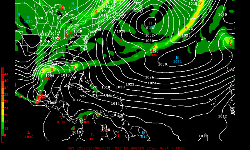
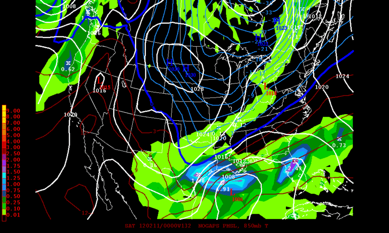
NOGAPS continues to show the GOM system,but it moves rapidly to the northeast towards the gulf coast without developing into a sub or tropical feature system.

Uploaded by imageshack.us
Uploaded by imageshack.us
0 likes
Visit the Caribbean-Central America Weather Thread where you can find at first post web cams,radars
and observations from Caribbean basin members Click Here
and observations from Caribbean basin members Click Here
-
TexasStorm

- Tropical Storm

- Posts: 174
- Joined: Wed Jul 16, 2008 10:00 am
- Location: North Texas
Re: Global Model Runs Discussion
Mid February and we are already blob watching! Lord help us if this is an indication of how the season is going to be.
0 likes
-
cycloneye
- Admin
- Posts: 149505
- Age: 69
- Joined: Thu Oct 10, 2002 10:54 am
- Location: San Juan, Puerto Rico
Re: Global Model Runs Discussion
I know I know is 300 hours away,is March and will be nothing,but what is that over me??
2/29/12 00z GFS

00z Loop
Uploaded with ImageShack.us
2/29/12 00z GFS
00z Loop
Uploaded with ImageShack.us
0 likes
Visit the Caribbean-Central America Weather Thread where you can find at first post web cams,radars
and observations from Caribbean basin members Click Here
and observations from Caribbean basin members Click Here

-
cycloneye
- Admin
- Posts: 149505
- Age: 69
- Joined: Thu Oct 10, 2002 10:54 am
- Location: San Juan, Puerto Rico
Re: Global Model Runs Discussion
NHC Verification of models performance in 2011
The ECMWF and GFS were the best dynamic models while NOGAPS was the poorest. TVCA was the best consensus model.
I say no surprise on all accounts.
http://www.nhc.noaa.gov/verification/pd ... n_2011.pdf
The ECMWF and GFS were the best dynamic models while NOGAPS was the poorest. TVCA was the best consensus model.
I say no surprise on all accounts.
http://www.nhc.noaa.gov/verification/pd ... n_2011.pdf
0 likes
Visit the Caribbean-Central America Weather Thread where you can find at first post web cams,radars
and observations from Caribbean basin members Click Here
and observations from Caribbean basin members Click Here
-
cycloneye
- Admin
- Posts: 149505
- Age: 69
- Joined: Thu Oct 10, 2002 10:54 am
- Location: San Juan, Puerto Rico
Re: Global Model Runs Discussion
GFDL will be upgraded on May 15
Let's see how the model performs and hopefully,we dont see bogus storms after the upgrade.
http://www.nws.noaa.gov/os/notification ... 18gfdl.htm
Excerpt:
- Bug fix in PBL scheme from 2003 implementation
- Bug fix in Simplified Arakawa-Schubert (SAS) deep convection from 2010 implementation
- Implementation of GFS Shallow Convection
- Modification of the surface exchange coefficient (ch, cd)
- Modifications to GFS PBL scheme and momentum mixing term in SAS deep convection
- Detrained micro-physics generated in SAS and passed to Ferrier micro-physics scheme
- Reduced specification of storm size for larger storms
In tests of storms from the 2011 Atlantic hurricane season, these improvements resulted in an average reduction of track forecast error of about 12 percent in the 2 to 5 day forecast time periods. The average reduction in intensity errors averaged nearly 20 percent in the Atlantic basin during the same forecast time periods for the 2011 Atlantic hurricane season, primarily through elimination of the large positive intensity bias.
0 likes
Visit the Caribbean-Central America Weather Thread where you can find at first post web cams,radars
and observations from Caribbean basin members Click Here
and observations from Caribbean basin members Click Here
-
somethingfunny

- ChatStaff

- Posts: 3926
- Age: 37
- Joined: Thu May 31, 2007 10:30 pm
- Location: McKinney, Texas
Re: Global Model Runs Discussion
"Elimination of large positive intensity bias"
The GFDL was like the gold standard in 2004 and 2005, remember?
The GFDL was like the gold standard in 2004 and 2005, remember?
0 likes
I am not a meteorologist, and any posts made by me are not official forecasts or to be interpreted as being intelligent. These posts are just my opinions and are probably silly opinions.
-
cycloneye
- Admin
- Posts: 149505
- Age: 69
- Joined: Thu Oct 10, 2002 10:54 am
- Location: San Juan, Puerto Rico
Re: Global Model Runs Discussion
Well peeps,it may be nothing,but the long range GFS has been showing for the past 4 runs,something comming from the Guyana/Brazil area looking like a kink in the ITCZ to then be just ESE of Trinidad & Tobago. I dont put stock on long range runs,but let's see as time goes by when it reaches less than 10 days if ECMWF and the other ones match GFS,or it is nothing more than noise.
12z GFS from 4/4/12 at 288 hours:

324 hours:

360 hours:

12z GFS from 4/4/12 at 288 hours:
324 hours:
360 hours:
0 likes
Visit the Caribbean-Central America Weather Thread where you can find at first post web cams,radars
and observations from Caribbean basin members Click Here
and observations from Caribbean basin members Click Here
-
crownweather

- S2K Supporter
- Posts: 602
- Age: 51
- Joined: Sat Aug 12, 2006 9:21 am
- Location: Sturbridge, Massachusetts
- Contact:
I've noticed that too over the past couple of days. Obviously, I want to wait a few more days to see further trends before I think about writing a blog post about it.
0 likes
Rob Lightbown
Crown Weather Services
https://crownweather.com
Crown Weather Services
https://crownweather.com
-
Hurricane Andrew

- S2K Supporter
- Posts: 1891
- Age: 27
- Joined: Sun May 23, 2010 2:53 pm
- Location: KS

Re: Global Model Runs Discussion
I can tell you one thing.....if it was August that MSC in the GOM would be an invest.....that is massive and holding together very well...
0 likes
-
cycloneye
- Admin
- Posts: 149505
- Age: 69
- Joined: Thu Oct 10, 2002 10:54 am
- Location: San Juan, Puerto Rico
Re: Global Model Runs Discussion
The ECMWF shows what appears is a subtropical or even a pure tropical system in the Central Atlantic. Is this for real or is fiction? Is the first run by this model showing it so a long way to go before we become more concerned,but is something to watch to see if other models join the euro.
4/9/12 run at 12z.
168 hours:

192 hours:

4/9/12 run at 12z.
168 hours:
192 hours:
0 likes
Visit the Caribbean-Central America Weather Thread where you can find at first post web cams,radars
and observations from Caribbean basin members Click Here
and observations from Caribbean basin members Click Here
-
cycloneye
- Admin
- Posts: 149505
- Age: 69
- Joined: Thu Oct 10, 2002 10:54 am
- Location: San Juan, Puerto Rico
Re: Global Model Runs Discussion
Well,ECMWF continues to show the low pressure in the Central Atlantic. And other models are also showing it,but more weak. We have to see if there is consistency in future runs.
120 hours:

144 hours:

12z GFS at 132 hours:

CMC at 120 hours:

120 hours:
144 hours:
12z GFS at 132 hours:
CMC at 120 hours:
0 likes
Visit the Caribbean-Central America Weather Thread where you can find at first post web cams,radars
and observations from Caribbean basin members Click Here
and observations from Caribbean basin members Click Here
-
cycloneye
- Admin
- Posts: 149505
- Age: 69
- Joined: Thu Oct 10, 2002 10:54 am
- Location: San Juan, Puerto Rico
Re: Global Model Runs Discussion
Is this scenario turning more credible as time goes by? Now all models are with it,some more strong and others more weak.The ECMWF is with the strongest scenario.

http://moe.met.fsu.edu/tcgengifs/
http://moe.met.fsu.edu/tcgengifs/
0 likes
Visit the Caribbean-Central America Weather Thread where you can find at first post web cams,radars
and observations from Caribbean basin members Click Here
and observations from Caribbean basin members Click Here
Who is online
Users browsing this forum: No registered users and 60 guests