


SST in the area are below 22C, not good for tropical or subtropical development
Moderator: S2k Moderators


RL3AO wrote:I think we should take any storm we can get in the Atlantic because when El Nino kicks in this fall the ATL will hit a brick wall.
Code: Select all
THE UKMET/GFS PARALLEL WERE THE FIRST TO
ADVERTISE THE GULF COAST CYCLONE ON THEIR 16/00Z RUNS...WITH THE
ECMWF AND OPERATIONAL GFS CONVERGING UPON THE SLOWER SOLUTIONS
DURING THEIR PAST DAY OF RUNS.  THE 00Z CANADIAN IS MUCH MORE
NORTHERLY AND NORTHERN STREAM-DOMINANT WITH ITS CYCLONE WITHIN THE
EAST COAST TROUGH.  DUE TO THE AMPLIFICATION EXPECTED...THE
CANADIAN IS LIKELY TOO FAR NORTH WITH THIS FEATURE...SO IT WAS NOT
USED.  THE 00Z GFS IS THE SLOWEST OF THE GUIDANCE WITH THE
PROGRESSION OF THE GULF COAST LOW...BUT THAT HAS BEEN THE TREND SO
FAR IN THE GFS/ECMWF GUIDANCE SO DID NOT WANT TO DISMISS IT.  THE
00Z GFS PARALLEL WAS BY FAR THE DEEPEST OF THE GUIDANCE...TAKING A
984 HPA LOW THROUGH NEW ENGLAND MONDAY NIGHT.  THE PRESSURES WERE
DERIVED FROM A 40/30/30 BLEND OF THE 00Z UKMET/00Z GFS
PARALLEL/00Z ECMWF SOLUTION FROM FRIDAY THROUGH SUNDAY BEFORE
SWITCHING TO A 40/30/30 BLEND OF THE 00Z GFS PARALLEL/00Z GFS/00Z
ECMWF THEREAFTER.  THE 12Z GLOBAL ENSEMBLE GUIDANCE INDICATES THAT
IT IS UNLIKELY THE DETERMINISTIC GUIDANCE WILL SLOW THIS SYSTEM
DOWN TOO MUCH MORE THAN IS CURRENTLY SHOWN BY THE GFS/ECMWF/UKMET
SOLUTIONS. 
cycloneye wrote:Hi Dean. I merged the thread that you made to this models thread as we dont want Talking Tropics forum to be full of threads of individual runs.


cycloneye wrote:Normally,is a favored area for early activity, but will the SW or Western Caribbean be the area where the first named storm is born on the 2012 North Atlantic Hurricane Season?
4/18/12: 12z GFS at 240 hours
[ img]http://img827.imageshack.us/img827/2061/gfsatlantic24010mwndpre.gif[/img]
Uploaded with imageshack.us
NDG wrote:Perhaps some early action in the Caribbean in May. Though I am not a long range forecast fan, the GFS has been fairly persistent in its long range of a an organized system developing down there towards the end of its run, but with its history of coming out with this solution about this time of the yeay, year after year I am not really jumping on it just yet
http://mag.ncep.noaa.gov/NCOMAGWEB/appc ... mageSize=M
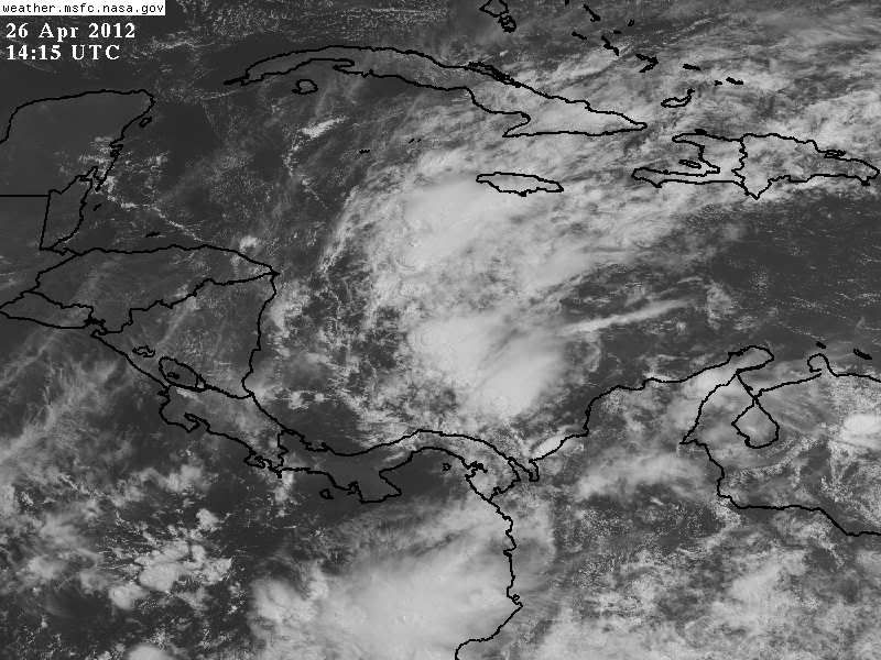
This is the current disturbance that will give some wet weather from Cuba to the Bahamas to possibly S FL over the next few days.
http://i20.photobucket.com/albums/b245/ ... PkDrBT.jpg
Users browsing this forum: No registered users and 53 guests

