Global model runs discussion

Moderator: S2k Moderators

Message
Author
User avatar
cycloneye
Admin
Admin
Posts: 139602
Age: 67
Joined: Thu Oct 10, 2002 10:54 am
Location: San Juan, Puerto Rico

Re: Global Model Runs Discussion

#3361 Postby cycloneye » Sat May 12, 2012 11:43 am

GFS continues to develop the Western Caribbean area,this is on day 7.

Image

On day 10 it crosses Cuba towards the Bahamas.

Image
0 likes   
Visit the Caribbean-Central America Weather Thread where you can find at first post web cams,radars
and observations from Caribbean basin members Click Here

User avatar
weatherwindow
Category 4
Category 4
Posts: 904
Joined: Mon Sep 20, 2004 9:48 am
Location: key west/ft lauderdale

Re: Global Model Runs Discussion

#3362 Postby weatherwindow » Sat May 12, 2012 1:50 pm

Things are getting interesting....at 240 hrs...the Canadian, the Euro and the GFS....have a low pressure system in the northwestern caribbean with mslp of 999, 1010 and 1002mbs respectively(http://www.raleighwx.americanwx.com). Let's just say the possibility of a tropical system moving toward cuba and the florida straits is becoming more realistic. Certainly not anything to assign a probability to but moving into the realm of the realistic....rich
0 likes   

psyclone
S2K Supporter
S2K Supporter
Posts: 4510
Joined: Wed Aug 24, 2005 9:04 pm
Location: palm harbor fl

#3363 Postby psyclone » Sat May 12, 2012 2:32 pm

Considering the extent to which most of Florida is moisture starved, i am hopeful something forms. even if it's not a named entity, a slug of tropical moisture to generate heavy rainfall would be a blessing.
0 likes   

WeatherWiseGuy
Tropical Depression
Tropical Depression
Posts: 92
Joined: Sat Jul 23, 2005 7:48 pm
Location: Florida

Re: Global Model Runs Discussion

#3364 Postby WeatherWiseGuy » Sat May 12, 2012 2:37 pm

I don't know. I'm not sure temperatures in the Caribbean are there yet. Seems a bit too early this year.
0 likes   

User avatar
weatherwindow
Category 4
Category 4
Posts: 904
Joined: Mon Sep 20, 2004 9:48 am
Location: key west/ft lauderdale

Re: Global Model Runs Discussion

#3365 Postby weatherwindow » Sat May 12, 2012 2:55 pm

WeatherWiseGuy wrote:I don't know. I'm not sure temperatures in the Caribbean are there yet. Seems a bit too early this year.

As a rule, ssts in the northwestern and southwestern caribbean are above the 26.5deg C threshold year-round. Currently they are approximately 27-28deg C. That shouldnt be a constraint. Shear is the crutical factor here.
0 likes   

Dean4Storms
S2K Supporter
S2K Supporter
Posts: 6356
Age: 61
Joined: Sun Aug 31, 2003 1:01 pm
Location: Miramar Bch. FL

#3366 Postby Dean4Storms » Sat May 12, 2012 7:07 pm

Lets hope that whatever develops there that it moves northward into the eastern Gulf. For one I don't believe it would become too deep a system due to the cooler waters and secondly, FL would be in the moisture and receive lots of rain!
0 likes   

User avatar
cycloneye
Admin
Admin
Posts: 139602
Age: 67
Joined: Thu Oct 10, 2002 10:54 am
Location: San Juan, Puerto Rico

Re: Global Model Runs Discussion

#3367 Postby cycloneye » Sun May 13, 2012 7:04 am

To not post all the graphics of the models,here is a brief summary of the 00z package.

GFS=The most agressive on Western Caribbean Development as it develops into a Tropical Storm.
ECMWF=Broad low Pressure but without developing.
NOGAPS=Nothing.
CMC=Nothing.

In other words,is not a stone yet that development will take place,but at least,we will see increasing convection by next weekend,and is a matter of waiting to see if the models reach a consensus or not in the next runs. If this does not develop,what about moisture going to the SE U.S that needs it badly? :)
0 likes   
Visit the Caribbean-Central America Weather Thread where you can find at first post web cams,radars
and observations from Caribbean basin members Click Here

User avatar
NDG
S2K Supporter
S2K Supporter
Posts: 14947
Joined: Sun Jul 09, 2006 10:14 pm
Location: Orlando, FL

#3368 Postby NDG » Sun May 13, 2012 8:43 am

:uarrow: CMC shows development in EPAC then moves it eastward towards C.A. with the energy redeloping in the western Carib in its 8-10 day range.

Image
0 likes   

User avatar
weatherwindow
Category 4
Category 4
Posts: 904
Joined: Mon Sep 20, 2004 9:48 am
Location: key west/ft lauderdale

Re: Global Model Runs Discussion

#3369 Postby weatherwindow » Sun May 13, 2012 9:33 am

cycloneye wrote:To not post all the graphics of the models,here is a brief summary of the 00z package.

GFS=The most agressive on Western Caribbean Development as it develops into a Tropical Storm.
ECMWF=Broad low Pressure but without developing.
NOGAPS=Nothing.
CMC=Nothing.

In other words,is not a stone yet that development will take place,but at least,we will see increasing convection by next weekend,and is a matter of waiting to see if the models reach a consensus or not in the next runs. If this does not develop,what about moisture going to the SE U.S that needs it badly? :)

Luis, think you missed something on 00Z GGEM(longrange CMC)....it has a 1005mb low, just north of the Bay Islands of Honduras at 204hrs. moves this low to the vicinity of the Caymans at 240hrs, 1003mb
0 likes   

Dean4Storms
S2K Supporter
S2K Supporter
Posts: 6356
Age: 61
Joined: Sun Aug 31, 2003 1:01 pm
Location: Miramar Bch. FL

Re: Global Model Runs Discussion

#3370 Postby Dean4Storms » Sun May 13, 2012 9:56 am

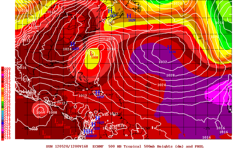
ECMWF with a strong closed low off the Carolina Coast at 168hrs..........


http://moe.met.fsu.edu/cgi-bin/ecmwf-op ... =Animation
0 likes   

User avatar
Hurricane Andrew
S2K Supporter
S2K Supporter
Posts: 1891
Age: 25
Joined: Sun May 23, 2010 2:53 pm
Location: KS

Re: Global Model Runs Discussion

#3371 Postby Hurricane Andrew » Sun May 13, 2012 12:20 pm

0 likes   

The Enthusiast
NREMT-AEMT, WX nerd

Irene '11, Sandy '12, Irma '17 (SAR)

"Hard to think we were born to live this way..." -Wage War

User avatar
Ivanhater
Storm2k Moderator
Storm2k Moderator
Posts: 10859
Age: 37
Joined: Fri Jul 01, 2005 8:25 am
Location: Pensacola

Re: Global Model Runs Discussion

#3372 Postby Ivanhater » Sun May 13, 2012 12:41 pm

Getting interesting....12z Gfs shows developing 6 days out

Image

Uploaded with ImageShack.us

Eventually hitting SoFlo

Image

Uploaded with ImageShack.us
0 likes   
Michael

User avatar
NDG
S2K Supporter
S2K Supporter
Posts: 14947
Joined: Sun Jul 09, 2006 10:14 pm
Location: Orlando, FL

#3373 Postby NDG » Sun May 13, 2012 2:09 pm

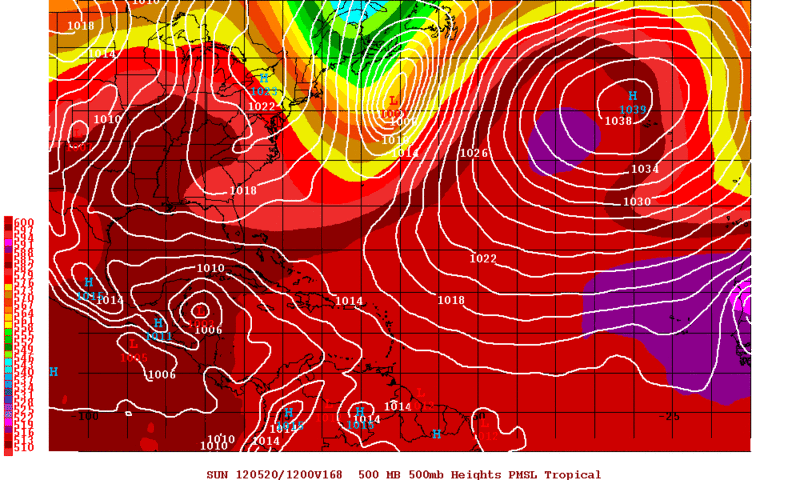
IMO, the GFS has development in the western Caribbean while the ECMWF has it in the eastern Pacific, for days the Euro has a trough of low pressure to dig down east off of the SE US and getting it cut off, pushing any disturbance south into the eastern Pac, while the GFS's solutions have been of a less amplified & more progressive trough in the eastern US.
The ECMWF loves cutting off troughs erroneously, so for now I am going more along with the GFS.

12z ECMWF
Image

12z GFS
Image
0 likes   

OuterBanker
S2K Supporter
S2K Supporter
Posts: 1706
Joined: Wed Feb 26, 2003 10:53 am
Location: Nags Head, NC
Contact:

Re: Global Model Runs Discussion

#3374 Postby OuterBanker » Sun May 13, 2012 2:58 pm

Geeze Andrew, that's a rather nasty scenario on the 12z GFS. A coast hugger then a loop back. Sure hope that one doesn't come true.

It sure has been quiet here this year, no noreasters, etc. No winter either. Is that a warm core system?
0 likes   

User avatar
Nimbus
Category 5
Category 5
Posts: 4933
Joined: Mon Jul 19, 2004 10:54 am

Re: Global Model Runs Discussion

#3375 Postby Nimbus » Sun May 13, 2012 5:07 pm

6 days out and we are getting closer to the hurricane season so.. maybe something tropical at least an invest. What are the shear forecasts saying? Wind shear often quells early season disturbances.
0 likes   

Ntxw
Storm2k Moderator
Storm2k Moderator
Posts: 21565
Joined: Wed Oct 21, 2009 6:34 pm
Location: DFW, Texas

Re: Global Model Runs Discussion

#3376 Postby Ntxw » Sun May 13, 2012 5:21 pm

Nimbus wrote:6 days out and we are getting closer to the hurricane season so.. maybe something tropical at least an invest. What are the shear forecasts saying? Wind shear often quells early season disturbances.


Here is the latest map for shear.

Image

At this time the Carib and gulf is hostile and not likely to sustain anything that forms, but that doesn't mean it will remain that way. We'll have to see, a week out is a long time. The EPAC however has pockets of low shear.
0 likes   
The above post and any post by Ntxw is NOT an official forecast and should not be used as such. It is just the opinion of the poster and may or may not be backed by sound meteorological data. It is NOT endorsed by any professional institution including Storm2k. For official information, please refer to NWS products.

  Help support Storm2K!
Help Support Storm2K

User avatar
cycloneye
Admin
Admin
Posts: 139602
Age: 67
Joined: Thu Oct 10, 2002 10:54 am
Location: San Juan, Puerto Rico

Re: Global Model Runs Discussion

#3377 Postby cycloneye » Sun May 13, 2012 6:24 pm

The consistency of GFS is remarkable regarding the development of this area in the Western Caribbean. The 18z run doesn't budge at all and has it a strong storm near Cuba in ten days. I would like to see the EURO with this to have more consensus among the models.

Image
0 likes   
Visit the Caribbean-Central America Weather Thread where you can find at first post web cams,radars
and observations from Caribbean basin members Click Here

User avatar
ROCK
Category 5
Category 5
Posts: 9254
Age: 53
Joined: Tue Aug 17, 2004 7:30 am
Location: Kemah, Texas

Re: Global Model Runs Discussion

#3378 Postby ROCK » Sun May 13, 2012 7:15 pm

there is some potential out there for sure. Not sure shear is going to let up in the next week. I would like to see the EURO a little more bullish before I jump on the bandwagon.

http://wxmaps.org/pix/hurpot.html#ATL
0 likes   

User avatar
SFLcane
S2K Supporter
S2K Supporter
Posts: 9627
Age: 46
Joined: Sat Jun 05, 2010 1:44 pm
Location: Lake Worth Florida

Re: Global Model Runs Discussion

#3379 Postby SFLcane » Sun May 13, 2012 7:50 pm

Crazy model! Still think This is more then likely convective feedback.
0 likes   

User avatar
boca
Category 5
Category 5
Posts: 6306
Age: 59
Joined: Mon Dec 15, 2003 8:49 am
Location: Boca Raton,FL

Re: Global Model Runs Discussion

#3380 Postby boca » Sun May 13, 2012 7:55 pm

Were all chasing a phantom storm.Which is interesting but i don't believe it.
0 likes   


Return to “2015”

Who is online

Users browsing this forum: No registered users and 9 guests