WPAC: KILO - Post-Tropical

Moderator: S2k Moderators

Message
Author
Alyono
Professional-Met
Professional-Met
Posts: 6961
Joined: Fri Apr 26, 2013 3:52 pm
Location: Texas Coast

Re: CPAC: KILO - Tropical Depression

#381 Postby Alyono » Sat Aug 22, 2015 3:04 pm

Blown Away wrote::uarrow:
Wow that would be historic... GFDL has a history of overdoing things...


nearly every model blows this up once it turns NE
0 likes   

TheStormExpert

#382 Postby TheStormExpert » Sat Aug 22, 2015 3:07 pm

18z Model Guidance :darrow:

Image

18z Intensity Guidance :darrow:

Image
0 likes   

User avatar
Yellow Evan
Professional-Met
Professional-Met
Posts: 16058
Age: 26
Joined: Fri Jul 15, 2011 12:48 pm
Location: Henderson, Nevada/Honolulu, HI
Contact:

Re:

#383 Postby Yellow Evan » Sat Aug 22, 2015 3:08 pm

Kingarabian wrote:Yeah I've been looking at the HWRF and GFDL. I think they need to be thrown out as well. Kilo is barely classifiable.


They are initializing properly it seems. And they don't do much with this for another 24 hours.

Probs best to go with the GFDL/HWRF for track and GFS/ECMWF for intensity.
0 likes   

Alyono
Professional-Met
Professional-Met
Posts: 6961
Joined: Fri Apr 26, 2013 3:52 pm
Location: Texas Coast

#384 Postby Alyono » Sat Aug 22, 2015 3:46 pm

just thinking

Iwa may be a better analog for this than Iniki
0 likes   

User avatar
Yellow Evan
Professional-Met
Professional-Met
Posts: 16058
Age: 26
Joined: Fri Jul 15, 2011 12:48 pm
Location: Henderson, Nevada/Honolulu, HI
Contact:

Re:

#385 Postby Yellow Evan » Sat Aug 22, 2015 3:49 pm

Alyono wrote:just thinking

Iwa may be a better analog for this than Iniki


Agreed, but likely stronger.
0 likes   

User avatar
Kingarabian
S2K Supporter
S2K Supporter
Posts: 15827
Joined: Sat Aug 08, 2009 3:06 am
Location: Honolulu, Hawaii

#386 Postby Kingarabian » Sat Aug 22, 2015 3:51 pm

The synoptic mission should be going on now, right?
0 likes   
RIP Kobe Bryant

User avatar
Yellow Evan
Professional-Met
Professional-Met
Posts: 16058
Age: 26
Joined: Fri Jul 15, 2011 12:48 pm
Location: Henderson, Nevada/Honolulu, HI
Contact:

Re:

#387 Postby Yellow Evan » Sat Aug 22, 2015 3:55 pm

Kingarabian wrote:The synoptic mission should be going on now, right?


AFAIK yes. Should help the 0z ECMWF/GFS runs, though I don't know which ridge they're investigating.
0 likes   

User avatar
Yellow Evan
Professional-Met
Professional-Met
Posts: 16058
Age: 26
Joined: Fri Jul 15, 2011 12:48 pm
Location: Henderson, Nevada/Honolulu, HI
Contact:

Re: CPAC: KILO - Tropical Depression

#388 Postby Yellow Evan » Sat Aug 22, 2015 4:24 pm

Image
0 likes   

Alyono
Professional-Met
Professional-Met
Posts: 6961
Joined: Fri Apr 26, 2013 3:52 pm
Location: Texas Coast

#389 Postby Alyono » Sat Aug 22, 2015 4:33 pm

reminding me of Fay. Vigorous in the mid levels. Nothing at the surface.

The issue with pulling the plug is this will likely redevelop by Monday
0 likes   

User avatar
srainhoutx
S2K Supporter
S2K Supporter
Posts: 6919
Age: 67
Joined: Sun Jan 14, 2007 11:34 am
Location: Haywood County, NC
Contact:

Re:

#390 Postby srainhoutx » Sat Aug 22, 2015 4:35 pm

Kingarabian wrote:The synoptic mission should be going on now, right?


AF 304 that flew out to Kilo this morning is currently W of Lihue/Kauai flying the synoptic mission. Getting a breezy tropical shower on Waikiki Beach at this time as well.
0 likes   
Carla/Alicia/Jerry(In The Eye)/Michelle/Charley/Ivan/Dennis/Katrina/Rita/Wilma/Ike/Harvey

Member: National Weather Association
Wx Infinity Forums
http://wxinfinity.com/index.php

Facebook.com/WeatherInfinity
Twitter @WeatherInfinity

Alyono
Professional-Met
Professional-Met
Posts: 6961
Joined: Fri Apr 26, 2013 3:52 pm
Location: Texas Coast

#391 Postby Alyono » Sat Aug 22, 2015 4:36 pm

18Z MU already too far west after just 9 hours
0 likes   

Alyono
Professional-Met
Professional-Met
Posts: 6961
Joined: Fri Apr 26, 2013 3:52 pm
Location: Texas Coast

#392 Postby Alyono » Sat Aug 22, 2015 4:39 pm

Fix your model, Uccellini. Kilo is not going to move 20 kts during the next 12 hours
0 likes   

User avatar
Yellow Evan
Professional-Met
Professional-Met
Posts: 16058
Age: 26
Joined: Fri Jul 15, 2011 12:48 pm
Location: Henderson, Nevada/Honolulu, HI
Contact:

#393 Postby Yellow Evan » Sat Aug 22, 2015 4:43 pm

WTPA41 PHFO 222044
TCDCP1

TROPICAL DEPRESSION KILO DISCUSSION NUMBER 9
NWS CENTRAL PACIFIC HURRICANE CENTER HONOLULU HI CP032015
1100 AM HST SAT AUG 22 2015

U.S. AIR FORCE RESERVE RECONNAISSANCE FOUND MAXIMUM FLIGHT LEVEL
WINDS OF 30 KT ON THE APPROACH INTO KILO THIS MORNING...WHICH IS THE
BASIS FOR MAINTAINING THE INITIAL INTENSITY OF 25 KT. ALTHOUGH
SATELLITE IMAGERY IS SHOWING PERSISTENT VIGOROUS DEEP CONVECTION TO
THE WEST OF THE APPARENT LOW LEVEL CENTER...THE AIRCRAFT WAS UNABLE
TO MAKE A SECOND FIX ON THE CENTER. IN ADDITION...A 1745 UTC SSMIS
PASS SUGGESTED ANOTHER CENTER MAY BE A LITTLE FARTHER TO THE
NORTHEAST...ALONG WITH A RATHER ELONGATED PATTERN OF LOW CLOUDS
AROUND KILO. ALL OF THIS CONTINUES TO INDICATE THAT...FOR THE
MOMENT...KILO REMAINS SOMEWHAT DISORGANIZED.

THE INITIAL MOTION ESTIMATE IS 295/13. A MID LEVEL ANTICYCLONE TO
THE SOUTHEAST OF HAWAII IS CONTINUING TO STEER THE DEPRESSION
TOWARD THE WEST-NORTHWEST. GLOBAL MODELS SHOW THE RIDGE WHICH
EXTENDS TO THE WEST OF THIS ANTICYCLONE WILL GRADUALLY WEAKEN OVER
THE NEXT FEW DAYS...PUTTING KILO IN A PERSISTENT AREA OF VERY WEAK
STEERING. THE FORECAST THUS SHOWS A SIGNIFICANT SLOWING OF THE
WEST-NORTHWEST MOTION BY DAY 3. BEYOND DAY 3...A SLOW MOTION TOWARD
THE NORTHEAST IS EXPECTED AS KILO STARTS TO FEEL THE INFLUENCE OF A
MID-TO-UPPER LEVEL TROUGH LOCATED NORTH OF HAWAII. THE OFFICIAL
FORECAST IS VERY CLOSE TO THE PREVIOUS FORECAST THROUGH ABOUT 72
HOURS...THEN INDICATES A SLOWER FORWARD MOTION AT DAYS 4 AND 5...TO
BE IN BETTER AGREEMENT WITH THE CONSENSUS MODELS.

ALTHOUGH KILO HAS BEEN STRUGGLING TO ORGANIZE THUS FAR...THE
ENVIRONMENT CERTAINLY APPEARS TO BE CONDUCIVE FOR STRENGTHENING.
THE FORECAST TRACK TAKES KILO OVER SEA SURFACE TEMPERATURES OF
28-29C AND RELATIVELY WEAK SHEAR AS KILO MOVES TOWARD...AND THEN
REMAINS NEARLY STATIONARY UNDERNEATH AN UPPER LEVEL RIDGE AXIS. THE
INTENSITY FORECAST HAS BEEN NUDGED SLIGHTLY HIGHER TO BE IN BETTER
AGREEMENT WITH THE SHIPS GUIDANCE...BUT STILL WELL BELOW THE MORE
AGGRESSIVE GFDL AND HWRF.


FORECAST POSITIONS AND MAX WINDS

INIT 22/2100Z 14.2N 159.4W 25 KT 30 MPH
12H 23/0600Z 14.9N 161.4W 30 KT 35 MPH
24H 23/1800Z 16.0N 163.6W 35 KT 40 MPH
36H 24/0600Z 16.8N 164.5W 40 KT 45 MPH
48H 24/1800Z 17.6N 164.8W 45 KT 50 MPH
72H 25/1800Z 18.9N 164.3W 55 KT 65 MPH
96H 26/1800Z 19.4N 163.7W 65 KT 75 MPH
120H 27/1800Z 20.0N 163.0W 75 KT 85 MPH

$$
FORECASTER R BALLARD
0 likes   

User avatar
Yellow Evan
Professional-Met
Professional-Met
Posts: 16058
Age: 26
Joined: Fri Jul 15, 2011 12:48 pm
Location: Henderson, Nevada/Honolulu, HI
Contact:

Re:

#394 Postby Yellow Evan » Sat Aug 22, 2015 4:44 pm

Alyono wrote: The issue with pulling the plug is this will likely redevelop by Monday


I agree it's not worth pulling the plug unless we get more confirmation, but you never know what the CPHC will do.
0 likes   

User avatar
srainhoutx
S2K Supporter
S2K Supporter
Posts: 6919
Age: 67
Joined: Sun Jan 14, 2007 11:34 am
Location: Haywood County, NC
Contact:

Re: CPAC: KILO - Tropical Depression

#395 Postby srainhoutx » Sat Aug 22, 2015 4:56 pm

The CHPC is being very cautious with Kilo. Don't look for them to 'pull the plug' anytime soon with the guidance suggesting a stall and re curve back toward Hawaii. The Hotels are very near 100% occupied on Oahu alone and the local folks are very aware that a storm is brewing to the S. It has been the topic of discussion by the staff all morning. In fact, most everyone that talked to me so far today are getting their Hurricane supplies this afternoon or tomorrow. I was actually surprised that many have been asking me what is the latest and wanting to see the satellite imagery on my android... :wink: It will be interesting to see if the area NE of the main convection becomes a more dominate surface low. It appears via looped VIS imagery and HIRES 1 km zoomed imagery that a more northerly motion is beginning. Look at the 'notched' area N of 14N on the image below.

Image
0 likes   
Carla/Alicia/Jerry(In The Eye)/Michelle/Charley/Ivan/Dennis/Katrina/Rita/Wilma/Ike/Harvey

Member: National Weather Association
Wx Infinity Forums
http://wxinfinity.com/index.php

Facebook.com/WeatherInfinity
Twitter @WeatherInfinity

User avatar
Yellow Evan
Professional-Met
Professional-Met
Posts: 16058
Age: 26
Joined: Fri Jul 15, 2011 12:48 pm
Location: Henderson, Nevada/Honolulu, HI
Contact:

#396 Postby Yellow Evan » Sat Aug 22, 2015 5:02 pm

18z GFS quite similar to the 12z expect a little more NNW through 72 hours. Starts to intesfyin this late Monday/early Tuesday.
0 likes   

User avatar
Yellow Evan
Professional-Met
Professional-Met
Posts: 16058
Age: 26
Joined: Fri Jul 15, 2011 12:48 pm
Location: Henderson, Nevada/Honolulu, HI
Contact:

Re: CPAC: KILO - Tropical Depression

#397 Postby Yellow Evan » Sat Aug 22, 2015 5:09 pm

Image

Through 108 hours
0 likes   

User avatar
Kingarabian
S2K Supporter
S2K Supporter
Posts: 15827
Joined: Sat Aug 08, 2009 3:06 am
Location: Honolulu, Hawaii

Re: CPAC: KILO - Tropical Depression

#398 Postby Kingarabian » Sat Aug 22, 2015 5:17 pm

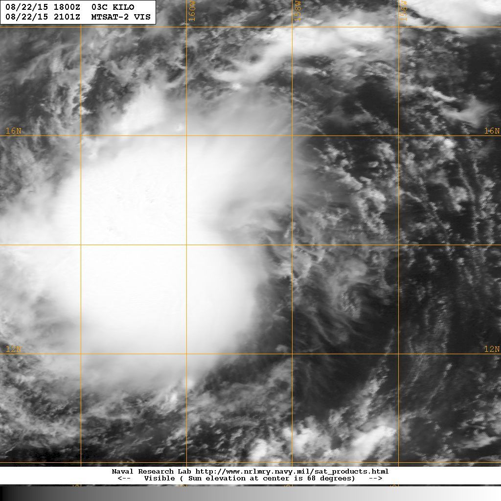
srainhoutx wrote:The CHPC is being very cautious with Kilo. Don't look for them to 'pull the plug' anytime soon with the guidance suggesting a stall and re curve back toward Hawaii. The Hotels are very near 100% occupied on Oahu alone and the local folks are very aware that a storm is brewing to the S. It has been the topic of discussion by the staff all morning. In fact, most everyone that talked to me so far today are getting their Hurricane supplies this afternoon or tomorrow. I was actually surprised that many have been asking me what is the latest and wanting to see the satellite imagery on my android... :wink: It will be interesting to see if the area NE of the main convection becomes a more dominate surface low. It appears via looped VIS imagery and HIRES 1 km zoomed imagery that a more northerly motion is beginning. Look at the 'notched' area N of 14N on the image below.


I'm glad they're taking heed and preparing.

Right now I have a lot of cases of water, canned goods, batteries, and toilet paper. I'm going to wait on the 00z Euro and GFS runs and see what they show. If they continue showing what they're currently showing, I'm going to head to The Home Depot tomorrow and buy some plywood to board up my house.
0 likes   
RIP Kobe Bryant

TheStormExpert

#399 Postby TheStormExpert » Sat Aug 22, 2015 5:32 pm

Yeah tonight's 00z model runs SHOULD tell the story of whether the threat to Hawaii is high or lessening. Still even bare minimal effects from a TS can cause SERIOUS issues to these Islands since they're not used to these storms.
0 likes   

User avatar
Yellow Evan
Professional-Met
Professional-Met
Posts: 16058
Age: 26
Joined: Fri Jul 15, 2011 12:48 pm
Location: Henderson, Nevada/Honolulu, HI
Contact:

#400 Postby Yellow Evan » Sat Aug 22, 2015 6:03 pm

18z GFS actually still takes this west as they end up re-deepening the ridge.
0 likes   


Return to “2015”

Who is online

Users browsing this forum: No registered users and 33 guests