Global model runs discussion
Moderator: S2k Moderators
-
Aric Dunn
- Category 5

- Posts: 21238
- Age: 43
- Joined: Sun Sep 19, 2004 9:58 pm
- Location: Ready for the Chase.
- Contact:
Yeah 12z Euro very interesting. not sure of the motion. depends on how far north it exits the coast.
0 likes
Note: If I make a post that is brief. Please refer back to previous posts for the analysis or reasoning. I do not re-write/qoute what my initial post said each time.
If there is nothing before... then just ask
Space & Atmospheric Physicist, Embry-Riddle Aeronautical University,
I believe the sky is falling...
If there is nothing before... then just ask
Space & Atmospheric Physicist, Embry-Riddle Aeronautical University,
I believe the sky is falling...
-
Aric Dunn
- Category 5
- Posts: 21238
- Age: 43
- Joined: Sun Sep 19, 2004 9:58 pm
- Location: Ready for the Chase.
- Contact:
Also the gfs has a piece of the energy from TD7 move into the BOC then drift north and develops it and takes into bownsville.
http://mag.ncep.noaa.gov/NCOMAGWEB/appc ... mageSize=M
http://mag.ncep.noaa.gov/NCOMAGWEB/appc ... mageSize=M
0 likes
Note: If I make a post that is brief. Please refer back to previous posts for the analysis or reasoning. I do not re-write/qoute what my initial post said each time.
If there is nothing before... then just ask
Space & Atmospheric Physicist, Embry-Riddle Aeronautical University,
I believe the sky is falling...
If there is nothing before... then just ask
Space & Atmospheric Physicist, Embry-Riddle Aeronautical University,
I believe the sky is falling...
-
Aric Dunn
- Category 5
- Posts: 21238
- Age: 43
- Joined: Sun Sep 19, 2004 9:58 pm
- Location: Ready for the Chase.
- Contact:
Re: Global Model Runs Discussion
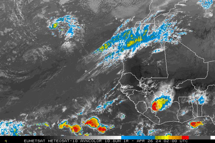
there it is over africa....
0 likes
Note: If I make a post that is brief. Please refer back to previous posts for the analysis or reasoning. I do not re-write/qoute what my initial post said each time.
If there is nothing before... then just ask
Space & Atmospheric Physicist, Embry-Riddle Aeronautical University,
I believe the sky is falling...
If there is nothing before... then just ask
Space & Atmospheric Physicist, Embry-Riddle Aeronautical University,
I believe the sky is falling...

Re: Global Model Runs Discussion
Aric Dunn wrote:there it is over africa....
[img][/img]
That looks downright nasty.
0 likes
-
HurricaneFan
- Tropical Storm

- Posts: 192
- Age: 42
- Joined: Tue Jan 18, 2011 6:16 pm
- Location: Anguilla,Leeward Islands 18.3N 63.0W
Re:
Aric Dunn wrote:Yeah 12z Euro very interesting. not sure of the motion. depends on how far north it exits the coast.
Do you mean that it can possibly make it across to the Lesser Antilles?
An earlier run by the Euro was showing that a few days ago,but of course the models have been quite inconsistent lately.
0 likes

Re: Global Model Runs Discussion
lets see where it splashes down.....further south not for certain a fish storm.....it is impressive for being over land..
0 likes
-
Blown Away

- S2K Supporter

- Posts: 10253
- Joined: Wed May 26, 2004 6:17 am
Re: Global Model Runs Discussion
06z GFS: http://raleighwx.americanwx.com/models/gfs/06zgfstropical850mbVortSLPGFSLoop.html

384 Hours
Big boy or girl moving across the Atlantic at 384 hours.
384 Hours
Big boy or girl moving across the Atlantic at 384 hours.
Last edited by Blown Away on Wed Aug 15, 2012 10:22 am, edited 1 time in total.
0 likes
Hurricane Eye Experience: David 79, Irene 99, Frances 04, Jeanne 04, Wilma 05… Hurricane Brush Experience: Andrew 92, Erin 95, Floyd 99, Matthew 16, Irma 17, Ian 22, Nicole 22…
-
Blown Away
- S2K Supporter
- Posts: 10253
- Joined: Wed May 26, 2004 6:17 am
Re: Global Model Runs Discussion
06 GFS: 240 Hours: http://raleighwx.americanwx.com/models/ ... SLoop.html

12z Euro: 240 Hours: http://raleighwx.americanwx.com/models/ ... _loop.html

At 240 hours, the Euro has a deeper low moving across the Atlantic and begins to recurve well east of the islands. The GFS has the same low not as deep moving across the Atlantic, degenerates into a wave and moves over the NE Caribbean islands, and finally this wave crosses the Florida peninsula. I think our wave just off Africa is the one the models are picking up on. The GFS is seeing a pattern that could bring this area towards the islands and CONUS. Just a wait and see now!
12z Euro: 240 Hours: http://raleighwx.americanwx.com/models/ ... _loop.html
At 240 hours, the Euro has a deeper low moving across the Atlantic and begins to recurve well east of the islands. The GFS has the same low not as deep moving across the Atlantic, degenerates into a wave and moves over the NE Caribbean islands, and finally this wave crosses the Florida peninsula. I think our wave just off Africa is the one the models are picking up on. The GFS is seeing a pattern that could bring this area towards the islands and CONUS. Just a wait and see now!
0 likes
Hurricane Eye Experience: David 79, Irene 99, Frances 04, Jeanne 04, Wilma 05… Hurricane Brush Experience: Andrew 92, Erin 95, Floyd 99, Matthew 16, Irma 17, Ian 22, Nicole 22…
-
Aric Dunn
- Category 5
- Posts: 21238
- Age: 43
- Joined: Sun Sep 19, 2004 9:58 pm
- Location: Ready for the Chase.
- Contact:
its seems awfully low latitude right now over africa... dont think it will head NW. the weakness maybe not so large. noticed the gfs now keeps it west and the euro not so much of a recurve.
0 likes
Note: If I make a post that is brief. Please refer back to previous posts for the analysis or reasoning. I do not re-write/qoute what my initial post said each time.
If there is nothing before... then just ask
Space & Atmospheric Physicist, Embry-Riddle Aeronautical University,
I believe the sky is falling...
If there is nothing before... then just ask
Space & Atmospheric Physicist, Embry-Riddle Aeronautical University,
I believe the sky is falling...
-
HurricaneWarning92
- Category 2

- Posts: 520
- Joined: Sat Jul 23, 2011 4:33 pm
- Location: Pembroke Pines, S. Florida (Lat: 26.00N, Lon: 80.22W)
All of a sudden now things got interesting...
0 likes
The posts in this forum are NOT official forecast and should not be used as such. They are just the opinion of the poster and may or may not be backed by sound meteorological data. They are NOT endorsed by any professional institution or storm2k.org. For official information, please refer to the NHC and NWS products.

Tropical wave coming off Africa in 6-7 days
I read in a blog that a tropical wave is supposed to come off Africa in 6 to 7 days and that several models are predicting development. Will someone please direct me to those models or to some further information about this wave?
Thank you.
Thank you.
0 likes
-
Blown Away
- S2K Supporter
- Posts: 10253
- Joined: Wed May 26, 2004 6:17 am
Re: Global Model Runs Discussion
12z GFS: http://raleighwx.americanwx.com/models/ ... SLoop.html
That big buzz saw moving across the Atlantic near the end run I believe is the wave you are referring to!
Last edited by Blown Away on Wed Aug 15, 2012 2:33 pm, edited 2 times in total.
0 likes
Hurricane Eye Experience: David 79, Irene 99, Frances 04, Jeanne 04, Wilma 05… Hurricane Brush Experience: Andrew 92, Erin 95, Floyd 99, Matthew 16, Irma 17, Ian 22, Nicole 22…

Looks like a more zonal flow in the trade-winds with a weaker mid Atlantic TUTT. Moisture pushing west off Africa ahead of this area looks adequate and its the 15th of August so it has my attention.
Wish it were a little further north so it might recurve. Doubt this one will make a run for Mexico with the current setup.
Wish it were a little further north so it might recurve. Doubt this one will make a run for Mexico with the current setup.
0 likes
Re: Global Model Runs Discussion
Thank you, Blown Away, but I keep getting "File not found" at that address. Is there another way to see the information, or at least can you tell me where the buzz saw is headed in the end run.
Thank you1
Thank you1
0 likes
-
cycloneye

- Admin

- Posts: 149479
- Age: 69
- Joined: Thu Oct 10, 2002 10:54 am
- Location: San Juan, Puerto Rico
Re: Global Model Runs Discussion
The 12z ECMWF at 240 hours shows a little bit more west system than at the 00z.

0 likes
Visit the Caribbean-Central America Weather Thread where you can find at first post web cams,radars
and observations from Caribbean basin members Click Here
and observations from Caribbean basin members Click Here
-
Blown Away
- S2K Supporter
- Posts: 10253
- Joined: Wed May 26, 2004 6:17 am
Re: Global Model Runs Discussion
sunnyday wrote:Thank you, Blown Away, but I keep getting "File not found" at that address. Is there another way to see the information, or at least can you tell me where the buzz saw is headed in the end run.
Thank you1

The 384 position is the end, it was generally moving west until it reached the end of the run! Where it goes from there is unknown??
http://raleighwx.americanwx.com/models.html
This is where I go.
Last edited by Blown Away on Wed Aug 15, 2012 2:36 pm, edited 1 time in total.
0 likes
Hurricane Eye Experience: David 79, Irene 99, Frances 04, Jeanne 04, Wilma 05… Hurricane Brush Experience: Andrew 92, Erin 95, Floyd 99, Matthew 16, Irma 17, Ian 22, Nicole 22…
Re: Global Model Runs Discussion
Thank you! Let's hope this one doesn't come our way. Any thoughts on where you might guess (I know it's a long way off).
0 likes
-
Blown Away
- S2K Supporter
- Posts: 10253
- Joined: Wed May 26, 2004 6:17 am
Re: Global Model Runs Discussion
sunnyday wrote:Thank you! Let's hope this one doesn't come our way. Any thoughts on where you might guess (I know it's a long way off).
The Euro wants to recurve it east of the islands, but the latest Euro run was a little farther west, so who knows. EC trough seems persistent, but late August early September is go time, so we gotta watch!
MY PREDICTION: In about 9 days this wave will emerge off Africa and will become Major Hurricane Isaac. Isaac will generally move west across the Atlantic and just miss the NE Caribbean on it's way to Hobe Sound. Isaac will set the all time activity record on Storm2k!
Last edited by Blown Away on Wed Aug 15, 2012 4:08 pm, edited 1 time in total.
0 likes
Hurricane Eye Experience: David 79, Irene 99, Frances 04, Jeanne 04, Wilma 05… Hurricane Brush Experience: Andrew 92, Erin 95, Floyd 99, Matthew 16, Irma 17, Ian 22, Nicole 22…

If a system does manage to get further west (say past 60W) without recurving then the pattern I'm seeing in the models would suggest a possible threat. There is troughing but its quite weak and not the sort of angle that will scoop systems NE, but rather just shift the track to a NW/N direction. Same goes for the Gulf if anything manages to get into the Caribbean.
Models are all over the place at the moment.
Models are all over the place at the moment.
0 likes
Personal Forecast Disclaimer:
The posts in this forum are NOT official forecast and should not be used as such. They are just the opinion of the poster and may or may not be backed by sound meteorological data. They are NOT endorsed by any professional institution or storm2k.org. For official information, please refer to the NHC and NWS products
The posts in this forum are NOT official forecast and should not be used as such. They are just the opinion of the poster and may or may not be backed by sound meteorological data. They are NOT endorsed by any professional institution or storm2k.org. For official information, please refer to the NHC and NWS products
-
Hurricane Alexis

- Category 2
- Posts: 683
- Age: 29
- Joined: Thu Jun 14, 2012 7:59 pm
- Location: Miami,Florida
The 00z runs of the GFS and euro both show a cat 2/cat 3 fish storm recurving east of the lesser antilles and passing east of bermuda.
0 likes
Personal Forecast Disclaimer:
The posts in this forum are NOT official forecast and should not be used as such. They are just the opinion of the poster and may or may not be backed by sound meteorological data. They are NOT endorsed by any professional institution or storm2k.org. For official information, please refer to the NHC and NWS products.
The posts in this forum are NOT official forecast and should not be used as such. They are just the opinion of the poster and may or may not be backed by sound meteorological data. They are NOT endorsed by any professional institution or storm2k.org. For official information, please refer to the NHC and NWS products.
Who is online
Users browsing this forum: No registered users and 55 guests