Global model runs discussion
Moderator: S2k Moderators

Re: Global Model Runs Discussion
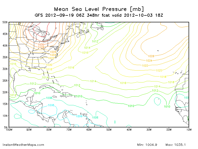
06z GFS shows W Carribean development in the long range. Let's see if the 12z shows it.
0 likes
The following post is NOT an official forecast and should not be used as such. It is just the opinion of the poster and may or may not be backed by sound meteorological data. It is NOT endorsed by any professional institution including storm2k.org For Official Information please refer to the NHC and NWS products.

Re: Global Model Runs Discussion
blp wrote:06z GFS shows W Carribean development in the long range. Let's see if the 12z shows it.
Here is the 06z GFS at 348 hrs:
0 likes
-
cycloneye

- Admin

- Posts: 149475
- Age: 69
- Joined: Thu Oct 10, 2002 10:54 am
- Location: San Juan, Puerto Rico
Re: Global Model Runs Discussion
12z GFS develops on long range a couple of systems,one in GOM and the other in Central Atlantic. Again,is very long range as those may not be there on next runs so very little confidence for now. However,the wet phase of MJO will arrive in the Caribbean by early to mid October and that could get things going in Western/SW Caribbean.

0 likes
Visit the Caribbean-Central America Weather Thread where you can find at first post web cams,radars
and observations from Caribbean basin members Click Here
and observations from Caribbean basin members Click Here
Re: Global Model Runs Discussion
TWC mentioned that indirectly this morning but their graphic was incorrect - it showed "suppressed thunderstorm activity" across Florida over the past couple of months - but it's been one of our rainiest summers in years, especially in South Florida...
Still, they did mentioned that "enhanced thunderstorm activity" is forecast to be over the western Caribbean by early October...
We'll see...
Still, they did mentioned that "enhanced thunderstorm activity" is forecast to be over the western Caribbean by early October...
We'll see...
0 likes
-
ConvergenceZone
.gif)
- Category 5

- Posts: 5241
- Joined: Fri Jul 29, 2005 1:40 am
- Location: Northern California
(Sarcasm mode on: I''m still waiting for the hurricanes that some posters mentioned that we should still have since we are "early in the season".....Been waiting for quite some time now, so how long do we need to wait again?  )
)
As I mentioned last month, I just don't see it..... I think the season will die early and I'm sticking with it, no matter how many people feel otherwise....We'll see if I'm right or wrong.
-------------------------------------------------------------------------
The following post is NOT an official forecast and should not be used as such. It is just the opinion of the poster and may or
may not be backed by sound meteorological data. It is NOT endorsed by any professional institution including storm2k.org For Official Information please refer to the NHC and NWS products.
0 likes
-
Dean4Storms
- S2K Supporter

- Posts: 6358
- Age: 63
- Joined: Sun Aug 31, 2003 1:01 pm
- Location: Miramar Bch. FL
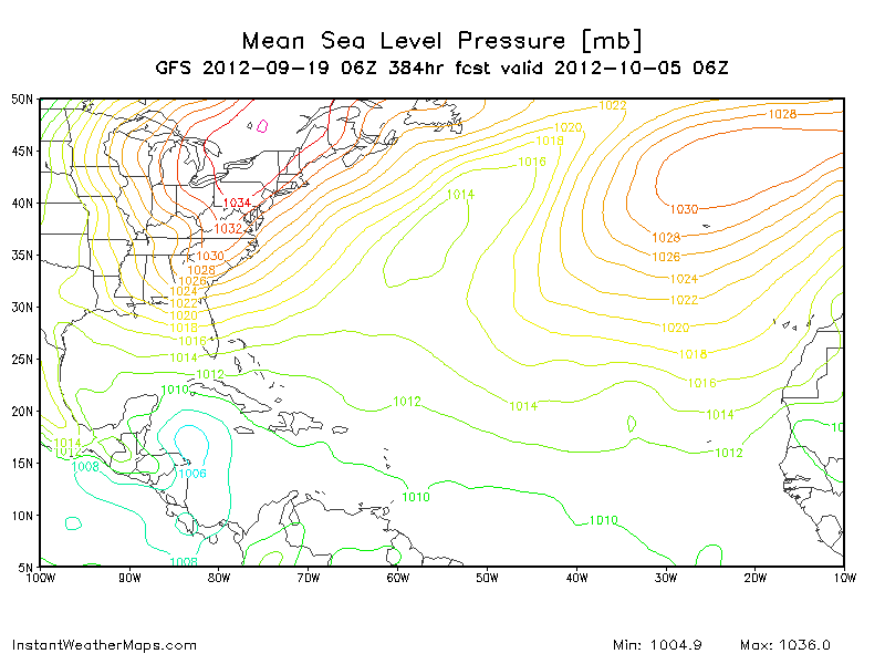
06z GFS developing a Tropical Storm around Cuba 6-8th of Oct. as a Low gets trapped under a strong East Coast Ridge.
http://raleighwx.americanwx.com/models/ ... SLoop.html
http://raleighwx.americanwx.com/models/ ... SLoop.html
0 likes
-
wxman57

- Moderator-Pro Met

- Posts: 23174
- Age: 68
- Joined: Sat Jun 21, 2003 8:06 pm
- Location: Houston, TX (southwest)
Re: Global Model Runs Discussion
cycloneye wrote:12z GFS develops on long range a couple of systems,one in GOM and the other in Central Atlantic. Again,is very long range as those may not be there on next runs so very little confidence for now. However,the wet phase of MJO will arrive in the Caribbean by early to mid October and that could get things going in Western/SW Caribbean.
http://oi48.tinypic.com/30nc3uw.jpg
I've found that those graphics
0 likes
-
cycloneye
- Admin
- Posts: 149475
- Age: 69
- Joined: Thu Oct 10, 2002 10:54 am
- Location: San Juan, Puerto Rico
Re: Global Model Runs Discussion
From Saturday's discussion about the rest of the 2012 North Atlantic season by Dr Jeff Masters.
We've been in a relatively quiet period in the Atlantic for over a week now, and the computer models predict that this quiet period will last at least another week. The quiet period is primarily due to the fact that the African Monsoon has been less active, and there are fewer tropical waves coming off the coast of Africa. Even the busiest hurricane season has quiet periods like this, and we should not assume that hurricane season is over. The first two weeks of October are typically a busy period for tropical cyclones in the Atlantic, and I expect that we'll see one or two more names storms in the Atlantic before October 15.
We've been in a relatively quiet period in the Atlantic for over a week now, and the computer models predict that this quiet period will last at least another week. The quiet period is primarily due to the fact that the African Monsoon has been less active, and there are fewer tropical waves coming off the coast of Africa. Even the busiest hurricane season has quiet periods like this, and we should not assume that hurricane season is over. The first two weeks of October are typically a busy period for tropical cyclones in the Atlantic, and I expect that we'll see one or two more names storms in the Atlantic before October 15.
0 likes
Visit the Caribbean-Central America Weather Thread where you can find at first post web cams,radars
and observations from Caribbean basin members Click Here
and observations from Caribbean basin members Click Here
-
cycloneye
- Admin
- Posts: 149475
- Age: 69
- Joined: Thu Oct 10, 2002 10:54 am
- Location: San Juan, Puerto Rico
Re: Global Model Runs Discussion
We have seen this before about GFS developing phanthom systems then being dropped by the model but this time it shows at 12z run a SW Caribbean development on long range. We know the drill about long range however, this time fits on the climatological favored area in October so let's see if the model continues with it and other models join.

0 likes
Visit the Caribbean-Central America Weather Thread where you can find at first post web cams,radars
and observations from Caribbean basin members Click Here
and observations from Caribbean basin members Click Here
-
HurricaneFan
- Tropical Storm

- Posts: 192
- Age: 42
- Joined: Tue Jan 18, 2011 6:16 pm
- Location: Anguilla,Leeward Islands 18.3N 63.0W
Re: Global Model Runs Discussion
What about the surface Low that the forecast from the CA/Carib thread forms south of PR into the upcoming weekend?
0 likes
-
cycloneye
- Admin
- Posts: 149475
- Age: 69
- Joined: Thu Oct 10, 2002 10:54 am
- Location: San Juan, Puerto Rico
Re: Global Model Runs Discussion
HurricaneFan wrote:What about the surface Low that the forecast from the CA/Carib thread forms south of PR into the upcoming weekend?
GFS has a low pressure in the Southern Caribbean in 144 hours but it not develop it. What it does is increase the moisture in the Eastern Caribbean.
http://oi48.tinypic.com/dzi901.jpg
0 likes
Visit the Caribbean-Central America Weather Thread where you can find at first post web cams,radars
and observations from Caribbean basin members Click Here
and observations from Caribbean basin members Click Here
Re: Global Model Runs Discussion
cycloneye wrote:We have seen this before about GFS developing phanthom systems then being dropped by the model but this time it shows at 12z run a SW Caribbean development on long range. We know the drill about long range however, this time fits on the climatological favored area in October so let's see if the model continues with it and other models join.
]http://oi45.tinypic.com/se62jb.jpg[/img]
18z drops it again. One thing I have noticed is that the GFS has been consistent the last 3 or 4 runs with Epac development. I wonder if the Epac development is taking away the energy for the W. Carribean development. The 12z did show development on both sides though. What I take from all of this is that the MJO pulse looks to be making a return to our region in two weeks and chances are going be good for something to get going.
0 likes
The following post is NOT an official forecast and should not be used as such. It is just the opinion of the poster and may or may not be backed by sound meteorological data. It is NOT endorsed by any professional institution including storm2k.org For Official Information please refer to the NHC and NWS products.
-
cycloneye
- Admin
- Posts: 149475
- Age: 69
- Joined: Thu Oct 10, 2002 10:54 am
- Location: San Juan, Puerto Rico
Re: Global Model Runs Discussion
blp wrote:cycloneye wrote:We have seen this before about GFS developing phanthom systems then being dropped by the model but this time it shows at 12z run a SW Caribbean development on long range. We know the drill about long range however, this time fits on the climatological favored area in October so let's see if the model continues with it and other models join.
]http://oi45.tinypic.com/se62jb.jpg[/img]
18z drops it again. One thing I have noticed is that the GFS has been consistent the last 3 or 4 runs with Epac development. I wonder if the Epac development is taking away the energy for the W. Carribean development. The 12z did show development on both sides though. What I take from all of this is that the MJO pulse looks to be making a return to our region in two weeks and chances are going be good for something to get going.
That is right about the MJO returning to the area of the Caribbean. What will be important to watch will be how the monsoon trough behaves and that may be key about which side has development.
0 likes
Visit the Caribbean-Central America Weather Thread where you can find at first post web cams,radars
and observations from Caribbean basin members Click Here
and observations from Caribbean basin members Click Here


I think a mid to late Oct storm is possible. The models could start picking it up early Oct.
0 likes
The above post and any post by Ntxw is NOT an official forecast and should not be used as such. It is just the opinion of the poster and may or may not be backed by sound meteorological data. It is NOT endorsed by any professional institution including Storm2k. For official information, please refer to NWS products.
Help support Storm2K!

-
cycloneye
- Admin
- Posts: 149475
- Age: 69
- Joined: Thu Oct 10, 2002 10:54 am
- Location: San Juan, Puerto Rico
Re: Global Model Runs Discussion
Long Range 00z GFS had development on both sides of CentralAmerica. It has gone back and forth in past runs between development at EPAC or Caribbean. But what may be certain is that the area is climatological favored and something may pop up so let's continue to watch the SW Caribbean in real time and to see if the models start to show development in less than 120 hours.
0 likes
Visit the Caribbean-Central America Weather Thread where you can find at first post web cams,radars
and observations from Caribbean basin members Click Here
and observations from Caribbean basin members Click Here
Man this is one of the quietest September (peak) I can remember on this board. Hopefully we can get a good fish storm going on the models to track soon.
0 likes
The above post and any post by Ntxw is NOT an official forecast and should not be used as such. It is just the opinion of the poster and may or may not be backed by sound meteorological data. It is NOT endorsed by any professional institution including Storm2k. For official information, please refer to NWS products.
Help support Storm2K!
Help support Storm2K!
-
cycloneye
- Admin
- Posts: 149475
- Age: 69
- Joined: Thu Oct 10, 2002 10:54 am
- Location: San Juan, Puerto Rico
Re: Global Model Runs Discussion
The 12z ECMWF has a storm moving torwards the Louisiana coast in 120 hours. GFS has also a low in BOC at that timeframe.

0 likes
Visit the Caribbean-Central America Weather Thread where you can find at first post web cams,radars
and observations from Caribbean basin members Click Here
and observations from Caribbean basin members Click Here
-
Hurricane Alexis

- Category 2

- Posts: 683
- Age: 29
- Joined: Thu Jun 14, 2012 7:59 pm
- Location: Miami,Florida
Re: Global Model Runs Discussion
cycloneye wrote:The 12z ECMWF has a storm moving torwards the Louisiana coast in 120 hours. GFS has also a low in BOC at that timeframe.
http://oi49.tinypic.com/9u24p3.jpg
It doesn't look tropical in nature, it might be associated with a front...maybe it's subtropical.
0 likes
Personal Forecast Disclaimer:
The posts in this forum are NOT official forecast and should not be used as such. They are just the opinion of the poster and may or may not be backed by sound meteorological data. They are NOT endorsed by any professional institution or storm2k.org. For official information, please refer to the NHC and NWS products.
The posts in this forum are NOT official forecast and should not be used as such. They are just the opinion of the poster and may or may not be backed by sound meteorological data. They are NOT endorsed by any professional institution or storm2k.org. For official information, please refer to the NHC and NWS products.
Who is online
Users browsing this forum: No registered users and 60 guests