Global model runs discussion

Moderator: S2k Moderators

Message
Author
User avatar
weatherwindow
Category 4
Category 4
Posts: 904
Joined: Mon Sep 20, 2004 9:48 am
Location: key west/ft lauderdale

Re: Global Model Runs Discussion

#4501 Postby weatherwindow » Fri Mar 15, 2013 6:19 pm

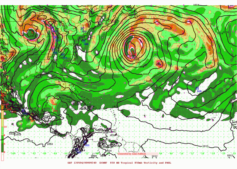
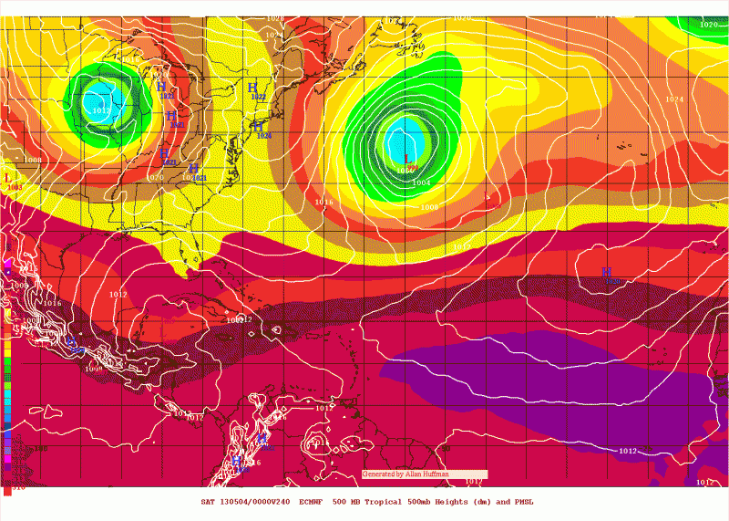
cycloneye wrote:The models have been showing a low pressure in the GOM moving NE towards Florida Penninsula for the past few runs. ECMWF is also showing at day 10. I think this is a non-tropical low but you never know if mother nature surprises us with a semi warm core


Good catch, Luis.....on the 12Z euro, a broad low form just west of Campeche(Yucatan) at about hr 144. At first blush, it appears to form south of the strongest westerlies and is somewhat protected. By hour 192, the NE motion begins bringing whatever remains to SFL at 240hrs....Well at least its something to watch in the vast wasteland that is world-wide tropical cyclongenesis:)
Last edited by tolakram on Fri Mar 15, 2013 8:09 pm, edited 1 time in total.
Reason: fixed quotes
0 likes   

User avatar
boca
Category 5
Category 5
Posts: 6367
Age: 60
Joined: Mon Dec 15, 2003 8:49 am
Location: Boca Raton,FL

Re: Global Model Runs Discussion

#4502 Postby boca » Sat Mar 16, 2013 4:40 pm

I ned to link to the euro,I lost it somehow.
0 likes   

User avatar
cycloneye
Admin
Admin
Posts: 145296
Age: 68
Joined: Thu Oct 10, 2002 10:54 am
Location: San Juan, Puerto Rico

Re: Global Model Runs Discussion

#4503 Postby cycloneye » Sat Mar 16, 2013 5:51 pm

boca wrote:I ned to link to the euro,I lost it somehow.


Here is the main Euro site.

http://www.ecmwf.int/products/forecasts ... 3031612!!/

Other sites that have the Euro:

http://www.weatheronline.co.uk/cgi-bin/ ... IV=0&RES=0

http://raleighwx.americanwx.com/models.html
0 likes   
Visit the Caribbean-Central America Weather Thread where you can find at first post web cams,radars
and observations from Caribbean basin members Click Here

Dean4Storms
S2K Supporter
S2K Supporter
Posts: 6358
Age: 62
Joined: Sun Aug 31, 2003 1:01 pm
Location: Miramar Bch. FL

Re: Global Model Runs Discussion

#4504 Postby Dean4Storms » Sat Mar 16, 2013 8:32 pm

I couldn't see any chance of anything becoming tropical with the screaming UL winds.
0 likes   

User avatar
Hurricane Alexis
Category 2
Category 2
Posts: 683
Age: 29
Joined: Thu Jun 14, 2012 7:59 pm
Location: Miami,Florida

Re: Global Model Runs Discussion

#4505 Postby Hurricane Alexis » Sun Mar 17, 2013 7:05 pm

Are the models still showing that low?
0 likes   
Personal Forecast Disclaimer:
The posts in this forum are NOT official forecast and should not be used as such. They are just the opinion of the poster and may or may not be backed by sound meteorological data. They are NOT endorsed by any professional institution or storm2k.org. For official information, please refer to the NHC and NWS products.

User avatar
cycloneye
Admin
Admin
Posts: 145296
Age: 68
Joined: Thu Oct 10, 2002 10:54 am
Location: San Juan, Puerto Rico

Re: Global Model Runs Discussion

#4506 Postby cycloneye » Sun Mar 17, 2013 7:22 pm

Hurricane Alexis wrote:Are the models still showing that low?


Models still have it but in recent runs they have a weak low in GOM that gets cranking bigtime after it crosses the Florida Penninsula and goes out to sea but is non-tropical.
0 likes   
Visit the Caribbean-Central America Weather Thread where you can find at first post web cams,radars
and observations from Caribbean basin members Click Here

User avatar
cycloneye
Admin
Admin
Posts: 145296
Age: 68
Joined: Thu Oct 10, 2002 10:54 am
Location: San Juan, Puerto Rico

Re: Global Model Runs Discussion

#4507 Postby cycloneye » Thu Mar 21, 2013 2:02 pm

Things are getting interesting in the model world after the Canadian upgrade and the soon to upgrade GFS. (April 2014)

The expectations have increased for the next GFS/GEFS implementation next April (2014). A semi-Lagrangian T1500 GFS (13 km) and T574 GEFS is likely, and physics/analysis changes will also be a part of the implementation. Also, keep an eye on the recently updated Canadian model; statistics for the deterministic model are looking better.

http://www.hpc.ncep.noaa.gov/synergy/03-04-13_final.htm
0 likes   
Visit the Caribbean-Central America Weather Thread where you can find at first post web cams,radars
and observations from Caribbean basin members Click Here

User avatar
Kingarabian
S2K Supporter
S2K Supporter
Posts: 15980
Joined: Sat Aug 08, 2009 3:06 am
Location: Honolulu, Hawaii

#4508 Postby Kingarabian » Fri Mar 22, 2013 10:48 pm

Sorry I'm late to the party, but who was the Model Wars winner last season?
0 likes   
RIP Kobe Bryant

User avatar
cycloneye
Admin
Admin
Posts: 145296
Age: 68
Joined: Thu Oct 10, 2002 10:54 am
Location: San Juan, Puerto Rico

Re:

#4509 Postby cycloneye » Sat Mar 23, 2013 6:24 am

Kingarabian wrote:Sorry I'm late to the party, but who was the Model Wars winner last season?


The Euro by far. But this year it will have good competition from the Canadian that has been upgraded. GFS will once again be upgraded in April of 2014. We will see what happens in this war.
0 likes   
Visit the Caribbean-Central America Weather Thread where you can find at first post web cams,radars
and observations from Caribbean basin members Click Here

User avatar
Kingarabian
S2K Supporter
S2K Supporter
Posts: 15980
Joined: Sat Aug 08, 2009 3:06 am
Location: Honolulu, Hawaii

#4510 Postby Kingarabian » Sat Mar 23, 2013 1:43 pm

I thought the GFS did well early on last season..
0 likes   
RIP Kobe Bryant

User avatar
cycloneye
Admin
Admin
Posts: 145296
Age: 68
Joined: Thu Oct 10, 2002 10:54 am
Location: San Juan, Puerto Rico

Re:

#4511 Postby cycloneye » Mon Mar 25, 2013 4:32 pm

Kingarabian wrote:I thought the GFS did well early on last season..


Here is the evidence that ECMWF is leading among the models for the past few years. It will be interesting to see how CMC performs this season after the big upgrade.

Data from the past 5 years.

Image

Source at link below :darrow: :darrow:

http://www.emc.ncep.noaa.gov/gmb/STATS/STATS.html
0 likes   
Visit the Caribbean-Central America Weather Thread where you can find at first post web cams,radars
and observations from Caribbean basin members Click Here

User avatar
cycloneye
Admin
Admin
Posts: 145296
Age: 68
Joined: Thu Oct 10, 2002 10:54 am
Location: San Juan, Puerto Rico

Re: Global Model Runs Discussion

#4512 Postby cycloneye » Thu Mar 28, 2013 11:54 am

Here is the 2012 verification of the models made by NHC. Kingarabian,you were right about GFS doing a good job but Euro also was very good as they say in the report. CMC was among the worse but with the upgrade it had in the past weeks,let's see how it performs in 2013. GFS is identified at report as GFS1 and Euro as EXMI.

http://www.nhc.noaa.gov/verification/pd ... n_2012.pdf
0 likes   
Visit the Caribbean-Central America Weather Thread where you can find at first post web cams,radars
and observations from Caribbean basin members Click Here

User avatar
Kingarabian
S2K Supporter
S2K Supporter
Posts: 15980
Joined: Sat Aug 08, 2009 3:06 am
Location: Honolulu, Hawaii

Re: Global Model Runs Discussion

#4513 Postby Kingarabian » Thu Mar 28, 2013 12:58 pm

cycloneye wrote:Here is the 2012 verification of the models made by NHC. Kingarabian,you were right about GFS doing a good job but Euro also was very good as they say in the report. CMC was among the worse but with the upgrade it had in the past weeks,let's see how it performs in 2013. GFS is identified at report as GFS1 and Euro as EXMI.

http://www.nhc.noaa.gov/verification/pd ... n_2012.pdf

Thanks for link!
0 likes   
RIP Kobe Bryant

User avatar
NDG
S2K Supporter
S2K Supporter
Posts: 15446
Joined: Sun Jul 09, 2006 10:14 pm
Location: Orlando, FL

Re: Global Model Runs Discussion

#4514 Postby NDG » Fri Mar 29, 2013 10:20 am

The GFS did very well early on the season, beating the Euro, IMO, when it came to TS Debby and Hurricane Isaac.
Towards the end of the season is when it started loosing credibility.
0 likes   

User avatar
NDG
S2K Supporter
S2K Supporter
Posts: 15446
Joined: Sun Jul 09, 2006 10:14 pm
Location: Orlando, FL

Re: Global Model Runs Discussion

#4515 Postby NDG » Fri Mar 29, 2013 10:52 am

cycloneye wrote:Here is the 2012 verification of the models made by NHC. Kingarabian,you were right about GFS doing a good job but Euro also was very good as they say in the report. CMC was among the worse but with the upgrade it had in the past weeks,let's see how it performs in 2013. GFS is identified at report as GFS1 and Euro as EXMI.

http://www.nhc.noaa.gov/verification/pd ... n_2012.pdf


When it came to track verification in the Atlantic basin, the GFSI did better within 96 hrs than the ECMWF, according to this chart. HWFR continued with its horrible performance.
Very interesting that the FSU Super Ensemble concensus model did so well, I am sure all eyes will be on them this year. Thanks for the link btw, I was aware that this report was out already.

Image
0 likes   

User avatar
cycloneye
Admin
Admin
Posts: 145296
Age: 68
Joined: Thu Oct 10, 2002 10:54 am
Location: San Juan, Puerto Rico

Re: Global Model Runs Discussion

#4516 Postby cycloneye » Fri Mar 29, 2013 11:01 am

NDG wrote:
cycloneye wrote:Here is the 2012 verification of the models made by NHC. Kingarabian,you were right about GFS doing a good job but Euro also was very good as they say in the report. CMC was among the worse but with the upgrade it had in the past weeks,let's see how it performs in 2013. GFS is identified at report as GFS1 and Euro as EXMI.

http://www.nhc.noaa.gov/verification/pd ... n_2012.pdf


When it came to track verification in the Atlantic basin, the GFSI did better within 96 hrs than the ECMWF, according to this chart. HWFR continued with its horrible performance.
Very interesting that the FSU Super Ensemble concensus model did so well, I am sure all eyes will be on them this year. Thanks for the link btw, I was aware that this report was out already.

http://i20.photobucket.com/albums/b245/ ... 6b9e3e.png


Dont discount the CMC with the upgrade. Let' see how it does.
0 likes   
Visit the Caribbean-Central America Weather Thread where you can find at first post web cams,radars
and observations from Caribbean basin members Click Here

User avatar
cycloneye
Admin
Admin
Posts: 145296
Age: 68
Joined: Thu Oct 10, 2002 10:54 am
Location: San Juan, Puerto Rico

Re: Global Model Runs Discussion

#4517 Postby cycloneye » Sat Apr 20, 2013 1:46 pm

The CMC has been showing a low off the East Coast of U.S for the past runs. Here is the 12z run that again has it. But the question is semi warm core or not. This model thinks it may be however I don't think it will be but you never know what mother nature has instored.

Image

Image
0 likes   
Visit the Caribbean-Central America Weather Thread where you can find at first post web cams,radars
and observations from Caribbean basin members Click Here

User avatar
chaser1
S2K Supporter
S2K Supporter
Posts: 5464
Age: 64
Joined: Sat Oct 15, 2005 5:59 pm
Location: Longwood, Fl

Re: Global Model Runs Discussion

#4518 Postby chaser1 » Sat Apr 20, 2013 9:05 pm

:idea: Well, with the Global Model thread having been revived, I decided to take a look at the Atlantic GFS long range for the first time - in a long time.

Too early to take all too much from it, especially given the limited accuracy the farther out one looks. I did however notice some nuances I found a bit interesting.

With a bit more interest on whats going on "upstairs", I was a little surprised at the lack of any TUTT off the Eastern U.S. seaboard. In fact, toward the end of the long range cycle there seemed to be fairly pronounced ridging off the S.E. US in place of what seems to be home of the east coast trough. Also interesting was the pronounced ridging in the deeper tropics from Africa and westward, that was appearing to take shape at the 200mb level toward the end of the long range cycle. To me it appeared that the sub-tropical jet was getting "shunted" a bit farther north, and nearly as far west as Yucatan towards the 8-10 day cycle.

As a glance it means little. I will be a bit more curious however if in two week there is decent upper level ridging from the Caribbean eastward throughout the Atlantic. That, along with upper level ridging over or just east of the S.E. US with little evidence of a TUTT off the Southeastern Seaboard. Such conditions would be strange, unless of course we were in July. So, unlikely that such upper level conditions will start manifesting themselves this early "pre-season", will be interested to just look and see what, (if any) mid to upper level conditions will begin to show their future tendencies. It will be interesting to see how things begin to take shape, such as the long wave pattern, over-all heights throughout the Atlantic, and ultimately some kind of "early season tip-off" as to what any early season steering and shear conditions might look like.
0 likes   
Andy D

(For official information, please refer to the NHC and NWS products.)

User avatar
Kingarabian
S2K Supporter
S2K Supporter
Posts: 15980
Joined: Sat Aug 08, 2009 3:06 am
Location: Honolulu, Hawaii

#4519 Postby Kingarabian » Tue Apr 23, 2013 7:22 pm

Since it got updated, the CMC is busy predicting phantom storms in the EPac and Atlantic...
0 likes   
RIP Kobe Bryant

User avatar
NDG
S2K Supporter
S2K Supporter
Posts: 15446
Joined: Sun Jul 09, 2006 10:14 pm
Location: Orlando, FL

Re: Global Model Runs Discussion

#4520 Postby NDG » Wed Apr 24, 2013 7:27 am

Hmm, Euro shows at least two runs in a row of surface pressures lowering in the NW Caribbean in its long range forecast due to a cut off UL trough in that area.

Image

Image
0 likes   


Return to “2015”

Who is online

Users browsing this forum: No registered users and 5 guests