So now we have support from the GFS. Getting interesting...
I know CMC is often bullish on strength, what does 991 mb typically translate to?
Global model runs discussion
Moderator: S2k Moderators
-
SouthFloridian92
- Tropical Storm

- Posts: 120
- Age: 33
- Joined: Tue Dec 11, 2012 4:50 pm
- Location: Sebring, Florida
-
gatorcane

- S2K Supporter

- Posts: 23708
- Age: 48
- Joined: Sun Mar 13, 2005 3:54 pm
- Location: Boca Raton, FL
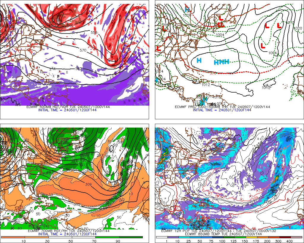
Here is the 12Z GFS precip_12 really showing nothing at the surface at all anywhere in the Atlantic through 384 hours when I loop the run. Maybe I am missing something Ivanhater or are you talking about the GFS supporting a mid/upper-level feature moving into Florida then the GOM?
http://mag.ncep.noaa.gov/list_files_are ... precip_p12
http://mag.ncep.noaa.gov/list_files_are ... precip_p12
0 likes
-
Ivanhater

- Storm2k Moderator

- Posts: 11221
- Age: 39
- Joined: Fri Jul 01, 2005 8:25 am
- Location: Pensacola
Re:
gatorcane wrote:Here is the 12Z GFS precip_12 really showing nothing at the surface at all anywhere in the Atlantic through 384 hours when I loop the run. Maybe I am missing something Ivanhater or are you talking about the GFS supporting a mid/upper-level feature moving into Florida then the GOM?
http://mag.ncep.noaa.gov/list_files_are ... precip_p12
yes, the 12z GFS 500mb chart is what I posted. The feature is present on the GFS that the CMC is showing so it is something to watch...
0 likes
Michael
-
cycloneye

- Admin

- Posts: 149472
- Age: 69
- Joined: Thu Oct 10, 2002 10:54 am
- Location: San Juan, Puerto Rico
Re: Global Model Runs Discussion
Two new Tweets by Levi Cowan about the possible trough split.
Levi Cowan @TropicalTidbits 8m
A tropical wave moving under an intense mid-upper low over 28C water is an unstable situation. GFS shows stacked vort pic.twitter.com/x3DUdyZbAM
Levi Cowan Levi Cowan @TropicalTidbits 11m
In 4-5 days trough-split mid-lvl piece moves N. of Antilles. Tropical wave from the east has chance to get involved. pic.twitter.com/t4P3BzeNXC


https://twitter.com/tropicaltidbits
Levi Cowan @TropicalTidbits 8m
A tropical wave moving under an intense mid-upper low over 28C water is an unstable situation. GFS shows stacked vort pic.twitter.com/x3DUdyZbAM
Levi Cowan Levi Cowan @TropicalTidbits 11m
In 4-5 days trough-split mid-lvl piece moves N. of Antilles. Tropical wave from the east has chance to get involved. pic.twitter.com/t4P3BzeNXC
https://twitter.com/tropicaltidbits
0 likes
Visit the Caribbean-Central America Weather Thread where you can find at first post web cams,radars
and observations from Caribbean basin members Click Here
and observations from Caribbean basin members Click Here
-
cycloneye
- Admin
- Posts: 149472
- Age: 69
- Joined: Thu Oct 10, 2002 10:54 am
- Location: San Juan, Puerto Rico
Re: Global Model Runs Discussion
Levi Cowan is very focused on this scenario. Here are yet two more tweets.
Levi Cowan @TropicalTidbits 5m
Wave can either catch up to ULL and take over and develop, or it could fail to catch up but be close enough to interfere w/ incipient vortex
Levi Cowan Levi Cowan @TropicalTidbits 6m
GFS shows tropical wave catching up to upper low. CMC says it won't. This will be key player. Wave can instigate development or hinder it
0 likes
Visit the Caribbean-Central America Weather Thread where you can find at first post web cams,radars
and observations from Caribbean basin members Click Here
and observations from Caribbean basin members Click Here
-
Ivanhater
- Storm2k Moderator
- Posts: 11221
- Age: 39
- Joined: Fri Jul 01, 2005 8:25 am
- Location: Pensacola
Re: Global Model Runs Discussion
12z Euro at 144 hours showing the wave moving SW toward Florida and the Gulf
0 likes
Michael
-
floridasun78
- Category 5

- Posts: 3755
- Joined: Sun May 17, 2009 10:16 pm
- Location: miami fl
Re: Global Model Runs Discussion
Ivanhater wrote:12z Euro at 144 hours showing the wave moving SW toward Florida and the Gulf
ok maybe euro joining cmc now we maybe catching some thing like Levi Cowan saw sunday on cmc
0 likes

Re: Global Model Runs Discussion
NOGAPS see something coming off the Yucatan and smashing the Upper Texas Coast...but when does the NOGAPS NOT see something.. 
https://www.fnmoc.navy.mil/wxmap_cgi/cg ... t=Tropical
https://www.fnmoc.navy.mil/wxmap_cgi/cg ... t=Tropical
0 likes
-
floridasun78
- Category 5
- Posts: 3755
- Joined: Sun May 17, 2009 10:16 pm
- Location: miami fl
Re: Global Model Runs Discussion
ROCK wrote:NOGAPS see something coming off the Yucatan and smashing the Upper Texas Coast...but when does the NOGAPS NOT see something..
https://www.fnmoc.navy.mil/wxmap_cgi/cg ... t=Tropical
NAVGEM show area coming toward fl too that be three Models
0 likes
-
floridasun78
- Category 5
- Posts: 3755
- Joined: Sun May 17, 2009 10:16 pm
- Location: miami fl
-
cycloneye
- Admin
- Posts: 149472
- Age: 69
- Joined: Thu Oct 10, 2002 10:54 am
- Location: San Juan, Puerto Rico
Re:
floridasun78 wrote:Euro ,cmc , NAVGEM
Also GFS but none develop.
0 likes
Visit the Caribbean-Central America Weather Thread where you can find at first post web cams,radars
and observations from Caribbean basin members Click Here
and observations from Caribbean basin members Click Here
-
Hurricaneman

- Category 5
- Posts: 7404
- Age: 45
- Joined: Tue Aug 31, 2004 3:24 pm
- Location: central florida
Re: Global Model Runs Discussion
trough splits in the area of bermuda have potential,Bob in 1991, Edouard in 2002 and Gaston in 2004 all formed in this fashion so this definately needs to be monitored in the coming days with all the model support its getting
0 likes
-
TheStormExpert
-
Hurricaneman
- Category 5
- Posts: 7404
- Age: 45
- Joined: Tue Aug 31, 2004 3:24 pm
- Location: central florida
Re: Global Model Runs Discussion
Out of all the storms I mentioned above I think the closest analog to what I think is going to happen with this trough split is Edouard in 2002 so we need to watch further runs to see what the evolution of this possible system is
0 likes

Re:
BigB0882 wrote:So now we have support from the GFS. Getting interesting...
I know CMC is often bullish on strength, what does 991 mb typically translate to?
To get the record straight, the CMC has no nupport from the GFS of tropical development out of the ULL forecasted to track westward.
0 likes
-
cycloneye
- Admin
- Posts: 149472
- Age: 69
- Joined: Thu Oct 10, 2002 10:54 am
- Location: San Juan, Puerto Rico
Re: Global Model Runs Discussion
There may be a caviat to any potential development if it happens at all as the pressure gradient north and south of ULL will not allow a LLC to form. Let's see how the models have this in next runs.

0 likes
Visit the Caribbean-Central America Weather Thread where you can find at first post web cams,radars
and observations from Caribbean basin members Click Here
and observations from Caribbean basin members Click Here
-
Hurricane Andrew

- S2K Supporter
- Posts: 1891
- Age: 27
- Joined: Sun May 23, 2010 2:53 pm
- Location: KS
Who is online
Users browsing this forum: No registered users and 41 guests