Atlantic hurricane season begins June 1
The Atlantic hurricane season starts in just over a week, and the long-range GFS model continues to suggest that the Western Caribbean will be capable of brewing the season's first "Invest" during the first week of June. The Madden Julian Oscillation (MJO), a pattern of increased thunderstorm activity near the Equator that moves around the globe in 30 - 60 days, is currently weak, but the latest GFS forecast predicts that the MJO will strengthen slightly in early June, and might be in a position to increase thunderstorm activity over the Western Caribbean then. While long range 10 - 16 day forecasts are notoriously unreliable, early June is a common time of year for the Western Caribbean to see a tropical disturbance form. Residents of Cuba, the Cayman Islands, Jamaica, Honduras, and Nicaragua should anticipate the possibility of a multi-day period of disturbed weather with heavy rainfall beginning around June 1.
Have a great Memorial Day weekend, everyone!
Jeff Masters
From Jeff Masers Blog
Global model runs discussion
Moderator: S2k Moderators
-
AtlanticWind

- S2K Supporter

- Posts: 1898
- Age: 67
- Joined: Sun Aug 08, 2004 9:57 pm
- Location: Plantation,Fla
-
cycloneye

- Admin

- Posts: 149508
- Age: 69
- Joined: Thu Oct 10, 2002 10:54 am
- Location: San Juan, Puerto Rico
Re: Global Model Runs Discussion
This is from an official source.
FOR THE LAST COUPLE OF DAYS, EVERY RUN OF THE GFS HAS INCLUDED THE
FORMATION OF A TROPICAL SYSTEM OFF THE COAST OF PANAMA, MOVING TO NEAR FLORIDA.
TODAY, THE CANADIAN MODEL HAS DONE THE SAME. BECAUSE THE ATLANTIC TROPICAL
SEASON OFFICIALLY STARTS ON JUNE 1, AND BECAUSE THE UPPER-LEVEL CONDITIONS ARE
FAVORABLE FOR TROPICAL DEVELOPMENT, PEOPLE WITH INTERESTS ALONG THE FLORIDA AND
GULF COASTS SHOULD KEEP UPDATED WITH THE MOST CURRENT INFORMATION COMING OUT OF
THE NATIONAL HURRICANE CENTER AND LOCAL FORECAST OFFICES.
http://forecast.weather.gov/product.php ... suedby=THR
0 likes
Visit the Caribbean-Central America Weather Thread where you can find at first post web cams,radars
and observations from Caribbean basin members Click Here
and observations from Caribbean basin members Click Here
-
Hurricane Alexis

- Category 2

- Posts: 683
- Age: 29
- Joined: Thu Jun 14, 2012 7:59 pm
- Location: Miami,Florida
Re: Global Model Runs Discussion
18z GFS shows nothing. Shows some lowering of pressures in the long range.
0 likes
Personal Forecast Disclaimer:
The posts in this forum are NOT official forecast and should not be used as such. They are just the opinion of the poster and may or may not be backed by sound meteorological data. They are NOT endorsed by any professional institution or storm2k.org. For official information, please refer to the NHC and NWS products.
The posts in this forum are NOT official forecast and should not be used as such. They are just the opinion of the poster and may or may not be backed by sound meteorological data. They are NOT endorsed by any professional institution or storm2k.org. For official information, please refer to the NHC and NWS products.
-
floridasun78
- Category 5

- Posts: 3755
- Joined: Sun May 17, 2009 10:16 pm
- Location: miami fl
Re: Global Model Runs Discussion
we see what happen .i reading setting maybe their for system by first week of june
0 likes

Re: Global Model Runs Discussion
cycloneye wrote:This is from an official source.
FOR THE LAST COUPLE OF DAYS, EVERY RUN OF THE GFS HAS INCLUDED THE
FORMATION OF A TROPICAL SYSTEM OFF THE COAST OF PANAMA, MOVING TO NEAR FLORIDA.
TODAY, THE CANADIAN MODEL HAS DONE THE SAME. BECAUSE THE ATLANTIC TROPICAL
SEASON OFFICIALLY STARTS ON JUNE 1, AND BECAUSE THE UPPER-LEVEL CONDITIONS ARE
FAVORABLE FOR TROPICAL DEVELOPMENT, PEOPLE WITH INTERESTS ALONG THE FLORIDA AND
GULF COASTS SHOULD KEEP UPDATED WITH THE MOST CURRENT INFORMATION COMING OUT OF
THE NATIONAL HURRICANE CENTER AND LOCAL FORECAST OFFICES.
http://forecast.weather.gov/product.php ... suedby=THR
0 likes
Andy D
(For official information, please refer to the NHC and NWS products.)
(For official information, please refer to the NHC and NWS products.)
-
Florida1118
Re: Global Model Runs Discussion
00z GFS picks it back up again. Starts festering around 240

Then moves North and consolidates a little

And the end result


Then moves North and consolidates a little

And the end result

0 likes
-
hurricanehunter69
- Category 1

- Posts: 344
- Joined: Sun May 16, 2010 5:21 pm
- Location: New Orleans
Re: Global Model Runs Discussion
A very long and lengthy persistence for this storm continues! The 00Z still on it. http://mag.ncep.noaa.gov/Image.php?fhr= ... =&ps=model
0 likes
-
cycloneye
- Admin
- Posts: 149508
- Age: 69
- Joined: Thu Oct 10, 2002 10:54 am
- Location: San Juan, Puerto Rico
Re: Global Model Runs Discussion
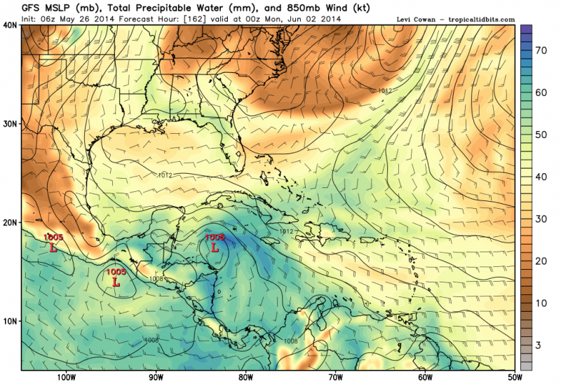
Broad low pressure at 240 hours of 12z GFS.

0 likes
Visit the Caribbean-Central America Weather Thread where you can find at first post web cams,radars
and observations from Caribbean basin members Click Here
and observations from Caribbean basin members Click Here
-
cycloneye
- Admin
- Posts: 149508
- Age: 69
- Joined: Thu Oct 10, 2002 10:54 am
- Location: San Juan, Puerto Rico
Re: Global Model Runs Discussion
12z GFS has dropped Caribbean area even if it still shows something there like a monsoonal gyre.
0 likes
Visit the Caribbean-Central America Weather Thread where you can find at first post web cams,radars
and observations from Caribbean basin members Click Here
and observations from Caribbean basin members Click Here
-
ninel conde
-
Yellow Evan

- Professional-Met

- Posts: 16240
- Age: 27
- Joined: Fri Jul 15, 2011 12:48 pm
- Location: Henderson, Nevada/Honolulu, HI
- Contact:
Re:
ninel conde wrote:i imagine amanda is going to flood the carib with shear. cant imagine anything other than a weak low being able to exist.
Why Amanda shear the Caribbean? Amanda is hundreds of miles away on the opposite side of the cost. And Amanda will be gone by then.
0 likes
-
ninel conde
-
Florida1118
Re: Global Model Runs Discussion
ninel conde wrote:major in the east pac=major shear and it will last well past amanda's demise.
Is that based on an actually science or...the Caribbean is full of shear to begin with, so Amanda seems pretty irrelevant, especially in the time frame the low was suppose to develop.
0 likes

Re: Global Model Runs Discussion
So, is nothing going to happen from this after it was predicted to develop earlier in the week?
0 likes


Re: Global Model Runs Discussion
sunnyday wrote:So, is nothing going to happen from this after it was predicted to develop earlier in the week?
I don't think anyone should have believed with certainty something was going to develop. The talk was about very long range (should always be with caution) and those should be taken with some skepticism. What it did show, and still does is areas of disturbed weather that MAY or may not organize in the Carib is all we should take from it.
0 likes
The above post and any post by Ntxw is NOT an official forecast and should not be used as such. It is just the opinion of the poster and may or may not be backed by sound meteorological data. It is NOT endorsed by any professional institution including Storm2k. For official information, please refer to NWS products.
Help support Storm2K!


Re: Global Model Runs Discussion
GFS pretty consistently has shown development over the last 20 or so runs. Latest 06z has a 1004 mb low in the western carribean that weakens as it moves N-NE into the Cedar Key area. Why does it weaken? The 200 mb winds are screaming at 50 kts in the eastern GOM. Of course this is 10 days out so much will change. But a weak-moderate highly sheared TS is pretty much the norm for early season development.
http://mag.ncep.noaa.gov/Image.php?fhr=228&image=data%2Fgfs%2F06%2Fgfs_wnatl_228_850_vort_ht.gif&model=gfs&area=wnatl¶m=850_vort_ht&group=Model+Guidance&preselected_formatted_cycle_date=20140526+06+UTC&imageSize=M&ps=model
http://mag.ncep.noaa.gov/Image.php?fhr=228&image=data%2Fgfs%2F06%2Fgfs_wnatl_228_850_vort_ht.gif&model=gfs&area=wnatl¶m=850_vort_ht&group=Model+Guidance&preselected_formatted_cycle_date=20140526+06+UTC&imageSize=M&ps=model
0 likes
-
CourierPR

- Category 5
- Posts: 1336
- Age: 72
- Joined: Tue Aug 31, 2004 7:53 pm
- Location: Pompano Beach, Florida
Re: Global Model Runs Discussion
The latest satellite image shows no precipitation in the Caribbean. Where will the moisture originate to feed any developing system?
0 likes
Who is online
Users browsing this forum: No registered users and 33 guests