EPAC: ANDRES - Post-Tropical
Moderator: S2k Moderators
-
xtyphooncyclonex

- Category 5

- Posts: 3688
- Age: 22
- Joined: Sat Dec 08, 2012 9:07 am
- Location: Cebu City
- Contact:
Back on topic, Andres is now the westernmost May major hurricane on record (It's 4:20PM June 1 in our place already  )
)

0 likes
REMINDER: My opinions that I, or any other NON Pro-Met in this forum, are unofficial. Please do not take my opinions as an official forecast and warning. I am NOT a meteorologist. Following my forecasts blindly may lead to false alarm, danger and risk if official forecasts from agencies are ignored.

Obviously this is an incredible situation, I was done with Andres thinking it missed the boat to CAT3 but instead of weakening, went to possible CAT5 (not sure but IMO I believe its 135 knots at least) status...how cray-cray. I was rolling my eyes at all the annular talk 2 days ago or so, well here it is too (not fully of course but showing signs) .
0 likes
-
xtyphooncyclonex
- Category 5
- Posts: 3688
- Age: 22
- Joined: Sat Dec 08, 2012 9:07 am
- Location: Cebu City
- Contact:
For ref, here's a cat 5 not too long ago

0 likes
REMINDER: My opinions that I, or any other NON Pro-Met in this forum, are unofficial. Please do not take my opinions as an official forecast and warning. I am NOT a meteorologist. Following my forecasts blindly may lead to false alarm, danger and risk if official forecasts from agencies are ignored.
-
Kingarabian

- S2K Supporter

- Posts: 15434
- Joined: Sat Aug 08, 2009 3:06 am
- Location: Honolulu, Hawaii
HURRICANE ANDRES DISCUSSION NUMBER 17
NWS NATIONAL HURRICANE CENTER MIAMI FL EP012015
200 AM PDT MON JUN 01 2015
The satellite appearance of Andres has changed little overnight.
The hurricane is exhibiting characteristics of an annular hurricane
with a well-defined 25 to 30 n mi wide eye, a symmetric mass of deep
convection, and a lack of outer banding features. A blend of the
subjective and objective Dvorak intensity estimates support an
initial intensity of 125 kt.
The hurricane is moving westward or 275 degrees at 5 kt. Andres
should turn west-northwestward, then northwestward during the next
couple of days while a mid-level ridge builds over northwestern
Mexico. By day 3, a deepening mid-latitude trough is expected to
approach the longitude of the tropical cyclone. Andres should be
much weaker by then, and will likely not respond as much to the
mid-level southwesterly flow. Therefore, the NHC forecast shows a
slow northward to northeastward motion at days 4 and 5. The
updated track is close to the Florida State Superensemble and is
near the middle of the model envelope.
Given the expected low shear conditions and annular characteristics
of Andres, the hurricane is likely to weaken a little less than
the guidance indicates today. After that, Andres will be moving
into a more stable environment and over cooler waters, which
should result in a faster rate of weakening. By day 3, increasing
southwesterly shear is likely to cause the circulation to decouple,
and Andres is forecast to become a post-tropical remnant low
shortly thereafter.
FORECAST POSITIONS AND MAX WINDS
INIT 01/0900Z 15.5N 119.8W 125 KT 145 MPH
12H 01/1800Z 16.1N 120.7W 120 KT 140 MPH
24H 02/0600Z 17.1N 122.2W 105 KT 120 MPH
36H 02/1800Z 18.1N 123.9W 85 KT 100 MPH
48H 03/0600Z 19.0N 125.2W 60 KT 70 MPH
72H 04/0600Z 20.2N 126.2W 40 KT 45 MPH
96H 05/0600Z 20.8N 125.5W 25 KT 30 MPH...POST-TROP/REMNT LOW
120H 06/0600Z 21.0N 125.0W 20 KT 25 MPH...POST-TROP/REMNT LOW
$$
Forecaster Brown
0 likes
RIP Kobe Bryant
-
Kingarabian
- S2K Supporter
- Posts: 15434
- Joined: Sat Aug 08, 2009 3:06 am
- Location: Honolulu, Hawaii
Re:
xtyphooncyclonex wrote:For ref, here's a cat 5 not too long ago
That's crazy.
Andres

Last edited by Kingarabian on Mon Jun 01, 2015 4:38 am, edited 1 time in total.
0 likes
RIP Kobe Bryant
-
Yellow Evan

- Professional-Met

- Posts: 15952
- Age: 25
- Joined: Fri Jul 15, 2011 12:48 pm
- Location: Henderson, Nevada/Honolulu, HI
- Contact:
-
Yellow Evan
- Professional-Met
- Posts: 15952
- Age: 25
- Joined: Fri Jul 15, 2011 12:48 pm
- Location: Henderson, Nevada/Honolulu, HI
- Contact:
-
Yellow Evan
- Professional-Met
- Posts: 15952
- Age: 25
- Joined: Fri Jul 15, 2011 12:48 pm
- Location: Henderson, Nevada/Honolulu, HI
- Contact:

Re: EPAC: ANDRES - Hurricane
Looks like a category 5 STY just like the 3 we had here...
0 likes
Remember, all of my post aren't official. For official warnings and discussions, Please refer to your local NWS products...
NWS for the Western Pacific
https://www.weather.gov/gum/
NWS for the Western Pacific
https://www.weather.gov/gum/
-
Yellow Evan
- Professional-Met
- Posts: 15952
- Age: 25
- Joined: Fri Jul 15, 2011 12:48 pm
- Location: Henderson, Nevada/Honolulu, HI
- Contact:
-
Yellow Evan
- Professional-Met
- Posts: 15952
- Age: 25
- Joined: Fri Jul 15, 2011 12:48 pm
- Location: Henderson, Nevada/Honolulu, HI
- Contact:
TXPZ26 KNES 011219
TCSENP
A. 01E (ANDRES)
B. 01/1200Z
C. 15.6N
D. 120.0W
E. ONE/GOES-W
F. T6.0/6.0/D1.0/24HRS
G. IR/EIR/SWIR
H. REMARKS...CENTRAL FEATURE HAS EMBEDDED TEMPERATURE OF BLACK GIVING
AN EYE NUMBER OF 5.5 WITH AN OFF WHITE EYE AND A WHITE RING YIELDING
AN EYE ADJUSTMENT OF +.5 FOR A FINAL FT OF 6.0. MET IS 6.0 BASED ON
DEVELOPMENT COMPARED TO 24 HOURS AGO. PT IS 6.0. FT IS BASED ON DT.
I. ADDL POSITIONS
NIL
Edit: Now it makes semi-sense
Last edited by Yellow Evan on Mon Jun 01, 2015 8:00 am, edited 1 time in total.
0 likes
-
xtyphooncyclonex
- Category 5
- Posts: 3688
- Age: 22
- Joined: Sat Dec 08, 2012 9:07 am
- Location: Cebu City
- Contact:
Looks better than Noul and Dolphin at peak IMO

0 likes
REMINDER: My opinions that I, or any other NON Pro-Met in this forum, are unofficial. Please do not take my opinions as an official forecast and warning. I am NOT a meteorologist. Following my forecasts blindly may lead to false alarm, danger and risk if official forecasts from agencies are ignored.
-
Yellow Evan
- Professional-Met
- Posts: 15952
- Age: 25
- Joined: Fri Jul 15, 2011 12:48 pm
- Location: Henderson, Nevada/Honolulu, HI
- Contact:
No doubt if the NHC brought Recon in, this would be a Cat 5.
Last edited by Yellow Evan on Mon Jun 01, 2015 7:40 am, edited 1 time in total.
0 likes
-
Yellow Evan
- Professional-Met
- Posts: 15952
- Age: 25
- Joined: Fri Jul 15, 2011 12:48 pm
- Location: Henderson, Nevada/Honolulu, HI
- Contact:
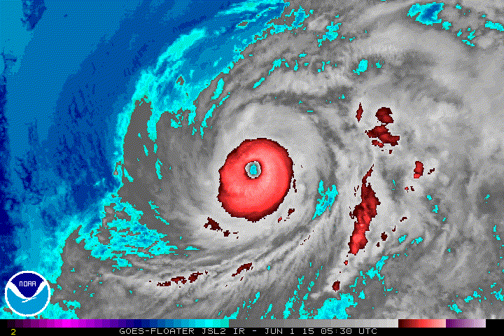
Eye cooling.
----- Current Analysis -----
Date : 01 JUN 2015 Time : 113000 UTC
Lat : 15:28:53 N Lon : 119:59:26 W
CI# /Pressure/ Vmax
6.7 / 933.2mb/132.2kt
Final T# Adj T# Raw T#
6.7 6.8 6.8
Estimated radius of max. wind based on IR : 23 km
Center Temp : +7.7C Cloud Region Temp : -72.5C
Scene Type : EYE
----- Current Analysis -----
Date : 01 JUN 2015 Time : 113000 UTC
Lat : 15:28:53 N Lon : 119:59:26 W
CI# /Pressure/ Vmax
6.7 / 933.2mb/132.2kt
Final T# Adj T# Raw T#
6.7 6.8 6.8
Estimated radius of max. wind based on IR : 23 km
Center Temp : +7.7C Cloud Region Temp : -72.5C
Scene Type : EYE
0 likes
-
cycloneye

- Admin

- Posts: 139081
- Age: 67
- Joined: Thu Oct 10, 2002 10:54 am
- Location: San Juan, Puerto Rico
Re: EPAC: ANDRES - Hurricane
Remains at 125kts.
EP, 01, 2015060112, , BEST, 0, 156N, 1200W, 125, 938, HU
EP, 01, 2015060112, , BEST, 0, 156N, 1200W, 125, 938, HU
0 likes
Visit the Caribbean-Central America Weather Thread where you can find at first post web cams,radars
and observations from Caribbean basin members Click Here
and observations from Caribbean basin members Click Here
-
Yellow Evan
- Professional-Met
- Posts: 15952
- Age: 25
- Joined: Fri Jul 15, 2011 12:48 pm
- Location: Henderson, Nevada/Honolulu, HI
- Contact:
-
Yellow Evan
- Professional-Met
- Posts: 15952
- Age: 25
- Joined: Fri Jul 15, 2011 12:48 pm
- Location: Henderson, Nevada/Honolulu, HI
- Contact:
* EAST PACIFIC SHIPS INTENSITY FORECAST *
* IR SAT DATA AVAILABLE, OHC AVAILABLE *
* ANDRES EP012015 06/01/15 12 UTC *
TIME (HR) 0 6 12 18 24 36 48 60 72 84 96 108 120
V (KT) NO LAND 125 118 108 95 85 63 45 29 DIS DIS DIS DIS DIS
V (KT) LAND 125 118 108 95 85 63 45 29 DIS DIS DIS DIS DIS
V (KT) LGE mod 125 118 108 97 86 68 54 44 36 29 24 19 16
Storm Type TROP TROP TROP TROP TROP TROP TROP TROP TROP TROP TROP TROP TROP
SHEAR (KT) 8 9 10 11 9 6 10 16 27 25 19 11 16
SHEAR ADJ (KT) -1 0 2 3 5 5 1 3 6 1 6 6 4
SHEAR DIR 291 274 241 238 236 213 221 229 249 245 231 196 199
SST (C) 27.1 27.0 26.7 26.3 25.9 25.5 24.7 24.0 23.7 23.5 23.5 23.4 23.4
POT. INT. (KT) 133 133 130 126 122 117 108 99 96 94 93 91 90
200 MB T (C) -51.7 -51.5 -51.2 -51.4 -51.6 -51.3 -52.0 -51.7 -51.8 -51.6 -51.4 -50.8 -50.7
TH_E DEV (C) 6 5 5 4 3 2 2 2 2 2 2 2 2
700-500 MB RH 65 63 63 61 61 58 54 49 44 33 24 14 8
MODEL VTX (KT) 34 34 34 32 33 30 27 25 23 21 18 13 7
850 MB ENV VOR 56 66 77 75 67 71 58 64 72 79 87 80 72
200 MB DIV 17 19 16 -7 5 1 0 14 -1 -23 -20 -30 -33
700-850 TADV 0 1 6 14 16 8 10 4 3 -3 -2 -5 0
LAND (KM) 1299 1304 1313 1340 1373 1417 1426 1429 1393 1347 1285 1261 1261
LAT (DEG N) 15.6 16.1 16.5 17.0 17.5 18.5 19.3 19.9 20.3 20.6 20.8 20.9 20.9
LONG(DEG W) 120.0 120.7 121.3 122.2 123.0 124.5 125.5 126.1 126.0 125.7 125.1 124.9 124.9
STM SPEED (KT) 6 8 8 10 9 7 5 3 2 3 2 0 0
HEAT CONTENT 5 9 0 0 0 0 0 0 0 0 0 0 0
0 likes
-
Yellow Evan
- Professional-Met
- Posts: 15952
- Age: 25
- Joined: Fri Jul 15, 2011 12:48 pm
- Location: Henderson, Nevada/Honolulu, HI
- Contact:
UW - CIMSS
ADVANCED DVORAK TECHNIQUE
ADT-Version 8.2.1
Tropical Cyclone Intensity Algorithm
----- Current Analysis -----
Date : 01 JUN 2015 Time : 120000 UTC
Lat : 15:30:43 N Lon : 120:02:21 W
CI# /Pressure/ Vmax
6.7 / 932.8mb/132.2kt
Final T# Adj T# Raw T#
6.7 6.9 6.9
Estimated radius of max. wind based on IR : 23 km
Center Temp : +7.0C Cloud Region Temp : -72.9C
Scene Type : EYE
Ooh, very close to 7.0.
0 likes
-
tolakram
- Admin
- Posts: 19165
- Age: 60
- Joined: Sun Aug 27, 2006 8:23 pm
- Location: Florence, KY (name is Mark)
Re: EPAC: ANDRES - Hurricane
Looks like a new burst, but IMO it doesn't quite have the look of a cat 5. What do I know though. 
0 likes
M a r k
- - - - -
Join us in chat: Storm2K Chatroom Invite. Android and IOS apps also available.
The posts in this forum are NOT official forecasts and should not be used as such. Posts are NOT endorsed by any professional institution or STORM2K.org. For official information and forecasts, please refer to NHC and NWS products.
-
cycloneye
- Admin
- Posts: 139081
- Age: 67
- Joined: Thu Oct 10, 2002 10:54 am
- Location: San Juan, Puerto Rico
Re: EPAC: ANDRES - Hurricane
Updated down to 120kts.
EP, 01, 2015060112, , BEST, 0, 156N, 1200W, 120, 943, HU
EP, 01, 2015060112, , BEST, 0, 156N, 1200W, 120, 943, HU
0 likes
Visit the Caribbean-Central America Weather Thread where you can find at first post web cams,radars
and observations from Caribbean basin members Click Here
and observations from Caribbean basin members Click Here
Who is online
Users browsing this forum: No registered users and 133 guests