ATL: BILL - Models
Moderator: S2k Moderators

Re: ATL: INVEST 91L - Models
We might not know anything for the next couple days, but people have to keep an eye on this due to the amount of rain everybody here has gotten and need to prepare for more flooding.
0 likes
Personal Forecast Disclaimer:
The posts in this forum are NOT official forecast and should not be used as such. They are just the opinion of the poster and may or may not be backed by sound meteorological data. They are NOT endorsed by any professional institution or storm2k.org. For official information, please refer to the NHC and NWS products.
The posts in this forum are NOT official forecast and should not be used as such. They are just the opinion of the poster and may or may not be backed by sound meteorological data. They are NOT endorsed by any professional institution or storm2k.org. For official information, please refer to the NHC and NWS products.
Re: ATL: INVEST 91L - Models
CYCLONE MIKE wrote:Until this invest emerges in the gulf and we see how much or little it develops models are just throwing darts right now. We have to watch for center relocations, what the ridge does out in the atl, and like I said how much it strengthens. Might not have a good idea til this time tomorrow.
this is posted every time and every time it has to be stated that that idea is scientifically untrue. Dynamical mdoels are quite capable of producing their own center.
We seem to be stuck in the 1990s where the only models worth anything were the track models that needed a center inputted into them.
0 likes
-
CYCLONE MIKE
- Category 5

- Posts: 2183
- Joined: Tue Aug 31, 2004 6:04 pm
- Location: Gonzales, LA
Re: ATL: INVEST 91L - Models
If that's the case they should be dead on and there should never be any swings in track more than 50 miles days out from landfall then.
0 likes
-
stormlover2013
- Category 5
- Posts: 2312
- Joined: Thu Aug 22, 2013 12:06 pm
- Location: Lumberton, Texas
Re: ATL: INVEST 91L - Models
Which I tend to agree, but models do struggle until the llc develops I mean especially when it's overland like it is now
0 likes
Re: ATL: INVEST 91L - Models
CYCLONE MIKE wrote:If that's the case they should be dead on and there should never be any swings in track more than 50 miles days out from landfall then.
it's clear you have zero understanding of numerical modeling. I'll leave it at that and not get into an argument
0 likes
-
CYCLONE MIKE
- Category 5
- Posts: 2183
- Joined: Tue Aug 31, 2004 6:04 pm
- Location: Gonzales, LA
Re: ATL: INVEST 91L - Models
Might be just slightly more than zero. But will just sit back and see what happens come tomorrow evening should a center actually develop.
0 likes
-
Rgv20

- S2K Supporter

- Posts: 2456
- Age: 37
- Joined: Wed Jan 05, 2011 5:42 pm
- Location: Edinburg/McAllen Tx
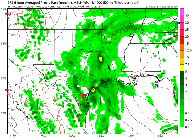
0zGFS trended a bit south with 91L...Lots of Rain for all of the Texas coast and it looks like the GFS wants to slow it down after landfall..
0zGFS forecast valid for Monday Evening
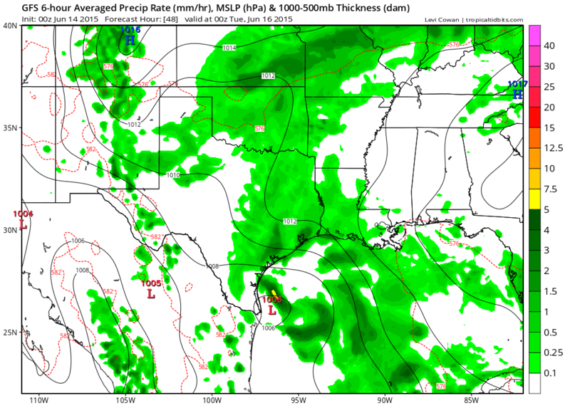
0zGFS forecast valid for Tuesday Evening
0zGFS forecast valid for Monday Evening

0zGFS forecast valid for Tuesday Evening

0 likes
The following post is NOT an official forecast and should not be used as such. It is just the opinion of the poster and may or may not be backed by sound meteorological data. It is NOT endorsed by any professional institution including storm2k.org For Official Information please refer to the NHC and NWS products.
-
Hurricaneman

- Category 5
- Posts: 7281
- Age: 43
- Joined: Tue Aug 31, 2004 3:24 pm
- Location: central florida
-
Rgv20
- S2K Supporter
- Posts: 2456
- Age: 37
- Joined: Wed Jan 05, 2011 5:42 pm
- Location: Edinburg/McAllen Tx
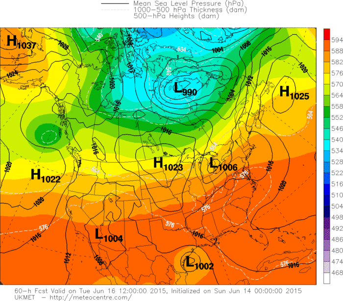
0zUKMET has 91L close to Corpus by Tuesday Morning and than moves it NW after that..

0 likes
The following post is NOT an official forecast and should not be used as such. It is just the opinion of the poster and may or may not be backed by sound meteorological data. It is NOT endorsed by any professional institution including storm2k.org For Official Information please refer to the NHC and NWS products.

NAM looks like it's developing the northern portion of the low, and it did fairly well with Ana last month.
0 likes
The above post is not official and should not be used as such. It is the opinion of the poster and may or may not be backed by sound meteorological data. It is not endorsed by any professional institution or storm2k.org. For official information, please refer to the NHC and NWS products.
-
stormlover2013
- Category 5
- Posts: 2312
- Joined: Thu Aug 22, 2013 12:06 pm
- Location: Lumberton, Texas
Re: ATL: INVEST 91L - Models
If that happens then models will shift closer to upper Texas coast, Galveston
0 likes
Re:
Alyono wrote:12Z MU continues with the idea that this will remain as a trough and not a TC
I've noticed it seems to develop anything and everything, unless there is actually a shot at development.
0 likes
The above post is not official and should not be used as such. It is the opinion of the poster and may or may not be backed by sound meteorological data. It is not endorsed by any professional institution or storm2k.org. For official information, please refer to the NHC and NWS products.
-
SouthDadeFish

- Professional-Met

- Posts: 2835
- Joined: Thu Sep 23, 2010 2:54 pm
- Location: Miami, FL
- Contact:

Yep and the last thing we need in SE TX.
0 likes
The following post is NOT an official forecast and should not be used as such. It is just the opinion of the poster and may or may not be backed by sound meteorological data. It is NOT endorsed by any professional institution including storm2k.org For Official Information please refer to the NHC and NWS products.
-
Portastorm

- Storm2k Moderator

- Posts: 9787
- Age: 61
- Joined: Fri Jul 11, 2003 9:16 am
- Location: South Austin, TX
- Contact:
Re: ATL: INVEST 91L - Models
0z tropical model runs ... seeing spread now in potential "landfall" areas:

0 likes
Any forecasts under my name are to be taken with a grain of salt. Get your best forecasts from the National Weather Service and National Hurricane Center.
I'm a certified Advanced SKYWARN-trained spotter and am active on Twitter at @TravisCOSW, a social media partner of the NWS Austin-San Antonio office.
I'm a certified Advanced SKYWARN-trained spotter and am active on Twitter at @TravisCOSW, a social media partner of the NWS Austin-San Antonio office.
-
floridasun78
- Category 5
- Posts: 3755
- Joined: Sun May 17, 2009 10:16 pm
- Location: miami fl
Re: ATL: INVEST 91L - Models
Portastorm wrote:0z tropical model runs ... seeing spread now in potential "landfall" areas:
all of tx in it
0 likes
-
Rgv20
- S2K Supporter
- Posts: 2456
- Age: 37
- Joined: Wed Jan 05, 2011 5:42 pm
- Location: Edinburg/McAllen Tx
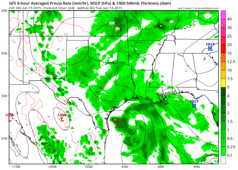
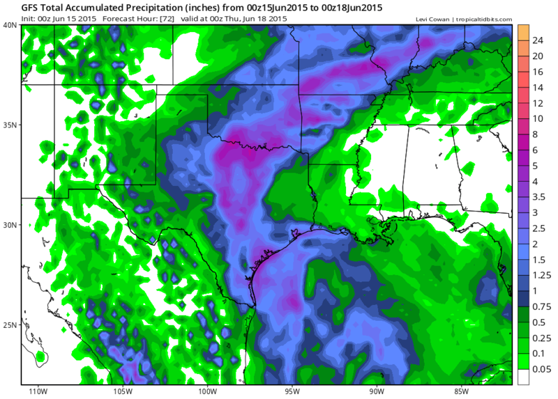
The GFS for the past several runs has 91L making landfall in South Texas between Corpus and Brownsville...UKMET, ECMWF, CMC, GFDL, HWRF are all more north. 0zGFS sticks to its guns..
Monday Evening
Tuesday Morning
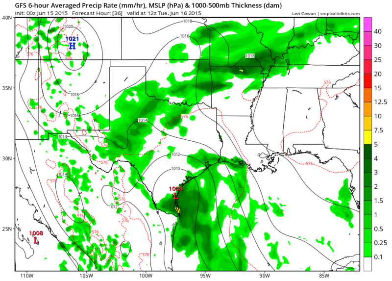
Total Rainfall thru Wednesday Evening....even if it takes the Southern Route much of Texas will get some big rain out of it!
Monday Evening

Tuesday Morning

Total Rainfall thru Wednesday Evening....even if it takes the Southern Route much of Texas will get some big rain out of it!

0 likes
The following post is NOT an official forecast and should not be used as such. It is just the opinion of the poster and may or may not be backed by sound meteorological data. It is NOT endorsed by any professional institution including storm2k.org For Official Information please refer to the NHC and NWS products.
-
stormlover2013
- Category 5
- Posts: 2312
- Joined: Thu Aug 22, 2013 12:06 pm
- Location: Lumberton, Texas
-
Rgv20
- S2K Supporter
- Posts: 2456
- Age: 37
- Joined: Wed Jan 05, 2011 5:42 pm
- Location: Edinburg/McAllen Tx

0 likes
The following post is NOT an official forecast and should not be used as such. It is just the opinion of the poster and may or may not be backed by sound meteorological data. It is NOT endorsed by any professional institution including storm2k.org For Official Information please refer to the NHC and NWS products.
Who is online
Users browsing this forum: No registered users and 122 guests