ATL: 90L - ERIKA Remnants - Models
Moderator: S2k Moderators
-
tolakram
- Admin

- Posts: 19165
- Age: 60
- Joined: Sun Aug 27, 2006 8:23 pm
- Location: Florence, KY (name is Mark)
Re: ATL: ERIKA - Models
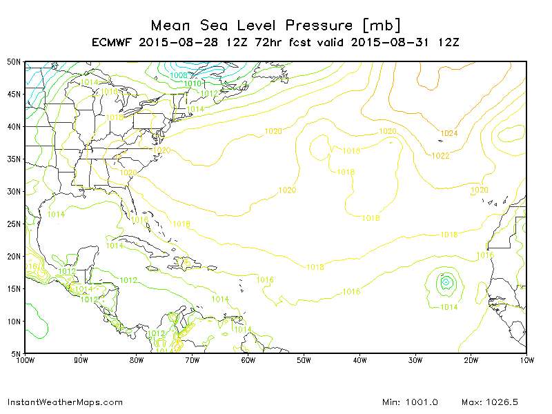
Gone at 72.
0 likes
M a r k
- - - - -
Join us in chat: Storm2K Chatroom Invite. Android and IOS apps also available.
The posts in this forum are NOT official forecasts and should not be used as such. Posts are NOT endorsed by any professional institution or STORM2K.org. For official information and forecasts, please refer to NHC and NWS products.
-
tolakram
- Admin
- Posts: 19165
- Age: 60
- Joined: Sun Aug 27, 2006 8:23 pm
- Location: Florence, KY (name is Mark)
Re: ATL: ERIKA - Models
0 likes
M a r k
- - - - -
Join us in chat: Storm2K Chatroom Invite. Android and IOS apps also available.
The posts in this forum are NOT official forecasts and should not be used as such. Posts are NOT endorsed by any professional institution or STORM2K.org. For official information and forecasts, please refer to NHC and NWS products.
- - - - -
Join us in chat: Storm2K Chatroom Invite. Android and IOS apps also available.
The posts in this forum are NOT official forecasts and should not be used as such. Posts are NOT endorsed by any professional institution or STORM2K.org. For official information and forecasts, please refer to NHC and NWS products.

-
otowntiger
- Category 5

- Posts: 1787
- Joined: Tue Aug 31, 2004 7:06 pm
- Location: Orlando
Re: ATL: ERIKA - Models
The escape route for what? There is no tropical system left on that map, lol. I'm surprised that there are so few models even depicting the slightest low pressure center after 72 hours. Seems like there is a lot of energy with this system for it to just go poof.
disclaimer: I'm not a pro meteorologist so don't listen to me.
disclaimer: I'm not a pro meteorologist so don't listen to me.
0 likes
-
tolakram
- Admin
- Posts: 19165
- Age: 60
- Joined: Sun Aug 27, 2006 8:23 pm
- Location: Florence, KY (name is Mark)
Re: ATL: ERIKA - Models
114 hour Weatherbell graphics show weak low 30kt wind speeds in the big bend area. 
0 likes
M a r k
- - - - -
Join us in chat: Storm2K Chatroom Invite. Android and IOS apps also available.
The posts in this forum are NOT official forecasts and should not be used as such. Posts are NOT endorsed by any professional institution or STORM2K.org. For official information and forecasts, please refer to NHC and NWS products.
- - - - -
Join us in chat: Storm2K Chatroom Invite. Android and IOS apps also available.
The posts in this forum are NOT official forecasts and should not be used as such. Posts are NOT endorsed by any professional institution or STORM2K.org. For official information and forecasts, please refer to NHC and NWS products.
-
tolakram
- Admin
- Posts: 19165
- Age: 60
- Joined: Sun Aug 27, 2006 8:23 pm
- Location: Florence, KY (name is Mark)
Re: ATL: ERIKA - Models
As much trouble as the models have had, the accuracy here has got to be horrible.
0 likes
M a r k
- - - - -
Join us in chat: Storm2K Chatroom Invite. Android and IOS apps also available.
The posts in this forum are NOT official forecasts and should not be used as such. Posts are NOT endorsed by any professional institution or STORM2K.org. For official information and forecasts, please refer to NHC and NWS products.
- - - - -
Join us in chat: Storm2K Chatroom Invite. Android and IOS apps also available.
The posts in this forum are NOT official forecasts and should not be used as such. Posts are NOT endorsed by any professional institution or STORM2K.org. For official information and forecasts, please refer to NHC and NWS products.

-
TheProfessor

- Professional-Met

- Posts: 3505
- Age: 27
- Joined: Tue Dec 03, 2013 10:56 am
- Location: Wichita, Kansas
Re: ATL: ERIKA - Models
otowntiger wrote:The escape route for what? There is no tropical system left on that map, lol. I'm surprised that there are so few models even depicting the slightest low pressure center after 72 hours. Seems like there is a lot of energy with this system for it to just go poof.
disclaimer: I'm not a pro meteorologist so don't listen to me.
There have been some pretty decent size storms that have just gone poof before, like Don in 2011 when he got eaten by the Texas Death Ridge.
0 likes
An alumnus of The Ohio State University.
Your local National Weather Service office is your best source for weather information.
Your local National Weather Service office is your best source for weather information.
-
OuterBanker
- S2K Supporter

- Posts: 1704
- Joined: Wed Feb 26, 2003 10:53 am
- Location: Nags Head, NC
- Contact:
Re: ATL: ERIKA - Models
tolakram wrote:Gone at 72.
Is that Fred around 25W (Cape Verde) I see. Oh goodee another one we can dream and waste our time on.
We should have made a poll on how many long trackers would make it to the US mainland.
0 likes

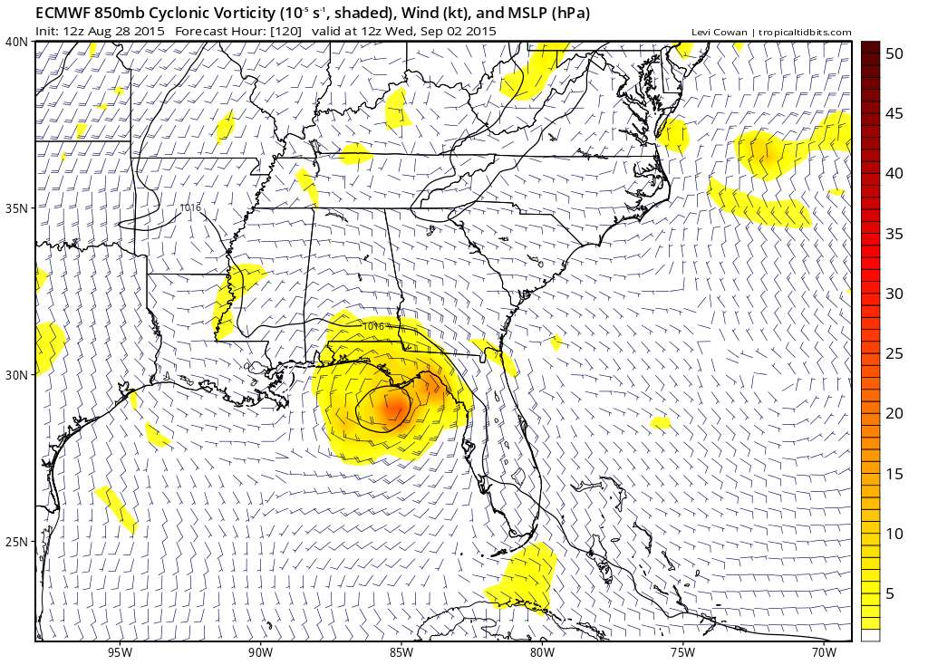
Re: ATL: ERIKA - Models
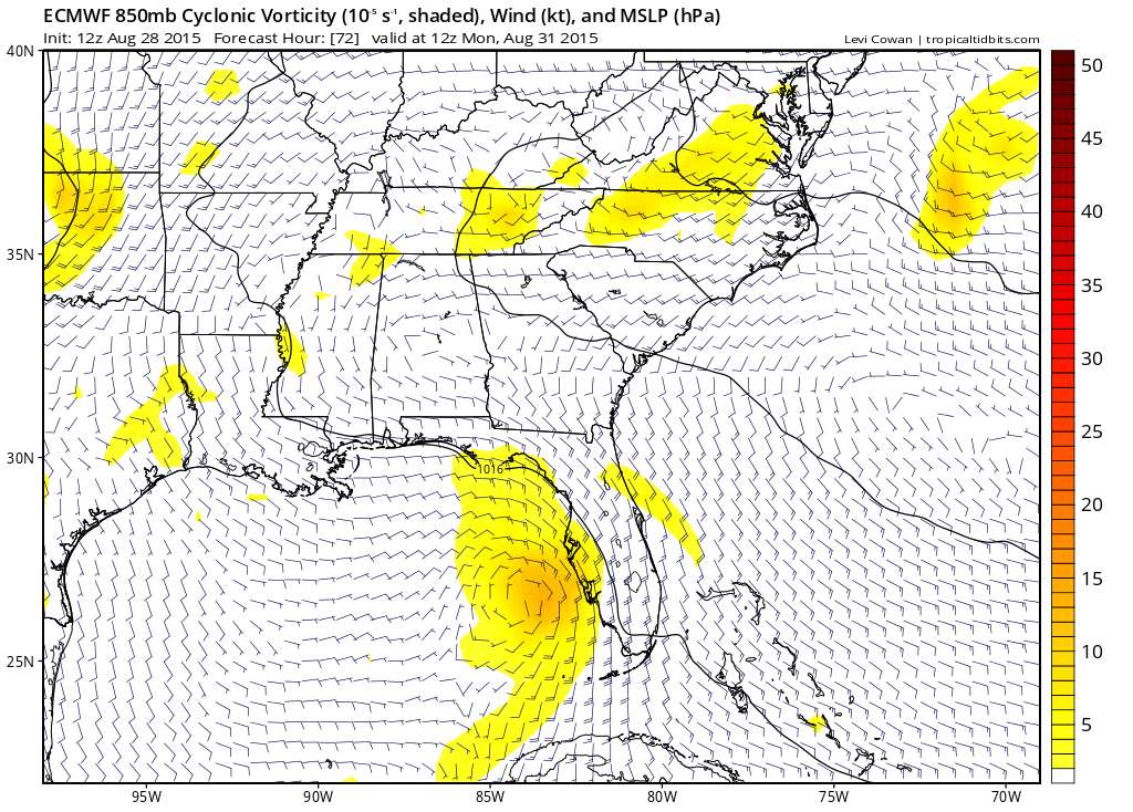
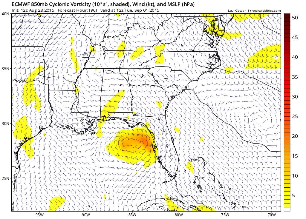
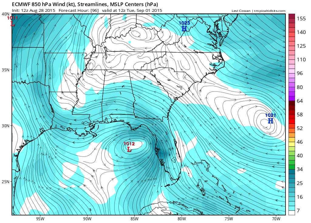
Vorticity pretty strong on the Euro over the GOM - wouldn't write it off yet. Track looks pretty consistent now too.
0 likes
-
tolakram
- Admin
- Posts: 19165
- Age: 60
- Joined: Sun Aug 27, 2006 8:23 pm
- Location: Florence, KY (name is Mark)
Re: ATL: ERIKA - Models
Very rare for a Cape Verde system to make it to the east coast. I'm looking for another major to spin harmlessly over water, staying away from all the islands.
0 likes
M a r k
- - - - -
Join us in chat: Storm2K Chatroom Invite. Android and IOS apps also available.
The posts in this forum are NOT official forecasts and should not be used as such. Posts are NOT endorsed by any professional institution or STORM2K.org. For official information and forecasts, please refer to NHC and NWS products.
- - - - -
Join us in chat: Storm2K Chatroom Invite. Android and IOS apps also available.
The posts in this forum are NOT official forecasts and should not be used as such. Posts are NOT endorsed by any professional institution or STORM2K.org. For official information and forecasts, please refer to NHC and NWS products.
Re: ATL: ERIKA - Models
OuterBanker wrote:tolakram wrote:Gone at 72.
Is that Fred around 25W (Cape Verde) I see. Oh goodee another one we can dream and waste our time on.
We should have made a poll on how many long trackers would make it to the US mainland.
If you had polled me before the season started, I would have said zero based on the 17 prior oncoming strong Nino's. If you mean anything documented that attained TS status east of 50W in the MDR and later hits the CONUS, I could find only two storms since the late 1800's during the 17 oncoming strong El Nino's:
In 1930, this became a TS at 49.8W: http://weather.unisys.com/hurricane/atl ... /track.gif
In 1899, this became a TS at 31W: http://weather.unisys.com/hurricane/atl ... /track.gif
Edit: It is going to be hard for this year's Fred to get to the interest level of the prior Fred in 2009. That one was fascinating to follow. I remember even Ninel getting excited about it!
0 likes
Personal Forecast Disclaimer:
The posts in this forum are NOT official forecasts and should not be used as such. They are just the opinion of the poster and may or may not be backed by sound meteorological data. They are NOT endorsed by any professional institution or storm2k.org. For official information, please refer to the NHC and NWS products.
The posts in this forum are NOT official forecasts and should not be used as such. They are just the opinion of the poster and may or may not be backed by sound meteorological data. They are NOT endorsed by any professional institution or storm2k.org. For official information, please refer to the NHC and NWS products.
-
petit_bois

- Tropical Storm

- Posts: 227
- Joined: Tue Jun 22, 2010 12:04 pm
- Location: Petit Bois Island Mississippi
Any possibility of a closed low in the GOM in early September is not a good thing. Bear watching.
0 likes
Resident of the Atlantic Basin's Major Hurricane Hit Capital!
Camille (200+winds), Frederic, Goerges, Katrina... and many many more.
Disclaimer: I'm likely the smartest guy here... but I have no idea where a tropical cyclone will go. I suggest you take my opinion as a grain of salt. I suggest you look to the National Hurricane Center for accurate info.
Camille (200+winds), Frederic, Goerges, Katrina... and many many more.
Disclaimer: I'm likely the smartest guy here... but I have no idea where a tropical cyclone will go. I suggest you take my opinion as a grain of salt. I suggest you look to the National Hurricane Center for accurate info.
-
OuterBanker
- S2K Supporter
- Posts: 1704
- Joined: Wed Feb 26, 2003 10:53 am
- Location: Nags Head, NC
- Contact:
-
StarmanHDB

- Tropical Storm
- Posts: 201
- Age: 59
- Joined: Wed Sep 02, 2009 7:59 pm
- Location: West Palm Beach, Florida
Re:
OuterBanker wrote:It just goes to prove just how unique and once in a lifetime 2005 was. Just about everything developed.
I don't think we will ever see that again.
And even though all of those storms and the activity associated with them was exciting, the destruction, deaths, and ruined lives brought about by the 2005 North Atlantic hurricane season should never be repeated again, but as we all know, nature doesn't care what we want. All we can do is learn from the past, hope for the best all the while preparing for the worst. Even though we've had it relatively easy since then, 2005 should always serve as a reminder to always be ready.
0 likes
-
Weatherlover12
- Tropical Depression

- Posts: 68
- Joined: Wed Aug 19, 2015 11:41 am
-
CYCLONE MIKE
- Category 5
- Posts: 2183
- Joined: Tue Aug 31, 2004 6:04 pm
- Location: Gonzales, LA
Re:
OuterBanker wrote:It just goes to prove just how unique and once in a lifetime 2005 was. Just about everything developed.
I don't think we will ever see that again.
Couldn't agree more, well said. It wasn't called record breaking and historic for nothing, only to be repeated a few years later.
0 likes
Who is online
Users browsing this forum: No registered users and 60 guests