EPAC: PATRICIA - Post-Tropical

Moderator: S2k Moderators

Message
Author
User avatar
Yellow Evan
Professional-Met
Professional-Met
Posts: 15948
Age: 25
Joined: Fri Jul 15, 2011 12:48 pm
Location: Henderson, Nevada/Honolulu, HI
Contact:

Re: Re:

#1341 Postby Yellow Evan » Sat Oct 24, 2015 11:00 am

xtyphooncyclonex wrote:
ConAntares wrote:Patricia is alarming!
But I still think Typhoon Haiyan is the strongest storm in Pacific Ocean! Which has a horror CDG eye wall and a huge CDO!

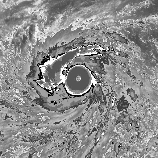
Patricia was smaller, yet it's eye was much warmer and it's CDG was also present. Haiyan is stronger than Patricia at landfall, but other than that, I honestly prefer Patricia.

Image

Image

Image


Haiyan and Patricia are two diffent storm types. Haiyan is CDO dominant while Patricia had two bands. Patricia's eye was likely underestimated due to viewing angle issues on SAB (with things working properly, likely was around 15C-20C). Still, Haiyan was better organized and likely had the warmer eye and thicker CDO.
0 likes   

User avatar
Yellow Evan
Professional-Met
Professional-Met
Posts: 15948
Age: 25
Joined: Fri Jul 15, 2011 12:48 pm
Location: Henderson, Nevada/Honolulu, HI
Contact:

Re: EPAC: PATRICIA - Hurricane: History is made

#1342 Postby Yellow Evan » Sat Oct 24, 2015 11:04 am

Alyono wrote:from the recon we did have in 2010, WPAC storms typically don't have pressures much lower. We can surmise that the traditional P/W relationships were inaccurate. What we had was a storm forming from a monsoon trough. These hurricanes/typhoons will have lower pressures than others. It's not the basin. It's the type of genesis and its surrounding environment that determines the P/W relationship


CrazyC83 wrote:
Monsoonal trough storms in the WPAC likely have low pressures as well. However that didn't apply in the case of Megi in 2010, and likely didn't apply in the case of Haiyan in 2013 based on the limited data available either (from surface observations).

The outermost closed isobar in Patricia was 1004mb, which is very low.


Couldn't agree more. Some storms like Alex 10 seem to follow the so called WPAC P/W relationship, while others like Yais and Megi follow the ATL P/W relationship.
0 likes   

supercane4867
Category 5
Category 5
Posts: 4966
Joined: Wed Nov 14, 2012 10:43 am

Re: EPAC: PATRICIA - Tropical Depression

#1343 Postby supercane4867 » Sat Oct 24, 2015 11:08 am

In these cases you cannot just compare cloudtop temps to judge intensity as they were located in different latitudes and tropospheric environment. There aren't much similarities between Patricia and Haiyan other than both being unusually strong.
0 likes   

supercane4867
Category 5
Category 5
Posts: 4966
Joined: Wed Nov 14, 2012 10:43 am

Re: Re:

#1344 Postby supercane4867 » Sat Oct 24, 2015 11:14 am

Yellow Evan wrote:
xtyphooncyclonex wrote:
ConAntares wrote:Patricia is alarming!
But I still think Typhoon Haiyan is the strongest storm in Pacific Ocean! Which has a horror CDG eye wall and a huge CDO!

Haiyan and Patricia are two diffent storm types. Haiyan is CDO dominant while Patricia had two bands. Patricia's eye was likely underestimated due to viewing angle issues on SAB (with things working properly, likely was around 15C-20C). Still, Haiyan was better organized and likely had the warmer eye and thicker CDO.

I just don't get why subjective analysis are so stubborn on using geostationary satellite while VIIRS and MODIS data clearly show the eye was well over 20°C.
Many storms in the past has been underestimated like this because agencies don't know how to use different satellite.
0 likes   

WeatherGuesser
Category 5
Category 5
Posts: 2672
Joined: Tue Jun 29, 2010 6:46 am

#1345 Postby WeatherGuesser » Sat Oct 24, 2015 11:17 am

News media is beginning to post stories from the areas. PV seems to have been spared. Not much yet from the landfall point.
0 likes   

User avatar
Yellow Evan
Professional-Met
Professional-Met
Posts: 15948
Age: 25
Joined: Fri Jul 15, 2011 12:48 pm
Location: Henderson, Nevada/Honolulu, HI
Contact:

Re: Re:

#1346 Postby Yellow Evan » Sat Oct 24, 2015 11:21 am

supercane4867 wrote:I just don't get why subjective analysis are so stubborn on using geostationary satellite while VIIRS and MODIS data clearly show the eye was well over 20°C.
Many storms in the past has been underestimated like this because agencies don't know how to use different satellite.


Has this been a problem for any storms in the past aside from Patricia? I can think of a few from the 1980's in the EPAC, but that's about it.
0 likes   

supercane4867
Category 5
Category 5
Posts: 4966
Joined: Wed Nov 14, 2012 10:43 am

Re: Re:

#1347 Postby supercane4867 » Sat Oct 24, 2015 11:31 am

Yellow Evan wrote:
supercane4867 wrote:I just don't get why subjective analysis are so stubborn on using geostationary satellite while VIIRS and MODIS data clearly show the eye was well over 20°C.
Many storms in the past has been underestimated like this because agencies don't know how to use different satellite.


Has this been a problem for any storms in the past aside from Patricia? I can think of a few from the 1980's in the EPAC, but that's about it.

Elida 2002 is one of the classic examples in EPAC. NHC decided to give out CAT5 despite the lack of Dvorak support due to its pinhole eye.

It happens more often in NIO and SPAC where both located at viewing edge of satellities
0 likes   

User avatar
Hurricaneman
Category 5
Category 5
Posts: 7279
Age: 43
Joined: Tue Aug 31, 2004 3:24 pm
Location: central florida

Re: EPAC: PATRICIA - Hurricane: History is made

#1348 Postby Hurricaneman » Sat Oct 24, 2015 12:04 pm

Yellow Evan wrote:
ConAntares wrote:
bamajammer4eva wrote:When people say this was the strongest Hurricane ever they are right. However wasn't Typhoon Tip stronger?


Ty Gay(1992), Ty Haiyan Ty Andy(1989), Ty Yuri(1991), and Haiyan are likely stronger than Tyhoon Tip based on satellite cloud image analysis.

Image
Typhoon Tip(1979)

Image
Typhoon Andy(1989)

Image
Typhoon Yuri(1991)

Image
Typhoon Gay(1992)

Image
Typhoon Haiyan(2013)


Patricia is definitely up there.

I'd say Haiyan is 185 knots, Gay is around 180 knots, while the other two look around 170 knots. All clearly T8.0.


Monica in Australia was also an T8.0 and probably underestimated too
0 likes   

NotoSans
Category 5
Category 5
Posts: 1366
Age: 24
Joined: Sun Sep 27, 2015 1:15 am
Location: Hong Kong
Contact:

Re: Re:

#1349 Postby NotoSans » Sat Oct 24, 2015 12:11 pm

Yellow Evan wrote:
supercane4867 wrote:I just don't get why subjective analysis are so stubborn on using geostationary satellite while VIIRS and MODIS data clearly show the eye was well over 20°C.
Many storms in the past has been underestimated like this because agencies don't know how to use different satellite.


Has this been a problem for any storms in the past aside from Patricia? I can think of a few from the 1980's in the EPAC, but that's about it.

Storms near the IDL may get underestimated as well. Both Himawari and GOES satellites cannot handle these storms well because of large viewing angles. Storms in the Indian Ocean are another typical example.
0 likes   

User avatar
xtyphooncyclonex
Category 5
Category 5
Posts: 3688
Age: 22
Joined: Sat Dec 08, 2012 9:07 am
Location: Cebu City
Contact:

Re: Re:

#1350 Postby xtyphooncyclonex » Sat Oct 24, 2015 12:14 pm

NotoSans wrote:Storms near the IDL may get underestimated as well. Both Himawari and GOES satellites cannot handle these storms well because of large viewing angles. Storms in the Indian Ocean are another typical example.

Olaf too, at night

Image
0 likes   
REMINDER: My opinions that I, or any other NON Pro-Met in this forum, are unofficial. Please do not take my opinions as an official forecast and warning. I am NOT a meteorologist. Following my forecasts blindly may lead to false alarm, danger and risk if official forecasts from agencies are ignored.

User avatar
NDG
S2K Supporter
S2K Supporter
Posts: 14933
Joined: Sun Jul 09, 2006 10:14 pm
Location: Orlando, FL

Re: EPAC: PATRICIA - Hurricane

#1351 Postby NDG » Sat Oct 24, 2015 12:16 pm

Alyono wrote:
NDG wrote:Meanwhile just a few miles away in Puerto Vallarta the highest winds that I could find officially at the airport was less than 15 mph. The Mountains protected them besides Patricia's hurricane windfield being small.


obs may have been suspended during the storm


You are sure right, between 19z yesterday and 03z today observations were suspended, so they may have experienced winds higher than I said, but I doubt they experienced any hurricane force winds.

http://weather.rap.ucar.edu/surface/ind ... s=Retrieve
0 likes   

WeatherGuesser
Category 5
Category 5
Posts: 2672
Joined: Tue Jun 29, 2010 6:46 am

#1352 Postby WeatherGuesser » Sat Oct 24, 2015 12:16 pm

GUADALAJARA, Mexico — Hurricane Patricia — one of the strongest storms ever to make landfall — was downgraded to a tropical depression Saturday as it moved inland, leaving behind less major damage than feared. No deaths were initially reported as emergency crews made their way into the hardest-hit areas.


http://www.usatoday.com/story/weather/2 ... /74517864/


In a tweet, emergency response officials in Mexico said airports in Guadalajara and Puerto Vallarta have resumed operations.

Mexican officials had expressed cautious optimism overnight, with President Enrique Peña Nieto saying "damages have been minor to those corresponding to a hurricane of this magnitude."

But officials expected to know more about the full scale of the destruction after touring the coast Saturday, and serious flooding and mudslide threats remain.

In the coastal municipality of Cihuatlan, near where Patricia made landfall, Dr. Antonio Abad tended to more than two dozen patients who suffered cuts from falling branches and chunks of rooftops. But he marveled that there weren't more serious injuries given the storm's magnitude.


http://www.cnn.com/2015/10/24/americas/ ... -patricia/
0 likes   

User avatar
EquusStorm
Category 5
Category 5
Posts: 1649
Age: 33
Joined: Thu Nov 07, 2013 1:04 pm
Location: Jasper, AL
Contact:

#1353 Postby EquusStorm » Sat Oct 24, 2015 12:45 pm

Something amazing to me is that despite its intensity, Patricia as a tropical cyclone technically lasted just four days. Four days. From a depression to the most intense hurricane in the hemisphere to a remnant swirl in only a little over four days. That is incredible.
0 likes   
Colors of lost purpose on the canvas of irrelevance

Not a meteorologist, in fact more of an idiot than anything. You should probably check with the NHC or a local NWS office for official information.

User avatar
Yellow Evan
Professional-Met
Professional-Met
Posts: 15948
Age: 25
Joined: Fri Jul 15, 2011 12:48 pm
Location: Henderson, Nevada/Honolulu, HI
Contact:

Re: Re:

#1354 Postby Yellow Evan » Sat Oct 24, 2015 12:51 pm

NotoSans wrote:
Yellow Evan wrote:
supercane4867 wrote:I just don't get why subjective analysis are so stubborn on using geostationary satellite while VIIRS and MODIS data clearly show the eye was well over 20°C.
Many storms in the past has been underestimated like this because agencies don't know how to use different satellite.


Has this been a problem for any storms in the past aside from Patricia? I can think of a few from the 1980's in the EPAC, but that's about it.

Storms near the IDL may get underestimated as well. Both Himawari and GOES satellites cannot handle these storms well because of large viewing angles. Storms in the Indian Ocean are another typical example.


IDL doesn't have too many storms thank goodness. You do also have MTSAT in the area.

NASA should position GOES-14W over like 110W.
0 likes   

WeatherGuesser
Category 5
Category 5
Posts: 2672
Joined: Tue Jun 29, 2010 6:46 am

#1355 Postby WeatherGuesser » Sat Oct 24, 2015 1:35 pm

However, phone lines remain down where the storm hit in Cuixmala, the site of one of Mexico's most exclusive getaways located between Manzanillo and Puerto Vallarta, and it is unclear how bad the situation could be there.


Maria Pavon, a Cuixmala reservations booker based in the inland city of Colima, said there were no guests staying when the storm hit as they all been evacuated. But there was no word yet on the state of the resort. She and colleagues had been unable to make contact as phone lines were down, Pavon said.

The area around Cuixmala is sparsely populated, but there are small towns, and it was not clear yet how much damage they had suffered.


Patricia's edges brushed Manzanillo port, a main exit for Mexico's car and mining exports, and port director Jorge Bustos said the facility was still closed, but he expected it to be open again by Saturday afternoon.

"We didn't have any major damage," he said. "Sure, gates, doors, some windows ... light roofs, that sort of thing, but nothing that was a risk to our operations."


http://www.reuters.com/article/2015/10/ ... 8P20151024
0 likes   


User avatar
cycloneye
Admin
Admin
Posts: 138789
Age: 67
Joined: Thu Oct 10, 2002 10:54 am
Location: San Juan, Puerto Rico

Re: EPAC: PATRICIA - Post-Tropical

#1357 Postby cycloneye » Sat Oct 24, 2015 3:36 pm

Patricia made history and rapidly is gone.

POST-TROPICAL CYCLONE PATRICIA DISCUSSION NUMBER 20
NWS NATIONAL HURRICANE CENTER MIAMI FL EP202015
400 PM CDT SAT OCT 24 2015

Satellite imagery and surface observations from northern Mexico
indicate that Patricia has degenerated to a remnant low pressure
area characterized by no organized convection and a poorly defined
surface circulation. The remnant low is expected to move
northeastward and weaken to a trough during the next several hours,
with the trough being absorbed by a non-tropical area of low
pressure over southern Texas tonight or on Sunday.

This is the last advisory issued by the National Hurricane Center
on Patricia. However, a threat of heavy rains continues over
portions of Mexico and the northwestern coastal areas of the Gulf of
Mexico. Future information on these rains can be found in statements
issued by local National Weather Service forecast offices and the
Meteorological Service of Mexico.


FORECAST POSITIONS AND MAX WINDS

INIT 24/2100Z 25.3N 100.6W 25 KT 30 MPH...POST TROP/REMNT LOW
12H 25/0600Z...DISSIPATED

$$
Forecaster Beven
0 likes   
Visit the Caribbean-Central America Weather Thread where you can find at first post web cams,radars
and observations from Caribbean basin members Click Here

WeatherGuesser
Category 5
Category 5
Posts: 2672
Joined: Tue Jun 29, 2010 6:46 am

#1358 Postby WeatherGuesser » Sat Oct 24, 2015 3:38 pm

^^ Seems to be things blown around and knocked over. Weak buildings and sheds collapsed. The more substantial buildings appear essentially undamaged other than windows and doors.

Looks in a few random snapshots won't tell the real extent though.
0 likes   

WeatherGuesser
Category 5
Category 5
Posts: 2672
Joined: Tue Jun 29, 2010 6:46 am

Re: EPAC: PATRICIA - Post-Tropical

#1359 Postby WeatherGuesser » Sat Oct 24, 2015 3:40 pm

cycloneye wrote:Patricia made history and rapidly is gone.

POST-TROPICAL CYCLONE PATRICIA DISCUSSION NUMBER 20


That says something in itself. Up and down in a mere 20 discussions.
0 likes   

supercane4867
Category 5
Category 5
Posts: 4966
Joined: Wed Nov 14, 2012 10:43 am

Re: EPAC: PATRICIA - Post-Tropical

#1360 Postby supercane4867 » Sat Oct 24, 2015 3:41 pm

The end of a legend

Image
0 likes   


Return to “2015”

Who is online

Users browsing this forum: No registered users and 18 guests