Arabian Sea: CHAPALA - Post-Tropical
Moderator: S2k Moderators
-
1900hurricane

- Category 5

- Posts: 6044
- Age: 32
- Joined: Fri Feb 06, 2015 12:04 pm
- Location: Houston, TX
- Contact:
The ventilation is ridiculous, especially through the poleward outflow channel. Chapala is starting to gain some visual similarities to storms like Maysak, Mitch, and Paka, although not yet to the level of those storms.
0 likes
Contract Meteorologist. TAMU & MSST. Fiercely authentic, one of a kind. We are all given free will, so choose a life meant to be lived. We are the Masters of our own Stories.
Opinions expressed are mine alone.
Follow me on Twitter at @1900hurricane : Read blogs at https://1900hurricane.wordpress.com/
Opinions expressed are mine alone.
Follow me on Twitter at @1900hurricane : Read blogs at https://1900hurricane.wordpress.com/
-
Yellow Evan

- Professional-Met

- Posts: 15951
- Age: 25
- Joined: Fri Jul 15, 2011 12:48 pm
- Location: Henderson, Nevada/Honolulu, HI
- Contact:
Re:
Alyono wrote:and of course JT lowers the winds and forecasts steady weakening to a 70 kt cyclone at landfall
They have not had a good grasp at all on these eyewall replacements
Here's your answer why:
TPIO11 PGTW 011139
A. TROPICAL CYCLONE 04A (CHAPALA)
B. 01/1130Z
C. 13.61N
D. 54.61E
E. ONE/MET7
F. T5.0/5.5/W0.5/24HRS STT: D0.5/03HRS
G. IR/EIR/VIS/MSI
H. REMARKS: 07A/PBO IRREG EYE/ANMTN. 5NM OW EYE SURROUNDED BY
LG YIELDS AN E# OF 5.0. ADDED .5 FOR EYE ADJUSTMENT TO YIELD A
DT OF 5.5. PT AND MET YIELD A 5.0. DBO PT AND MET.
I. ADDITIONAL POSITIONS:
01/0539Z 13.42N 55.75E MMHS
01/0634Z 13.33N 55.85E MMHS
01/0917Z 13.30N 54.88E ATMS
01/1018Z 13.38N 54.80E MMHS
UEHARA
Why is FT based off of PT and MET which shouldn't even be 5.0 anyway?
0 likes
-
1900hurricane
- Category 5
- Posts: 6044
- Age: 32
- Joined: Fri Feb 06, 2015 12:04 pm
- Location: Houston, TX
- Contact:
Yep, definitely. Eye temp is back positive too.
0 likes
Contract Meteorologist. TAMU & MSST. Fiercely authentic, one of a kind. We are all given free will, so choose a life meant to be lived. We are the Masters of our own Stories.
Opinions expressed are mine alone.
Follow me on Twitter at @1900hurricane : Read blogs at https://1900hurricane.wordpress.com/
Opinions expressed are mine alone.
Follow me on Twitter at @1900hurricane : Read blogs at https://1900hurricane.wordpress.com/
-
Yellow Evan
- Professional-Met
- Posts: 15951
- Age: 25
- Joined: Fri Jul 15, 2011 12:48 pm
- Location: Henderson, Nevada/Honolulu, HI
- Contact:
-
CrazyC83
- Professional-Met
- Posts: 33393
- Joined: Tue Mar 07, 2006 11:57 pm
- Location: Deep South, for the first time!
Re: Re:
Yellow Evan wrote:Alyono wrote:and of course JT lowers the winds and forecasts steady weakening to a 70 kt cyclone at landfall
They have not had a good grasp at all on these eyewall replacements
Here's your answer why:
TPIO11 PGTW 011139
A. TROPICAL CYCLONE 04A (CHAPALA)
B. 01/1130Z
C. 13.61N
D. 54.61E
E. ONE/MET7
F. T5.0/5.5/W0.5/24HRS STT: D0.5/03HRS
G. IR/EIR/VIS/MSI
H. REMARKS: 07A/PBO IRREG EYE/ANMTN. 5NM OW EYE SURROUNDED BY
LG YIELDS AN E# OF 5.0. ADDED .5 FOR EYE ADJUSTMENT TO YIELD A
DT OF 5.5. PT AND MET YIELD A 5.0. DBO PT AND MET.
I. ADDITIONAL POSITIONS:
01/0539Z 13.42N 55.75E MMHS
01/0634Z 13.33N 55.85E MMHS
01/0917Z 13.30N 54.88E ATMS
01/1018Z 13.38N 54.80E MMHS
UEHARA
Why is FT based off of PT and MET which shouldn't even be 5.0 anyway?
I would consider it a T6.0 looking at the satellite imagery. Some large eye storms with Recon have shown a somewhat lower intensity though than Dvorak suggested (examples Isabel, Bill, Earl, Igor). As a result I'd set the current intensity at 110 kt. That said, the RMW is likely quite large now.
0 likes
Not sure if this is from Chapala or Lake Chapala from Patricia
https://www.youtube.com/watch?v=a7ZDvka6m8U
https://www.youtube.com/watch?v=a7ZDvka6m8U
0 likes
-
terstorm1012

- S2K Supporter

- Posts: 1313
- Age: 42
- Joined: Fri Sep 10, 2004 5:36 pm
- Location: Millersburg, PA
Re:
Alyono wrote:Not sure if this is from Chapala or Lake Chapala from Patricia
https://www.youtube.com/watch?v=a7ZDvka6m8U
hard to tell, although i don't think the high winds from Patricia arrived at Lake Chapala until after dark. The video's too grainy to tell.
Might be closer to the coast in Mexico if it's not from Yemen
0 likes
my posts in this forum are NOT official forecast and should not be used as such. They are just my opinion (to which I welcome challenges!) and may or may not be backed by sound meteorological data. They are NOT endorsed by any professional institution or storm2k.org. For official information, please refer to the NHC and NWS products

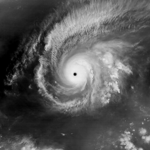
Re: Arabian Sea: CHAPALA - Extremely Severe Cyclonic Storm
Strong cat 3 and still forecast to weaken by time of landfall.

REMARKS:
012100Z POSITION NEAR 13.3N 53.1E.
TROPICAL CYCLONE (TC) 04A (CHAPALA), LOCATED APPROXIMATELY 520 NM
SOUTHWEST OF MASIRAH ISLAND, HAS TRACKED WESTWARD AT 10 KNOTS
OVER THE PAST SIX HOURS. ANIMATED ENHANCED INFRARED (EIR) SATELLITE
IMAGERY DEPICTS AN IMPROVEMENT IN THE OVERALL CONVECTIVE SIGNATURE
SURROUNDING AN ENLARGED 20-NM EYE. A 011550Z SSMIS 91GHZ MICROWAVE
IMAGE FURTHER SHOWS THE STRENGTHENING WITHIN THE CONVECTIVE CORE
WHICH, IN ADDITION TO DVORAK CURRENT INTENSITY ESTIMATES RANGING
FROM 102 TO 115 KNOTS, SUPPORTS THE INITIAL INTENSITY BEING
INCREASED TO 110 KNOTS. THE CURRENT POSITION IS BASED ON THE EYE
FEATURE IN THE EIR LOOP WITH HIGH CONFIDENCE. WATER VAPOR IMAGERY
REVEALS AN IMPROVED POLEWARD OUTFLOW CHANNEL WHICH IS SUPPORTING THE
INTENSIFICATION IN CENTRAL CONVECTION. SOUTHERLY VERTICAL WIND SHEAR
(VWS) REMAINS AT 10 TO 15 KNOTS. TC 04A IS TRACKING ALONG THE
SOUTHERN PERIPHERY OF A DEEP-LAYERED SUBTROPICAL RIDGE (STR) TO THE
NORTH. THE CYCLONE WILL CONTINUE TRACKING WESTWARD TOWARDS THE COAST
OF YEMEN, MAKING LANDFALL NEAR TAU 36. THE TRACK HAS SHIFTED
WESTWARD AS THE STEERING STR STRENGTHENS AND EXTENDS FURTHER WEST.
TC CHAPALA WILL BEGIN TO WEAKEN ONCE AGAIN AS THE SYSTEM ENCOUNTERS
INCREASED VWS AND DRY AIR. IN ADDITION, LAND INTERACTION WILL BEGIN
TO DETERIORATE THE LOW LEVEL STRUCTURE. THE CYCLONE WILL TRACK OVER
CENTRAL YEMEN AND FULLY DISSIPATE OVER LAND BY THE END OF THE
FORECAST PERIOD. DYNAMIC MODEL GUIDANCE REMAINS IN GOOD AGREEMENT,
LENDING HIGH CONFIDENCE TO THE JTWC FORECAST. MAXIMUM SIGNIFICANT
WAVE HEIGHT AT 011800Z IS 28 FEET. NEXT WARNINGS AT 020300Z,
020900Z, 021500Z AND 022100Z.//
NNNN
0 likes
Remember, all of my post aren't official. For official warnings and discussions, Please refer to your local NWS products...
NWS for the Western Pacific
https://www.weather.gov/gum/
NWS for the Western Pacific
https://www.weather.gov/gum/
-
WeatherGuesser
- Category 5
- Posts: 2672
- Joined: Tue Jun 29, 2010 6:46 am
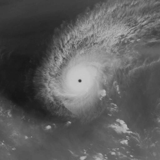
A rare and rapidly intensifying cyclone killed one person and injured nine Sunday on the remote Yemeni island of Socotra as it moved toward the Yemeni mainland, local security officials said.
The officials said Cyclone Chapala seriously damaged or destroyed at least 20 homes on the island, where trees have been uprooted and fishing boats sank.
They said many residents living near the coast are taking shelter in caves or in schools. The island is being hit by heavy rain and strong winds, and rising waves are battering the coast. The officials said coastal areas are flooded.
http://abcnews.go.com/International/wir ... e-34891615
0 likes
-
Kingarabian

- S2K Supporter
- Posts: 15434
- Joined: Sat Aug 08, 2009 3:06 am
- Location: Honolulu, Hawaii
-
wxmann_91

- Category 5
- Posts: 8013
- Age: 32
- Joined: Fri Jul 15, 2005 2:49 pm
- Location: Southern California
- Contact:
Re:
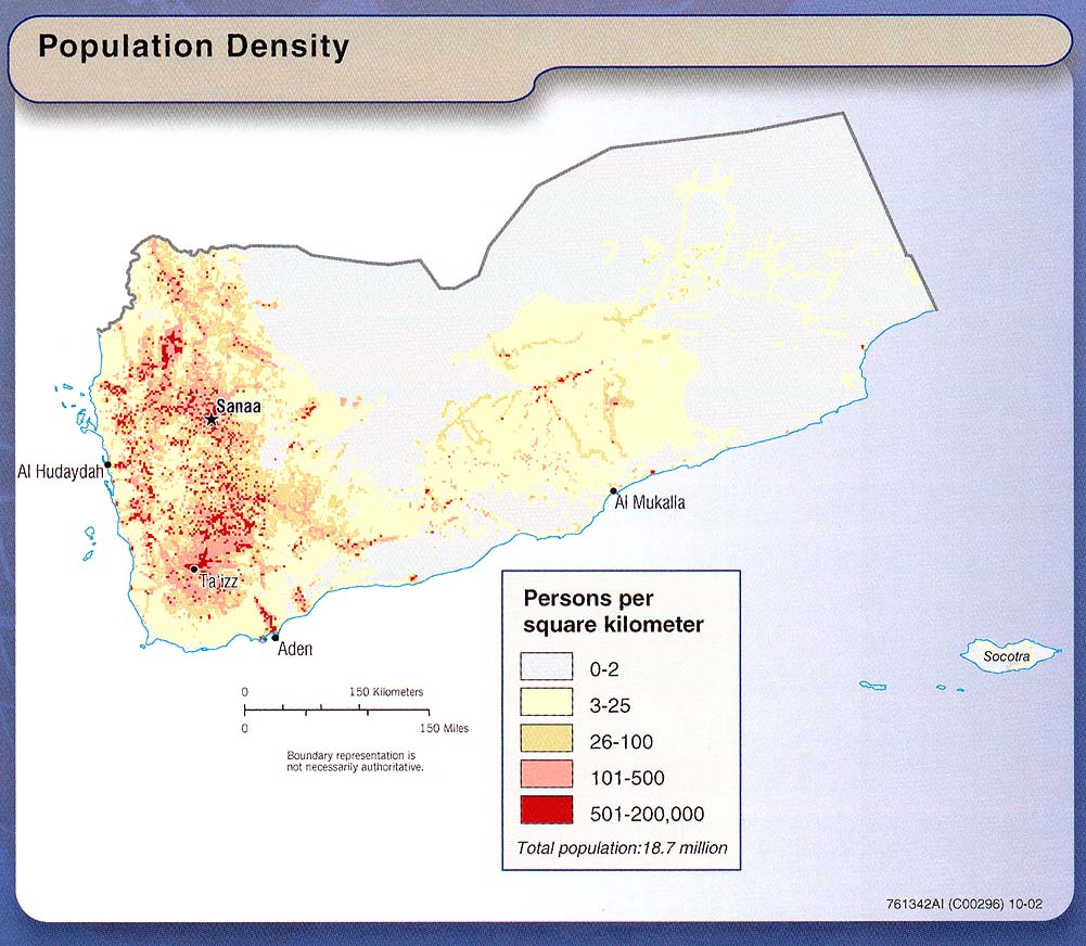
Kingarabian wrote:Looks like a further west and south motion would mean a weaker Chapala. Let's hope it continues.
But would not be good from a population affected perspective:
0 likes
-
1900hurricane
- Category 5
- Posts: 6044
- Age: 32
- Joined: Fri Feb 06, 2015 12:04 pm
- Location: Houston, TX
- Contact:
Maybe yet another eyewall replacement cycle?

0 likes
Contract Meteorologist. TAMU & MSST. Fiercely authentic, one of a kind. We are all given free will, so choose a life meant to be lived. We are the Masters of our own Stories.
Opinions expressed are mine alone.
Follow me on Twitter at @1900hurricane : Read blogs at https://1900hurricane.wordpress.com/
Opinions expressed are mine alone.
Follow me on Twitter at @1900hurricane : Read blogs at https://1900hurricane.wordpress.com/
https://twitter.com/adennetwork/status/ ... 9500605441
something horrific may be going on Socotra. Now multiply that by about 100 for the impacts on the mianland
something horrific may be going on Socotra. Now multiply that by about 100 for the impacts on the mianland
0 likes
-
terstorm1012
- S2K Supporter
- Posts: 1313
- Age: 42
- Joined: Fri Sep 10, 2004 5:36 pm
- Location: Millersburg, PA
Re:
terstorm1012 wrote:so much farther west that most (but you alyono) forecasted. this is going to be a catastrophe.
Most missed this because they dogmatically followed deterministic runs and did not look at the ensemble envelope. 20th century techniques vs 21 st century techniques
0 likes
Who is online
Users browsing this forum: No registered users and 137 guests