ATL: HERMINE - Post-Tropical - Discussion
Moderator: S2k Moderators
-
Hurrilurker

- Category 2

- Posts: 738
- Joined: Mon Jun 09, 2003 3:32 pm
- Location: San Francisco, CA
Re: ATL: INVEST 99L - Discussion
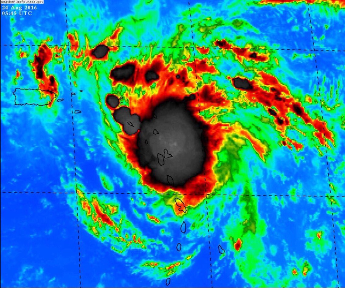
Would be crazy if it jumped from nothing to a Cat 1 by the morning update. I mean maybe it's not as well organized/stacked as it looks on IR but the chances of it not developing into something seem remote at this point. Convection is bombing and consolidating and you can see the rotation on Guadalupe radar. I also don't see a lot of that dry air to the west getting pulled in.
0 likes
-
Socalhurcnegirl227
- Category 1

- Posts: 267
- Age: 37
- Joined: Mon Jun 06, 2016 6:39 pm
- Location: Santa Barbara, CA
Re: ATL: INVEST 99L - Discussion
the morning update should be interesting, wondering if this storm did infact just escalate to near Cat 1 strength. Didnt danny or one of the storms last year do this?
0 likes
"I'm a wandress, i'm a one night stand,
dont belong to no city, dont belong to no man
i'm the violence in the pouring rain,
I'm a hurricane"
dont belong to no city, dont belong to no man
i'm the violence in the pouring rain,
I'm a hurricane"
-
Socalhurcnegirl227
- Category 1
- Posts: 267
- Age: 37
- Joined: Mon Jun 06, 2016 6:39 pm
- Location: Santa Barbara, CA
Re: ATL: INVEST 99L - Discussion
Hurrilurker wrote:Would be crazy if it jumped from nothing to a Cat 1 by the morning update. I mean maybe it's not as well organized/stacked as it looks on IR but the chances of it not developing into something seem remote at this point. Convection is bombing and consolidating and you can see the rotation on Guadalupe radar. I also don't see a lot of that dry air to the west getting pulled in.
like the drake song goes "0 to 100 real quick!" lol
0 likes
"I'm a wandress, i'm a one night stand,
dont belong to no city, dont belong to no man
i'm the violence in the pouring rain,
I'm a hurricane"
dont belong to no city, dont belong to no man
i'm the violence in the pouring rain,
I'm a hurricane"
-
Medtronic15

- Tropical Depression

- Posts: 53
- Age: 45
- Joined: Fri Jul 01, 2016 5:25 am
- Location: Texas,USA
Re: ATL: INVEST 99L - Discussion
TD, TS or Hurricane?
0 likes
The posts in this forum are NOT official forecast and should not be used as such. They are just the opinion of the poster and may or may not be backed by sound meteorological data. They are NOT endorsed by any professional institution or STORM2K. For official information, please refer to products from the NHC and NWS.
-
CaliforniaResident
- Tropical Storm

- Posts: 215
- Joined: Fri Feb 21, 2014 1:47 pm
Re: ATL: INVEST 99L - Discussion
Looks very similar to the path of Katrina, hitting South FL as a cat 1 and then blossoming into a MH in the Gulf and making a beeline for New Orleans. Scary times ahead.
Last edited by CaliforniaResident on Wed Aug 24, 2016 1:48 am, edited 1 time in total.
0 likes

Re: ATL: INVEST 99L - Discussion
Medtronic15 wrote:https://pbs.twimg.com/media/CqmvWWMVUAAw4al?format=jpg&name=large
TD, TS or Hurricane?
Your guess is as good as all of ours. I think it will all depend on surface obs and buoy obs. I think at least 50mph TS
0 likes
Personal Forecast Disclaimer:
The posts in this forum are NOT official forecast and should not be used as such. They are just the opinion of the poster and may or may not be backed by sound meteorological data. They are NOT endorsed by any professional institution or storm2k.org. For official information, please refer to the NHC and NWS products.
The posts in this forum are NOT official forecast and should not be used as such. They are just the opinion of the poster and may or may not be backed by sound meteorological data. They are NOT endorsed by any professional institution or storm2k.org. For official information, please refer to the NHC and NWS products.
-
JtSmarts

- S2K Supporter

- Posts: 1442
- Age: 40
- Joined: Thu Jul 10, 2003 1:29 pm
- Location: Columbia, South Carolina
Re: ATL: INVEST 99L - Discussion
It's so fascinating to watch the genesis of these incredible storms. We're definitely not in 2015 anymore, stay safe and prepared all of you who may be in the path!
2 likes
-
Aric Dunn
- Category 5

- Posts: 21238
- Age: 43
- Joined: Sun Sep 19, 2004 9:58 pm
- Location: Ready for the Chase.
- Contact:
Re: ATL: INVEST 99L - Discussion
Blinhart wrote:Medtronic15 wrote:https://pbs.twimg.com/media/CqmvWWMVUAAw4al?format=jpg&name=large
TD, TS or Hurricane?
Your guess is as good as all of ours. I think it will all depend on surface obs and buoy obs. I think at least 50mph TS
no its very straight forward and easy to see.
0 likes
Note: If I make a post that is brief. Please refer back to previous posts for the analysis or reasoning. I do not re-write/qoute what my initial post said each time.
If there is nothing before... then just ask
Space & Atmospheric Physicist, Embry-Riddle Aeronautical University,
I believe the sky is falling...
If there is nothing before... then just ask
Space & Atmospheric Physicist, Embry-Riddle Aeronautical University,
I believe the sky is falling...
Re: ATL: INVEST 99L - Discussion
Do we have any condition reports from those islands? May shed some light.
Last edited by ronyan on Wed Aug 24, 2016 1:53 am, edited 1 time in total.
0 likes
-
Socalhurcnegirl227
- Category 1
- Posts: 267
- Age: 37
- Joined: Mon Jun 06, 2016 6:39 pm
- Location: Santa Barbara, CA
Re: ATL: INVEST 99L - Discussion
CaliforniaResident wrote:Looks very similar to the path of Katrina, hitting South FL as a cat 1 and then blossoming into a MH in the Gulf and making a beeline for New Orleans. Scary times ahead.
Many people on here have been saying this the past couple days now which is extremely unsettling. I started noticing the similarities as well. Some have gone as far to say Katrina being a good analog for this storm.
0 likes
"I'm a wandress, i'm a one night stand,
dont belong to no city, dont belong to no man
i'm the violence in the pouring rain,
I'm a hurricane"
dont belong to no city, dont belong to no man
i'm the violence in the pouring rain,
I'm a hurricane"
Re: ATL: INVEST 99L - Discussion
Aric Dunn wrote:Blinhart wrote:Medtronic15 wrote:https://pbs.twimg.com/media/CqmvWWMVUAAw4al?format=jpg&name=large
TD, TS or Hurricane?
Your guess is as good as all of ours. I think it will all depend on surface obs and buoy obs. I think at least 50mph TS
no its very straight forward and easy to see.
So what do you see?
0 likes
Personal Forecast Disclaimer:
The posts in this forum are NOT official forecast and should not be used as such. They are just the opinion of the poster and may or may not be backed by sound meteorological data. They are NOT endorsed by any professional institution or storm2k.org. For official information, please refer to the NHC and NWS products.
The posts in this forum are NOT official forecast and should not be used as such. They are just the opinion of the poster and may or may not be backed by sound meteorological data. They are NOT endorsed by any professional institution or storm2k.org. For official information, please refer to the NHC and NWS products.
-
Incident_MET

- Professional-Met

- Posts: 63
- Joined: Tue Mar 28, 2006 10:22 pm
- Location: Floridana Beach, FL
Re: ATL: INVEST 99L - Discussion
Radar from Barbados weather site shows some banding developing in radar presentation
http://www.barbadosweather.org/Composite/kidbuuComposite_displayer.php?Product=Reflectivity&Sector=EC_Bar&Composite=Sabre&PlanetOfTheApes=1472020771
http://www.barbadosweather.org/Composite/kidbuuComposite_displayer.php?Product=Reflectivity&Sector=EC_Bar&Composite=Sabre&PlanetOfTheApes=1472020771
0 likes
-
SeGaBob
Re: ATL: INVEST 99L - Discussion
No way this doesn't get named. But then again "poof" could happen as well.
Last edited by SeGaBob on Wed Aug 24, 2016 1:59 am, edited 1 time in total.
0 likes
-
Kingarabian

- S2K Supporter
- Posts: 16370
- Joined: Sat Aug 08, 2009 3:06 am
- Location: Honolulu, Hawaii
Re: ATL: INVEST 99L - Discussion
NHC will likely wait for a new ASCAT pass, an ob from a buoy or a ship or wait for recon tomorrow. But they could have a TD by the next update.
0 likes
RIP Kobe Bryant
-
Aric Dunn
- Category 5
- Posts: 21238
- Age: 43
- Joined: Sun Sep 19, 2004 9:58 pm
- Location: Ready for the Chase.
- Contact:
Re: ATL: INVEST 99L - Discussion
Blinhart wrote:Aric Dunn wrote:Blinhart wrote:
Your guess is as good as all of ours. I think it will all depend on surface obs and buoy obs. I think at least 50mph TS
no its very straight forward and easy to see.
So what do you see?
amazing its happening right in front of us.. very much the most fun of the tropics.
its very clear.

2 likes
Note: If I make a post that is brief. Please refer back to previous posts for the analysis or reasoning. I do not re-write/qoute what my initial post said each time.
If there is nothing before... then just ask
Space & Atmospheric Physicist, Embry-Riddle Aeronautical University,
I believe the sky is falling...
If there is nothing before... then just ask
Space & Atmospheric Physicist, Embry-Riddle Aeronautical University,
I believe the sky is falling...

Re: ATL: INVEST 99L - Discussion
Banding circulation still looks mid-level. The rain outside the rain shield is still out of the south to the west of the islands, and out of the southwest to the south of Saint Kitts.
1 likes
The above post is not official and should not be used as such. It is the opinion of the poster and may or may not be backed by sound meteorological data. It is not endorsed by any professional institution or storm2k.org. For official information, please refer to the NHC and NWS products.
-
wflamholtz

- Tropical Low

- Posts: 30
- Age: 30
- Joined: Sun Jul 31, 2016 8:30 pm
- Contact:
Re: ATL: INVEST 99L - Discussion
Aric Dunn wrote:Blinhart wrote:Aric Dunn wrote:no its very straight forward and easy to see.
So what do you see?
amazing its happening right in front of us.. very much the most fun of the tropics.
its very clear.
https://s3.postimg.io/o55i0d8o3/Hermine ... 160246.png
I actually think it's an MCV from that storm cluster
0 likes
-
Aric Dunn
- Category 5
- Posts: 21238
- Age: 43
- Joined: Sun Sep 19, 2004 9:58 pm
- Location: Ready for the Chase.
- Contact:
Re: ATL: INVEST 99L - Discussion
Hammy wrote:Banding circulation still looks mid-level. The rain outside the rain shield is still out of the south to the west of the islands, and out of the southwest to the south of Saint Kitts.
that circ is so close to the the radar.. its not mid level..
0 likes
Note: If I make a post that is brief. Please refer back to previous posts for the analysis or reasoning. I do not re-write/qoute what my initial post said each time.
If there is nothing before... then just ask
Space & Atmospheric Physicist, Embry-Riddle Aeronautical University,
I believe the sky is falling...
If there is nothing before... then just ask
Space & Atmospheric Physicist, Embry-Riddle Aeronautical University,
I believe the sky is falling...
Who is online
Users browsing this forum: No registered users and 91 guests